OFFICIAL
DESCRIPTION CHANGE
OFFICE:
Research and Analytics
EFFECTIVE
DATE: 9-20-2016
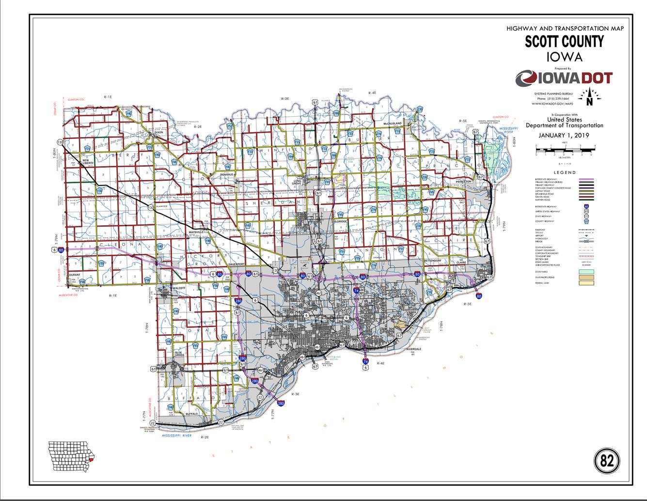
COUNTY:
Scott
ROUTE:
US 67
ENTERED
BY: Paul Mauer
ENTERED
DATE: 12-20-2019
New
Description ‑ US 67 and its extensions in
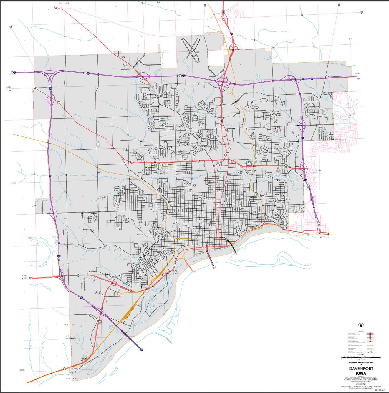
Beginning
on the Centennial Bridge as the south corporation line; thence northerly on the
Centennial Bridge to West 2nd Street; thence east on West 2nd Street to Gaines
Street; thence south on Gaines Street to West River Drive; thence east on West
River Drive to East River Drive; thence easterly and northeasterly on East
River Drive to the east corporation line.
Also
Beginning
at
Beginning
on River Drive at the west corporation line; thence easterly on River Drive to
6th Street, (begin one‑way eastbound); thence easterly on State Street to
10th Street; thence northeasterly and easterly and southeasterly on
Grant Street to 17th Street; thence easterly on State Street to 26th
Street (end one‑way eastbound); thence easterly and northeasterly on
State Street to the east corporation line.
Also
Beginning
at the intersection of State Street and 26th Street (begin one‑way
westbound); thence westerly on Grant Street to the intersection of Grant Street
and 6th Street; thence south an 6th Street to the intersection of 6th Street
and State Street (end one‑way westbound).
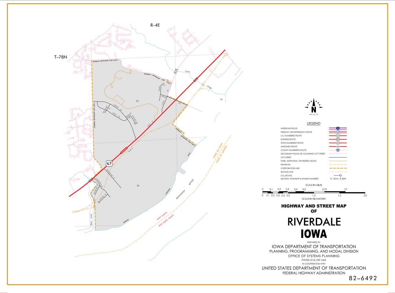
Riverdale:
Beginning
on
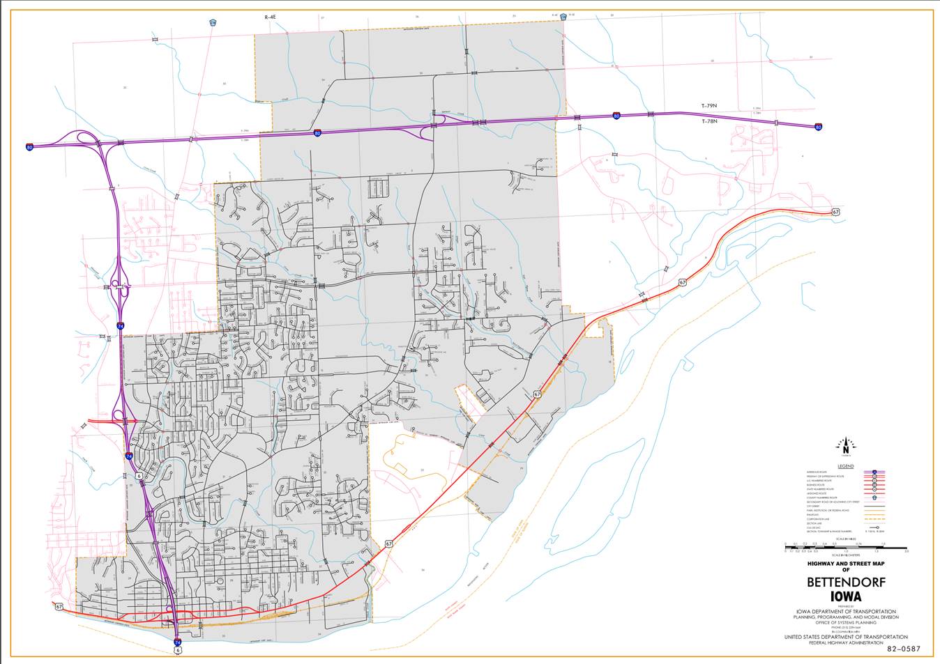
Bettendorf:
Beginning
on
Beginning
again on the east corporation line of Bettendorf connecting with State Street;
thence northeasterly through Sections 18, 7, 8 and 9‑T78N‑R5E to
the west corporation line of Le Claire, connecting with Cody Road.
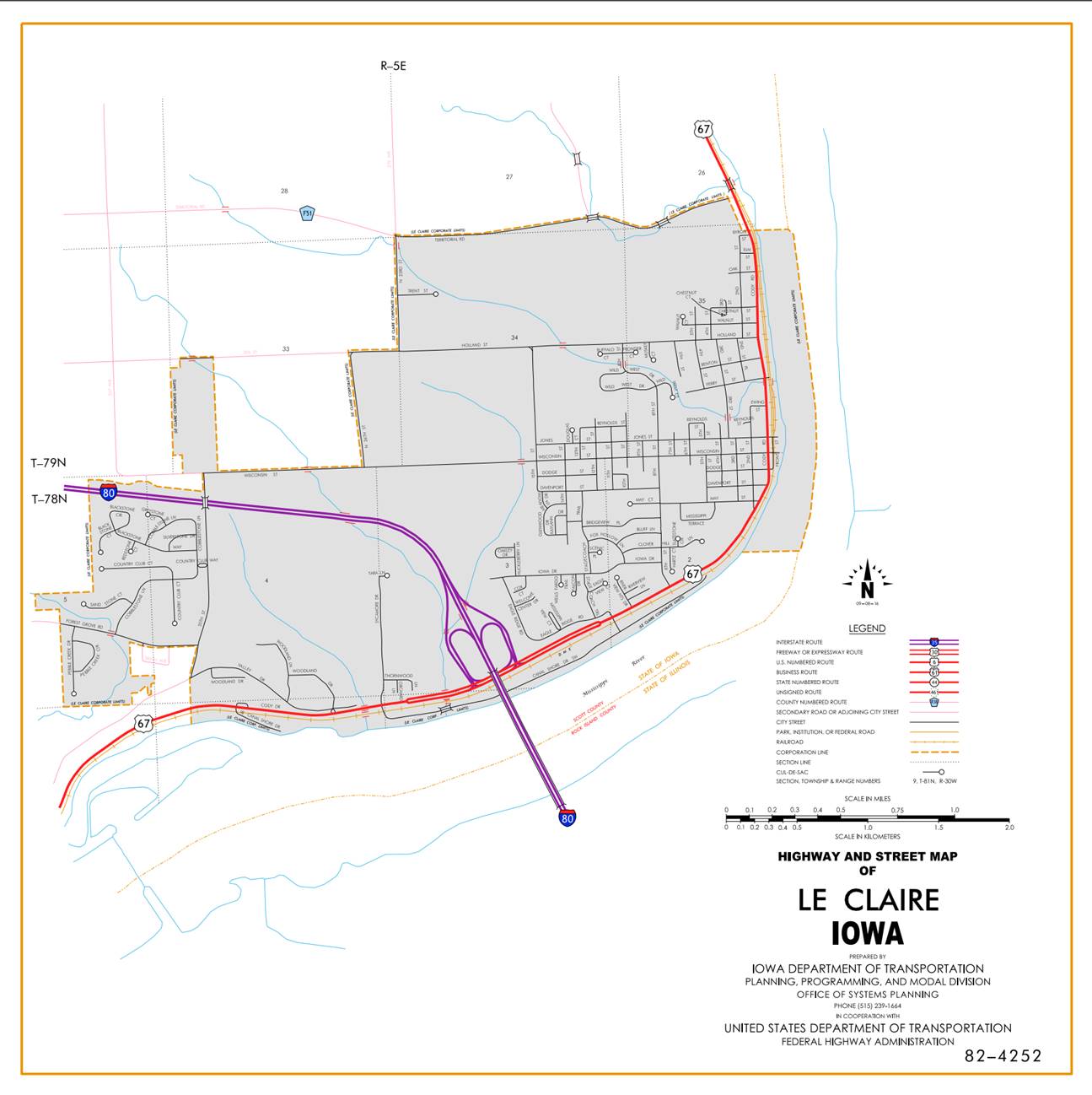
Le
Claire:
Beginning
on Cody Road at the west corporation line; thence easterly and northeasterly on
Cody Road (junction Interstate 80); thence northerly on Cody Road to the north
corporation line.
Beginning
again on the north corporation line of Le Claire connecting with Cody Road;
thence in a northerly direction through Sections 26, 23, 14 and 11‑T79N‑R5E
to the south corporation line of Princeton, connecting with Great River Road.
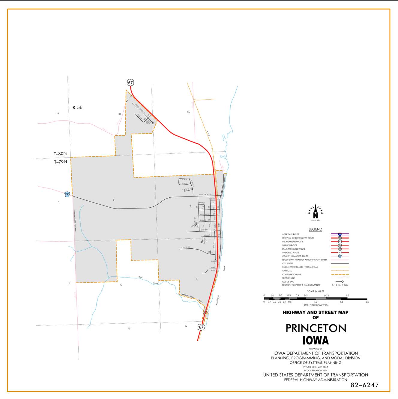
Beginning
on Great River Road at the south corporation line; thence in a northerly
direction on Great River Road to the north corporation line.
Beginning
again on the north corporation line of Princeton connecting with Great River
Road; thence in a northerly direction through Section 2‑T79N‑R5E,
and in a northwesterly and northerly direction through Sections 35, 34, 27 and
22‑T80N‑R5E to the Scott‑Clinton County line (Wapsipinicon
River) at a point approximately ½ mile east of the N ¼ Corner Section 22‑T80N‑R5E.
OFFICIAL
DESCRIPTION CHANGE
COUNTY: Scott
ROUTE: US 67
STAFF
ACTION NUMBER: S-87-1513
APPROVAL
DATE: 5-13-87
New
Description ‑ US 67 and its extensions in
Beginning
on the Centennial Bridge as the south corporation line; thence northerly on the
Centennial Bridge to West 2nd Street; thence east on West 2nd Street to Gaines
Street; thence south on Gaines Street to West River Drive; thence east on West
River Drive to East River Drive; thence easterly and northeasterly on East
River Drive to the east corporation line.
Also
Beginning
at
Beginning
on
Also
Beginning
at the intersection of State Street and 26th Street (begin one‑way
westbound); thence westerly on Grant Street to the intersection of Grant Street
and 6th Street; thence south an 6th Street to the intersection of 6th Street
and State Street (end one‑way westbound).
Riverdale:
Beginning
on
Beginning
on
Beginning
again on the east corporation line of Bettendorf connecting with State Street;
thence northeasterly through Sections 18, 7, 8 and 9‑T78N‑R5E to
the south corporation line of Le Claire, connecting with an unnamed street.
Le
Claire:
Beginning
on an unnamed street at the west corporation line; thence easterly and
northeasterly on an unnamed street to Cody Road; thence northerly on
Beginning
again on the north corporation line of Le Claire connecting with Cody Road;
thence in a northerly direction through Sections 26, 23, 14 and 11‑T79N‑R5E
to the south corporation line of Princeton, connecting with an unnamed street.
Beginning
on an unnamed street at the south corporation line; thence in a northerly
direction on said unnamed street to the north corporation line.
Beginning
again on the north corporation line of
COMMISSION
ORDER
DIVISION: Planning & Research
COMMISSION
ORDER NUMBER:
PR-79-272
SUBMITTED
BY: C.I. MacGillivray
MEETING
DATE:
11-2-78
TITLE: US 67,
DISCUSSION/BACKGROUND:
US
67 begins on the south corporation line of
Due
to a review of our Primary Road System Records US 67 in
PROPOSAL/ACTION
RECOMMENDATION:
It
is recommended that the old description of US 67 in
Locate
US 67 and its extensions in
Beginning
on the Centennial Bridge at the south corporation line (Iowa‑Illinois
State line); thence in a general northerly and northeasterly direction to the
east corporation line (west corporation line of the City of Bettendorf)
connecting with an unnamed street.
Also
Beginning
at
Beginning
on the west corporation line (east corporation line of the City of
Also
Beginning
at the intersection of State Street and 26th Street (begin one‑way
westbound); thence westerly on Grant Street to the intersection of Grant Street
and 6th Street; thence south on 6th Street to the intersection of 6th Street
and State Street (end one‑way westbound).
Riverdale:
Beginning
on the west corporation line (easterly corporation line of the City of
Beginning
on the south corporation line connecting with an unnamed street (north corporation
line of the City of
Beginning
again on the east corporation line of the City of Bettendorf connecting with an
unnamed street on the northwest side of the Davenport, Rock Island, and
Northwestern Railway; thence in a northeasterly direction along the northwest
side of said railway and substantially parallel thereto through Sections 18, 7,
8, and 9‑T78N‑R5E to the south corporation line of the City of
Le
Claire:
Beginning
on the west corporation line connecting with an unnamed street; thence in a
northeasterly and northerly direction to the north corporation line connecting
with an unnamed street.
Beginning
again on the north corporation line of the City of Le Claire connecting with an
unnamed street on the west side of the Davenport, Rock Island, and Northwestern
Railway; thence in a northerly direction along the west side of said railway
and substantially parallel thereto through Sections 26, 23, and 14 &
11-T79N‑R5E to the south corporation line of the City of
Beginning
on the south corporation line connecting with an unnamed street; thence in a
northerly direction to the north corporation line connecting with an unnamed
street.
Beginning
again on the north corporation line of the City of Princeton connecting with an
unnamed street; thence in a northerly direction through Section 2‑T79N‑R5E
and in a northwesterly and northerly direction through Sections 35, 34, 27, and
22‑T80N‑R5E to the Scott‑Clinton County line (Wapsipinicon
River) at a point approximately ¼ mile east of the N ¼ Corner Section 22‑T80N‑R5E.
REVISED: 5-13-87
COMMISSION
RESOLUTION
DIVISION: Planning & Research
COMMISSION
ORDER NUMBER:
73-1185
SUBMITTED
BY: Gene R. Mills
MEETING
DATE:
9-19-73
TITLE: Approving the location of the extension of US
67 in Scott County
Locate
US 67 in Scott County, Iowa, as follows:
Beginning
on
Also
Beginning
at the intersection of
NOW,
THEREFORE: Be it resolved that the Iowa
State Highway Commission approve the location of the extension of US 67 in
Scott County,
NOTE: To become effective upon adoption of this
resolution in accordance with Iowa State Highway Commission Resolution 66‑SP‑169.
OFFICIAL
DESCRIPTION CHANGE
COUNTY: Scott
ROUTE: US 67
APPROVAL
DATE: 3-11-59
Beginning
on the east corporation line of the City of Bettendorf, connecting with State
Street; thence in a northeasterly direction through Section 27‑T78N‑R4E
to the west corporation line of the Town of Riverdale, connecting with an
unnamed street.
Beginning
again at the north corporation line of the Town of Riverdale, connecting with
an unnamed street; thence northeasterly through Sections 23 and 24‑T78N‑R4E
to a point on the northwest side of the Davenport, Rock Island and Northwestern
Railway approximately 250 feet east of the N ¼ Corner Section 24‑T78N‑R4E;
thence in a northeasterly direction along the northwest side of said railway
and substantially parallel thereto through Sections 13‑T78N‑R4E and
Sections 18, 7, 8, 9, 10, 3 and 2‑T78N‑R5E to the south corporation
line of the Town of Le Claire, connecting with Main Street.
Beginning
again on the north corporation line of the Town of Le Claire, connecting with
Main Street; thence in a northerly direction through Sections 26, 23, 14, and
11‑T79N‑R5E, to the south corporation line of the Town of
Princeton, connecting with Second Street.
Beginning
again on the north corporation line of the Town of Princeton, connecting with
Second Street; thence in a northerly direction through Section 2‑T79N‑R5E,
and in a northwesterly and northerly direction through Sections 35, 34, 27 and
22‑T80N‑R5E, to the Scott‑Clinton County Line (Wapsipinicon
River) at a point approximately ¼ mile east of the N ¼ Corner Section 22‑T80N‑R5E.
NOTE:
Designation to become effective upon the completion and opening to traffic of
relocated US 67, more specifically Scott County Project F‑114 (7).
OFFICIAL
DESCRIPTION CHANGE
COUNTY: Scott
CITY
OF: Riverdale
ROUTE: US 67
APPROVAL
DATE: 3-11-59
Beginning
on the west corporation line at a point 553.4 feet north of the W ¼ Corner
Section 26‑T78N‑R4E, connecting with an unnamed street; thence
northeasterly 7096 feet to the north corporation line (north line Fenno Road) at a point approximately 145 feet south and 45
feet west of the E ¼ Corner Section 23‑T78N‑R4E.
NOTE:
Designation to become effective upon the completion and opening to traffic of
relocated US 67, more specifically Scott County Project F-114(7).
OFFICIAL
DESCRIPTION CHANGE
COUNTY: Scott
CITY
OF:
ROUTE: US 67
APPROVAL
DATE: 5-3-55
Beginning
on Centennial Bridge at the south corporation line; thence northerly on the
Centennial Bridge to West Second Street; thence east on West Second Street to
Gaines Street; thence south on Gaines Street to West River Street; thence east
on West River Street to East River Street; thence easterly and northeasterly on
East River Street to River Drive; thence southeasterly on River Drive to the
east corporation line.
Also
Beginning
at the intersection of
OFFICIAL
DESCRIPTION CHANGE
COUNTY: Scott
CITY
OF:
ROUTE: US 67
APPROVAL
DATE: 2-5-36
Commencing
on State Street at the west corporation; thence easterly on State Street to the
corporation line.
OFFICIAL
DESCRIPTION CHANGE
COUNTY: Scott
CITY
OF: Le Claire
ROUTE: US 67
APPROVAL
DATE: 2-5-36
Commencing
at the south corporation line; thence northeasterly and northerly on Main
Street to the north corporation line.
OFFICIAL
DESCRIPTION CHANGE
COUNTY: Scott
CITY
OF:
ROUTE: US 67
APPROVAL
DATE: 2-5-36
Commencing
on Second Street at the south corporation line; thence northerly on Second
Street to the north corporation line.