OFFICAL DESCRIPTION CHANGE
OFFICE: Transportation Data
EFFECTIVE DATE: 12-15-2010
COUNTY: Webster
ROUTE: US 20
ENTERED BY: Cheryl Cowie
ENTERED DATE: 3-1-2011
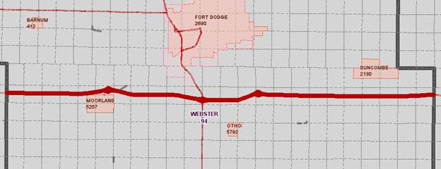
New description of US 20 and its extension in Webster County described as follows:
Beginning
on The Webster‑Calhoun County line at a point
near the NW Corner of the SW Quarter of Section 7-T88N‑R31W, Webster
County (NE Corner of the SE Quarter of Section 12-T88N‑R31W, Calhoun
County), traversing east through sections 7, 8, 9, 10, 11 and 12-T88N‑R30W,
to the Junction of County Road D36 (Grant Ave) approximately 1277.76 feet south
of the north section of Section 12, then continues east through Sections 7, 8,
9, 10, and 11- T88N‑R29W to a point 1261.92 feet north of the SW Corner
of Section 12-T88N‑R29W and the junction of US169, then easterly through
Section 12‑T88N‑R29W and Section 7‑T88N‑R28W; then
northeasterly and easterly following essentially the centerline of Sections 8,
9, 10, 11 and 12‑T88N‑R28W and Sections 7, 8, 9, 10, 11 and 12‑T88N‑R27W
to the Webster‑Hamilton County line (Section 7‑T88N‑R26W
Hamilton County).
STAFF
ACTION
OFFICE: Transportation Inventory
STAFF
ACTION NUMBER:
S-95-348
SUBMITTED
BY: Patrick R. Cain
SUBMITTAL
DATE:
8-16-94
TITLE: Official Description Change: US 20, Fort Dodge in Webster County
DISCUSSION/BACKGROUND:
Due
to the relocation of US 20 in Webster County and the transfer of jurisdiction
agreement number 88-TJ-005-94 between the Iowa Department of Transportation and
the City of Fort Dodge, the section of old US 20 in Fort Dodge from 8th Street
east to County Road P59 was transferred to the City of Fort Dodge on December
7, 1990 and should be deleted from the Primary Road System.
This
section of old US 20 begins at the junction of East Kenyon Road and 8th Street
in Fort Dodge; then northeast to 5th Avenue and 12th Street; then follows 5th
Avenue east to County Road P59 near the east corporation line of Fort Dodge.
PROPOSAL/ACTION
RECOMMENDATION:
It
is recommended that the old section of US 20 described above be deleted from
the Primary Road System.
STAFF
ACTION
OFFICE: Transportation Inventory
STAFF
ACTION NUMBER:
S-93-641
SUBMITTED
BY: Patrick R. Cain
SUBMITTAL
DATE:
10-19-92
TITLE: Official Description Change: US
20, Webster County
DISCUSSION/BACKGROUND:
Due
to the relocation of US 20 in Webster
County, the official
description of this route should be revised to reflect the new alignment. The
portion of new US 20 from Mooreland to Coalville was
opened to traffic on December 7, 1990 and from Coalville
east to the Iowa 17 interchange in Hamilton County on July 2, 1987. The alignment of
US 20 from the Calhoun
Webster County
line to Moorland remains unchanged.
PROPOSAL/ACTION
RECOMMENDATION:
It
is recommended to approve revising the description of US 20 in Webster County and to include the attached new
description in the Primary Road System.
New
Description ‑ US 20 and its extension in Webster County described as follows:
Beginning
on The Webster‑Calhoun County line at a point near the SW Corner Section
30‑T88N‑R30W, Webster County, (SE Corner Section 25‑T88N‑R31W,
Calhoun County); then east following substantially the section line of Section
31‑T88N‑R30W to a point approximately 700 feet east of the SW
Corner Section 30‑T88N‑R30W; then northeast along the north side of
the Chicago Northwestern Railroad and substantially parallel thereto through
Sections 30, 29, 20, 21, 22, 15 and 14‑T88N‑R30W to the west
corporation line of Moorland, connecting with an unnamed street.
Moorland:
Beginning
on the west corporation line connecting with an unnamed street; then northeast
to the north corporation line.
Beginning
again on the north corporation line of Moorland and curving northeasterly through
the northeast ¼ Corner of Section 12‑T88N‑R30W; then curving
southeasterly and easterly through Sections 7, 8, 9, 10, and 11-T88N‑R29W
(Interchange with US 169, begin multilane divided highway); then easterly
through Section 12‑T88N‑R29W and Section 7‑T88N‑R28W;
then northeasterly and easterly following essentially the centerline of
Sections 8, 9, 10, 11 and 12‑T88N‑R28W and Sections 7, 8, 9, 10, 11
and 12‑T88N‑R27W to the Webster‑Hamilton County line (Section
7‑T88N‑R26W Hamilton County).
OFFICIAL
DESCRIPTION CHANGE
COUNTY: Webster
ROUTE: US 20
STAFF
ACTION NUMBER: S-87-1501
APPROVAL
DATE: 5-13-87
New
Description US 20 and its extensions in Webster County
described as follows:
Beginning
on the Webster‑Calhoun County line at a point near the SW Corner Section
30‑T88N‑R30W, Webster County, (SE Corner Section 25‑T88N‑R31W,
Calhoun County); then east following substantially the section line of Section
31‑T88N‑R30W to a point approximately 700 feet east of the SW
Corner Section 30‑T88N‑R30W; then northeast along the north side of
the Chicago Northwestern Railroad and substantially parallel thereto through
Sections 30, 29, 20, 21, 22, 15 and 14‑T88N‑R30W to the west
corporation line of Moorland, connecting with an unnamed street.
Moorland:
Beginning
on the west corporation line connecting with an unnamed street; then northeast
to the north corporation line connecting with an unnamed street.
Beginning
on the north corporation line of Moorland, connecting with an unnamed street;
then northeast along the north side of the Chicago Northwestern Railroad and
substantially parallel thereto through Section 12‑T88N‑R30W, and
Sections 7, 6, 5 and 4‑T88N‑R29W, and Section 35 and 36‑T89N‑R29W
to a point approximately ¼ mile west and ¾ mile north of the E ¼ Corner of
Section 36‑T89N‑R29W; then northeast through Section 36‑T89N‑R29W
to a point approximately 900 feet south of the NE Corner said Section 36
(junction US 169); then northeast through Section 31‑T89N‑R28W to
the west corporation line of Fort Dodge, connecting with Kenyon Road.
Fort Dodge:
Beginning
on Kenyon Road at the west corporation line; then northeast on Kenyon Road to
5th Avenue South; then east on 5th Avenue South to the east corporation line.
Beginning
again on the east corporation line of Fort
Dodge connecting with 5th Avenue South; then east following
substantially the section line of Sections 27, 26 and 25‑T89N‑R28W
and Sections 30, 29, 28, 27 and 26‑T89N‑R27W to a point
approximately 1,100 feet west of the NE Corner Section 26‑T89N‑R27W;
then curving southeast through Section 26‑T89N‑R27W to a point
approximately 1,100 feet south of the NE Corner said Section 26; then south
following substantially the section line of Sections 25 and 36‑T89N‑R27W
to a point approximately 700 feet north of the SW Corner Section 36‑T89N‑R27W;
then curving in a southeasterly direction to a point approximately 600 feet
east and 100 feet north of the SW Corner Section 36‑T89N‑R27W; then
east through the south part of Section 36‑T89N‑R27W to the Webster‑Hamilton
County line at a point approximately 100 feet north of the SE Corner Section 36‑T89N‑R27W,
Webster County, (SW Corner Section 31‑T89N‑R26W, Hamilton County).
REVISED: 10-19-92
COMMISSION
ORDER
DIVISION: Planning & Research
COMMISSION
ORDER NUMBER:
PR-79-272
SUBMITTED
BY: C. I. MacGillivray
MEETING
DATE:
11-2-78
TITLE: US 20, Webster
County, Iowa
DISCUSSION/BACKGROUND:
US
20 begins on the Webster‑Calhoun County line approximately 3 miles south and
5 miles west of Moorland, and travels northeasterly and easterly via Moorland
and Fort Dodge to the Webster‑Hamilton
County line at a point approximately 1 mile east of Duncombe, Iowa.
Due
to a review of our Primary Road System Records US 20 in Webster County
should be deleted and the new description added should be officially included
into the Primary System.
PROPOSAL/ACTION
RECOMMENDATION:
It
is recommended that the old description of US 20 in Webster County
be deleted and the new description, as referred in the attached detailed
description, be included in the Primary Road System
effective upon the adoption of this resolution.
Locate
US 20 and its extensions in Webster
County as follows:
Beginning
on the Webster‑Calhoun County line at a point near the SW Corner Section
30-T88N-R30W, Webster County, (SE Corner Section 25‑T88N‑R31W,
Calhoun County) thence easterly following substantially the section line of
Section 31‑T88N‑R30W to a point approximately 700 feet east of the
SW Corner Section 30‑T88N‑R30W; thence in a northeasterly direction
along the north side of the Chicago, Northwestern Railroad and substantially
parallel thereto, through Sections 30, 29, 20, 21, 22, 15, and 14‑T88N‑R30W
to the west corporation line of the City of Moorland, connecting with an unnamed street.
Moorland:
Beginning
or the west corporation line connecting with an unnamed street thence
northeasterly to the north corporation line connecting with an unnamed street.
Beginning
on the north corporation line of the City of Moorland, connecting with an
unnamed street; thence in a northeasterly direction along the north side of the
Chicago Northwestern Railroad and substantially parallel thereto through
Section 12‑T88N‑R30 Sections 7, 6, 5, and 4‑T88N‑R29W,
and Section 35 and 36‑T89N‑R29W to a point approximately ¼ mile
west and ¾ mile north of the E ¼ Corner of Section 36‑T89N‑R29W;
thence in a northeasterly direction through Section 36‑T89N‑R39W
to a point approximately 900 feet south of the NE Corner said Section 36
(junction US 169); thence northeasterly through Section 31‑T89N‑R28W
to the west corporation line of the City of Fort Dodge connecting with an
unnamed street.
Fort Dodge:
Beginning
on the west corporation line connecting with an unnamed street; thence northeasterly
and easterly to the east corporation line connecting with an unnamed street.
Beginning
again on the east corporation line of the City of Fort Dodge connecting with an
unnamed street; thence easterly following substantially the section line of
Sections 27, 26,and 25‑T89N‑R28W and Sections 30, 29, 28, 27, and
26‑T89N‑R27W to a point approximately 1100 feet west of the NE
Corner Section 26‑T89N‑R27W; thence curving southeasterly through
Section 26‑T89N‑R27W to a point approximately 1100 feet south of
the NE Corner said Section 26; thence southerly following substantially the
section line of Sections 25 and 36-T89N‑R27W to a point approximately
700 feet north of the SW Corner Section 36‑T89N‑R27W; thence curving
in a southeasterly direction to a point approximately 600 feet east and 100
feet north of the SW Corner Section 36‑T89N‑R27W; thence easterly
through the south part of Section 36‑T89N‑R27W to the Webster‑Hamilton
County line at a point approximately 100 feet north of the SE Corner Section 36‑T89N‑R27W,
Webster County, (SW Corner Section 31-T89N‑R26W, Hamilton County).
REVISED:
5-13-87
OFFICIAL
DESCRIPTION CHANGE
COUNTY: Webster
ROUTE: US 20
APPROVAL
DATE: 4-14-37
Beginning
on the Webster‑Calhoun County line at a point near the SW Corner Section
30‑T88N‑R30W, Webster County, (SE Corner Section 25‑T88N‑R31W,
Calhoun County) thence east to a point approximately 700 feet east of the SW
Corner Section 30‑T88N‑R30W; thence in a northeasterly direction
along the north side of the Chicago Great Western Railroad and substantially
parallel thereto, through Sections 30, 29, 20, 21, 22, 15 and 14‑T88N‑R30W
to the west corporation line of the Town of Moorland, connecting with an
unnamed street.
Beginning
again on the north corporation line of the Town of Moorland, connecting with an
unnamed street; thence in a northeasterly direction along the north side of the
Chicago Great Western Railroad and substantially parallel thereto through
Section 12‑T88N‑R30W, Sections 7, 6, 5 and 4‑T88N‑R29W,
and Section 35 and 36‑T89N‑R29W to a point approximately ¼ mile
west and ¾ mile north of the E ¼ Corner of Section 36‑T89N‑R29W;
thence in a northeasterly direction through Section 36‑T89N‑R39W to
the west corporation line of the City of Fort Dodge, connecting with Kenyon
Drive.
Beginning
again on the east corporation line of the City of Fort Dodge, connecting with
Fifth Avenue south; thence east following substantially the section line to a
point approximately 1,100 feet west of the NE Corner Section 26‑T89N‑R27W;
thence curving in a southeasterly direction to a point approximately 1,100 feet
south of the NE Corner Section 26‑T89N‑R27W; thence south following
substantially the section line to a point approximately 700 feet north of the
SW Corner Section 36‑T89N‑R27W; thence curving in a southeasterly
direction to a point approximately 600 feet east and 100 feet north of the SW
Corner Section 36‑T89N‑R27W; thence east along the north side of
the Illinois Central Railroad and substantially parallel thereto, through the
south part of Section 36‑T89‑R27 to the Webster‑Hamilton
County line at a point approximately 100 feet north of the SE Corner Section 36‑T89N‑R27W,
Webster County, (SW Corner Section 31-T89N-R26W, Hamilton County).
OFFICIAL
DESCRIPTION CHANGE
COUNTY: Webster
CITY
OF: Fort
Dodge
ROUTE: US 20
APPROVAL
DATE:
12-20-38
Commencing
on Fifth Avenue South at the east corporation line; thence westerly on Fifth Avenue
South to Twelfth Street; thence southwesterly on Kenyon Drive to the west
corporation line.
OFFICIAL
DESCRIPTION CHANGE
COUNTY: Webster
CITY
OF: Moorland
ROUTE: US 20
APPROVAL
DATE: 2-5-36
Commencing
on unnamed Street at the north corporation line; thence southwesterly on
unnamed street to the west corporation line.