OFFICIAL
DESCRIPTION CHANGE
OFFICE:
Transportation Data
EFFECTIVE DATE:
12-17-2001
ENTERED
BY: Stefani Wonders
ENTERED
DATE: 08-31-2006
DISCUSSION/BACKGROUND:
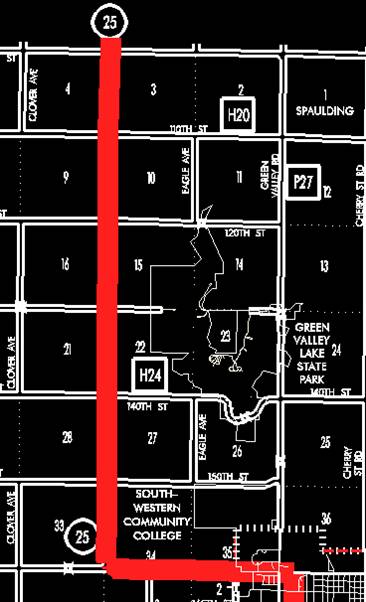
Transfer of
jurisdiction agreement number 2001-16-083, between Creston and the Iowa Department
of Transportation, transferred that portion of Iowa 25 from the south junction
US 34 to the north junction of Iowa 25 (New York Avenue) to city jurisdiction
on December 17, 2001.
PROPOSAL/ACTION
RECOMMENDATION:
New
Description ‑
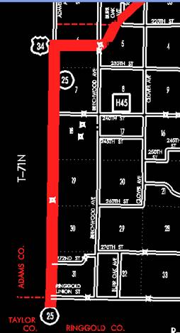
Beginning
at a point near the SW Corner Section 31‑T71N‑R31W Union County (NW
Corner Section 6‑T70N‑R31W Ringgold County) (NE Corner Section 1‑T70N‑R32W
Taylor County) (SE Corner Section 36‑T71N‑R32W Adams County); then
north along the Union‑Adams County line following substantially the
section line of Sections 31, 30, 19, 18, 7 and 6‑T71N‑R31W to a
point approximately 2,600 feet north of the SW Corner Section 6‑T71N‑R31W
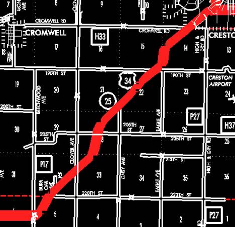
(west junction US 34); then east following substantially the center section
line said Section 6 to a point near the E ¼ Corner Section 6‑T71N‑R31W;
then curving in a northeasterly direction through Section 5‑T71N‑R31W
and Sections 32, 33, 28, 21, 22 and 15‑T72N‑R31W to a point
approximately ¼ mile north of the SE Corner Section 15-T72N-R31W; then in a
northerly and northeasterly direction through Section 14‑T72N‑R31W
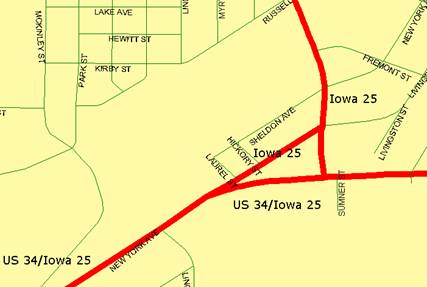
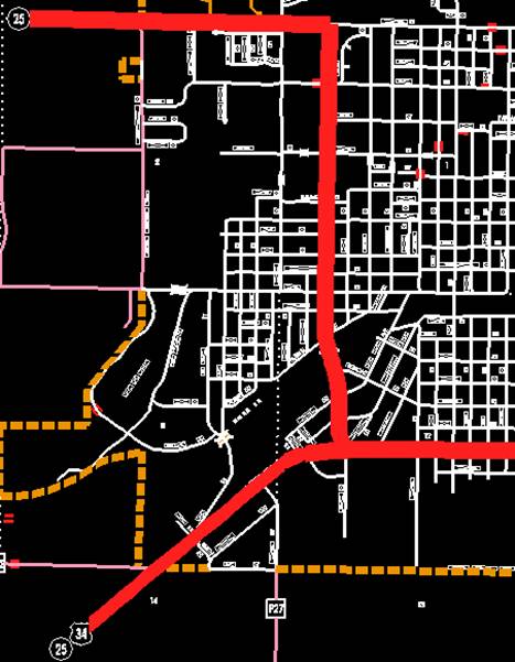
to the south corporation line of Creston, connecting with New York Avenue.
Creston:
Beginning on
Beginning
again on the west corporation line of Creston connecting with
OFFICIAL
DESCRIPTION CHANGE
COUNTY:
ROUTE:
STAFF
ACTION NUMBER: S-87-1507
APPROVAL
DATE: 5-13-87
New
Description ‑
Beginning
at a point near the SW Corner Section 31‑T71N‑R31W Union County (NW
Corner Section 6‑T70N‑R31W Ringgold County) (NE Corner Section 1‑T70N‑R32W
Taylor County) (SE Corner Section 36‑T71N‑R32W Adams County); then
north along the Union‑Adams County line following substantially the
section line of Sections 31, 30, 19, 18, 7 and 6‑T71N‑R31W to a
point approximately 2,600 feet north of the SW Corner Section 6‑T71N‑R31W
(west junction US 34); then east following substantially the center section
line said Section 6 to a point near the E ¼ Corner Section 6‑T71N‑R31W;
then curving in a northeasterly direction through Section 5‑T71N‑R31W
and Sections 32, 33, 28, 21, 22 and 15‑T72N‑R31W to a point
approximately ¼ mile north of the SE Corner Section 15-T72N-R31W; then in a
northerly and northeasterly direction through Section 14‑T72N‑R31W
to the south corporation line of Creston, connecting with New York Avenue.
Creston:
Beginning on
Beginning
again on the west corporation line of Creston connecting with
COMMISSION
ORDER
DIVISION:
Planning & Research
COMMISSION
ORDER NUMBER:
PR-79-272
SUBMITTED
BY: C.I. MacGillivray
MEETING
DATE: 11-2-78
TITLE:
DISCUSSION/BACKGROUND:
Due
to a review of our Primary Road System Records Iowa 25 in
PROPOSAL/ACTION
RECOMMENDATION:
It
is recommended that the old description of
Locate
Beginning
at a point near the SW Corner Section 31‑T71N‑R31W Union County (NW
Corner Section 6‑T70N‑R31W Ringgold County) (NE Corner Section 1‑T70N‑R32W
Taylor County) (SE Corner Section 36‑T71N‑R32W Adams County);
thence north along the Union‑Adams County line following substantially
the section line of Sections 31, 30, 19, 18, 7, and 6‑T71N‑R31W to
a point approximately 2600 feet north of the SW Corner Section 6-T71N-R31W
(west junction US 34); thence easterly following substantially the center
section line said Section 6 to a point near the E ¼ Corner Section 6‑T71N‑R31W;
thence curving in a northeasterly direction through Section 5‑T71N‑R31W
to a point on the west side of the Burlington Northern Railroad approximately
400 feet north and 900 feet east of the E ¼ Corner Section 6‑T71N‑R31W;
thence in a northeasterly direction along the west side of said railroad and
substantially parallel thereto through Section 5‑T71N‑R31W and
Sections 32, 33, 28, 21, 22, and 15‑T72N-R31W to a point approximately ¼
mile north of the SE Corner Section 15‑T72N‑R31W; thence in a
northerly and northeasterly direction through Section 14‑T72N‑R31W
to the south corporation line of the City of Creston connecting with an unnamed
street.
Creston:
Beginning
on the south corporation line connecting with an unnamed street; thence
northeasterly, northerly, and westerly to the west corporation line connecting
with an unnamed street.
Beginning
again on the west corporation line of the City of
REVISED: 5-13-87
OFFICIAL
DESCRIPTION CHANGE
COUNTY:
ROUTE:
APPROVAL
DATE: 5-29-63
Beginning
at a point near the SW Corner Section 31‑T71N‑R31W
Beginning
again on the west corporation line of the City of Creston connecting with Town
Line Street; thence west following substantially the section line to a point
approximately 600 feet east of the SW Corner Section 34‑T73N-R31W; thence
curving in a northwesterly direction to a point approximately 600 feet north of
the SW Corner Section 34‑T73N‑R31W; thence north following
substantially the section line to the Union‑Adair County line at a point
near the NW Corner Section 3‑T73N‑R31W Union County (SW Corner
Section 34‑T74N‑R31W Adair County).
REVISED: 6-13-74
OFFICIAL
DESCRIPTION CHANGE
COUNTY:
CITY
OF: Creston
ROUTE:
APPROVAL
DATE: 12-8-36
Commencing
on New York Avenue at the south corporation line; thence northeasterly on New
York Avenue to Summer Avenue; thence northerly on Summer Avenue to a point
approximately 400 feet north of Prairie Street; thence northwesterly to Town
Line Street; thence west on Town Line Street to the west corporation line.
Also
A
connecting street which extends 650 feet between
REVISED: 6-13-74