OFFICIAL
DESCRIPTION CHANGE
OFFICE:
Transportation Data
EFFECTIVE DATE: 07-01-2003
ENTERED
BY: Stefani Wonders
ENTERED
DATE: 02-07-2005
DISCUSSION/BACKGROUND:
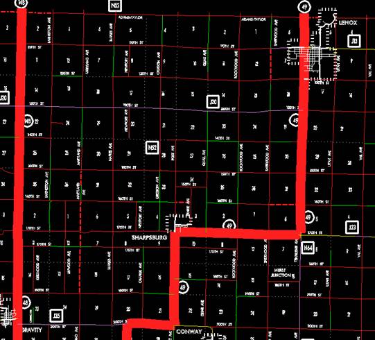
Transfer of jurisdiction agreement number
2003-TJ-036, between Taylor County and the Iowa Department of Transportation,
transferred that portion of Iowa 49 from a
point approximately 425 feet south and 50 feet west of the NE Corner Section 26‑T68N‑R34W
(junction Iowa 2); then northeasterly through Sections 26, 25 24, and 13‑T68N‑R34W
to a point approximately 760 feet south of the NE Corner of Section 13‑T68N‑R34W;
then northeasterly through Sections 7 and 6‑T68N‑R33W to a point
approximately 2690 feet north of the SE Corner Section 6‑T68N‑R33W;
then north following substantially the section line of Section 5‑T68N‑R33W
to a point approximately 300 feet south of the NW Corner Section 5‑T68N‑R33W;
then curving northeasterly to a point approximately 250 feet east of the NW
Corner Section 5‑T68N‑R33W; then east following substantially the
section line said Section 5 to a point approximately 470 feet west of the N ¼
Corner Section 5‑T68N‑R33W; then curving northeast through Section
32‑T69N‑R33W to a point approximately 400 feet north of the S ¼
Corner said Section 32; then north following substantially the center section
line of Sections 32 and 29‑T69N‑R33W to a point near the N ¼ Corner
Section 29‑T69N‑R33W; then east following substantially the north
section line of Sections 29 and 28‑T69N‑R33W to a point near the NW
Corner Section 27‑T69N‑R33W; then northerly following substantially
the west section line of Sections 22, 15, 10‑T69N‑R33W to a point
near the NW Corner Section 10‑T69N‑R33W; then east following substantially
the section line of Sections 10, 11 and 12‑T69N‑R33W and Section 7‑T69N‑R32W
to a point approximately 480 feet west of the SE Corner Section 6‑T69N‑R32W;
then curving in a northeasterly direction to a point approximately 500 feet
north of the SE Corner said Section 6; then north following substantially the
section line of Section 5‑T69N‑R32W and Sections 32, 29, 20, 17 and
8‑T70N‑R32W to the south corporation line of Lenox, connecting with
Brooks Street (approximately 2640 feet north of the SW Corner of said Section
8) to county jurisdiction on July 1, 2003.
Transfer
of jurisdiction agreement number 2003-TJ-037, between the City of Lenox and the
Iowa Department of Transportation, transferred that portion of Iowa 49 from
Brooks Street at the south corporation line; then north on Brooks Street to the
north corporation line (near the SW Corner of Section 5-T70N-R32W) to city
jurisdiction on July 1, 2003.
Transfer of jurisdiction agreement
number 2003-TJ-036, between Taylor County and the Iowa Department of
Transportation, transferred that portion of Iowa 49 from the north
corporation line of Lenox connecting with Brooks Street; then north following
substantially the section line of Section 5‑T70N‑R32W to the Taylor‑Adams
County line at a point near the NW Corner Section 5‑T70N‑R32W,
Taylor County (SW Corner Section 32‑T71N‑R32W, Adams County) to
county jurisdiction on July 1, 2003.

OFFICIAL
DESCRIPTION CHANGE
COUNTY:
ROUTE:
STAFF
ACTION NUMBER: S-87-1508
APPROVAL
DATE: 5-13-87
New
Description ‑
Beginning
at a point approximately 425 feet south and 50 feet west of the NE Corner
Section 26‑T68N‑R34W (junction Iowa 2); then northeast through
Sections 26, 25 and 24‑T68‑R34W to a point approximately 1,300 feet
west of the SE Corner of Section 13‑T68N‑R34W; then northeasterly
through Section 13‑T68N‑R34W and Section 7‑T68N‑R33W to
a point approximately 1,200 feet east of the NW Corner Section 7‑T68N‑R33W;
then northeasterly through Section 6‑T68N‑R33W to a point near the
E ¼ Corner said Section 6; then north following substantially the section line
of Section 5‑T68N‑R33W to a point approximately 600 feet south of
the NW Corner Section 5‑T68N‑R33W; then curving northeasterly to a
point approximately 600 feet east of the NW Corner Section 5‑T68N‑R33W;
then east following substantially the section line said Section 5 to a point
approximately 600 feet west of the N ¼ Corner Section 5‑T68N‑R33W;
then curving northeast through Section 32‑T69N‑R33W to a point
approximately 600 feet north of the S ¼ Corner said Section 32; then north
following substantially the center section line of Sections 32 and 29‑T69N‑R33W
to a point approximately 200 feet south of the N ¼ Corner Section 29‑T69N‑R33W;
then curving northeast through said Section 29 to a point approximately 2,400
feet west of the NE Corner said Section 29; then east following substantially
the section line of Sections 29, 28 and 27‑T69N‑R33W; to a point
approximately 250 feet east of the NW Corner Section 27‑T69N‑R33W;
then northerly through Section 22‑T69N‑R33W to a point
approximately 3,750 feet south of the NW Corner said Section 22; then north
following substantially the section line of Sections 22, 15 and 10‑T69N‑R33W
to a point near the NW Corner Section 10‑T69N‑R33W; then east
following substantially the section line of Sections 10, 11 and 12‑T69N‑R33W
and Section 7‑T69N‑R32W to a point approximately 750 feet west of
the SE Corner Section 6‑T69N‑R32W; then curving in a northeasterly
direction to a point approximately 750 feet north of the SE Corner said Section
6; then north following substantially the section line of Section 5‑T69N‑R32W
and Sections 32, 29, 20, 17 and 8‑T70N‑R32W to the south
corporation line of Lenox, connecting with Brooks Street.
Lenox:
Beginning
on
Beginning
again on the north corporation line of Lenox connecting with
COMMISSION
ORDER
DIVISION:
Planning & Research
COMMISSION
ORDER NUMBER:
PR-80-651
SUBMITTED
BY: Leland D. Smithson
MEETING
DATE: 5-27-80
DISCUSSION/BACKGROUND:
Due
to a relocation of
In
accordance with an agreement between the Iowa State Highway Commission, the
Taylor County Board of Supervisors, and the City of
That
portion of old Iowa 49 from the east corporation line of the City of Bedford
northeasterly to a point approximately 425 feet south and 50 feet west of the
NE Corner Section 26‑T68N‑R34W (junction of relocated Iowa 2) shall
revert to the Taylor County secondary road system.
That
portion of old
Relocated
PROPOSAL/ACTION
RECOMMENDATION:
It is recommended that the present description of
Locate
on the primary road system
Beginning
at a point approximately 425 feet south and 50 feet west of the NE Corner
Section 26‑T68N‑R34W (junction Iowa 2); thence northeasterly
through Sections 26, 25, and 24‑T68N‑R34W to a point approximately
1,300 feet west of the SE Corner of Section 13‑T68N‑R34W; thence
northeasterly through Section 13‑T68N‑R34W and Section 7‑T68N‑R33W
to a point approximately 1,200 feet east of the NW Corner Section 7T68N‑R33W;
thence northeasterly through Section 6‑T68N‑R33W to a point near
the E ¼ Corner said Section 6; thence northerly following substantially the
section line of Section 5‑T68N‑R33W to a point approximately 600
feet south of the NW Corner Section 5‑T68N‑R33W; thence curving
northeasterly to a point approximately 600 feet east of the NW Corner Section 5‑T68N‑R33W
thence easterly following substantially the section line said Section 5 to a
point approximately 600 feet west of the N ¼ Corner Section 5‑T68N‑R33W;
thence curving northeasterly through Section 32‑T69N‑R33W to a
point approximately 600 feet north of the S ¼ Corner said Section 32; thence
northerly following substantially the center section line of Sections 32 and
29-T69N‑R33W to a point approximately 200 feet south of the N ¼ Corner
Section 29-T69N-R33W; thence curving northeasterly through said Section 29 to a
point approximately 2,400 feet west of the NE Corner said Section 29; thence
easterly following substantially the section line of Sections 29, 28, and 27‑T69N‑R33W
to a point approximately 250 feet east of the NW Corner Section 27‑T69N‑R33W;
thence northerly through Section 22‑T69N‑R33W to a point
approximately 3,750 feet south of the NW Corner said Section 22; thence
northerly following substantially the section line of Sections 22, 15, and 10‑T69N‑R33W
to a point near the NW Corner Section 10‑T69N‑R33W; thence easterly
following substantially the section line of Sections 10, 11, and 12-T69N-R33W
and Section 7‑T69N‑R32W to a point approximately 750 feet west of
the SE Corner Section 6‑T69N‑R32W; thence curving in a
northeasterly direction to a point approximately 750 feet north of the SE
Corner said Section 6; thence northerly following substantially the section
line of Section 5‑T69N‑R32W and Sections 32, 29, 20, 17, and 8‑T70N‑R32W
to the south corporation line of the City of Lenox connecting with an unnamed
street.
Lenox:
Beginning on the south corporation line connecting with
an unnamed street; thence northerly to the north corporation line connecting
with an unnamed street.
Beginning
again on the north corporation line of the City of
REVISED: 5-13-87
COMMISSION
ORDER
DIVISION:
Planning & Research
COMMISSION
ORDER NUMBER:
PR-79-272
SUBMITTED
BY: C.I. MacGillivray
MEETING
DATE: 11-2-78
DISCUSSION/BACKGROUND:
Due
to a review of our Primary Road System Records Iowa 49 in
PROPOSAL/ACTION
RECOMMENDATION:
It
is recommended that the old description of
Locate
on the
Beginning
on an unnamed street at
Beginning
at a point on the east corporation line of the City of Bedford, connecting
with an unnamed street at a point on the north side of the Burlington Northern
Railroad; thence northeasterly along the north side and substantially parallel
to the Burlington Northern Railroad through Sections 26, 25, and 24‑T68N‑R34W
to a point approximately 1300 feet west of the SE Corner of Section 13‑T68N‑R34W;
thence northeasterly through Section 13‑T68N‑R34W and Section 7‑T68N‑R33W
to a point approximately 1200 feet east of the NW Corner Section 7‑T68N‑R33W;
thence northeasterly through Section 6‑T68N‑R33W to a point near
the E ¼ Corner said Section 6; thence northerly following substantially the
section line of Section 5‑T68N‑R33W to a point approximately 600
feet south of the NW Corner Section 5‑T68N‑R33W; thence curving
northeasterly to a point approximately 600 feet east of the NW Corner Section 5‑T68N‑R33W
thence easterly following substantially the section line said Section 5 to a
point approximately 600 feet west of the N ¼ Corner Section 5‑T68N‑R33W;
thence curving northeasterly through Section 32‑T69N‑R33W to a
point approximately 600 feet north of the SE Corner said Section 32; thence
northerly following substantially the center section line of Sections 32 and 29‑T69N‑R33W
to a point approximately 200 feet south of the N ¼ Corner Section 29‑T69N‑R33W;
thence curving northeasterly through said Section 29 to a point approximately
2400 feet west of the NE Corner said Section 29; thence easterly following
substantially the section line of Sections 29, 28, and 27‑T69N‑R33W
to a point approximately 250 feet east of the NW Corner Section 27‑T69N‑R33W;
thence northerly through Section 22‑T69N‑R33W to a point
approximately 3750 feet south of the NW Corner said Section 22; thence
northerly following substantially the section line of Sections 22, 15 and 10‑T69N‑R33W
to a point near the NW Corner Section 10‑T69N‑R33W; thence easterly
following substantially the section line of Sections 10, 11, and 12‑T69N‑R33W
and Section 7‑T69N‑R32W to a point approximately 750 feet west of
the SE Corner Section 6‑T69N‑R32W; thence curving in a
northeasterly direction to a point approximately 750 feet north of the SE
Corner said Section 6; thence northerly following substantially the section
line of Section 5‑T69N‑R32W and Sections 32, 29, 20, 17, and 8‑T70N‑R32W
to the south corporation line of the City of Lenox connecting with an unnamed
street.
Lenox:
Beginning
on the south corporation line connecting with an unnamed street; thence
northerly to the north corporation line connecting with an unnamed street.
Beginning
again on the north corporation line of the City of
REVISED
5-27-80
OFFICIAL
DESCRIPTION CHANGE
COUNTY:
ROUTE:
COMMISSION
ORDER NUMBER:
APPROVAL
DATE: 4-12-61
Beginning
at a point on the east corporation line of the City of Bedford, connecting with
an unnamed street at a point on the north side of the Chicago, Burlington &
Quincy Railroad near North Street; thence northeasterly along the north side
and substantially parallel to the Chicago, Burlington & Quincy Railroad
through Sections 26 and 24‑T68N‑R34W to a point near the SE Corner
SW ¼ SE ¼ Section 13‑T68N‑R34W; thence northeasterly through
Section 13‑T68‑R34W and Section 7‑T68N‑R33W to a point
approximately 1,200 feet east of the NW Corner Section 7‑T68N‑R33W;
thence northeasterly to a point near the E ¼ Corner Section 6‑T68N‑R33W;
thence north substantially following the section line to a point near the NW
Corner Section 5‑T68N‑R33W; thence east substantially following the
section line to a point near the N ¼ Corner Section 5‑T68N‑R33W;
thence northerly through Sections 32 and 29‑T69N‑R33W to a point
near the N ¼ Corner Section 29‑T69N‑R33W; thence easterly to the SW
Corner Section 22‑T69N‑R33W; thence northerly approximately three
miles substantially following the section line to a point at or near the NW
Corner Section 10‑T69N‑R33W in the south corporation line of the
Town of Sharpsburg; thence easterly to a point approximately ¼ mile west of the
SE Corner Section 6‑T69N‑R32W; thence curving in a northeasterly
direction to a point approximately ¼ mile north of the SE Corner Section 6‑T69N‑R32W;
thence northerly following substantially the section line to the south
corporation line of the Town of Lenox, connecting with Brook Street.
Beginning
again on the north corporation line of the Town of
OFFICIAL
DESCRIPTION CHANGE
COUNTY:
CITY
OF: Lenox
ROUTE:
COMMISSION
ORDER NUMBER:
APPROVAL
DATE: 11-3-43
Beginning
at the south corporation line connecting with
OFFICIAL
DESCRIPTION CHANGE
COUNTY:
CITY
OF:
ROUTE:
APPROVAL
DATE: 10-13-37
Commencing
at the intersection of
Note: