OFFICIAL
DESCRIPTION CHANGE
OFFICE:
Transportation Data
ENTERED
BY: Stefani Wonders
ENTERED
DATE: 09-19-2006
DISCUSSION/BACKGROUND:
Due to a review
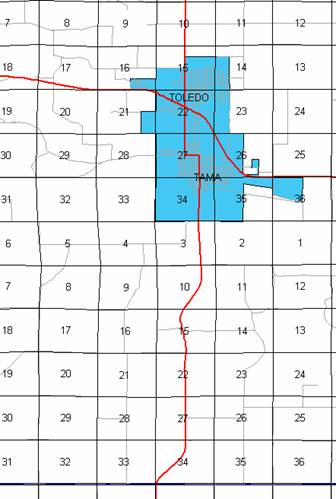
of our Primary System records, the primary route description for US 63 in Tama
County was revised.
PROPOSAL/ACTION
RECOMMENDATION:
New
Description - US 63 and its extensions in
Beginning
on the Tama‑Poweshiek County line at a point near the SW Corner Section
34‑T82N‑R15W, Tama County (NW Corner Section 3‑T81N‑R15W,
Poweshiek County); thence in a northeasterly direction through Section 34‑T82N‑R15W
to a point approximately 794 feet south of the N ¼ Corner said Section 34;
thence northerly following substantially the center section line of Sections
34, 27, 22 and 15‑T82N‑R15W to a point approximately 500 feet north
of the S ¼ Corner Section 15‑T82N‑R15W; thence northwesterly,
northerly and northeasterly through Sections 15 and 10‑T82N‑R15W to
a point approximately 500 feet south of the center of the NE ¼ Section 10‑T82N‑R15W;
thence northerly following substantially the east quarter section line of
Section 10 and 3‑T82N‑R15W to the south corporation line of Tama
connecting with State Street (approximately 1929 feet west of the NE Corner of
said Section 3).
Tama:
Beginning on State Street at the south corporation line;
thence northerly on State Street to 13th Street; thence westerly
on 13th Street to Harding Street; thence northerly on Harding Street to the north corporation
line/south corporation line of Toledo connecting with South County Road (point
near the N ¼ Corner Section 27-T83N-R15W).
Beginning
on
Beginning
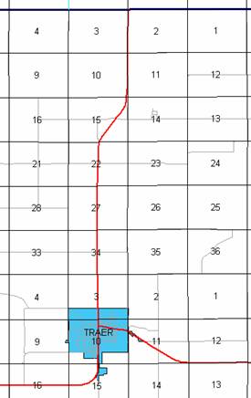
again an the north corporation line of Toledo connecting with South County Road;
thence northerly following substantially the center section line of Sections
15, 10 and 3‑T83N‑R15W, Sections 34, 27, 22, 15, 10 and 3‑T84N‑R15W
and Sections 34, 27, 22 and 15‑T85N‑R15W to a point near the Center
of Section 15‑T85N‑R15W (junction Iowa 96); thence easterly
following substantially the center section line of Sections 15, 14 and 13‑T85N‑R15W
and Sections 18, 17, 16 and 15‑T85N‑R14W to a point approximately
1,400 feet west of the center of Section 15‑T85N‑R14W; thence
curving northeast through said Section 15 to a point approximately 1,400 feet
north of the center said Section 15; thence north following substantially the
center section line of Sections 15 and 10‑T85N‑R14W to the south
corporation line of Traer connecting with Main Street (approximately 1364 feet
north of the S ¼ Corner of said Section 10).
Traer:
Beginning
on
Beginning
again on the north corporation line of Traer connecting with Main Street;
thence northerly following substantially the center section line of Section 3‑T85N‑R14W
and Sections 34, 27, and 22‑T86N‑R14W to a point near the N ¼
Corner of said Section 22; thence northeasterly through Section 15‑T86N‑R14W
to a point approximately 800 feet south of the NE Corner of said Section 15;
thence northerly following substantially the east line of Sections 15, 10 and
3-T86N‑R14W to the Tama‑Black Hawk County line at a point near the
NE Corner Section 3‑T86N‑R14W, Tama County (SE Corner Section 34‑T87N‑R14W,
Black Hawk County).
OFFICIAL
DESCRIPTION CHANGE
COUNTY:
Tama
ROUTE:
US 63
STAFF
ACTION NUMBER: S-87-1509
APPROVAL
DATE: 5-13-87
New
Description - US 63 and its extensions in
Beginning
on the Tama‑Poweshiek County line at a point near the SW Corner Section
34‑T82N‑R15W,
Tama:
Beginning on
Beginning
on
Beginning
again an the north corporation line of Toledo connecting with Park Street;
thence north following substantially the center section line of Sections 15, 10
and 3‑T83N‑R15W, Sections 34, 27, 22, 15, 10 and 3‑T84N‑R15W
and Sections 34, 27, 22 and 15‑T85N‑R15W to a point approximately
75 feet west of the center of Section 15‑T85N‑R15W (junction Iowa
96); thence east following substantially the center section line of Sections
15, 14 and 13‑T85N‑R15W and Sections 18, 17, 16 and 15‑T85N‑R14W
to a point approximately 1,400 feet west of the center of Section 15‑T85N‑R14W;
thence curving northeast through said Section 15 to a point approximately 1,400
feet north of the center said Section 15; thence north following substantially
the center section line of Sections 15 and 10‑T85N‑R14W to the
south corporation line of Traer, connecting with
Traer:
Beginning
on
Beginning
again on the north corporation line of Traer connecting with Main Street;
thence north following substantially the center section line of Section 3‑T85N‑R14W
and Sections 34, 27, 22 and 15‑T86N‑R14W to a point approximately
600 feet north of the S ¼ Corner Section 15‑T86N‑R14W; thence
northeast through Section 15‑T86N‑R14W to a point approximately 800
feet south of the NE Corner said Section 15; thence north following
substantially the east line of Sections 15 and 10‑T86N‑R14W to a
point approximately 1,300 feet south of the NE Corner Section 10‑T86N‑R14W;
thence north following substantially the section line of Sections 11 and 2‑T86N‑R14W
to the Tama‑Black Hawk County line at a point near the NW Corner Section
2‑T86N‑R14W,
COMMISSION
ORDER
DIVISION:
Planning & Research
COMMISSION
ORDER NUMBER:
PR-79-272
SUBMITTED
BY: C.I. MacGillivray
MEETING
DATE: 11-2-78
DISCUSSION/BACKGROUND:
US
63 begins on the Tama‑Poweshiek County line approximately 7 miles south
of Tama, and travels generally northerly, easterly and northerly via Tama,
Due
to a review of our Primary Road System Records US 63 in
PROPOSAL/ACTION
RECOMMENDATION:
It
is recommended that the old description of US 63 in
Locate
U.S 63 and its extensions in
Beginning
on the Tama‑Poweshiek County line at a point near the SW Corner Section
34T82N‑R15W,
Tama:
Beginning on the south corporation
line connecting with an unnamed street; thence northerly, westerly, and
northerly to the north corporation line/south corporation line of the City of
Beginning
on the south corporation line (north corporation line of the City of
Beginning
again on the north corporation line of the City of Toledo connecting with an unnamed
street; thence northerly following substantially the center section line of
Sections 15, 10, and 3‑T83N‑R15W, Sections 34, 27, 22, 15, 10, and
3‑T84N‑R15W and Sections 34, 27, 22, and 15‑T85N‑R15W
to a point approximately 75 feet west of the center of Section 15‑T85N‑R15W
(junction Iowa 96); thence easterly following substantially the center section
line of Sees. 15, 14, and 13‑T85N‑R15W and Sections 18, 17, 16, and
15‑T85N‑R14W to a point approximately 1400 feet west of the center
of Section 15‑T85N‑R14W; thence curving northeasterly through said
Section 15 to a point approximately 1400 feet north of the center said Section
15; thence northerly following substantially the center section line of
Sections 15 and 10‑T85N‑R14W to the south corporation line of the
City of Traer connecting with an unnamed street.
Traer:
Beginning
on the south corporation line connecting with an unnamed street; thence
northerly to the north corporation line connecting with an unnamed street.
Beginning
again on the north corporation line of the City of
REVISED:
5-13-87
OFFICIAL
DESCRIPTION CHANGE
COUNTY:
Tama
ROUTE:
US 63
APPROVAL
DATE: 4-14-37
Beginning
on the Tama‑Poweshiek County line at a point near the SW Corner Section
34‑T82N‑R15W, Tama County, (NW Corner Section 3‑T81N‑R15W,
Poweshiek County); thence in a northeasterly direction to a point approximately
¼ mile south of the N ¼ Corner Section 34‑T82N‑R15W; thence north
following substantially the quarter section line to a point approximately 500
feet north of the S ¼ Corner of Section 15-T82N‑R15W; thence in a
northerly and northeasterly direction through Section 15 and 10‑T82N‑R15W
to a point approximately ¼ mile east and 800 feet north of the center of Section
10-T82N‑R15W; thence north following substantially the east quarter‑quarter
line of Section 10 and 3‑T82N‑R15W, to the south corporation line
of the City of Tama, connecting with State Street.
Beginning
again on the north corporation line of the Town of Toledo, connecting with Park
Street; thence north following substantially the quarter section line to a
point approximately 700 feet south of the center of Section 15‑T82N‑R15W;
thence curving in a northeasterly direction to a point approximately 700 feet
east of the center of Section 15‑T85‑R15; thence east following
substantially the quarter section line to a point approximately 1400 feet west
of the center of Section 15‑T85N-R14W; thence curving in a northeasterly
direction to a point approximately 1400 feet north of the center of Section 15‑T85N‑R14W;
thence north following substantially the quarter section line to the south
corporation line of the Town of Traer, connecting with Main Street.
Beginning
again on the north corporation line of the Town of Traer, connecting with Main
Street; thence north following substantially the quarter section line to a
point approximately 600 feet north of the S ¼ Corner Section 15-T86N‑R14W;
thence in a northeasterly direction to a point approximately 800 feet south of
the NE Corner Section 15-T86N‑R14W; thence north following substantially
the section line to the Tama-Black Hawk County line at a point near the NW
Corner Section 2‑T86N‑R14W Tama County, (SW Corner Section 35‑T87N‑R14W,
Black Hawk County).
OFFICIAL
DESCRIPTION CHANGE
COUNTY:
Tama
CITY
OF:
ROUTE:
US 63
APPROVAL
DATE: 2-5-36
Commencing on
OFFICIAL
DESCRIPTION CHANGE
COUNTY:
Tama
CITY
OF: Tama
ROUTE:
US 63
APPROVAL
DATE: 2-5-36
Commencing
on State Street at the south corporation line; thence northerly on State Street
to Thirteenth Street; thence westerly on Thirteenth Street to Harding Street;
thence northerly on Harding Street to the north corporation line.
OFFICIAL
DESCRIPTION CHANGE
COUNTY:
Tama
CITY
OF: Traer
ROUTE:
US 63
APPROVAL
DATE: 2-5-36
Commencing on