OFFICIAL
DESCRIPTION CHANGE
OFFICE:
Research and Analytics
EFFECTIVE
DATE: 10-9-2019
COUNTY:
Story
ROUTE:
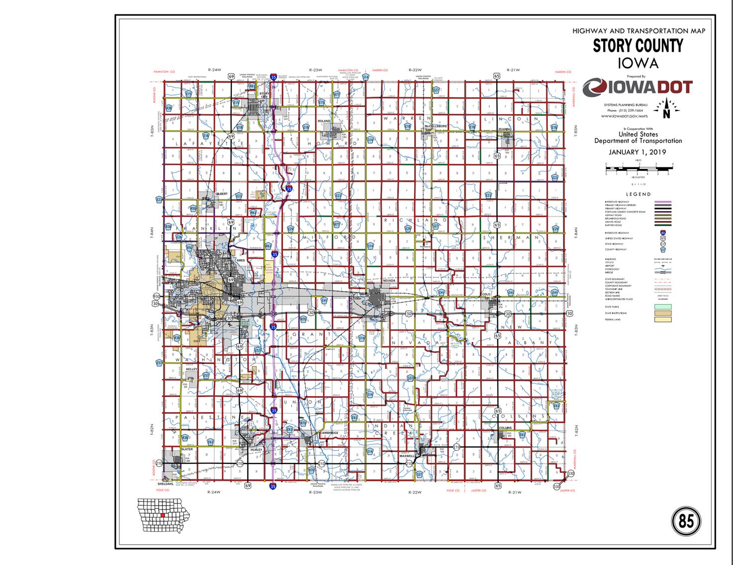
US 30
ENTERED
BY: Paul Mauer
ENTERED
DATE: 12-23-2019
New
Description ‑ US 30 and its extensions in Story County
described as follows:
Beginning
on the Story‑Boone County line at a point approximately 394 feet south of
the W ¼ Corner Section 7‑T83N‑R24W, Story County (E ¼ Corner
Section 12‑T83N‑R25W, Boone County); thence southeast through
Sections 7 and 17‑T83N‑R24W to a point approximately 507 feet south
and 468 feet west of the N ¼ Corner Section 17‑T83N‑R24W; thence
east through Section 17‑T83N‑R24W to the west corporation line of
Ames, connecting with an unnamed street.
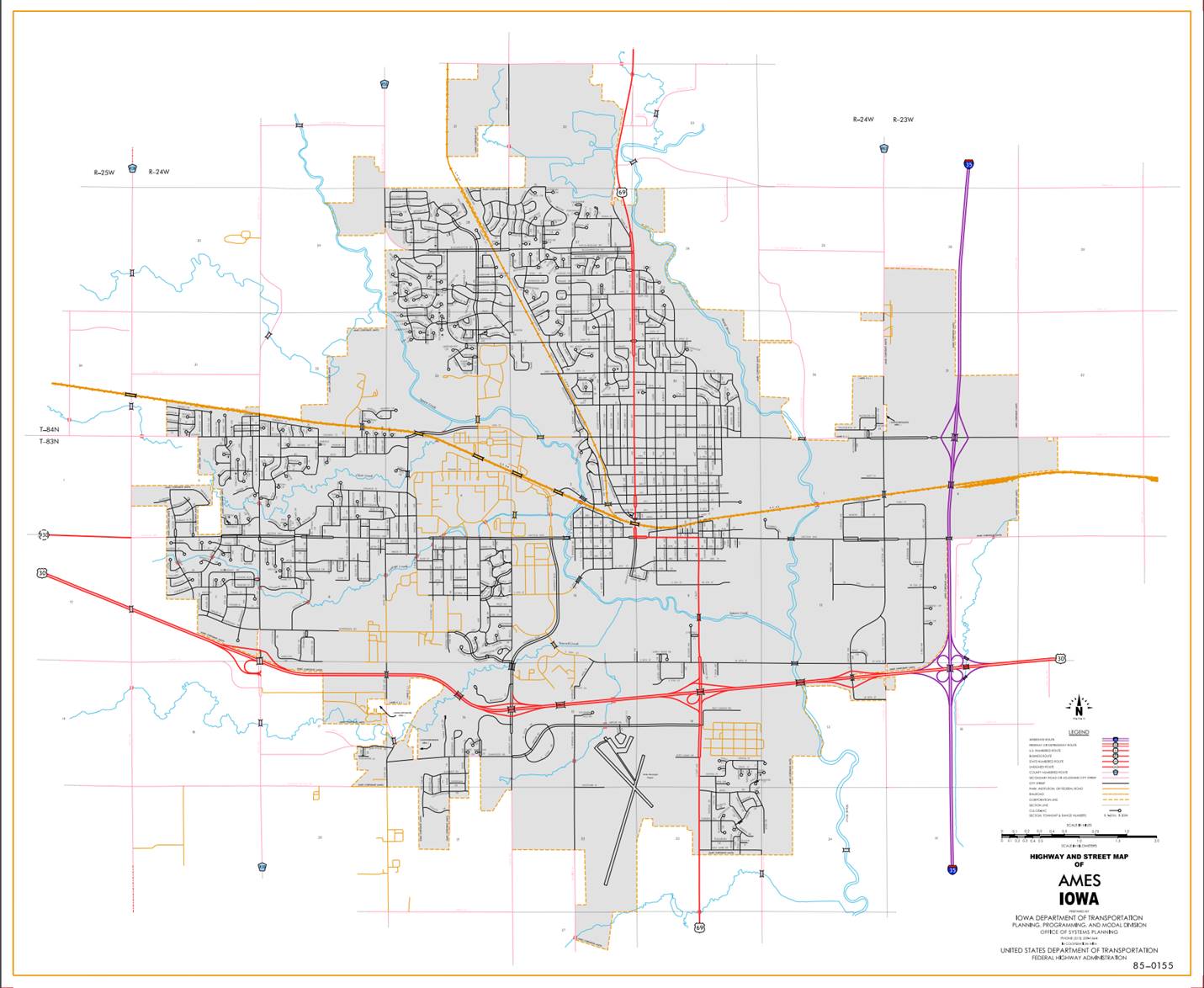
Ames:
Beginning
at the west corporation line; thence east, southeast, east and northeast to the
east corporation line.
Beginning
again at the east corporation line of Ames; thence northeast through Sections
18 (junction Interstate 35), 17 and 8‑T83N‑R23W to a point
approximately 560 feet west and 105 feet north of the S ¼ Corner Section 8‑T83N‑R23W;
thence east following substantially the south line of Sections 8, 9, 10 and 11-
T83N‑R23W to the west corporation line of Nevada.
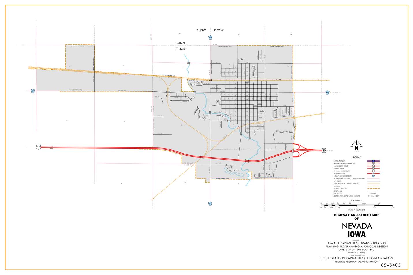
Nevada:
Beginning
at the west corporation line; then east, southeast, east and northeast to the
east corporation line.
Beginning
again on the east corporation line of Nevada; thence east following
substantially the section line through Sections 17 and 16‑T83N‑R22W
to a point approximately 97 feet south of the NE Corner Section 16‑T83N‑R22W;
thence east following substantially the section line through Sections 15, 14
and 13‑T83N‑R22W to a point approximately 1,750 feet east of the NW
Corner Section 13‑T83N‑R22W; thence east through the south part of
Section 12‑T83N‑R22W to a point approximately 91 feet north of the
SE Corner Section 12‑T83N‑R22W; thence east through Sections 7, 8
and 17‑T83N‑R21W to the west corporation line of Colo. thence east
following substantially the section line of Sections 16, 15, 14 and 13‑T83N‑R21W
to the Story‑Marshall County line at a point near the SE Corner Section
12‑T83N‑R21W Story County (SW Corner Section 7‑T83N‑R20W
Marshall County).
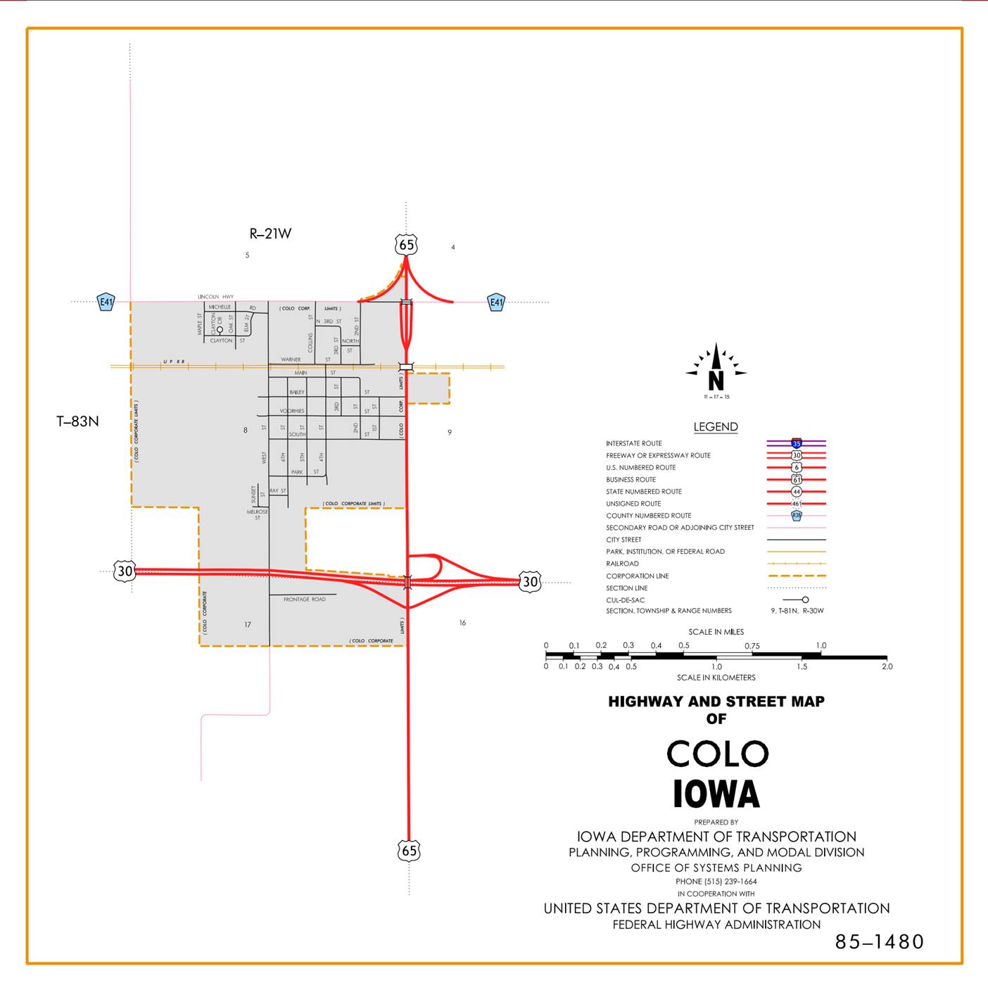
Colo:
Beginning
at the west corporation line; thence east and southeast to the east corporation
line at the junction of US 65.
Beginning
again at the east corporation line of Colo at the junction of US 65; thence
east following substantially the section line of Sections 16, 15, 14 and 13‑T83N‑R21W
to the Story‑Marshall County line at a point near the SE Corner Section
12‑T83N‑R21W Story County (SW Corner Section 7‑T83N‑R20W
Marshall County).
OFFICIAL
DESCRIPTION CHANGE
County: Story
ROUTE: US 30
STAFF
ACTION NUMBER: S-87-1510
APPROVAL
DATE: 5-13-87
New
Description ‑ US 30 and its extensions in Story County
described as follows:
Beginning
on the Story‑Boone County line at a point approximately 394 feet south of
the W ¼ Corner Section 7‑T83N‑R24W, Story County (E ¼ Corner
Section 12‑T83N‑R25W, Boone County); thence southeast through
Sections 7 and 17‑T83N‑R24W to a point approximately 507 feet south
and 468 feet west of the N ¼ Corner Section 17‑T83N‑R24W; thence
east through Section 17‑T83N‑R24W to the west corporation line of
Ames, connecting with an unnamed street.
Ames:
Beginning
on an unnamed street at the west corporation line; thence east and southeast on
an unnamed street to the south corporation line.
Beginning
again on the south corporation line of Ames
connecting with an unnamed street; thence southeast through Section 16‑T83N‑R24W;
to the west corporation line of Ames,
connecting with an unnamed street.
Ames:
Beginning
on an unnamed street at the west corporation line; thence southeast, east and
northeast on unnamed street to the east corporation line.
Beginning
again on the east corporation line of Ames
connecting with an unnamed street; thence northeast through Section 15‑T83N‑R24W
to the west corporation line of Ames,
connecting with an unnamed street.
Ames:
Beginning
on the west corporation line connecting with an unnamed street; thence
northeast to the east corporation line, connecting with an unnamed street.
Beginning
again on the east corporation line of Ames
connecting with an unnamed street; thence northeast through Section 13‑T83N‑R24W
to the west corporation line of Ames,
connecting with an unnamed street.
Ames:
Beginning
on the west corporation line connecting with an unnamed street; thence
northeast to the east corporation line connecting with an unnamed street.
Beginning
again on the east corporation line of Ames connecting with an unnamed street;
thence northeast through Sections 18 (junction Interstate 35), 17 and 8‑T83N‑R23W
to a point approximately 560 feet west and 105 feet north of the S ¼ Corner
Section 8‑T83N‑R23W; thence east following substantially the south
line of Sections 8, 9, 10, 11 and 12‑T83N‑R23W to a point 255 feet
east and 100 feet north of the SW Corner Section 12‑T83N‑R23W;
thence curving southeast through Sections 12 and 13‑T83N‑R23W to
the west corporation line of Nevada, connecting with an unnamed street.
Nevada:
Beginning
on the west corporation line connecting with an unnamed street; thence east to
the east corporation line.
Beginning
again on the east corporation line of Nevada connecting with an unnamed street;
thence curving southeast and northeast through Sections 18 and 17‑T83N‑R22W
to a point approximately 1,010 feet east and 30 feet south of the N ¼ Corner
Section 17‑T83N‑R22W; thence east following substantially the
section line through Sections 17 and 16‑T83N‑R22W to a point
approximately 97 feet south of the NE Corner Section 16‑T83N‑R22W;
thence east following substantially the section line through Sections 15, 14
and 13‑T83N‑R22W to a point approximately 1,750 feet east of the NW
Corner Section 13‑T83N‑R22W; thence east through the south part of
Section 12‑T83N‑R22W to a point approximately 91 feet north of the
SE Corner Section 12‑T83N‑R22W; thence east through Sections 7, 8
and 17‑T83N‑R21W to a point approximately 124 feet south of the NE
Corner Section 17‑T83N‑R21W (junction US 65); thence east following
substantially the section line of Sections 16, 15, 14 and 13‑T83N‑R21W
to the Story‑Marshall County line at a point near the SE Corner Section
12‑T83N‑R21W Story County (SW Corner Section 7‑T83N‑R20W
Marshall County).
COMMISSION
ORDER
DIVISION: Planning & Research
COMMISSION
ORDER NUMBER:
PR-79-272
SUBMITTED
BY: C.I. MacGillivray
MEETING
DATE:
11-2-78
TITLE: US 30, Story
County, Iowa
DISCUSSION/BACKGROUND:
US
30 begins on the Story‑Boone County line approximately 4 ½ miles west and
½ mile south of the center of Ames, and travels generally easterly via Ames and
Nevada to the Story‑Marshall County line approximately 4 ½ miles east and
one mile south of Colo,
Iowa.
Due
to a review of our Primary Road System Records US 30 in Story County
should be deleted and the new description added should be officially included
into the Primary System.
PROPOSAL/ACTION
RECOMMENDATION:
It
is recommended that the old description of US 30 in Story County be deleted and
the new description, as referred in the attached detailed description, be
included in the Primary Road System effective upon the adoption of this
resolution.
Locate
US 30 and its extensions in Story
County as follows:
Beginning
on the Story‑Boone County line at a point approximately 394 feet south of
the W ¼ Corner Section 7‑T83N‑R24W, Story County (E ¼ Corner
Section 12‑T83N‑R25W, Boone County); thence southeasterly through
Sections 7 and 17-T83N‑R24W to a point approximately 507 feet south and
468 feet west of the N ¼ Corner Section 17‑T83N‑R24W; thence
easterly through Section 17-T83N‑R24W to the west corporation line of
the City of Ames connecting with an unnamed street.
Ames:
Beginning
on an unnamed street at the west corporation line; thence east and
southeasterly on an unnamed street to the south corporation line.
Beginning
again on the south corporation line of the City of Ames connecting with an
unnamed street; thence southeasterly through Section 16‑T83N‑R24W
to the west corporation line of the City of Ames connecting with an unnamed
street.
Ames:
Beginning
again on an unnamed street at the west corporation line; thence easterly and
northeasterly on an unnamed street to the east corporation line.
Beginning
again on the east corporation line of the City of Ames connecting with an
unnamed street; thence northeasterly through Section 15‑T83N‑R24W
to the west corporation line of the City of Ames connecting with an unnamed
street.
Ames:
Beginning
on the west corporation line connecting with an unnamed street; thence
northeasterly to the east corporation line connecting with an unnamed street.
Beginning
again on the east corporation line of the City of Ames connecting with an
unnamed street; thence northeasterly through Section 13‑T83N‑R24W
to the west corporation line of the City of Ames connecting with an unnamed
street.
Ames:
Beginning
on the west corporation line connecting with an unnamed street; thence
northeasterly to the east corporation line connecting with an unnamed street.
Beginning
again on the east corporation line of the City of Ames connecting with an
unnamed street: thence northeasterly through Sections 13 (junction Interstate
35), 17, and 8‑T83N‑R23W to a point approximately 560 feet west and
105 feet north of the S ¼ Corner Section 8‑T83N‑R23W; thence
easterly following substantially the south line of Sections 8, 9, 10, 11, and
12‑T83N‑R23W to a point 255 feet east and 100 feet north of the SW
Corner Section 12‑T83N‑R23W; thence curving southeasterly through
Sections 12 and 13‑T83N‑R23W to the west corporation line of the
City of Nevada connecting with an unnamed street.
Nevada:
Beginning
on the west corporation line connecting with an unnamed street; thence easterly
to the east corporation line connecting with an unnamed street.
Beginning
again on the east corporation line of the City of Nevada connecting with an
unnamed street; thence curving southeasterly and northeasterly through Sections
18 and 17‑T83N‑R21W to a point approximately 1010 feet east and 30
feet south of the N ¼ Corner Section 17‑T83N‑R22W; thence easterly
following substantially the section line through Sections 17 and 16‑T83N‑R22W
to a point approximately 97 feet south of the NE Corner Section 16‑T83N‑R22W;
thence easterly following substantially the section line through Sections 15,
14, and 13‑T83N‑R22W to a point approximately 1750 feet east of the
NW Corner Section 13‑T83N‑R22W; thence easterly through the south
part of Section 12-T83N-R22W to a point approximately 91 feet north of the SE
Corner Section 12-T83N-R21W; thence easterly through Sections 7, 8 and 17‑T83N‑R21W
to a point approximately 124 feet south of the NE Corner Section 17‑T83N‑R21W
(junction US 65); thence easterly following substantially the section line of
Sections 16, 15, 14, and 13‑T83N‑R21W to the Story-Marshall County
line at a point near the SE Corner Sic. 12-T83N‑R21W Story County (SW
Corner Section 7‑T83N-R20W Marshall County).
REVISED: 5-13-87
COMMISSION
RESOLUTION
DIVISION: Planning & Research
COMMISSION
ORDER NUMBER:
74-1026
SUBMITTED
BY: Gene R. Mills
MEETING
DATE:
8-21-74
TITLE: Approving the location of US 30 and its
extension in Story County, Iowa
Locate
US 30 and its extension in Story County, Iowa, as follows:
Beginning
on the Story‑Boone County line at a point approximately 394 feet south of
the W ¼ Corner Section 7‑T83N‑R24W, Story County (E ¼ Corner
Section 12‑T83N‑R25W, Boone County); thence southeasterly through
Section 7-T83N‑R24W to a point approximately 507 feet south and 468 feet
west of the N ¼ Corner Section 17‑T83N‑R24W; thence east to the
west corporation line of the City of Ames connecting with an unnamed street.
Beginning
again on the south corporation line of the City of Ames connecting with an
unnamed street; thence southeasterly, east, and northeasterly through Sections
16 and 15-T83N-R24W to the west corporation line of the City of Ames connecting
with an unnamed street.
Beginning
again on the east corporation line of the City of Ames connecting with an
unnamed street; thence northeasterly through Section 13‑T83N‑R24W
to the west corporation line of the City of Ames connecting with an unnamed
street.
Beginning
again on the east corporation line of the City of Ames connecting with an
unnamed street; thence northeasterly through Sections 18, 17 and 8-T83N-R23W
to a point approximately 560 feet west and 105 feet north of the S ¼ Corner
Section 8-T83N‑R23W; thence easterly following substantially the section
line through Sections 8, 9, 10, 11 and 12-T83N-R23W to a point 255 east and 100
feet north of the SW Corner Section 12-T83N-R23W; thence curving southeasterly
and easterly through Sections 12 and 13, T83N-R23W to the west corporation line
of the City of Nevada connecting with an unnamed street.
Beginning
again on the east corporation line of the City of Nevada connecting with an
unnamed street; thence curving northeasterly and easterly through Sections 18
and 17- T83N-R22W to a point approximately 1,010 feet east and 30 feet south of
the N ¼ Corner Section 17‑T83N‑R22W; thence easterly following substantially
the section line through Sections 17 and 16‑T83N‑R22W to a point
approximately 97 feet south of the NE Corner Section 16-T83N‑R22W;
thence easterly following substantially the section line through Sections 15,
14, 13 and 12‑T83N‑R22W to a point approximately 91 feet north of
the SE Corner Section 12‑T83N‑R22W; thence easterly following
substantially the section line through Sections 7 and 8-T83N-R21W to a point
approximately 90 feet north of the S ¼ Corner Section 8-T83N‑R21W; thence
easterly following substantially the section line through Section 8 and 17-T83N‑R21W
to a point approximately 124 feet south of the NE Corner Section 17-T83N-R21W;
thence easterly following substantially the section line to a point
approximately 17 feet north of the SE Corner Section 12‑T83N‑R21W,
Story County (SW Corner Section 7‑T83N‑R20W, Marshall County).
Nevada
Commencing
on an unnamed street at the west corporation line; thence east on unnamed
street to the east corporation line (Intersection Iowa 133).
NOW,
THEREFORE: Be it resolved that the Iowa State Highway Commission approve the
location of US 30 and its extension in Story County, Iowa.
COMMISSION RESOLUTION
DIVISION: Planning & Research
COMMISSION
ORDER NUMBER:
73-801
SUBMITTED
BY: Gene R. Mills
MEETING
DATE:
6-27-73
TITLE: Approving the revision of the location of US
30 and its extensions in Story
County
Locate
on US 30 and extensions in Story County, Iowa, as follows:
Beginning
on the Story‑Boone County line at a point approximately 394 feet south of
the W ¼ Corner Section 7-T83N‑R24W, Story County (E ¼ Corner Section 12‑T83N‑R25W,
Boone County); thence southeasterly through Section 7-T83N‑R24W to a
point approximately 507 feet south and 468 feet west of the N ¼ Corner Section
17‑T83N‑R24W; thence east to the west corporation line of the City
of Ames connecting with an unnamed street.
Beginning
again on an unnamed street at the west corporation line; thence east and
northeasterly on unnamed street to the east corporation line.
Beginning
again on the south corporation line of the City of Ames connecting with an
unnamed street; thence southeasterly, east, and northeasterly through Sections
16 and 15-T83N-R24W to the west corporation line of the City of Ames connecting
with an unnamed street.
Beginning
again on the east corporation line of the City of Ames connecting with an
unnamed street; thence northeasterly through Section 13‑T83N‑R24W
to the West corporation line of the City of Ames connecting with an unnamed
street.
Beginning
again on the east corporation line of the City of Ames connecting with an
unnamed street; thence northeasterly through Sections 18, 17 and 8-T83N‑R23W
to a point approximately 560 feet west and 105 feet north of the S ¼ Corner
Section 8-T83N‑R23W; thence easterly following substantially the section
line through Sections 8, 9, 10, 11 and 12‑T83N-R23W to a point 255 feet
east and 100 feet north of the SW Corner Section 12-T83N‑R23W; thence
curving southeasterly and easterly through Sections 12 and 13- T83N‑R23W
to a point approximately 735 feet south of the NE Corner Section 13-T83NR22W;
thence easterly through Section 18‑T83N‑R22W to a point
approximately 900 feet east and 825 feet south of the N ¼ Corner Section 18‑T83N‑R22W;
thence curving northeasterly and easterly through Sections 18 and 17-T83N-R22W
to a point approximately 1,010 feet east and 30 feet south of the N ¼ Corner
Section 17‑T83N‑R22W; thence easterly following substantially the
section line through Sections 17 and 16‑T83N‑R22W to a point
approximately 97 feet south of the NE Corner Section 16‑T83N‑R22W;
thence easterly following substantially the section line through Sections 15,
14, 13 and 12‑T83N‑R22W to a point approximately 91 feet north of
the SE Corner Section 12‑T83N‑R22W; thence easterly following
substantially the section line through Sections 7 and 8-T83N‑R21W to a
point approximately 90 feet north of the S ¼ Corner Section 8‑T83N-R21W;
thence easterly following substantially the section line through Section 8 and
17-T83N-R21W to a point approximately 124 feet south of the NE Corner Section
17‑T83N‑R21W; thence easterly following substantially the section
line to a point approximately 17 feet north of the SE Corner Section 12‑T83N‑R21W,
Story County (SW Corner Section 7-T83N‑R20W, Marshall County).
Ames:
Beginning
on an unnamed street at the west corporation line; thence east and
southeasterly on unnamed street to the south corporation line.
NOW,
THEREFORE: Be it resolved that the Iowa State Highway Commission approve the
revision of US 30 and its extensions in Story County, Iowa.
OFFICIAL
DESCRIPTION CHANGE
County: Story
ROUTE: US 30
APPROVAL
DATE: 1-23-63
Beginning
on the Story‑Boone County line at a point approximately 859 feet north of
the W ¼ Corner Section 7‑T83N‑R24W Story County (E ¼ Corner Section
12‑T83N‑R25W Boone County); thence southeasterly, easterly,
southeasterly and northeasterly through Sections 7, 17, 16, 15 and 14‑T83N‑R24W
to a point approximately 1247 feet south of the N ¼ Corner Section 14‑T83N‑R24W;
thence northeasterly through Sections 14 and 13‑T83N‑R24W and
Section 18‑T83N-R23W to a point approximately 270 feet south and 190 feet
west of the N ¼ Corner Section 18‑T83N‑R23W; thence northeasterly
through Sections 18, 17 and 8‑T83N‑R23W to a point approximately
560 feet west and 105 feet north of the S ¼ Corner Section 8‑T83N‑R23W;
thence easterly following substantially the section line through Sections 8, 9,
10, 11 and 12‑T83N‑R23W to a point 255 feet east and 100 feet north
of the SW Corner Section 12‑T83N‑R23W; thence curving southeasterly
and easterly through Sections 12 and 13‑T83N‑R23W to a point
approximately 735 feet south of the NE Corner Section 13‑T83N‑R22W;
thence easterly through Section 18‑T83N‑R22W to a point
approximately 900 feet east and 825 feet south of the N ¼ Corner Section 18‑T83N‑R22W;
thence curving northeasterly and easterly through Sections 18 and 17‑T83N‑R22W
to a point approximately 1010 feet east and 30 feet south of the N ¼ Corner Section
17-T83N‑R22W; thence easterly following substantially the section line
through Sections 17 and 16‑T83N‑R22W to a point approximately 97
feet south of the NE Corner Section 16‑T83N‑R22W; thence easterly
following substantially the section line through Sections 15, 14, 13 and 12‑T83N‑R22W
to a point approximately 91 feet north of the SE Corner Section 12‑T83N‑R22W;
thence easterly following substantially the section line through Sections 7 and
8-T83N‑R21W to a point approximately 90 feet north of the S ¼ Corner
Section 8-T83N‑R21W; thence easterly following substantially the section
line through Section 8 and 17‑T83N‑R21W to a point approximately
124 feet south of the NE Corner Section 17‑T83N‑R21W; thence
easterly following substantially the section line to a point approximately 17
feet north of the SE Corner Section 12‑T83N‑R21W Story County (SW
Corner Section 7-T83N‑R20W Marshall County).
OFFICIAL
DESCRIPTION CHANGE
County: Story
APPROVAL
DATE: 1-7-41
CONNECTING
CURVES
Junction
of US 30 and US 65 east of Colo
Beginning
at a point approximately 1000 feet east of the SW Corner Section 4‑T83N‑R21W;
thence curving in a northwesterly direction to a point approximately 1000 feet
north of the SW Corner Section 4‑T83N‑R21W.
Beginning
at a point approximately 1000 feet west of the SE Corner Section 5‑T83N‑R21W;
thence curving in a northeasterly direction to a point approximately 1000 feet
north of the SE Corner Section 5‑T83N‑R21W.
OFFICIAL
DESCRIPTION CHANGE
County: Story
ROUTE: US 30
APPROVAL
DATE: 4-14-37
Beginning
at a point near the NW Corner Section 7-T83N‑R24W, Story County (NE
Corner Section 12‑T83N‑R25W, Boone County); thence east following
substantially the section line to a point approximately 800 feet west of the NE
Corner Section 7‑T83N‑R24W; thence in a southeasterly, easterly and
northeasterly direction through the north part of Section 7 and 8‑T83N‑R24W,
to a point approximately 700 feet west of the N ¼ Corner Section 8‑T83N‑R24W;
thence east following substantially the section line to the west corporation
line of the City of Ames, connecting with Lincoln Way.
Beginning
again on the east corporation line of the City of Ames, connecting with Lincoln
Way; thence east following substantially the section line to the west
corporation line of the City of Nevada, connecting with Lincoln Way.
Beginning
again on the east corporation line of the City of Nevada, connecting with
Lincoln Way; thence east following substantially the section line to a point
approximately 700 feet west of the N ¼ Corner of Section 10‑T83N‑R22W;
thence in a southeasterly and northeasterly direction through the north part of
Section 10‑T83N‑R22W, crossing the Chicago, Rock Island and Pacific
Railway overpass, and passing through the Chicago and Northwestern Railway
subway to a point near the NE Corner Section 10‑T83N‑R22W; thence
east following substantially the section line to the Story‑Marshall
County line at a point near the NE Corner Section 12‑T83N‑R21W,
Story County (NW Corner Section 7‑T83N‑R20W, Marshall County)
REVISED: 12-23-63
OFFICIAL
DESCRIPTION CHANGE
County: Story
CITY
OF: Ames
ROUTE: US 30
APPROVAL
DATE: 2-5-36
Commencing
on Lincoln Way at the west corporation line; thence easterly on Lincoln Way to
the east corporation line.
OFFICIAL
DESCRIPTION CHANGE
County: Story
CITY
OF: Nevada
ROUTE: US 30
APPROVAL
DATE: 2-5-36
Commencing
on Lincoln Way at the west corporation line; thence easterly on Lincoln Way to
the east corporation line.