OFFICIAL
DESCRIPTION CHANGE
OFFICE:
Research and Analytics
EFFECTIVE
DATE: 8-18-2017
COUNTY:
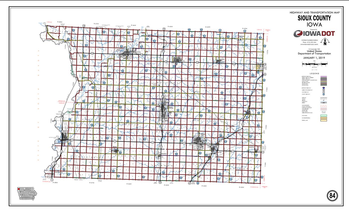
Sioux
ROUTE:
US 75
ENTERED
BY: Paul Mauer
ENTERED
DATE: 12-20-2019
New
Description - US 75 and its extension in Sioux County described as follows
Beginning
on the Sioux‑Plymouth County line at a point near the SW Corner Section
33‑T94N‑R45W, Sioux County, (NW Corner Section 4‑T93N‑R45W,
Plymouth County); thence north following substantially the section line of
Sections 33, 28, 21, 16, 9 and 4‑T94N‑R45W (junction Iowa 10) and
Section 33‑T95N‑R45W to a point on the east side of the Burlington
Northern Railway near the W ¼ Corner Section 33‑T95N‑R45W; thence
in a northeasterly direction along the east side of said railway and
substantially parallel thereto, through Section 33‑T95N‑R45W, and
in a northerly and northwesterly direction through Section 28 and 21‑T95N‑R45W,
to a point approximately ¼ mile north of the SW Corner Section 21‑T95N‑R45W;
thence north following substantially the section line of Sections 21 and 16‑T95N‑R45W
to the south corporation line of Sioux Center, connecting with Main Avenue.
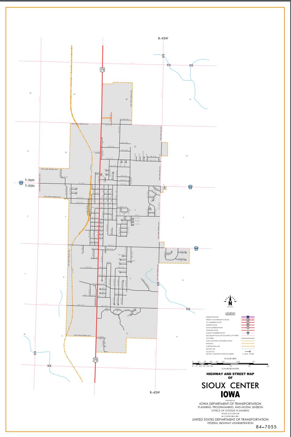
Beginning
on Main Avenue at the south corporation line; thence north on Main Avenue to
North Main Avenue; thence north on North Main Avenue to the north corporation
line.
Beginning
again on the north corporation line of Sioux Center connecting with North Main
Avenue; thence north following substantially the section line of Sections 28,
21, 16, 9 and 4‑T96N‑R45W and Sections 33 and 28‑T97N‑R45W
to a point approximately 500 feet north of the SW Corner Section 28‑T97N‑R45W
(south junction US 18); thence north following substantially the section line
of Section 28‑T97N‑R45W to a point approximately 500 feet south of
the NW Corner said Section 28 (north junction US 18); thence north following
substantially the section line of Sections 28, 21, 16, 9 and 4‑T97N‑R45W
to the Sioux‑Lyon County line at a point near the NW Corner Section 4‑T97N‑R45W,
Sioux County (NW Corner Section 33‑T98N‑R45W, Lyon County).
OFFICIAL
DESCRIPTION CHANGE
COUNTY: Sioux
ROUTE: US 75
STAFF
ACTION NUMBER: S-87-1511
APPROVAL
DATE: 5-13-87
New
Description - US 75 and its extension in
Beginning
on the Sioux‑Plymouth County line at a point near the SW Corner Section
33‑T94N‑R45W,
Beginning
on
Beginning
again on the north corporation line of Sioux Center connecting with North Main
Avenue; thence north following substantially the section line of Sections 33,
28, 21, 16, 9 and 4‑T96N‑R45W and Sections 33 and 28‑T97N‑R45W
to a point approximately 500 feet north of the SW Corner Section 28‑T97N‑R45W
(south junction US 18); thence north following substantially the section line
of Section 28‑T97N‑R45W to a point approximately 500 feet south of
the NW Corner said Section 28 (north junction US 18); thence north following
substantially the section line of Sections 28, 21, 16, 9 and 4‑T97N‑R45W
to the Sioux‑Lyon County line at a point near the NW Corner Section 4‑T97N‑R45W,
Sioux County (NW Corner Section 33‑T98N‑R45W, Lyon County).
COMMISSION
ORDER
DIVISION: Planning & Research
COMMISSION
ORDER NUMBER:
PR-79-272
SUBMITTED
BY: C.I. MacGillivray
MEETING
DATE:
11-2-78
TITLE:
DISCUSSION/BACKGROUND:
US
75 begins on the Sioux‑Plymouth County line approximately 4 miles south
of Maurice, and travels northerly via Sioux Center to the Sioux‑Lyon
County line approximately 5 miles north and 2 miles west of Hull, Iowa.
Due
to a review of our Primary Road System Records US 75 in
PROPOSAL/ACTION
RECOMMENDATION:
It
is recommended that the old description of US 75 in
Locate
US 75 and its extension in
Beginning
on the Sioux‑Plymouth County line at a point near the SW Corner Section
33T94N‑R45W,
Beginning
on the south corporation line connecting with an unnamed street; thence
northerly to the north corporation line connecting with an unnamed street.
Beginning
again on the north corporation line of the City of Sioux Center connecting with
an unnamed street; thence northerly following substantially the section line of
Sections 33, 28, 21, 16, 9, and 4‑T96N‑R45W and Sections 33 and 28‑T97N‑R43W
to a point approximately 500 feet north of the SW Corner Section 28‑T97N‑R47W
(south junction US 18); thence northerly following substantially the section
line of Section 28-T97N-R45W to a point approximately 500 feet south of the NW
Corner said Section 28 (north junction US 18); thence northerly following
substantially the section line of Sections 28, 21, 16, 9, and 4‑T97N‑R45W
to the Sioux‑Lyon County line at a point near the NW Corner Section 4‑T97N‑R45W,
Sioux County (NW Corner Section 33‑T93N‑R45W, Lyon County).
REVISED:
5-13-87
OFFICIAL DESCRIPTION CHANGE
COUNTY: Sioux
APPROVAL
DATE: 2-20-40
CONNECTING
CURVE
South
Junction
Beginning
at a point approximately 700 feet south of the NW Corner of Section 33‑T97N‑R45W;
thence curving in a northeasterly direction to a point approximately 700 feet
east of the NW Corner of Section 33‑T97N-R45W.
OFFICIAL
DESCRIPTION CHANGE
COUNTY: Sioux
APPROVAL
DATE: 4-14-37
CONNECTING
CURVES.
Junction
of
Beginning
at a point approximately 400 feet west of the SE Corner Section 32-T95N‑R45W;
thence curving in a northeasterly direction to a point approximately 460 feet
north of the SE Corner Section 32‑T95N‑R45W.
Beginning
at a point approximately 400 feet north of the SW Corner Section 33‑T95N‑R45W;
thence curving in a southeasterly direction to a point approximately 400 feet
east of the SW Corner Section 33‑T95N‑R45W.
Beginning
at a point approximately 400 feet east of the NW Corner Section 4‑T94N‑R45W;
thence curving in a southwesterly direction to a point approximately 400 feet
south of the NW Corner Section 4‑T94N‑R45W.
Beginning
at a point approximately 400 feet south of the NE Corner Section 5‑T94N‑R45W;
thence curving in a northwesterly direction to a point approximately 400 feet
west of the NE Corner Section 5‑T94N‑R45W.