OFFICIAL
DESCRIPTION CHANGE
OFFICE:
Research and Analytics
EFFECTIVE
DATE: 10-4-2018
COUNTY:
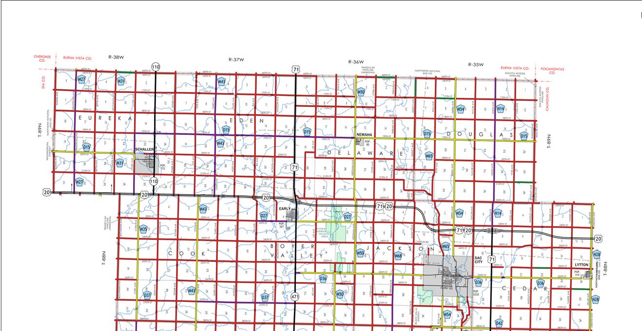
Sac
ROUTE:
US 20
ENTERED
BY: Paul Mauer
ENTERED
DATE: 10-24-2019
New
Description - US 20 and its extensions in
Beginning
on the Sac‑Ida County line at a point near the SW Corner of Section 31‑T89N‑R38W,
Sac County (A point approximately 900 feet east of N ¼ Corner Section 4‑T88N‑R39W,
Ida County); thence easterly along the Sac‑Ida County line to a point
approximately 100 feet north of the SW Corner of Section 34‑T89N‑R38W;
thence easterly following substantially the section line of Sections 35, 36-T88N-R38W
(junction Iowa 110); then continuing east along southern border of Sections 31,
32, 33, 34, 35 and 36-T89N-R37W to the NW Corner of Section 5-T88N-R37W; then southeasterly
through Section 4-T88N‑R37W to a point approximately 850 feet south of NW
Corner of Section 3-T88N-R37W (junction US 71 and Iowa 471); then connecting
with US 71 and continuing southeast and east through Sections 3, 2 and
1-T88N-R37W to the intersection of Needham Avenue; then continuing east
substantially through the section lines of Sections 6, 5 and 4-T88N-R36W; then
curving southeasterly and south through Section 3-T88N-36W; then continuing
southeast through NE Corner of Section 10-T88N-R36W and east through the
section lines of Sections 11 and 12-T88N-R36W to the intersection of Taylor
Avenue; then east through Section 7-T88N-R35W to the junction of US 71 and
Union Avenue; then east substantially through the section lines of sections 8,
9, 10, 11 and 12-T88N-R35W to the intersection of Zeller Avenue (Sac-Calhoun
County Line)
OFFICIAL
DESCRIPTION CHANGE
COUNTY: Sac
ROUTE: US 20
STAFF
ACTION NUMBER: S-87-1514
APPROVAL
DATE: 5-13-87
New
Description - US 20 and its extensions in
Beginning
on the Sac‑Ida County line at a point near the SW Corner of Section 31‑T89N‑R38W,
Sac County (A point approximately 900 feet east of N ¼ Corner Section 4‑T88N‑R39W,
Ida County); thence easterly along the Sac‑Ida County line (see Ida
County) to a point approximately 1,500 feet east of the SW Corner of Section 34‑T89N‑R38W,
Sac County (NE Corner of Section 1‑T88N‑R39W, Ida County); thence
easterly following substantially the section line of Sections 6, 5 (junction
Iowa 110) 4, 3, 2 and 1‑T88N‑R38W and Sections 6, 5 and 4‑T88N‑R37W
to a point approximately 5,000 feet east of the NW Corner Section 4‑T88N‑R37W
(north junction US 71); thence curving in a southeasterly direction through
said Section 4 to a point approximately 2,330 feet south of the NE Corner
Section 4‑T88N‑R37W; thence southerly following substantially the
section line of Section 3‑T88N‑R37W to the north corporation line
of Early, connecting with an unnamed street.
Early:
Beginning
on unnamed street at the north corporation line; thence south on said unnamed
street to the south corporation line.
Beginning
again on the south corporation line of Early connecting with an unnamed street;
thence southerly following substantially the section line of Section 3, 10, 15
and 22‑T88N‑R37W to a point near the W ¼ Corner Section 22‑T88N‑R37W
(south junction US 71); thence easterly following substantially the center
section line through Sections 22, 23 and 24‑T88N‑R37W and Sections
19, 20, 21 and 22‑T88N‑R36W to the west corporation line of Sac
City, connecting with Main Street.
Beginning
on
Beginning
again on the east corporation line of
Lytton:
Beginning
on
COMMISSION
ORDER
DIVISION: Planning & Research
COMMISSION
ORDER NUMBER:
PR-79-272
SUBMITTED
BY: C.I. MacGillivray
MEETING
DATE:
11-2-78
TITLE:
DISCUSSION/BACKGROUND:
Due
to a review of our Primary Road System records, US 20 in Sac County should be
deleted and the new description added should be officially included into the
Primary System.
US
20 begins on the Sac‑Ida County line approximately 5 miles west and 2
miles south of Schaller and travels easterly, southerly and easterly via Early,
Sac City and Lytton to the Sac‑Calhoun County line in Lytton, Iowa.
PROPOSAL/ACTION
RECOMMENDATION:
Locate
US 20 and its extensions in
Beginning
on the Sac‑Ida County line at a point near the SW Corner of Section
31-T89N-R38W, Sac County (A point approximately 900 feet east of N ¼ Corner
Section 4-T88N-R39W, Ida County); thence easterly along the Sac‑Ida
County line (see Ida County) to a point approximately 1500 feet east of the SW
Corner of Section 34‑T89N‑R38W, Sac County (NE Corner of Section 1‑T88N‑R39W,
Ida County); thence easterly following substantially the section line of
Sections 6, 5 (junction Iowa 110) 4, 3, 2 and 1‑T88N‑R38W and
Sections 6, 5 and 4‑T88N‑R37W to a point approximately 5000 feet
east of the NW Corner Section 4‑T88N‑R37W (north junction US 71);
thence curving in a southeasterly direction through said Section 4 to a point
approximately 2330 feet south of the NE Corner Section 4‑T88N‑R37W;
thence southerly following substantially the section line of Section 3‑T88N‑R37W
to the north corporation line of the City of Early connecting with an unnamed
street.
Early:
Beginning
on the north corporation line connecting with an unnamed street; thence
southerly to the south corporation line connecting with an unnamed street.
Beginning
again on the south corporation line of the City of Early connecting with an
unnamed street; thence southerly following substantially the section line of
Sections 3, 10, 15, and 22‑T88N‑R37W to a point near the W ¼ Corner
Section 22‑T88N‑R37W (south junction US 71); thence easterly
following substantially the center section line through Sections 22, 23 and 24‑T88N‑R37W
and Sections 19, 20, 21 and 22-T88N-R36W to the west corporation line of the
City of Sac City connecting with an unnamed street.
Beginning
on the west corporation line connecting with an unnamed street; thence in an
easterly direction to the east corporation line connecting with an unnamed
street.
Beginning
again on the east corporation line of the City of Sac City connecting with an unnamed
street; thence easterly following substantially the center section line through
Sections 19 (junction Iowa 196), 20, 21, 22, 23 and 24-T88N-R35W to the west
corporation line of the City of Lytton connecting with an unnamed street.
Lytton:
Beginning
on the west corporation line connecting with an unnamed street; thence easterly
to the Sac‑Calhoun County line.
(NOTE:
See also description for US 20 in Lytton in
NOW,
THEREFORE: Be it resolved that the Iowa Department of Transportation approve
the location of US 20 in Sac County,
NOTE:
To become effective upon the adoption of this resolution.
REVISED: 5-13-87
OFFICIAL
DESCRIPTION CHANGE
COUNTY: Sac
APPROVAL
DATE: 2-6-40
CONNECTING
CURVE
Junction
US 20 and Iowa 110.
Beginning
at a point approximately 500 feet west of the SW Corner Sec 36-T89N-R38W;
thence curving in a northeasterly direction to a point approximately 500 feet
north and 100 feet west of the SW Corner Section 36-T89N-R38W.
OFFICIAL
DESCRIPTION CHANGE
COUNTY: Sac
ROUTE: US 20
APPROVAL
DATE: 12-20-38
Beginning
on the Sac‑Ida County line at a point near the SW Corner of Section
31-T89N-R38W, Sac County (a point approximately 900 feet east of N ¼ Corner
Section 4-T88N-R39W, Ida County) thence east along the Sac‑Ida County
line to a point approximately 1500 feet east of the SW Corner of Section
34-T89N-R38W, Sac County, (NE Corner of Section 1‑T88N‑R39W, Ida
County); thence east following substantially the section line to a point approximately
1200 feet west of the NE Corner of Section 4-T88N‑R37W; thence curving in
a southeasterly direction to a point approximately 1000 feet south of the NE
Corner of Section 4‑T88N‑R37W; thence south to the north
corporation line of the Town of Early, connecting with an unnamed street on the
east line of Section 4-T88N-R37W.
Early:
Commencing
on unnamed Street at the south corporation line; thence northerly on unnamed
Street to the north corporation line.
Beginning
again on the south corporation line of the Town of Early, connecting with an
unnamed street; thence south following substantially the section line to a
point approximately 1100 feet north of the W ¼ Corner of Section 22‑T88N‑R37W;
thence curving in a southeasterly direction to a point 1100 feet east of the W
¼ Corner Section 22‑T88N‑R37W; thence east following substantially
the quarter section line to the west corporation line of the City of Sac City,
connecting with Main Street.
Commencing
on Main Street at the west corporation line; thence easterly on Main Street to
Second Street; thence easterly on unnamed Street to the east corporation line.
Beginning
again on the east corporation line of the City of Sac City, connecting with
unnamed street; thence east following substantially the quarter section line to
a point near the E ¼ Corner of Section 20‑T88N‑R35W; thence east
along the north side of the Chicago, Milwaukee, St. Paul and Pacific Railroad
and substantially parallel thereto through Section 21, 22, 23 and 24-T88N-R35W
to the west corporation line of the Town of Lytton connecting with Railway
Street.
Lytton:
Commencing
on Railway Street at the west corporation line; thence easterly on Railway
Street crossing the Sac-Calhoun County line to the east corporation line.
OFFICIAL
DESCRIPTION CHANGE
COUNTY: Sac
ROUTE: US 20
APPROVAL
DATE: 3-30-38
Beginning
on the Sac‑Calhoun County line approximately 200 feet north of the E ¼
Corner Section 24‑T88N‑R35W, Sac County (W ¼ Corner of Section 19‑T88N‑R34W,
Calhoun County) thence south along the Sac‑Calhoun County line to a point
near the SE Corner of Section 25‑T88N‑R35W, Sac County, (SW Corner
of Section 30‑T88N‑R34W, Calhoun County.)
Removed
at some point apparently.
OFFICIAL
DESCRIPTION CHANGE
COUNTY: Sac
APPROVAL
DATE: 4-14-37
Connecting
Curves.
North
junction of US 20 and US 71 north of Early.
Beginning
at a point approximately 400 feet west of the SE Corner of Section
36-T89N-R37W; thence curving in a northeasterly direction to a point
approximately 1200 feet north and 100 feet east of the SE Corner of Section
36-T89N-R37W.
South
junction of US 20 and US 71 south of Early.
Beginning
at a point approximately 1100 feet south of the W ¼ Corner of Section
22-T88N-R37W; thence curving in a northeasterly direction to a point
approximately 1100 feet east of the W ¼ Corner of Section 22-T88N-R37W.
REMOVE