OFFICIAL DESCRIPTION CHANGE
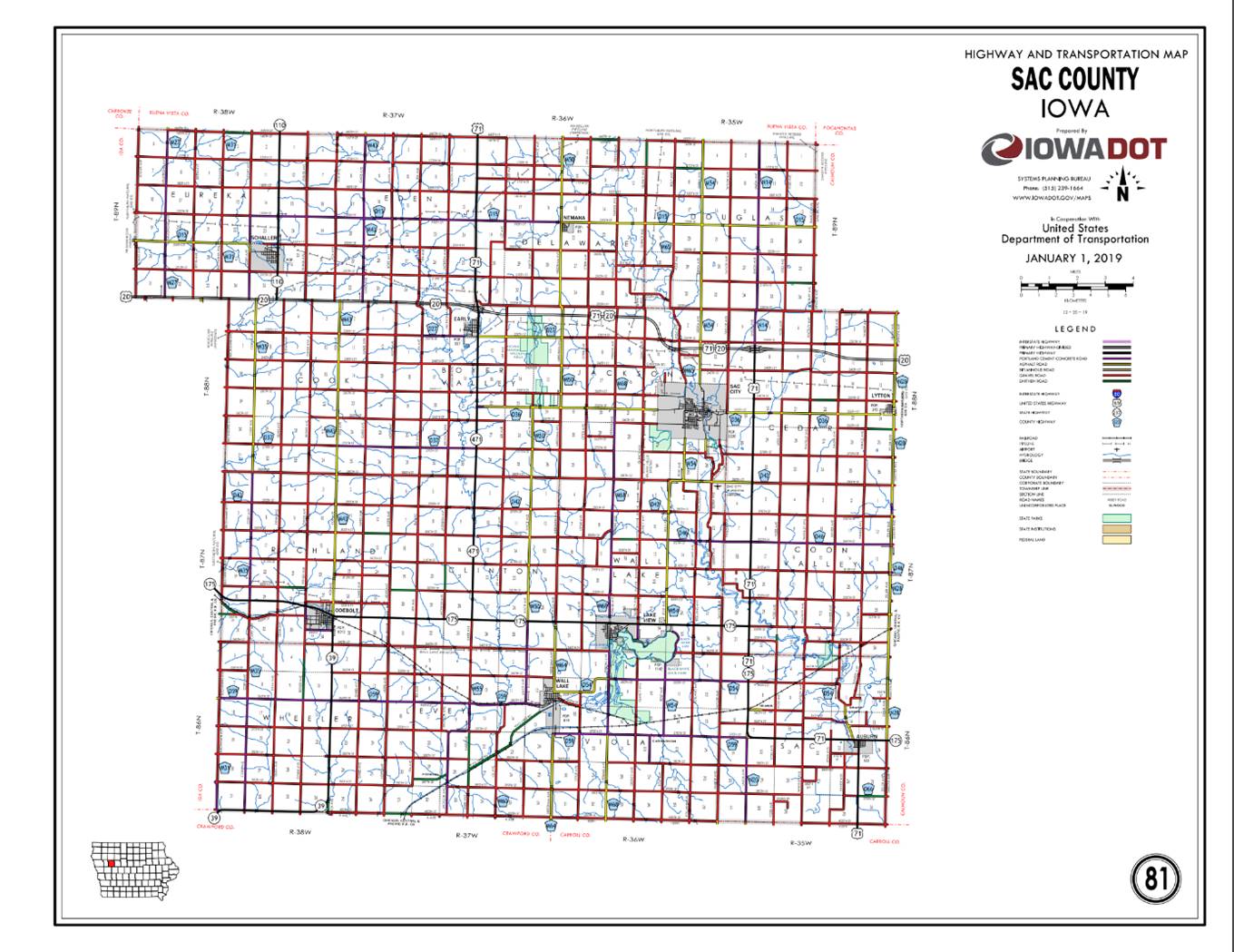
COUNTY: Sac
ROUTE: Iowa 175
ENTERED DATE: 12-9-22
ENTERED BY: Paul Mauer
EFFECTIVE DATE: 4-12-2022
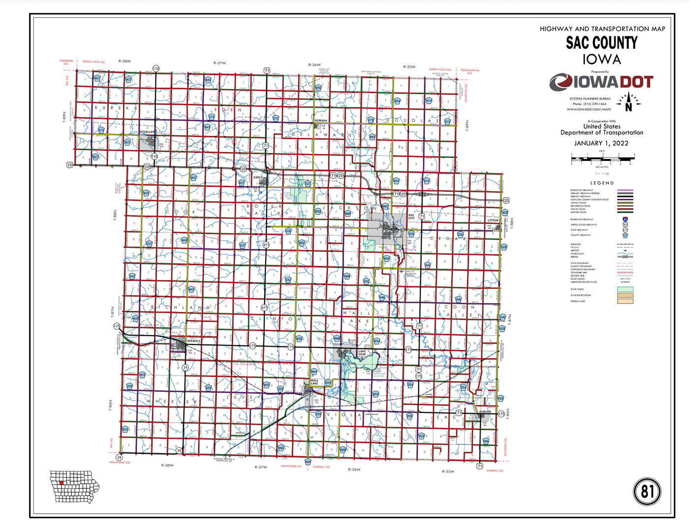
New Description - Iowa 175 and its extensions
in Sac County described as follows:
Beginning on the Sac‑Ida County line at a point
approximately 800 feet north of the W ¼ Corner Section 30‑T87N‑R38W,
Sac County (E ¼ Corner Section 25‑T89N‑R39W, Ida
County); thence curving southeasterly through Section 30‑T87N‑R38W
to a point approximately 300 feet west of the center of Section 30‑T87N‑R38W;
thence easterly following substantially the center section line of Sections 30,
29 and 28‑T87N‑R38W to a point approximately 200 feet east of the W
¼ Corner Section 28‑T87N‑R38W; thence southeasterly through said
Section 28 to the west corporation line of Odebolt, connecting with Market
Street.
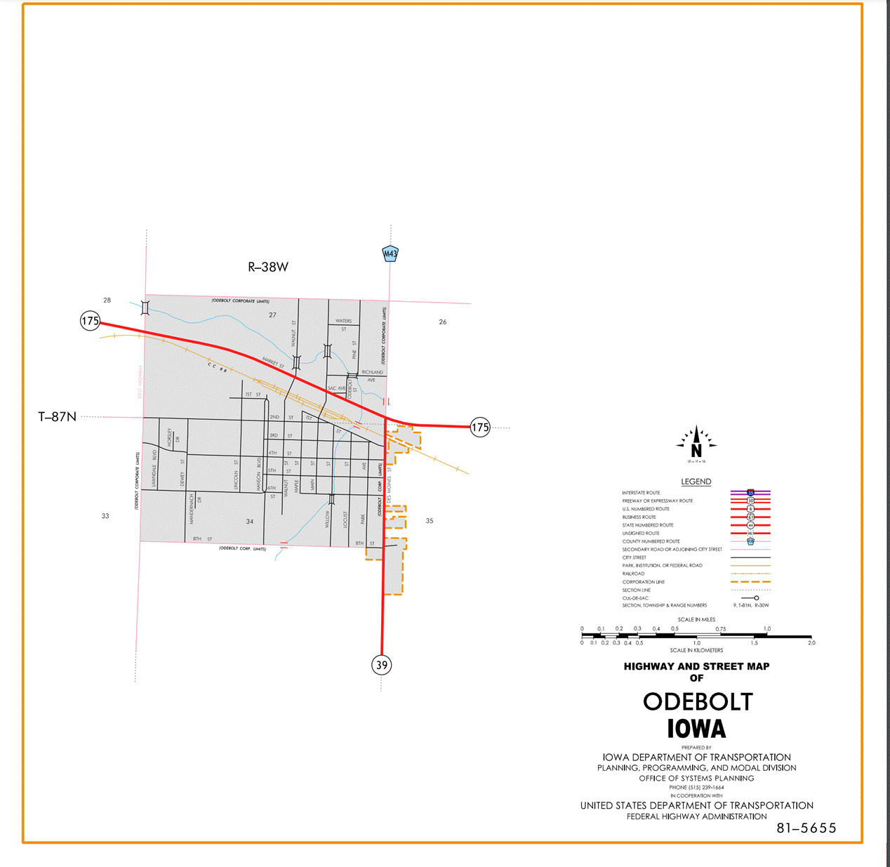
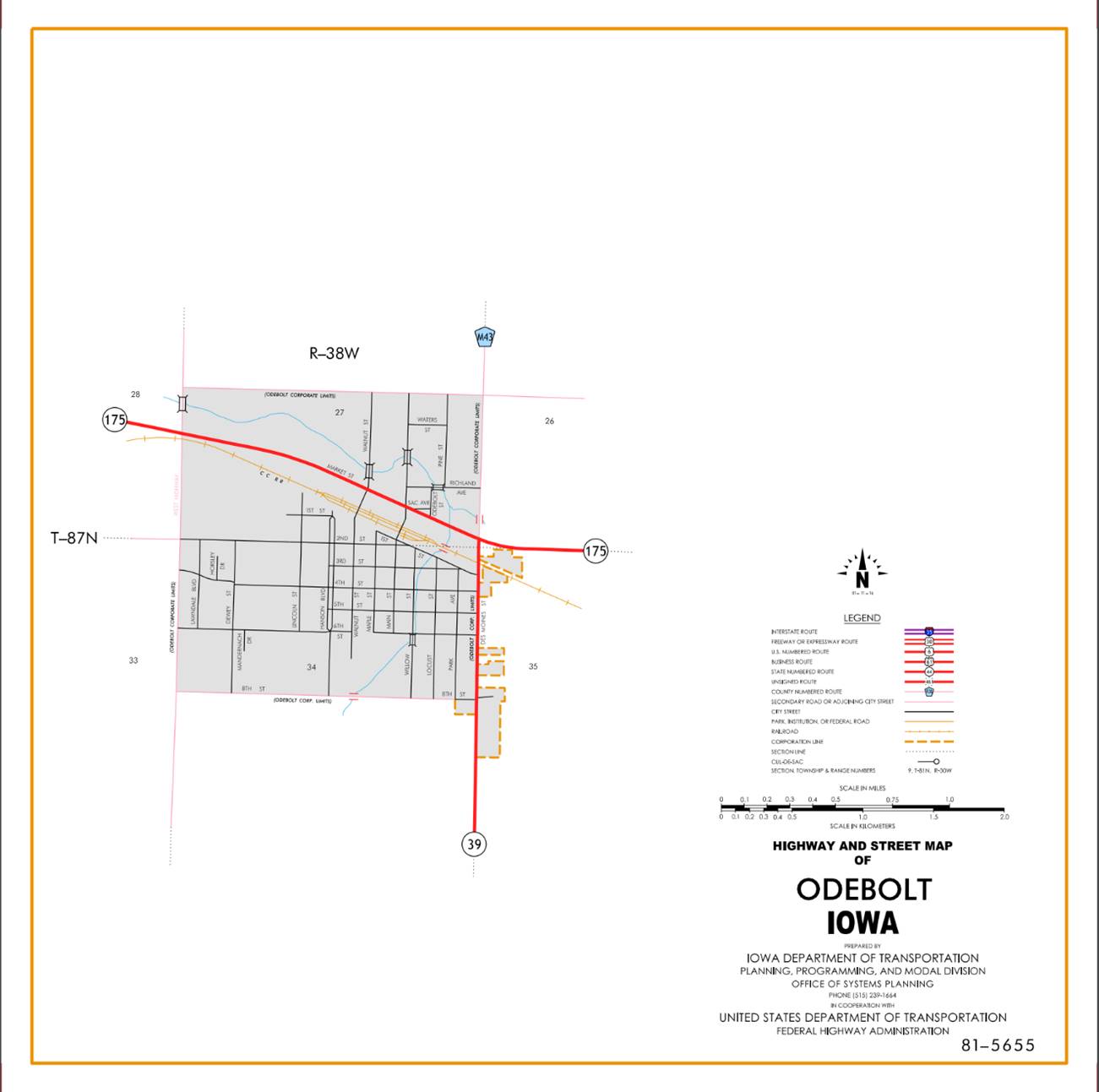
Odebolt:
Beginning on Market Street at the west corporation line;
thence southeasterly on Market Street to the east corporation line.
Beginning again on the east corporation line of Odebolt connecting
with Market Street; thence curving southeasterly through the SW ¼ of
Section 26‑T87N‑R38W (junction Iowa 39) to a point approximately
800 feet east of the NW Corner Section 35-T87N-R38W; thence east following
substantially the section line of Sections 35 and 36-T87N-R38W, Sections 31,
32, 33 (west junction US 71), 34, 35 and 36‑T87N‑R37W and Sections
31 and 32‑T87N‑R36W to the west corporation line of Lake View,
connecting with an unnamed street.
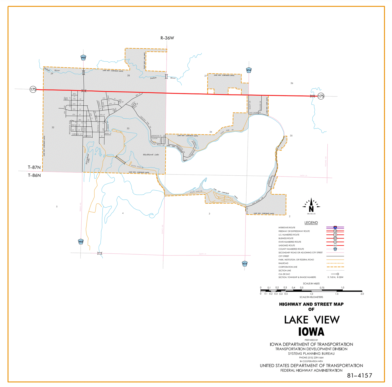
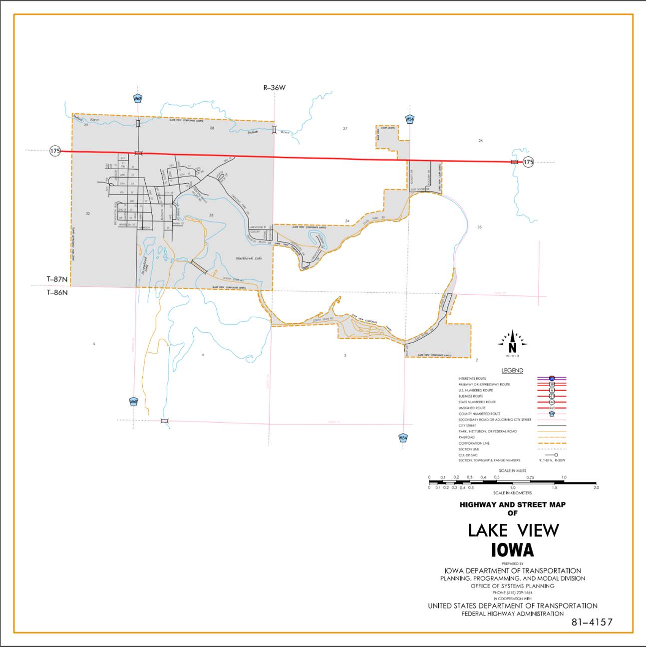
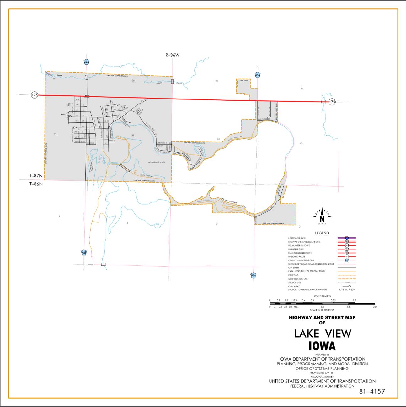
Lake View:
Beginning on an unnamed street at the west corporation line;
thence east on said unnamed street to the east corporation line.
Beginning again on the east corporation line of Lake View
connecting with an unnamed street; thence east following substantially the
section line of Section 34‑T87N‑R36W to the west corporation line
of Lake View, connecting with an unnamed street.
Lake View:
Beginning on an unnamed street at the west corporation line;
thence east on said unnamed street to the east corporation line.
Beginning again on the east corporation line of Lake View
connecting with an unnamed street; thence east following substantially the
section line of Sections 35 and 36‑T87N‑R36W and Section 31‑T87N‑R35W
to a point approximately 1,200 feet west of the NE Corner Section 31‑T87N‑R35W;
thence curving southeasterly through Section 31-T87N-R35W to a point
approximately 1,150 feet south of the NE Corner said Section 31; thence south
following substantially the section line of Section 32‑T87N‑R35W
and Sections 5, 8 and 17‑T86N‑R35W to a point approximately 1,200
feet north of the SW Corner Section 17‑T86N‑R35W; thence curving
southeasterly through Section 17‑T86N‑R35W to a point approximately
1,200 feet east of the NW Corner Section 20‑T86N‑R35W; thence
easterly following substantially the section line of Sections 20, 21, 22, 23
(east junction US 71) and 24‑T86N‑R35W to the Sac‑Calhoun
County line at a point near the SE Corner Section 13‑T86N‑R35W, Sac
County (SW Corner Section 18‑T86N‑R34W, Calhoun County).
OFFICIAL
DESCRIPTION CHANGE
OFFICE:
Research and Analytics
EFFECTIVE
DATE: 12-7-2020
COUNTY:
Sac
ROUTE:
Iowa 175
ENTERED
BY: Paul Mauer
ENTERED
DATE: 2-3-2022
New
Description -
Beginning
on the Sac‑Ida County line at a point approximately 800 feet north of the
W ¼ Corner Section 30‑T87N‑R38W, Sac County (E ¼ Corner Section 25‑T89N‑R39W, Ida
County); thence curving southeasterly through Section 30‑T87N‑R38W
to a point approximately 300 feet west of the center of Section 30‑T87N‑R38W;
thence easterly following substantially the center section line of Sections 30,
29 and 28‑T87N‑R38W to a point approximately 200 feet east of the W
¼ Corner Section 28‑T87N‑R38W; thence southeasterly through said
Section 28 to the west corporation line of Odebolt, connecting with Market
Street.

Odebolt:
Beginning
on
Beginning
again on the east corporation line of Odebolt connecting with Market Street;
thence curving southeasterly through the SW ¼ of Section 26‑T87N‑R38W
(junction Iowa 39) to a point approximately 800 feet east of the NW Corner
Section 35-T87N-R38W; thence east following substantially the section line of
Sections 35 and 36-T87N-R38W, Sections 31, 32, 33 (junction Iowa 471), 34, 35
and 36‑T87N‑R37W and Sections 31 and 32‑T87N‑R36W to
the west corporation line of Lake View, connecting with 330th Street.
Beginning
on 330TH Street at the west corporation line; thence east on 330th
Street to the east corporation line.
Beginning
again on the east corporation line of Lake View connecting with 330th
Street; thence east following substantially the section line of Sections 34‑T87N‑R36W
to the west corporation line of Lake View connecting with 330th
Street.
Lake
View:
Beginning
at the west corporation line of Lake View connecting with 330th
Street; then east on 330th Street to the east corporation line.
Beginning
again at the east corporation line of Lake View connecting with 330th
Street; thence east through Sections 35 and 36‑T87N‑R36W and
Section 31‑T87N‑R35W to the NE Corner Section 31‑T87N‑R35W
(west junction US 71); thence south following substantially the section line of
Section 31 and 32-T87N-R35W, and Sections 5, 8 and 17‑T86N‑R35W to
a point approximately 1,200 feet north of the SW Corner Section 17‑T86N‑R35W;
thence curving southeasterly through Section 17‑T86N‑R35W to a
point approximately 1,200 feet east of the NW Corner Section 20‑T86N‑R35W;
thence easterly following substantially the section line of Sections 20, 21,
22, 23 (east junction US 71) and 24‑T86N‑R35W to the Sac‑Calhoun
County line at a point near the SE Corner Section 13‑T86N‑R35W, Sac
County (SW Corner Section 18‑T86N‑R34W, Calhoun County).
OFFICIAL
DESCRIPTION CHANGE
OFFICE:
Research and Analytics
EFFECTIVE
DATE: 6-14-2016
COUNTY:
Sac
ROUTE:
Iowa 175
ENTERED
BY: Paul Mauer
ENTERED
DATE: 1-31-2020
New
Description -
Beginning
on the Sac‑Ida County line at a point approximately 800 feet north of the
W ¼ Corner Section 30‑T87N‑R38W, Sac County (E ¼ Corner Section 25‑T89N‑R39W, Ida
County); thence curving southeasterly through Section 30‑T87N‑R38W
to a point approximately 300 feet west of the center of Section 30‑T87N‑R38W;
thence easterly following substantially the center section line of Sections 30,
29 and 28‑T87N‑R38W to a point approximately 200 feet east of the W
¼ Corner Section 28‑T87N‑R38W; thence southeasterly through said
Section 28 to the west corporation line of Odebolt, connecting with Market
Street.
Odebolt:
Beginning
on
Beginning
again on the east corporation line of Odebolt connecting with Market Street;
thence curving southeasterly through the SW ¼ of Section 26‑T87N‑R38W
(junction Iowa 39) to a point approximately 800 feet east of the NW Corner
Section 35-T87N-R38W; thence east following substantially the section line of
Sections 35 and 36-T87N-R38W, Sections 31, 32, 33 (junction Iowa 471), 34, 35
and 36‑T87N‑R37W and Sections 31 and 32‑T87N‑R36W to
the west corporation line of Lake View, connecting with 330th
Street.
Beginning
on 330TH Street at the west corporation line; thence east on 330th
Street to the east corporation line.
Beginning
again on the east corporation line of Lake View connecting with 330th
Street; thence east following substantially the section line of Sections 34‑T87N‑R36W
to the west corporation line of Lake View connecting with 330th
Street.
Lake
View:
Beginning
at the west corporation line of Lake View connecting with 330th
Street; then east on 330th Street to the east corporation line.
Beginning
again at the east corporation line of Lake View connecting with 330th
Street; thence east through Sections 35 and 36‑T87N‑R36W
and Section 31‑T87N‑R35W to the NE Corner Section 31‑T87N‑R35W
(west junction US 71); thence south following substantially the section line of
Section 31 and 32-T87N-R35W, and Sections 5, 8 and 17‑T86N‑R35W to
a point approximately 1,200 feet north of the SW Corner Section 17‑T86N‑R35W;
thence curving southeasterly through Section 17‑T86N‑R35W to a
point approximately 1,200 feet east of the NW Corner Section 20‑T86N‑R35W;
thence easterly following substantially the section line of Sections 20, 21,
22, 23 (east junction US 71) and 24‑T86N‑R35W to the Sac‑Calhoun
County line at a point near the SE Corner Section 13‑T86N‑R35W, Sac
County (SW Corner Section 18‑T86N‑R34W, Calhoun County).
OFFICIAL
DESCRIPTION CHANGE
COUNTY: Sac
ROUTE:
STAFF
ACTION NUMBER: S-87-1514
APPROVAL
DATE: 5-13-87
New
Description -
Beginning
on the Sac‑Ida County line at a point approximately 800 feet north of the
W ¼ Corner Section 30‑T87N‑R38W, Sac County (E ¼ Corner Section 25‑T89N‑R39W, Ida
County); thence curving southeasterly through Section 30‑T87N‑R38W
to a point approximately 300 feet west of the center of Section 30‑T87N‑R38W;
thence easterly following substantially the center section line of Sections 30,
29 and 28‑T87N‑R38W to a point approximately 200 feet east of the W
¼ Corner Section 28‑T87N‑R38W; thence southeasterly through said
Section 28 to the west corporation line of Odebolt, connecting with Market
Street.
Odebolt:
Beginning
on
Beginning
again on the east corporation line of Odebolt connecting with
Beginning
on an unnamed street at the west corporation line; thence east on said unnamed
street to the east corporation line.
Beginning
again on the east corporation line of Lake View connecting with an unnamed
street; thence east following substantially the section line of Sections 34, 35
and 36‑T87N‑R36W and Section 31‑T87N‑R35W to a point
approximately 1,200 feet west of the NE Corner Section 31‑T87N‑R35W;
thence curving southeasterly through Section 31-T87N-R35W to a point
approximately 1,150 feet south of the NE Corner said Section 31; thence south
following substantially the section line of Section 32‑T87N‑R35W
and Sections 5, 8 and 17‑T86N‑R35W to a point approximately 1,200
feet north of the SW Corner Section 17‑T86N‑R35W; thence curving
southeasterly through Section 17‑T86N‑R35W to a point approximately
1,200 feet east of the NW Corner Section 20‑T86N‑R35W; thence
easterly following substantially the section line of Sections 20, 21, 22, 23
(east junction US 71) and 24‑T86N‑R35W to the Sac‑Calhoun
County line at a point near the SE Corner Section 13‑T86N‑R35W, Sac
County (SW Corner Section 18‑T86N‑R34W, Calhoun County).
COMMISSION
ORDER
DIVISION: Planning & Research
COMMISSION
ORDER NUMBER:
PR-79-272
SUBMITTED
BY: C.I. MacGillivray
MEETING
DATE:
11-2-78
TITLE:
DISCUSSION/BACKGROUND:
Due
to a review of our Primary Road System Records Iowa 175 in
PROPOSAL/ACTION
RECOMMENDATION:
it
is recommended that the old description of
Locate
Beginning
on the Sac‑Ida County line at a point approximately 800 feet north of the
W ¼ Corner Section 30‑T87N‑R38W, Sac County (E ¼ Corner Section 25‑T89N‑R39W, Ida
County); thence curving southeasterly through Section 30‑T87N‑R38W
to a point approximately 300 feet west of the center of Section 30‑T87N‑R38W;
thence easterly following substantially the center section line of Sections 30,
29, and 28-T87N-R38W to a point approximately 200 feet east of the W ¼ Corner
Section 28‑T87N‑R38W; thence southeasterly through said Section 28
to the west corporation line of the City of Odebolt connecting with an unnamed
street.
Odebolt:
Beginning
on the west corporation line connecting with an unnamed street; thence in a
southeasterly direction to the east corporation line connecting with an unnamed
street.
Beginning
on the east corporation line of the City of Odebolt connecting with an unnamed
street; thence curving southeasterly through the SW ¼ of Section 26-T87N-R38W
(junction Iowa 39) to a point approximately 800 feet east of the NW Corner
Section 35‑T87N‑R38W; thence east following substantially the
section line of Sections 35 and 36‑T87N‑R38W, Sections 31, 32, 33
(west junction US 71), 34, 35, and 36‑T87N‑R37W and Sections 31 and
32‑T87N‑R36W to the west corporation line of the City of Lake View
connecting with an unnamed street.
Beginning
on the west corporation line connecting with an unnamed street; thence easterly
to the east corporation line connecting with an unnamed street.
Beginning
again on the east corporation line of the City of Lake View connecting with an
unnamed street; thence easterly following substantially the section line of
Sections 34, 35, and 36‑T87N‑R36W and Section 31‑T87N‑R35W
to a point approximately 1200 feet west of the NE Corner Section 31‑T87N‑R35W;
thence curving southeasterly through Section 31‑T87N‑R35W to a
point approximately 1150 feet south of the NE Corner said Section 31; thence
southerly following substantially the section line of Section 32‑T87N‑R35W
and Sections 5, 8, and 17‑T86N‑R35W to a point approximately 1200
feet north of the SW Corner Section 17‑T86N‑R35W; thence curving
southeasterly through Section 17-T86N-R35W to a point approximately 1200 feet
east of the NW Corner Section 20‑T86N‑R35W; thence easterly
following substantially the section line of Sections 20, 21, 22, 23 (east
junction US 71) and 24‑T86N‑R35W to the Sac‑Calhoun County
line at a point near the SE Corner Section 13‑T86N‑R35W, Sac County
(SW Corner Section 18‑T86N‑R34W, Calhoun County).
REVISED: 5-13-87
OFFICIAL
DESCRIPTION CHANGE
COUNTY: Sac
ROUTE:
APPROVAL
DATE: 10-28-47
Beginning
on the Sac-Ida County line at a point approximately 800 feet north of the W ¼
Corner Section 30-T87N-R38W, Sac County (E ¼
Corner Section 25-T89N-R39W, Ida County); thence curving southeasterly
to a point approximately 300 feet west of the center of Section 30-T87N-R38W;
thence east following substantially the ¼ Section line to a point approximately
200 feet east of the W ¼ Corner Section 28-T87N-R38W; thence southeasterly
through said Section 28 to the west corporation line of the town of Odebolt
connecting with Market Street.
Beginning
again on the east corporation line of the town of Odebolt connecting with
Market Street; thence curving southeasterly to a point approximately 800 feet
east of the NW Corner Section 35-T87N-R38W; thence east following substantially
the section line to the west corporation line of the town of Lake View
connecting with Ninth Street.
Beginning
again at the east corporation line of the town of Lake View connecting with
Ninth Street; thence east following substantially the section line to a point
approximately 1100 feet west of the NE Corner Section 31-T87N-R35W; thence
curving southeasterly to a point approximately 1100 feet south of the NE Corner
of said Section 31; thence south following substantially the section line to a
point approximately 1200 feet north of the SW Corner Section 17-T86N-R35W;
thence curving southeasterly to a point approximately 1200 feet east of the SW
Corner said Section 17; thence east following substantially the section line to
the Sac-Calhoun County line near the SE
Corner Section 13-T86N-R35W, Sac County (SW Corner Section 18-T86N-R34W, Calhoun
County).
OFFICIAL
DESCRIPTION CHANGE
COUNTY: Sac
CITY
OF: Odebolt
ROUTE:
APPROVAL
DATE: 3-19-40
Commencing
on Market Street at the west corporation line; thence southeasterly on Market
Street to the east corporation line.
NOTE: Revised from
REVISED: 10-28-47
OFFICIAL
DESCRIPTION CHANGE
COUNTY: Sac
CITY
OF:
ROUTE: US 71 and
APPROVAL
DATE: 2-5-36 (#175 - 10-28-47)
Commencing
on Ninth Street at the west corporation line; thence easterly on Ninth Street
to the east corporation line.