OFFICIAL
DESCRIPTION CHANGE
OFFICE:
Transportation Data
EFFECTIVE DATE: 07-01-2003
ENTERED
BY: Stefani Wonders
ENTERED
DATE: 08-22-2006
DISCUSSION/BACKGROUND:
Senate File 451 transferred
OFFICIAL
DESCRIPTION CHANGE
COUNTY: Pottawattamie
ROUTE:
STAFF
ACTION NUMBER: S-87-1517
APPROVAL
DATE: 5-13-87
New
Description ‑
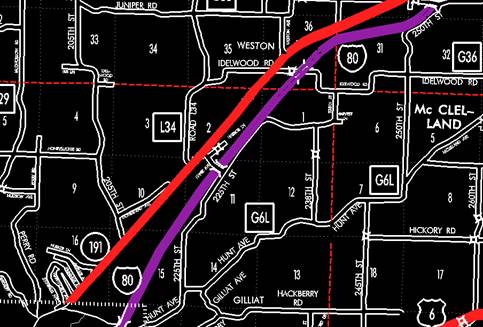
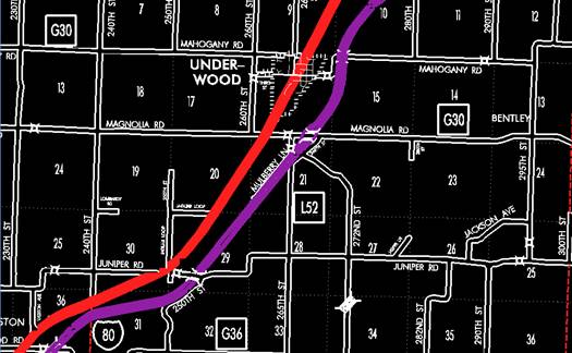
Beginning on the north corporation line
of
Underwood:
Beginning on an unnamed street at the
south corporation line; thence in a northeasterly direction on an unnamed
street to the north corporation line.
Beginning again on the north
corporation line of Underwood connecting with an unnamed street; thence in a
northeasterly direction through Sections 9, 10 and 3‑T76N‑R42W, and
Sections 34, 35, 26 and 25‑T77N‑R42W to the west corporation line
of Neola connecting with
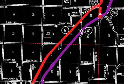
Neola:
Beginning on
Beginning
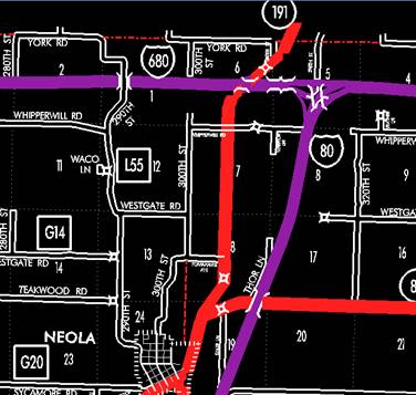
again on the north corporation line of Neola connecting with Front Street;
thence in a northeasterly direction through Sections 19 (junction Iowa 83) and
18‑T77N‑R41W to a point approximately ¼ mile north of the S ¼
Corner Section 18‑T77N‑R41W; thence northerly following
substantially the quarter section line of Sections 18, 7 and 6‑T77N‑R41W
to a point approximately ¼ mile north of the S ¼ Corner Section 6‑T77N‑R41W;
thence curving in a northeasterly direction through Sections 6 (interchange
with Interstate 680) and 5‑T77N‑R41W to the Pottawattamie‑Harrison
County line at a point approximately 800 feet east of the NW Corner Section 5‑T77N‑R41W,
Pottawattamie County (SW Corner Section 32‑T78N‑R4lW, Harrison
County).
COMMISSION
ORDER
DIVISION:
Planning & Research
COMMISSION
ORDER NUMBER:
PR-82-634
SUBMITTED
BY: Patrick R. Cain
MEETING
DATE: 4-13-82
DISCUSSION/BACKGROUND:
Iowa
191 begins at US 6 in the City of Council Bluffs, and travels generally
northeasterly via the Cities of Underwood and Neola to the Pottawattamie‑Harrison
County line approximately four miles northeast of the City of Neola.
Transfer
of jurisdiction agreement number TJ‑191‑0(11) between the City of
Council Bluffs and the Iowa Department of Transportation transferred that
portion of Iowa 191 from Broadway Street (junction US 6) northeasterly to the
north corporation line to city jurisdiction on October 20, 1981.
PROPOSAL
/ ACTION RECOMMENDATION:
It
is recommended the commission approve depleting the present description of
Locate
Beginning
on the north corporation line of the City of
Underwood:
Beginning on the south corporation
line connecting with an unnamed street thence in a northeasterly direction to
the north corporation line connecting with an unnamed street.
Beginning again on the north
corporation line of the City of
Neola:
Beginning on the west corporation
line connecting with an unnamed street; thence in a northeasterly direction to
the north corporation line connecting with an unnamed street.
Beginning
again on the north corporation line of the City of Neola connecting with an
unnamed street; thence in a northeasterly direction through Sections 19
(junction Iowa 83) and 18‑T77N‑R41W to a point approximately ¼
mile north of the S ¼ Corner Section 18‑T77N-R41W; thence northerly
following substantially the quarter section line of Sections 18, 7 and 6‑T77N‑R41W
to a point approximately ¼ mile north of the S ¼ Corner Section 6‑T77N‑R41W;
thence curving in a northeasterly direction through Sections 6 (interchange
with Interstate 680) and 5‑T77N‑R41W to the Pottawattamie-Harrison
County line at a point approximately 800 feet east of the NW Corner Section 5‑T77N‑R41W,
Pottawattamie County (SW Corner Section 32‑T78N‑R41W, Harrison
County).
REVISED: 5-13-87
COMMISSION
ORDER
DIVISION:
Planning & Research
COMMISSION
ORDER NUMBER:
PR-79-272
SUBMITTED
BY: C.I. MacGillivray
MEETING
DATE: 11-2-78
DISCUSSION/BACKGROUND:
Due
to a review of our Primary Road System records
PROPOSAL/ACTION
RECOMMENDATION:
Locate
Beginning
on an unnamed street at Broadway (junction
Beginning
on the north corporation line of the City of Council Bluffs connecting with an
unnamed street; thence in a northeasterly direction along the west side of the
Chicago, Rock Island and Pacific Railway and substantially parallel thereto
through Sections 16, 15, 10, 11 and 2‑T75N‑R43W, Sections 35 and 36‑T76N‑R43W
and Sections 31, 30, 29, 20, 21 and 16‑T76N‑R42W to the south
corporation line of the City of
Underwood:
Beginning on the south corporation
line connecting with an unnamed street; thence in a northeasterly direction to the
north corporation line connecting with an unnamed street.
Beginning
again on the north corporation line of the city of
Neola:
Beginning on the west corporation
line connecting with an unnamed street; thence in a northeasterly direction to
the north corporation line connecting with an unnamed street.
Beginning
again on the north corporation line of the City of Neola connecting with an
unnamed street; thence in a northeasterly direction through Sections 19
(junction Iowa 83) and 18‑T77N‑R41W to a point approximately ¼ mile
north of the S ¼ Corner Section 18‑T77N‑R41W thence northerly
following substantially the quarter section line of Sections 18,17 and 6‑T77N‑R41W
to a point approximately ¼ mile north of the St Corner Section 6‑T77N‑R41W;
thence curving in a northeasterly direction through Sections 6 (interchange
with Interstate 680) and 5‑T77N‑R41W to the Pottawattamie‑Harrison
County line at a point approximately 800 feet east of the NW Corner Section 5‑T77N‑R41W,
Pottawattamie County (SW Corner Section 32‑T78N‑R41W, Harrison
County).
NOW,
THEREFORE: Be it resolved that the Iowa Department of Transportation approve
the location of
NOTE:
To become effective upon the adoption of this resolution.
REVISED: 4-13-82
COMMISSION
RESOLUTION
DIVISION:
Planning & Research
COMMISSION
ORDER NUMBER:
69-1440
SUBMITTED
BY: Raymond L. Kassel
MEETING
DATE: 10-15-69
Beginning
at a point on the north corporation line of the City of Council Bluffs,
connecting with an unnamed street; thence in a northeasterly direction along
the west side of the Chicago, Rock Island and Pacific Railway and substantially
parallel thereto through Sections 16, 15, 10, 11 and 2‑T75N‑R43W,
Section 36-T76N‑R43W, and Sections 31, 30, 29, 20, 21 and 16‑T76N‑R42W
to the south corporation line of the Town of
Beginning
again on the north corporation line of the Town of Underwood, connecting with an
unnamed street on the west side of the Chicago, Rock Island and Pacific
Railway; thence in a northeasterly direction along the west side of said
railway and substantially parallel thereto through Sections 9, 10 and 3‑T76N‑R42W,
and Sections 34, 35, 26 and 25‑T77N‑R42W to the west corporation
line of the Town of
Beginning
again on the north corporation line of the Town of
OFFICIAL
DESCRIPTION CHANGE
COUNTY: Pottawattamie
CITY
OF:
ROUTE:
APPROVAL
DATE: 10-15-69
Beginning
at a point approximately 1100 feet west of the east section line in the SE ¼ of
Section 20‑T75N‑R43W at the intersection of an unnamed street and
relocated US 6; thence in a northeasterly direction on said unnamed street to
the north corporation line.
OFFICIAL
DESCRIPTION CHANGE
COUNTY: Pottawattamie
ROUTE:
APPROVAL
DATE: 12-31-68
Beginning
at a point approximately 1100 feet west of the east section line in the SW ¼
Section 20‑T75N-R43W; thence in a northeasterly direction through Section
20 and 21‑T75N‑R43W, to a point on the west side of the
Underwood:
Beginning
on an unnamed street at the south corporation line; thence northeasterly on
unnamed street to the north corporation line.
Beginning
again on the north corporation line of the Town of Underwood, connecting with
an unnamed street on the west side of the Chicago, Rock Island and Pacific Railway;
thence in a northeasterly direction along the west side of said railway and
substantially parallel thereto through Section 9, 10 and Section 3-T76N-R42W,
and Sec 34, 35, 26 and 25‑T77N‑R42W to the west corporation line of
the Town of Neola, connecting with an unnamed street.
Neola:
Beginning
on unnamed street at the west corporation line near the southwest corner of the
corporation; thence northeasterly on unnamed street approximately 1081 feet to
Beginning
again on the north corporation line of the Town of