OFFICIAL
DESCRIPTION CHANGE
OFFICE:
Analytics
EFFECTIVE
DATE: 06-27-2018
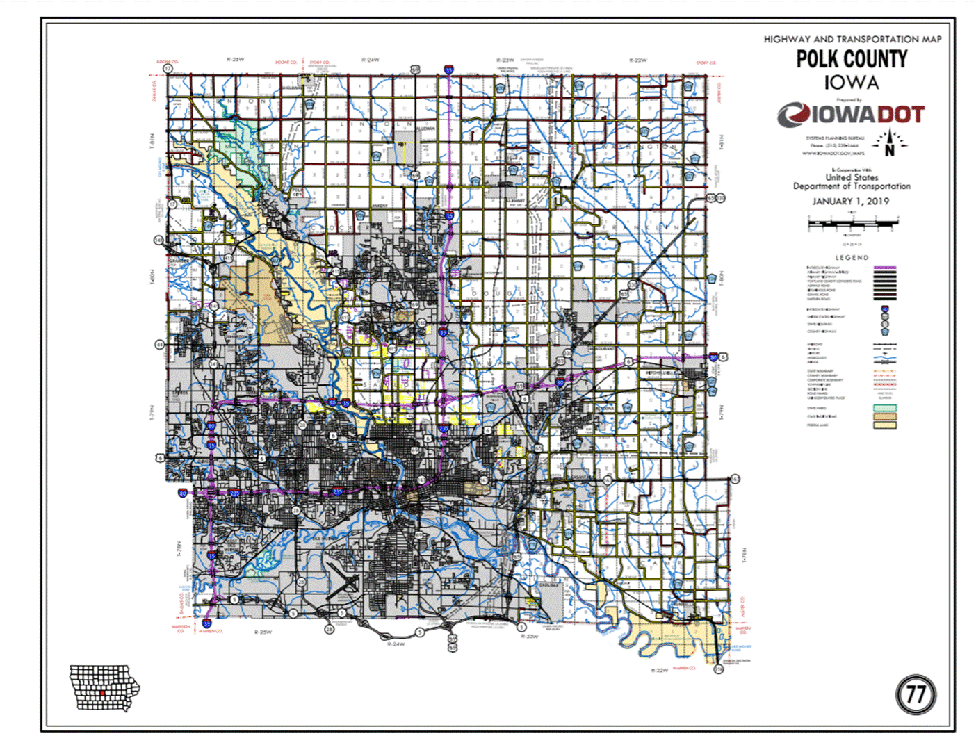
COUNTY:
Polk
ROUTE:
US 65
ENTERED
BY: Paul
Mauer
ENTERED
DATE: 08-14-2020
New
Description - US 65 and its extensions in Polk County
described as follows:
Des Moines:
Beginning
at the Polk-Warren County line (south corporation line of Des Moines)
approximately 840 feet west of the S ¼ Corner of Section 31-T78N-R23W, Polk
County (N ¼ Corner of Section 6-T77N-R23W, Warren County) connecting with Iowa
5; thence in a northeasterly direction on Iowa 5 through Section 31-T78N-R23W
to the east corporation line of Des Moines (approximately 1100 feet east and
290 feet north of the S ¼ Corner of Section 31-T78N-R23W).
Beginning
again on the west corporation line of Des Moines (approximately 1100 feet east
and 290 feet north of the S ¼ Corner of Section 31-T78N-R23W) connecting with
Iowa 5; thence in an easterly and northeasterly direction on Iowa 5 through
Section 32-T78N-R23W to the junction of Iowa 5 (approximately 1300 feet west
and 520 feet north of the SE Corner of
Section 32-T78N-R23W); thence in a northeasterly, northerly, and northeasterly
direction through Sections 32, 33, 28, and 21-T78N-R23W to a point near the N ¼
Corner of Section 21-T78N-R23W; thence northwesterly through Section
16-T78N-R23W to the south corporation line of Pleasant Hill (a point near the E
¼ Corner NW ¼ of Section 16-T78N-R23W).
Pleasant Hill:
Beginning
on the south corporation line (a point near the E ¼ Corner NW ¼ of Section
16-T78N-R23W); thence northerly, northeasterly, and northerly to the north
corporation line (approximately 610 feet west of the Center of Section
35-T79N-R23W).
Beginning
again on the north corporation line of Pleasant Hill (approximately 610 feet
west of the Center of Section 35-T79N-R23W); thence in a northerly and
northwesterly direction through Sections 35, 26, 22, and 15-T79N-R23W to the
junction of Interstate 80; thence easterly on Interstate 80 to the west
corporation line of Altoona (approximately 600 feet north and 370 feet east of
the SW Corner of Section 10-T79N-R23W).
Altoona:
Beginning
on the west corporation line (approximately 600 feet north and 370 feet east of
the SW Corner of Section 10-T79N-R23W), connecting with Interstate 80; thence
east on Interstate 80 to the junction of US 6/Hubbell Avenue; thence
northwesterly on Hubbell Avenue to the east corporation line/west corporation
line of Bondurant (approximately 730 feet south of the NW Corner of Section
12-T79N-R23W).
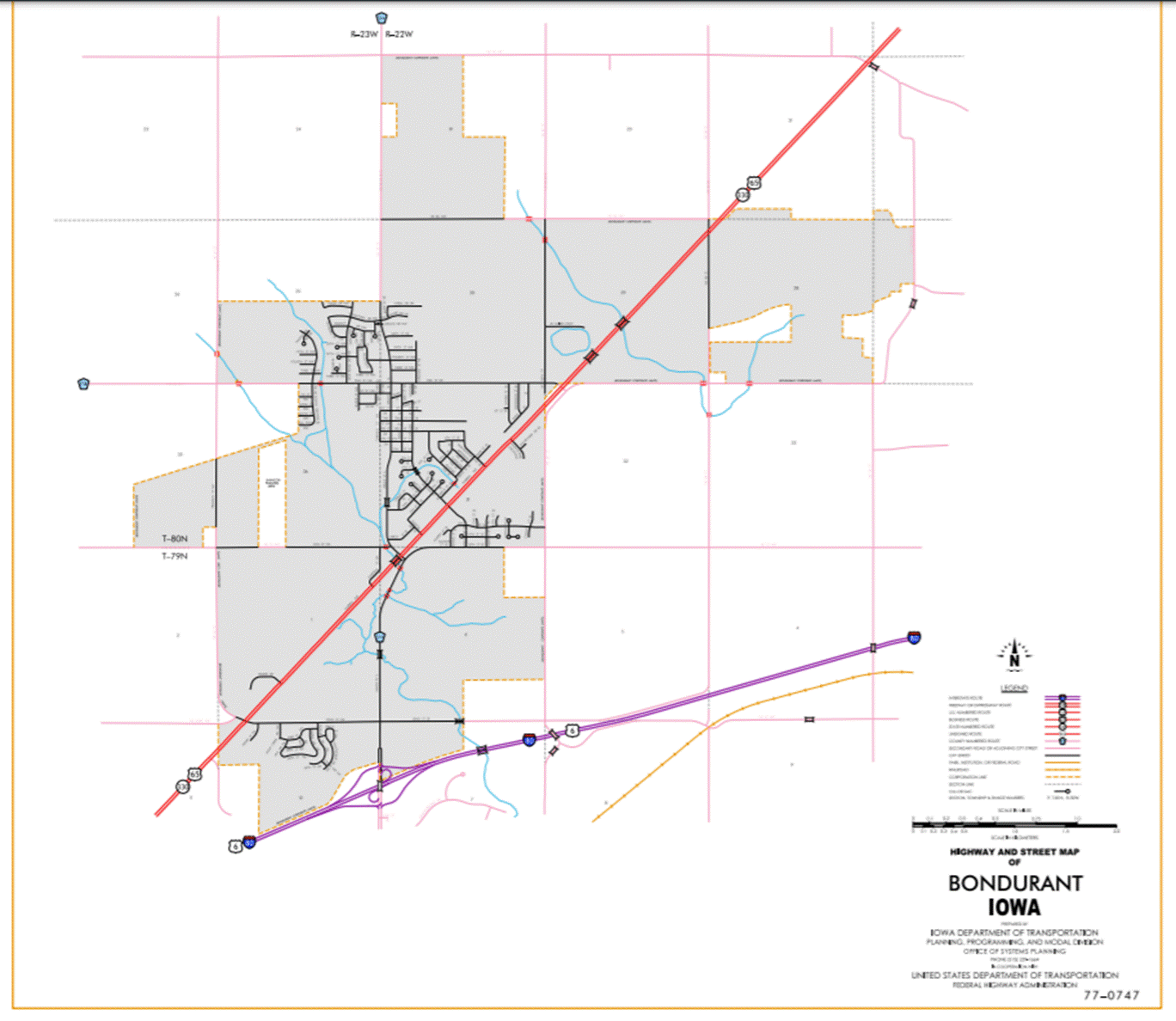
Bondurant:
Beginning
on the west corporation line (approximately 730 feet south of the NW Corner of
Section 12-T79N-R23W), connecting with Hubbell Avenue; thence northeasterly on
Hubbell Avenue to the east corporation line.
Beginning
again on the east corporation line of Bondurant connecting with Hubbell Avenue;
thence northeasterly through Sections 21, 16, 15, 10, 11, 2, and 1-T80N-R22W to
a point approximately 2290 feet north and 1080 feet east of the SW Corner of
Section 1-T80N-R22W; thence northerly and northeasterly to the Polk-Jasper
County Line at a point near the E ¼ Corner of Section 36-T81N-R22W, Polk County
(W ¼ Corner of Section 31-T81N-R21W, Jasper County).
STAFF ACTION
OFFICE:
Transportation
Data
STAFF
ACTION NUMBER: S-03-0771
SUBMITTED
BY: Peggi
Knight
SUBMITTAL
DATE: 04-14-2003
TITLE:
Official
Description Change: US 65 in
Polk County
DISCUSSION
/ BACKGROUND:
New
Description - US 65 and its extensions in Polk County
described as follows:
Des Moines:
Beginning
at the Polk-Warren County line (south corporation line of Des Moines)
approximately 840 feet west of the S ¼ Corner of Section 31-T78N-R23W, Polk
County (N ¼ Corner of Section 6-T77N-R23W, Warren County) connecting with Iowa
5; thence in a northeasterly direction on Iowa 5 through Section 31-T78N-R23W
to the east corporation line of Des Moines (approximately 1100 feet east and
290 feet north of the S ¼ Corner of Section 31-T78N-R23W).
Beginning
again on the west corporation line of Des Moines (approximately 1100 feet east
and 290 feet north of the S ¼ Corner of Section 31-T78N-R23W) connecting with
Iowa 5; thence in an easterly and northeasterly direction on Iowa 5 through Section
32-T78N-R23W to the junction of Iowa 5 (approximately 1300 feet west and 520
feet north of the SE Corner of Section
32-T78N-R23W); thence in a northeasterly, northerly, and northeasterly
direction through Sections 32, 33, 28, and 21-T78N-R23W to a point near the N ¼
Corner of Section 21-T78N-R23W; thence northwesterly through Section
16-T78N-R23W to the south corporation line of Pleasant Hill (a point near the E
¼ Corner NW ¼ of Section 16-T78N-R23W).
Pleasant Hill:
Beginning
on the south corporation line (a point near the E ¼ Corner NW ¼ of Section
16-T78N-R23W); thence northerly, northeasterly, and northerly to the north
corporation line (approximately 610 feet west of the Center of Section
35-T79N-R23W).
Beginning
again on the north corporation line of Pleasant Hill (approximately 610 feet
west of the Center of Section 35-T79N-R23W); thence in a northerly and
northwesterly direction through Sections 35, 26, 22, and 15-T79N-R23W to the
junction of Interstate 80; thence easterly on Interstate 80 to the west
corporation line of Altoona (approximately 600 feet north and 370 feet east of
the SW Corner of Section 10-T79N-R23W).
Altoona:
Beginning
on the west corporation line (approximately 600 feet north and 370 feet east of
the SW Corner of Section 10-T79N-R23W), connecting with Interstate 80; thence
east on Interstate 80 to the junction of US 6/Hubbell Avenue; thence
northwesterly on Hubbell Avenue to the east corporation line/west corporation
line of Bondurant (approximately 730 feet south of the NW Corner of Section
12-T79N-R23W).
Bondurant:
Beginning
on the west corporation line (approximately 730 feet south of the NW Corner of
Section 12-T79N-R23W), connecting with Hubbell Avenue; thence northeasterly on Hubbell Avenue to the
east corporation line (a point near the Center SW ¼ of Section 29-T80N-R22W).
Beginning
again on the east corporation line of Bondurant (a point near the Center SW ¼
of Section 29-T80N-R22W), connecting with Hubbell Avenue; thence northeasterly
through Sections 29, 28, 21, 16, 15, 10, 11, 2, and 1-T80N-R22W to a point
approximately 2290 feet north and 1080 feet east of the SW Corner of Section
1-T80N-R22W; thence northerly and northeasterly to the Polk-Jasper County Line
at a point near the E ¼ Corner of Section 36-T81N-R22W, Polk County (W ¼ Corner
of Section 31-T81N-R21W, Jasper County).
PROPOSAL
/ACTION RECOMMENDATION:
It
is recommended that the old description of US 65 and its extension in Polk County
be deleted and the new description be included in the Primary Road System.
STAFF
ACTION
OFFICE: Transportation Data
STAFF
ACTION NUMBER: S-03-0092
SUBMITTED
BY: Peggi
Knight
SUBMITTAL
DATE:
07-30-2002
TITLE: Official Description Change: US
65 in Polk County
DISCUSSION
/ BACKGROUND:
New
Description - US 65 and its extensions in Polk County
described as follows:
Des Moines:
Beginning
at the Polk-Warren County line (south corporation line of Des Moines)
approximately 840 feet west of the S ¼ Corner of Section 31-T78N-R23W, Polk
County (N ¼ Corner of Section 6-T77N-R23W, Warren County) connecting with Iowa
5; thence in a northeasterly direction on Iowa 5 through Section 31-T78N-R23W
to the east corporation line of Des Moines (approximately 1100 feet east and
290 feet north of the S ¼ Corner of Section 31-T78N-R23W).
Beginning
again on the west corporation line of Des Moines (approximately 1100 feet east
and 290 feet north of the S ¼ Corner of Section 31-T78N-R23W) connecting with
Iowa 5; thence in an easterly and northeasterly direction on Iowa 5 through
Section 32-T78N-R23W to the junction of Iowa 5 (approximately 1300 feet west
and 520 feet north of the SE Corner of Section 32-T78N-R23W); thence in a
northeasterly, northerly, and northeasterly direction through Sections 32, 33,
28, and 21-T78N-R23W to a point near the N ¼ Corner of Section 21-T78N-R23W;
thence northwesterly through Section 16-T78N-R23W to the south corporation line
of Pleasant Hill (a point near the E ¼ Corner NW ¼ of Section 16-T78N-R23W).
Pleasant Hill:
Beginning
on the south corporation line (a point near the E ¼ Corner NW ¼ of Section
16-T78N-R23W); thence northerly, northeasterly, and northerly to the north
corporation line (approximately 610 feet west of the Center of Section
35-T79N-R23W).
Beginning
again on the north corporation line of Pleasant Hill (approximately 610 feet
west of the Center of Section 35-T79N-R23W); thence in a northerly and
northwesterly direction through Sections 35, 26, 22, and 15-T79N-R23W to the
junction of Interstate 80; thence easterly on Interstate 80 to the west
corporation line of Altoona (approximately 600 feet north and 370 feet east of
the SW Corner of Section 10-T79N-R23W).
Altoona:
Beginning
on the west corporation line (approximately 600 feet north and 370 feet east of
the SW Corner of Section 10-T79N-R23W), connecting with Interstate 80; thence
east on Interstate 80 to the junction of US 6/Hubbell Avenue; thence
northwesterly on Hubbell Avenue to the east corporation line/west corporation
line of Bondurant (approximately 730 feet south of the NW Corner of Section
12-T79N-R23W).
Bondurant:
Beginning
on the west corporation line (approximately 730 feet south of the NW Corner of
Section 12-T79N-R23W), connecting with Hubbell Avenue; thence northeasterly on Hubbell Avenue to
the east corporation line (a point near the Center SW ¼ of Section
29-T80N-R22W).
Beginning
again on the east corporation line of Bondurant (a point near the Center SW ¼
of Section 29-T80N-R22W), connecting with Hubbell Avenue; thence northeasterly
through Sections 29, 28, 21, 16, 15, 10, 11, 2, and 1-T80N-R22W to a point
approximately 2290 feet north and 1080 feet east of the SW Corner of Section
1-T80N-R22W; thence northerly and northeasterly to the Polk-Jasper County Line
at a point near the E ¼ Corner of Section 36-T81N-R22W, Polk County (W ¼ Corner
of Section 31-T81N-R21W, Jasper County).
STAFF
ACTION
OFFICE: Transportation Data
STAFF
ACTION NUMBER: S-97-1157
SUBMITTED
BY: Patrick R. Cain
SUBMITTAL
DATE:
04-10-97
TITLE: Official Description
Change: US
65 in Polk County
DISCUSSION/BACKGROUND:
This
staff action involves no change in location, only a change in wording at
junctions with US 6.
New Description
- US 65 and its extensions in Polk
County described as
follows:
Beginning
on the Polk-Warren County line near the SE Corner Section 35-T78N-R24W, Polk
County (NE Corner Section 2-T77N-R24W, Warren County); thence in a general
northwesterly direction through Section 35-T78N-R24W to the south corporation
line of Des Moines, connecting with an unnamed street.
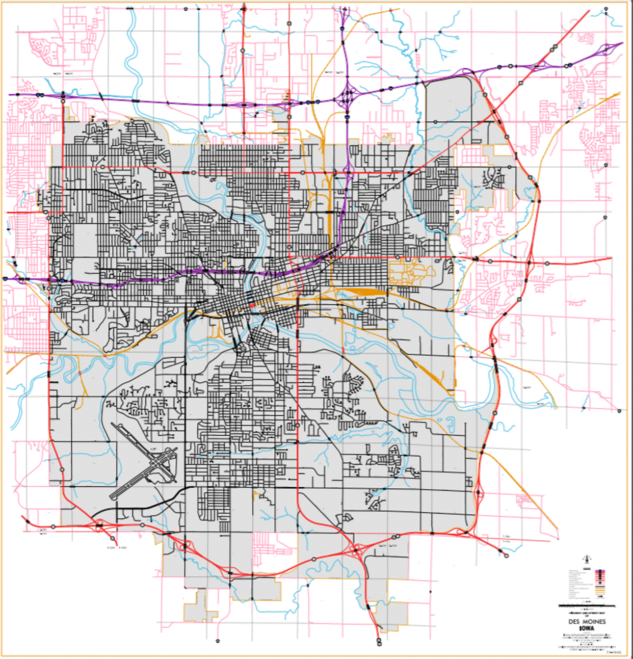
Des Moines:
Beginning on an unnamed
street at the south corporation line; thence northwest on an unnamed street to
SE 14th Street; thence north on SE 14th Street to unnamed street (begin one-way
northbound); thence northeast on unnamed street to E 15th Street; thence north
to E 15th Street to unnamed street; thence northwest on unnamed street to E
14th Street (end one-way northbound); thence north on E 14th Street to
University Avenue (junction US 65, 69 and Iowa 163); thence east on University
Avenue to the east corporation line of Des Moines (west corporation line of
Pleasant Hill).
Also
Beginning at unnamed
street on E 14th Street
(begin one-way southbound); thence south on E 14th Street to unnamed street (end
one-way southbound).
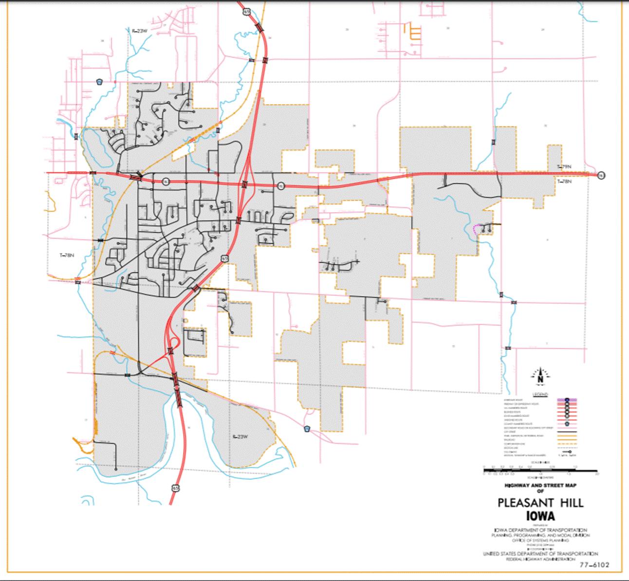
Pleasant Hill:
Beginning on University
Avenue at the west corporation line of Pleasant Hill (east corporation line of
Des Moines); thence east along University Avenue until connecting with an
unnamed street; thence southeast and east to the east junction of Iowa 163;
thence north on unnamed street to north corporation line of Pleasant Hill.
Beginning
again at the north corporation line of Pleasant Hill connecting with unnamed
street; thence north through Sections 35 and 26 to near Center Section
26-T79N-R23W; thence northwest through Sections 26, 23, 22, and Section
15-T79N-R23W to the west corporation line of Altoona (Intersection of US 6).
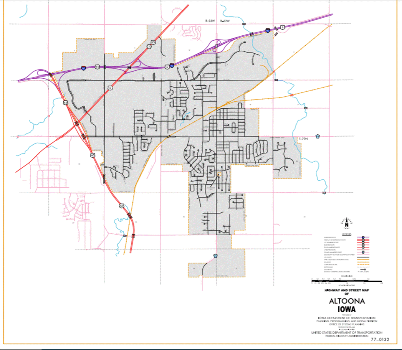
Altoona:
Beginning again on the
west corporation line of Altoona connecting with an unnamed street; thence
northwest following the west corporation line to the north corporation line of
Altoona (west junction of Interstate 80).
Beginning
again at the north corporation line of Altoona; thence easterly on Interstate
80 through Sections 10 and 11 to near E ¼ Corner SW ¼ of Sections 11-T79N-R23W
(east junction of Interstate 80 and junction of US 6); thence northeasterly
through Sections 11, 12 and 1-T79N-R23W to the south corporation line of
Bondurant, connecting with an unnamed street.
Bondurant:
Beginning on unnamed
street at the south corporation line; thence northeast on unnamed street to the
east corporation line.
Beginning
again on the east corporation line of Bondurant connecting with an unnamed
street; thence northeast through Sections 32, 29, 28, 21, 16, 15, 10, 11, 2 and
1-T80N-R22W and Section 36-T81N-R22W to the Polk-Jasper County line at a point
approximately 183 meters (600 feet) north of the SE Corner Section
36-T81N-R22W, Polk County (SW Corner Section 31-T81N-R21W, Jasper County).
PROPOSAL/ACTION
RECOMMENDATION:
It
is recommended to approve revising the description of US 65 in Polk County to
include the attached new description in the Primary Road System.
STAFF
ACTION
OFFICE: Transportation Data
SUBMITTED
BY: Patrick R. Cain
SUBMITTAL
DATE:
07-23-96
TITLE: Official Description Change: US
65 in Polk County
DISCUSSION/BACKGROUND:
Due
to the relocation of US 65 in Polk County on December 21, 1994, the official
description of this route should be revised to reflect the new alignment.
At
the same time the old section of US 65 between the new junction of US 6/56
northeasterly to the Interstate 80 interchange went back to Polk County
and the City of Altoona.
New
Description - US 65 and its extensions in Polk County
described as follows:
Beginning on the Polk-Warren County
line near the SE Corner Section 35-T78NR24W,
Polk County
(NE Corner Section 2-T77N-R24W, Warren County);
thence in a general northwesterly direction through Section 35-T78N-R24W to the
south corporation line of Des Moines,
connecting with an unnamed street.
Des Moines:
Beginning on an unnamed
street at the south corporation line; thence northwest on an unnamed street to
SE 14th Street; thence north on SE 14th Street to unnamed street (begin one-way
northbound); thence northeast on unnamed street to E 15th Street; thence north
on E 15th Street to unnamed street; thence northwest on unnamed street to E
14th Street (end one-way northbound); thence north on E 14th Street to
University Avenue (junction US 65, 69 and Iowa 163); thence east on University
Avenue to the east corporation line of Des Moines (west corporation line of
Pleasant Hill).
Also
Beginning
at unnamed street on E 14th Street
(begin one-way southbound); thence south on E 14th Street to unnamed street (end
one-way southbound).
Pleasant Hill:
Beginning on University
Avenue at the west corporation line of Pleasant Hill (east corporation line of
Des Moines); thence east along University Avenue until connecting with an
unnamed street; thence southeast and east to the east junction of Iowa 163;
thence north on unnamed street to north corporation line of Pleasant Hill.
Beginning again at the
north corporation line of Pleasant Hill connecting with unnamed street; thence
north through Sections 35 and 26 to near Center Section 26-T79N-R23W; thence
northwest through Sections 26, 23, 22, and Section 15-T79NR23W to the west
corporation line of Altoona (junction of US 6).
Altoona:
Beginning again at the
west corporation line of Altoona on unnamed
street; thence northwest following the west corporation line to the north
corporation line of Altoona
(west junction of Interstate 80 and US 6).
Beginning
again at the north corporation line of Altoona; thence easterly on Interstate
80 through Sections 10 and 11 to near E ¼ corner SW ¼ of Sections 11-T79N-R23W (east junction
of Interstate 80 and US 6); thence northeasterly through Sections 11, 12 and
1-T79N-R23W to the south corporation line of Bondurant, connecting with an
unnamed street.
Bondurant:
Beginning on unnamed
street at the south corporation line; thence northeast on unnamed street to the
east corporation line.
Beginning
again on the east corporation line of Bondurant connecting with an unnamed
street; thence northeast through Sections 32, 29, 28, 21, 16, 15, 10, 11, 2 and 1-T80N-R22W and Section
36-T81N-R22W to the Polk-Jasper County line at a point approximately 600 feet
north of the SE Corner Section 36-T81N-R22W, Polk County (SW Corner Section
31-T81N-R21W, Jasper County).
PROPOSAL/ACTION
RECOMMENDATION:
It is recommended to
approve revising the description of US 65 in Polk County to include the
attached new description in the Primary Road System.
OFFICIAL
DESCRIPTION CHANGE
COUNTY: Polk
ROUTE: US 65
STAFF
ACTION NUMBER: S-87-1518
APPROVAL
DATE: 5-13-87
New
Description - US 65 and its extensions in Polk County
described as follows:
Beginning
on the Polk‑Warren County line near the SE Corner Section 35‑T78N‑R24W,
Polk County (NE Corner Section 2‑T77N‑R24W, Warren County); thence
in a general northwesterly direction through Section 35‑T78N‑R24W
to the east corporation line of Des Moines, connecting with an unnamed street.
Des Moines:
Beginning
on an unnamed street at the east corporation line; thence northwest an unnamed
street to SE 14th Street; thence north on SE 14th Street to Johnson Street
(begin one‑way northbound); thence northeast on Johnson Street to E 15th
Street; thence north on E 15th Street to unnamed street; thence northwest on
unnamed street to E 14th Street (end one‑way northbound); thence north on
E 14th Street to Euclid Avenue; thence east on Euclid Avenue to Frederick M
Hubbell Avenue; thence northeast on Frederick M Hubbell Avenue to the north
corporation line.
Also
Beginning
at unnamed street on E 14th Street
(begin one‑way southbound); thence south on E 14th Street to Johnson Street (end one‑way
southbound).
Beginning
again on the north corporation line of Des Moines
connecting with Frederick M Hubbell Avenue; thence northeast through Sections
21, 22 and 15‑T79N‑R23W to the west corporation line of Altoona connecting with
an unnamed street.
Altoona:
Beginning
on the west corporation line connecting with an unnamed street; thence
northeast to the north corporation line, connecting with an unnamed street.
Beginning
again on the north corporation line of Altoona
connecting with an unnamed street; thence northeast through Sections 11
(Interstate 80 interchange), 12 and 1‑T79N‑R23W to the south
corporation line of Bondurant, connecting with an unnamed street.
Bondurant:
Beginning
on unnamed street at the south corporation line; thence northeast on unnamed
street to the east corporation line.
Beginning
again on the east corporation line of Bondurant connecting with an unnamed
street; thence northeast through Sections 32, 29, 28, 21, 16, 15, 10, 11, 2 and
1‑T80N‑R22W and Section 36‑T81N‑R22W to the Polk‑Jasper
County line at a point approximately 600 feet north of the SE Corner Section 36‑T81N‑R22W,
Polk County (SW Corner Section 31‑T81N‑R21W, Jasper County).
COMMISSION
ORDER
DIVISION: Planning & Research
COMMISSION
ORDER NUMBER: PR-79-272
SUBMITTED
BY: C.I.
MacGillivray
MEETING
DATE: 11-2-78
TITLE: US
65, Polk County, Iowa
DISCUSSION/BACKGROUND:
Due
to a review of our Primary Road System records US
65 in Polk County should be deleted and the new
description added should be officially included into the Primary System.
US
65 begins on the Polk‑Warren County line approximately 5 miles west of
Carlisle, and travels generally northwesterly and northeasterly via Des Moines,
Altoona and Bondurant to the Polk‑Jasper County line approximately 6
miles south of the NE Corner of Polk County, Iowa.
PROPOSAL/ACTION
RECOMMENDATION:
Locate
US 65 and its extensions in Polk
County as follows;
Beginning
on the Polk‑Warren County line near the SE Corner Section 35‑T78N‑R24W,
Polk County (NE Corner Section 2‑T77N‑R44W, Warren County); thence
in a general northwesterly direction through Section 35‑T78N‑R24W
to the east corporation line of the City of Des Moines connecting with an
unnamed street.
Des Moines:
Beginning on the east
corporation line connecting with an unnamed street; thence northerly, easterly
and northeasterly to the east corporation line connecting with an unnamed
street.
Also
Beginning at Fremont Street on E 14th Street (begin
one‑way southbound); thence south on E 14th Street to Vine Street (end one‑way
southbound).
Beginning
again on the east corporation line of the City of Des Moines connecting with an
unnamed street; thence in a northeasterly direction through Sections 21, 22 and
15‑T79N‑R23W to the west corporation line of the City of Altoona
connecting with an unnamed street.
Altoona:
Beginning on the west
corporation line connecting with an unnamed street; thence northeasterly to the
north corporation line connecting with an unnamed street.
Beginning
again on the north corporation line of the City of Altoona connecting with an
unnamed street; thence in a northeasterly direction through Sections 11
(Interstate 80 interchange), 12 and 1‑T79N‑R23W to the south
corporation line of the City of Bondurant connecting with an unnamed street.
Bondurant:
Beginning on the south
corporation line connecting with an unnamed street; thence northeasterly to the
east corporation line connecting with an unnamed street.
Beginning
again on the east corporation line of the City of Bondurant connecting with an
unnamed street; thence northeasterly through Sections 32, 29, 28, 21, 16, 15,
10, 11, 2 and 1‑T80N‑R22W and Section 36‑T81N‑R22W to
the Polk‑Jasper County line at a point approximately 600 feet north of
the SE Corner Section 36‑T81N‑R22W, Polk County (SW Corner Section
31‑T81N‑R21W, Jasper County).
NOW,
THEREFORE: Be it resolved that the Iowa
Department of Transportation approve the location of US 65 in Polk County, Iowa.
NOTE: To become effective upon the adoption of this
resolution.
REVISED: 5-13-87
COMMISSION
RESOLUTION
DIVISION: Planning & Research
COMMISSION
ORDER NUMBER: 74-498
SUBMITTED
BY: Gene R. Mills
MEETING
DATE: 5-1-74
TITLE: Approving the location of US 65 and its
extensions in Polk County, Iowa
Locate
US 65 and its extensions in Polk
County, Iowa as
follows:
Beginning
at the Polk‑Warren County line near the SE Corner Section 35-T78N-R24W, Polk County
(NE Corner Section 2‑T77N‑R24W, Warren
County); thence northwesterly to the
east corporation line of the City of Des
Moines connecting with an unnamed street.
Des Moines:
Commencing
on unnamed street at the east corporation line; thence northwesterly to SE 14th
Street; thence northerly on SE 14th Street to Vine Street (begin one‑way
northbound); thence northeasterly to E 15th Street; thence northerly on E 15th
Street to Walker Street; thence northwesterly to E 14th Street (end one‑way
northbound); thence north on E 14th Street to Euclid Avenue; thence east on
Euclid Avenue to Frederick M Hubbell Avenue; thence northeasterly on Frederick
M Hubbell Avenue to the north corporation line.
Also
Commencing
at Fremont Street
on E 14th Street
(begin one‑way southbound); thence south on E 14th Street to Vine Street (end one‑way
southbound).
Beginning
again on the east corporation line of the City of Des Moines connecting with
Frederick M Hubbell Avenue; thence in a northeasterly direction through
Sections 21, 22, 15, 14, 11, and 12‑T79N‑R23W to the south
corporation line of the Town of Bondurant connecting with an unnamed street.
Bondurant
Commencing
on unnamed street at the south corporation line; thence northeasterly on
unnamed street to the east corporation line.
Beginning
again on the east corporation line of the Town of Bondurant connecting with an
unnamed street; thence in a northeasterly direction through Section 32, 29, 28,
21, 16, 15, 10, 11, 2 and 1‑T80N‑R22W and Section 36‑T81N‑R22W
to the Polk-Jasper County line at a point approximately 600 feet north of the
SE Corner Section 36T81N‑R22W, Polk County (SW Corner Section 31‑T81N‑R21W,
Jasper County).
NOW,
THEREFORE: Be it resolved that the Iowa
State Highway Commission approve the location of US 65 and its extensions in Polk County, Iowa.
Note: To become effective upon adoption of this
resolution.
OFFICIAL
DESCRIPTION CHANGE
COUNTY: Polk
ROUTE: US 65
APPROVAL
DATE: 7-28-42
Beginning
at the Polk-Warren County line at a point near the SE Corner Section
35-T78-R24 Polk County (NW Corner Section 1-T77-R24 Warren
County); thence northwesterly through Section 35-T78-R24 to the east
corporation line of the City of Des
Moines connecting with E 14th Street.
Beginning
again on the east corporation line of the City of Des
Moines, connecting with Frederick M Hubbell Avenue; thence in a
northeasterly direction through Section 21, 22, 15, 14, 11, 12, and 1-T79-R23
to the south corporation line of the Town of Bondurant connecting with an unnamed street.
Beginning
again on the east corporation line of the Town of Bondurant, connecting with an
unnamed street; thence in a northeasterly direction through Section 32, 29, 28,
21, 16, 15, 10, 11, 2 and 1-T80-R22 and Section 36-T81-R22 to the Polk-Jasper
County line at a point approximately 600 feet north of the SE Corner Section
36-T81-R22 Polk County (SW Corner Section 31-T81-R21 Jasper County).
OFFICIAL
DESCRIPTION CHANGE
COUNTY: Polk
CITY
OF: Des
Moines
ROUTE: US 65
APPROVAL
DATE: 7-28-42
Commencing
on unnamed street at the east corporation line; thence northwesterly and
northerly on E 14th Street to Euclid Avenue; thence easterly on Euclid Avenue
to Frederick M Hubbell Avenue; thence northeasterly on Frederick M Hubbell
Avenue to the east corporation line.
OFFICIAL
DESCRIPTION CHANGE
COUNTY: Polk
CITY
OF: Bondurant
ROUTE: US 65
APPROVAL
DATE: 1-7-41
Commencing
on unnamed street at the south corporation line; thence northeasterly on
unnamed street to the east corporation line.