OFFICIAL
DESCRIPTION CHANGE
OFFICE:
Transportation Data
ENTERED
BY: Stefani Wonders
ENTERED
DATE: 09-14-2006
DISCUSSION/BACKGROUND:
Due to a
review of our Primary System records, the primary route description for
Interstate 80 in Polk
County was found to be in
slight error and therefore was re-written.
PROPOSAL/ACTION
RECOMMENDATION:
New
Description - Interstate 80 and its extensions in Polk County
described as follows:
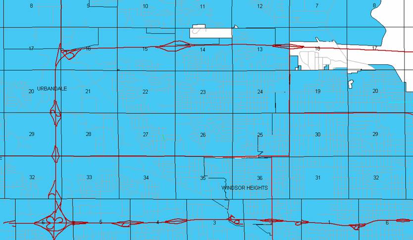
West Des Moines:
Beginning on
an unnamed street at the west corporation line (Polk‑Dallas County line)
at a point near the W ¼ Corner Section 6‑T78N‑R25W, Polk County (E
¼ Corner Section 1-T78N-R26W, Dallas County); thence easterly on unnamed street
to a point approximately 1318 feet east of the center of Section 6‑T78N‑R25W
connecting with Interstate 35; thence northerly through said Section 6 to the
north corporation line/south corporation line of Clive connecting with an
unnamed street (approximately 2036 feet west of the NE Corner of said Section
6).
Clive:
Beginning on
an unnamed street at the south corporation line; thence northerly on said
unnamed street to the north corporation line/south corporation line of Urbandale connecting with
an unnamed street (approximately 684 feet west of the NE Corner Section 32-T78N-R25W).
Urbandale:
Beginning on
an unnamed street at the south corporation line; thence northerly,
northeasterly, and easterly on said unnamed street through Sections 29, 20, 17,
16, 15, 14, and 13‑T79N‑R25W to the east corporation line (a point
near the E ¼ Corner of said Section 13).
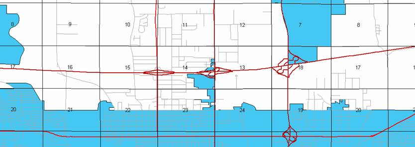
Beginning
again on the east corporation line of Urbandale connecting with an unnamed
street; thence easterly through Sections 18, 17, 16, and 15-T79N-R24W to a
point (junction Iowa 415) approximately 1950 feet north of the SE Corner
Section 14‑T79N‑R24W; thence easterly through Section 14‑T79N‑R24W
to a point (junction US 69) approximately 2100 feet north of the SE Corner
Section 14‑T79N‑R24W; thence easterly through Section 13‑T79N‑R24W
and Section 18‑T79N‑R23W to a point (junction Interstate 35 and Interstate
235) approximately 2085 feet east of the W ¼ Corner Section 18-T79N‑R23W;
thence easterly and northeasterly through Sections 18, 17, 16, 9, and 10‑T79N‑R23W
to the west corporation line of Altoona connecting with an unnamed street
(approximately 544 feet north and 472 feet east of the SW Corner of said
Section 10).
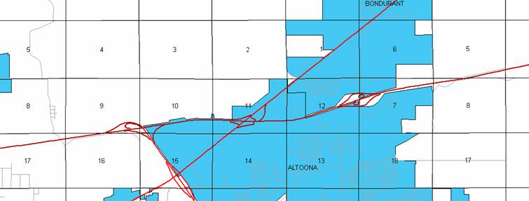
Altoona:
Beginning on
an unnamed street at the west corporation line; thence easterly on said unnamed
street to the east corporation line (approximately 1477 feet north and 1808
feet east of the SW Corner Section 12-T79N-R23W).
Beginning
again on the east corporation line of Altoona connecting with an unnamed
street; thence northeasterly through
Section 12‑T79N‑R23W and Sections 7, 8, 5, and 4‑T79N‑R22W
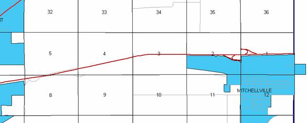
to a point approximately 360 feet south of the E ¼ Corner of Section 4‑T79N‑R22W;
thence curving easterly and following substantially the center section line
through Sections 3, 2, and 1‑T79N‑R22W to the Polk‑Jasper
County line at a point near the E ¼ Corner Section 1-T79N-R22W, Polk County (W
¼ Corner Section 6‑T79N‑R21W, Jasper County).
COMMISSION
ORDER
DIVISION:
Planning & Research
COMMISSION
ORDER NUMBER:
PR-79-272
SUBMITTED
BY: C.I. MacGillivray
MEETING
DATE: 11-2-78
DISCUSSION/BACKGROUND:
Due to a review
of our Primary Interstate system records, Interstate 80 in Polk County
should be deleted and the new description added should be officially included
into the Primary Interstate System.
Interstate
80 begins on the corporation line of West Des Moines
(Polk‑Dallas County line) approximately ½ mile south of the NW Corner of West Des Moines, and travels northerly and east‑northeasterly
via West Des Moines, Urbandale,
and Johnston to the Polk‑Jasper County
line approximately ½ mile north of Mitchellville,
Iowa.
PROPOSAL/ACTION
RECOMMENDATION:
Locate
Interstate 80 and its extensions in Polk
County as follows:
West Des Moines:
Beginning on
an unnamed street at the west corporation line (Polk‑Dallas County line)
at a point near the W ¼ Corner Section 6‑T78N‑R25W, Polk County (E
¼ Corner Section 1-T78N-R26W, Dallas County); thence easterly on unnamed street
to a point approximately 1000 feet east of the center of Section 6‑T78N‑R25W;
thence northerly through said Section 6 to the north corporation line connecting
with an unnamed street.
Beginning
on the north corporation line of the City of West Des
Moines connecting with an unnamed street; thence in a northerly
direction through Section 32‑T78N‑R25W to the south corporation
line of the City of Urbandale
connecting with an unnamed street.
Urbandale:
Commencing
on an unnamed street at the south corporation line; thence northerly on said
unnamed street through Sections 29 and 20‑T79N‑R25W to the north
corporation line connecting with an unnamed street.
Beginning
again at the north corporation line of the City of Urbandale connecting with an
unnamed street; thence curving in a northeasterly direction through the SE ¼ of
Section 17‑T79N‑R25W and the SW ¼ of Section 16‑T79N‑R25W
to a point (junction Iowa 141) in the SW ¼ of said Section 16; thence curving
in a northeasterly and easterly direction through Sections 16, 15, and 14‑T79N‑R25W
to the westerly corporation line of the City of Urbandale connecting with an unnamed street.
Urbandale:
Commencing
again on an unnamed street at the westerly corporation line; thence easterly on
said unnamed street through Sections 14 and 13‑T79N‑R25W to the
east corporation line (west corporation line of the City of Johnston) connecting with an unnamed street.
Johnston:
Beginning on
the west corporation line (east corporation line of the City of Urbandale) connecting with
an unnamed street; thence easterly through Section 18‑T79N‑R24W to
the east corporation line connecting with an unnamed street.
Beginning
again on the east corporation line of the City of Johnston connecting with an
unnamed street; thence easterly through Sections 18, 17, 16, and 15-T79N-R24W
to a point (junction Iowa 415) approximately 1950 feet north of the SE Corner
Section 14‑T79N‑R24W; thence in a generally easterly direction
through Section 14‑T79N‑R24W to a point (junction US 69)
approximately 1850 feet north of the SE Corner Section 14‑T79N‑R24W;
thence in a generally easterly direction through Section 13‑T79N‑R24W
and Section 18‑T79N‑R23W to a point (junction Interstate Routes 35
and 235) approximately ¼ mile east of the W ¼ Corner Section 18-T79N‑R23W;
thence east‑northeasterly through Sections 18, 17, and 16‑T79N‑R23W
to a point approximately 172 feet east of the N ¼ Corner Section 16‑T79N‑R23W,
and continuing in a northeasterly and easterly direction through Sections 9,
10, and 11‑T79N‑R23W (junction US 65) to a point approximately 1182
feet north of the SE Corner of said Section 11; thence northeasterly through
Section 12‑T79N‑R23W and Sections 7, 8, 5, and 4‑T79N‑R22W
to a point approximately 360 feet south of the E ¼ Corner of Section 4‑T79N‑R22W;
thence curving easterly and following substantially the center section line
through Sections 3, 2, and 1‑T79N‑R22W to the Polk‑Jasper
County line at a point approximately 136 feet north of the E ¼ Corner Section
1-T79N-R22W, Polk County (W ¼ Corner Section 6‑T79N‑R21W, Jasper
County).
NOW,
THEREFORE: Be it resolved that the Iowa
Department of Transportation approve the location of Interstate 80 in Polk County, Iowa.
NOTE: To become effective upon the adoption of this
resolution.
COMMISSION
ORDER
DIVISION:
Planning & Research
SUBMITTED
BY: Raymond L. Kassel
MEETING
DATE: 3-9-76
DISCUSSION/BACKGROUND:
Due to a
review of our Primary Interstate Highway System records, Interstate 80 in Urbandale, Polk
County should be deleted
from the Primary Interstate Road Extension and the new description added should
be officially included into the Primary Interstate Road Extension.
PROPOSAL/ACTION
RECOMMENDATION:
Locate
Interstate 80 in Urbandale, Polk County
as follows:
Commencing
on an unnamed street at the south corporation line; thence northerly on said unnamed
street through Sections 29 and 20‑T79N‑R25W to the north corporation
line.
Commencing
again on an unnamed street at the west corporation line; thence easterly on
said unnamed street through Sections 14 and 13‑T79N‑R25W to the
east corporation line.
NOW,
THEREFORE: Be it resolved that the Iowa
Department of Transportation approve the revision of Interstate 80, Urbandale,
Polk County, Iowa.
NOTE: To
become effective upon adoption of this resolution.
COMMISSION
RESOLUTION
DIVISION:
Planning & Research
COMMISSION
ORDER NUMBER: 74-500
SUBMITTED
BY: Gene R. Mills
MEETING
DATE: 5-1-74
Locate
Interstate 80 and its extensions in Polk
County as follows:
Beginning
on the north corporation line of the City of West Des
Moines connecting with an unnamed street; thence in a northerly
direction through Section 32 to the south corporation line of the City of Urbandale.
Urbandale:
Commencing on
an unnamed street at the south corporation line; thence northerly on said
unnamed street through Section 14 and 13‑T79N‑R25W to the north
corporation line.
Beginning
again at the north corporation line of the City of Urbandale connecting with an
unnamed street; thence curving in a northeasterly and easterly direction
through the SE ¼ of Section 17‑T79N‑R25W and the SW ¼ of Section 16‑T79N‑R25W
to a point near the center of Section 16-T79N‑R25W; thence in an easterly
direction through Sections 16, 15 and 14 to the west corporation line of
Urbandale connecting with an unnamed street.
Urbandale:
Commencing
again on an unnamed street at the west corporation line; thence easterly on
said unnamed street through Sections 14 and 13‑T79N‑R25W to the
east corporation line.
Beginning
again at the east corporation line of Urbandale connecting with an unnamed
street; thence easterly through Sections 18, 17, 16, 15, 14 and 13-T79N-R24W
and Section 18‑T79N‑R23W to a point approximately ¼ mile east of
the W ¼ Corner Section 18-T79N-R23W thence east‑northeasterly through
Sections 18, 17 and 16-T79N-R23W to a point approximately 172 feet east of the
N ¼ Corner of Section 16‑T79N‑R23W, and continuing in a
northeasterly and easterly direction through Sections 9, 10 and 11‑T79N‑R23W
to a point approximately 1182 feet north of the SE Corner of Section 11‑T79N‑R23W;
thence northeasterly through Section 12‑T79N‑R23W and Sections 7,
8, 5 and 4‑T79N‑R22W to a point approximately 360 feet south of the
E ¼ Corner of Section 4‑T79N‑R22W; thence curving easterly and
following substantially the quarter section line through Sections 3, 2 and 1‑T79N‑R22W
to the Polk‑Jasper County line at a point approximately 136 feet north of
the E ¼ Corner Section 1‑T79N‑R22W, Polk County
(W ¼ Corner Section 6‑T79N‑R21W, Jasper County).
NOW,THEREFORE:
Be it resolved that the Iowa State Highway Commission approve the location of
Interstate 80 and its extensions in Polk County, Iowa.
NOTE: To
become effective upon the adoption of this resolution.
OFFICIAL
DESCRIPTION CHANGE
COUNTY:
Polk
ROUTE:
Interstate 80
APPROVAL
DATE: 1-29-64
West Des Moines:
Commencing
on an unnamed street at the west corporation line (Polk‑Dallas County
line) at a point approximately 100 feet north of the W ¼ Corner Section 6‑T78N‑R25W,
Polk County (E ¼ Corner Section 1‑T78N‑R26W, Dallas County); thence
east on said unnamed street to a point approximately 1,000 feet east and 100
feet north of the center of Section 6‑T78N‑R25W; thence northerly
on an unnamed street to the north corporation line.
Beginning on
the north corporation line of the City of West Des Moines connecting with an
unnamed street thence north through Section 32-79-25 to the south corporation
line of Urbandale; thence in a northerly direction through Sections 29 and
20-T79N-R25W to a point approximately 560 feet west of the SE Corner of Section
17‑T79N‑R25W; thence curving in a northeasterly and easterly
direction through the SE ¼ of Section 17-T79N-R25W and the SW ¼ of Section 16‑T79N‑R25W
to a point near the center of Section 16-T79N-R25W; thence in an easterly
direction through Sections 16, 15 and 14‑T79N‑R25W to the west
corporation line of Urbandale connecting with an unnamed street.
Beginning on
the east corporation line connecting with unnamed street thence easterly
through Sections 18, 17, 16, 15, 14 and 13‑T79N‑R24W and Section 18‑T79N‑R23W
to a point approximately ¼ mile east of the W ¼ Corner of Section 18‑T79N‑R23W;
thence east‑northeasterly through Sections 18, 17 and 16‑T79N-R23W
to a point approximately 172 feet east of the N ¼ Corner of Section 16‑T79N‑R23W
and continuing in a northeasterly and easterly direction through Sections 9. 10
and 11-T79N‑R23W to a point approximately 1182 feet north of the SE
Corner of Section 11‑T79N‑R23W; thence northeasterly through
Section 12‑T79N‑R23W and Sections 7, 8, 5 and 4‑T79N‑R22W
to a point approximately 360 feet south of the E ¼ Corner of Section 4‑T79N‑R22W;
thence curving easterly and following substantially the quarter section line
through Sections 3, 2 and 1-T79N‑R22W to the Polk‑Jasper County
line at a point approximately 136 feet north of the E ¼ Corner of Section
l-T79N‑R22W, Polk County (W ¼ Corner of Section 6-T79N‑R21W, Jasper
County).