OFFICIAL
DESCRIPTION CHANGE
OFFICE:
Transportation Data
ENTERED
BY: Stefani Wonders
ENTERED DATE: 09-07-2006
New
Description – Interstate 35 and its extensions in Polk County
described as follows:
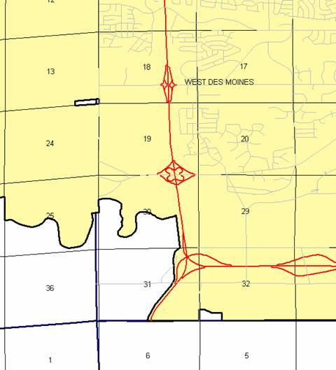
West Des Moines:
Beginning on
the Polk-Warren County line (south corporation line) at a point near the S ¼
Corner Section 31‑T78N‑R25W, Polk County (N ¼ Corner Section 6‑T77N‑R25W,
Warren County) connecting with an unnamed street; thence curving in a
northeasterly, northerly, northwesterly, and northerly direction on said
unnamed street through Sections 31, 30, 19, 18, 7, and 6-T78N-R25W to the north
corporation line (south corporation line of Clive) (approximately 2105 feet
west of the NE Corner of said Section 6) connecting with an unnamed street.
Clive:
Beginning on
an unnamed street at the south corporation line (north corporation line of West
Des Moines); thence northerly on said unnamed street through Sections
32-T79N-R25W to the north corporation line (south corporation line of Urbandale)
(a point approximately 679 feet west of the NE Corner of said Section 32)
connecting with an unnamed street.
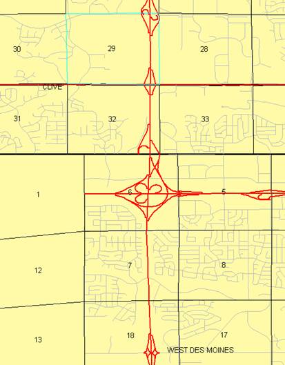
Urbandale:
Beginning on
an unnamed street at the south corporation line (north corporation line of
Clive); thence northerly on said unnamed street through Sections 29, and
20-T79N-R25W to a point approximately 653 feet west of the NE Corner of said
Section 20; thence northeasterly and easterly through Sections 17 and
16-T79N-R25W to a point near the Center of said Section 16; thence easterly
through Sections 16, 15, 14, and 13-T79N-R25W to the east corporation line (a
point near the Center of said Section 13).
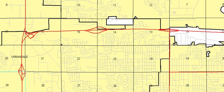
Beginning
again on the east corporation line connecting with an unnamed street; thence
easterly through Sections 18, 17, 16, 15, 14, and 13-T79N-R24W; thence
northeasterly through Section 18-T79N-R23W to the junction of Interstate 80 and
Interstate 235 (approximately 2026 feet east and 2283 feet south of the NW
Corner of said Section 18); thence northerly, northwesterly, and northeasterly
through Sections 18 and 7-T79N-R23W to the south corporation line of Ankeny
(approximately 1258 feet east of the NW Corner of said Section 7) connecting
with an unnamed street.
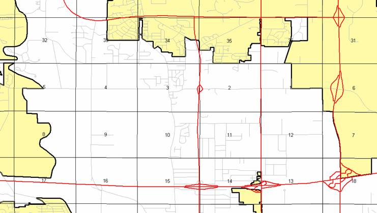
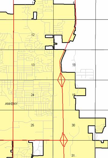
Ankeny:
Beginning on
an unnamed street at the south corporation line; thence northeasterly,
northerly, and northeasterly on said unnamed street through Section 6-T79N-R23W
and Sections 31, 30, 19, and 18-T80N-R23W to the north corporation line
(approximately 1968 feet east of the NW Corner of said Section 18).
Beginning
again on the north corporation line of Ankeny
connecting with an unnamed street; thence northeasterly through Section
7-T80N-R23W to the south corporation line of Ankeny (approximately 1296 feet north and
2567 feet east of the SW Corner of said Section 7) connecting with an unnamed
street.
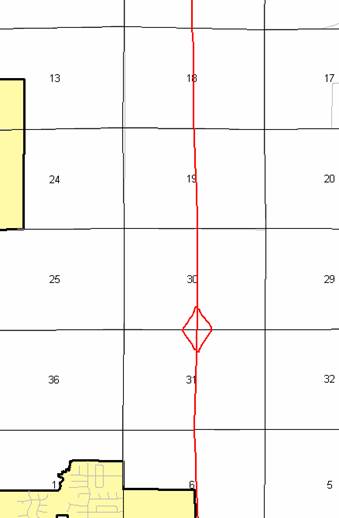
Ankeny:
Beginning on
an unnamed street at the south corporation line; thence northeasterly on said
unnamed street through Section 7-T80N-R23W to the north corporation line
(approximately 1300 feet south and 3819 feet east of the NW Corner of said
Section 7).
Beginning
again on the north corporation line of Ankeny connecting with an unnamed
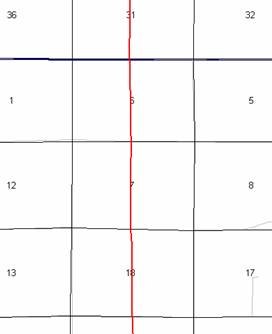
street; thence northerly through Sections 7 and 6-T80N-R23W and Sections 31,
30, 19, 18, 7, and 6-T81N-R23W to the Polk-Story County line to a point near
the N ¼ Corner of said Section 6, Polk County (S ¼ Corner Section 31-T82N–R23W,
Story County).
OFFICIAL
DESCRIPTION CHANGE
COUNTY: Polk
ROUTE:
Interstate 35
STAFF
ACTION NUMBER: 5-87-1518
APPROVAL
DATE: 5-13-87
New
Description – Interstate 35 and its extensions in Polk County
described as follows:
Beginning on
the Polk‑Warren County line at a point near the S ¼ Corner Section 31‑T78N‑R25W,
Polk County (N ¼ Corner Section 6‑T77N‑R25W, Warren County); thence
curving in a northeasterly direction through Section 31‑T78N‑R25W
to a point approximately ½ mile south and 0.3 mile west of the NE Corner
Section 31‑T78N‑R25W; thence curving in a northerly direction through
Sections 31 (junction Iowa 5) and Section 30‑T78N‑R25W to the south
corporation line of West Des Moines, connecting with an unnamed street.
West Des Moines:
Beginning on
an unnamed street at the south corporation line; thence north on said unnamed street
through Sections 30, 19, 18, 7 and 6‑T78N‑R25W to the north
corporation line connecting with an unnamed street.
Beginning
again on the north corporation line of West Des Moines
connecting with an unnamed street; thence north through Section 32‑T79N‑R25W
to the south corporation line of Urbandale
connecting with an unnamed street.
Urbandale:
Beginning on
an unnamed street at the south corporation line; thence north on said unnamed
street through Sections 29 and 20‑T79N‑R25W to the north corporation
line connecting with an unnamed street.
Beginning
again at the north corporation line of Urbandale connecting with an unnamed
street; thence curving in a northeasterly direction through the SE ¼ of Section
17‑T79N‑R25W and the SW ¼ of Section 16‑T79N‑R25W to a
point (junction Iowa 141) in the SW ¼ of said Section 16; thence curving in a
northeasterly and easterly direction through Sections 16, 15 and 14‑T79N‑R25W
to the west corporation line of Urbandale connecting with an unnamed street.
Urbandale:
Beginning
again on an unnamed street at the west corporation line; thence east on said
unnamed street through Sections 14 and 13‑T79N‑R25W to the east
corporation line (west corporation line of Johnston) connecting with an unnamed street.
Johnston:
Beginning on
the west corporation line (east corporation line of Urbandale) connecting with an unnamed street;
thence east through Section 18‑T79N‑R24W to the east corporation
line connecting with an unnamed street.
Beginning
again at the east corporation line of Johnston connecting with an unnamed
street; thence east through Sections 18, 17, 16 and 15‑T79N‑R24W to
a point (junction Iowa 415) approximately 1,950 feet north of the SE Corner
Section 14‑T79N‑R24W; thence in a generally easterly direction
through Section 14‑T79N‑R24W to a point (junction US 69)
approximately 1,850 feet north of the SE Corner Section 14‑T79N‑R24W
then in a generally easterly direction through Section 13‑T79N‑R24W
and Section 18‑T79N‑R23W to a point (junction Interstate 80 and
235) approximately ¼ mile east of the W ¼ Corner Section 18‑T79N‑R23W;
thence northerly through Sections 18, 7 and 6‑T79N‑R23W and Section
31‑T80N‑R23W to the south corporation line of Ankeny, connecting
with an unnamed street.
Ankeny:
Beginning on
an unnamed street at the south corporation line; thence north on said unnamed
street through Sections 31, 30, 19 and 18‑T80N‑R23W to the north
corporation line, connecting with an unnamed street.
Beginning
again on the north corporation line of Ankeny
connecting with an unnamed street; thence north, northeast and north through
Sections 7 and 6‑T80N‑R23W and Section 31‑T81N‑R23W to
a point approximately 2,900 feet east of the NW Corner Section 31‑T81N‑R23W;
thence north through the center part of Sections 30, 19, 18, 7 and 6‑T81N‑R23W
to the Polk‑Story County line on the north line of Section 6‑T81N‑R23W,
Polk County
(Section 31‑T82N‑R23W, Story
County).
COMMISSION
ORDER
DIVISION:
Planning & Research
COMMISSION
ORDER NUMBER:
PR-79-272
SUBMITTED
BY: C.I. MacGillivray
MEETING
DATE: 11-7-78
DISCUSSION/BACKGROUND:
Due to a
review of our Primary Interstate System Records Interstate 35 in Polk County
should be deleted and the new description added should be officially included
into the Primary Interstate System.
Interstate
35 begins on the Polk‑Warren County line approximately ½ mile east of the
SE Corner of Polk County and travels northerly, easterly and northerly via West
Des Moines, Urbandale, Johnston, and Ankeny to the Polk‑Story County line
approximately 6 miles east of Sheldahl, Iowa.
PROPOSAL/ACTION
RECOMMENDATION:
Locate
Interstate 35 and its extensions in Polk
County as follows:
Beginning on
the Polk‑Warren County line at a point near the S ¼ Corner Section
31-T78N‑R25W, Polk County (N ¼ Corner Section 6‑T77N‑R25W,
Warren County); thence curving in a northeasterly direction through Section 31‑T78N‑R25W
to a point approximately ½ mile south and 0.3 mile west of the NE Corner
Section 31‑T78N‑R25W; thence curving in a northerly direction
through Sections 31 (junction Iowa 5) and Section 30‑T78N‑R25W to
the south corporation line of the City of West Des Moines connecting with an
unnamed street.
West Des Moines:
Commencing on an unnamed street at
the south corporation line; thence northerly on said unnamed street through
Sections 30, 19, 18, 7, and 6‑T78N‑R25W to the north corporation
line connecting with an unnamed street.
Beginning
again on the north corporation line of the City of West Des
Moines and connecting with an unnamed street; thence in a northerly
direction through Section 32‑T78N‑R25W to the south corporation
line of the City of Urbandale
connecting with an unnamed street.
Urbandale:
Connecting with an unnamed street at the south
corporation line; thence northeasterly on said unnamed street through Sections
29 and 20‑T79N‑R25W to the north corporation line connecting with
an unnamed street.
Beginning
again at the north corporation line of the City of Urbandale connecting with an
unnamed street; thence curving in a northeasterly direction through the SE ½ of
Section 17‑T79N‑R25W and the SW ¼ of Section 16‑T79N‑R25W
to a point (junction Iowa 141) in the SW ¼ of said Section 16; thence curving
in a northeasterly and easterly direction through Sections 16, 15, and 14‑T79N‑R25W
to the westerly corporation line of the City of Urbandale connecting with an unnamed street.
Urbandale:
Commencing again on an unnamed street at the westerly
corporation line; thence easterly on said unnamed street through Sections 14
and 13‑T79N‑R25W to the east corporation line (west corporation
line of the City of Johnston
connecting with an unnamed street.
Johnston:
Beginning on the west corporation
line (east corporation line of the City of Urbandale connecting with an unnamed street;
thence easterly through Section 18‑T79N‑R24W to the east
corporation line connecting with an unnamed street.
Beginning
again at the east corporation line of the City of Johnston connecting with an
unnamed street; thence easterly through Sections 18, 17, 16, and 15‑T79N-R24W
to a point (junction Iowa 415) approximately 1950 feet north of the SE Corner
Section 14‑T79N‑R24W; thence in a generally easterly direction
through Section 14‑T79N‑R24W to a point (junction US 69)
approximately 1850 feet north of the SE Corner Section 14‑T79N‑R24W;
thence in a generally easterly direction through Section 13‑T79N‑R24W
and Section 18‑T79N‑R23W to a point (junction Interstate 30 and
235) approximately ¼ mile east of the W ¼ Corner Section 18‑T79N‑R23W;
thence northerly through Sections 18, 7, and 6‑T79N‑R23W and
Section 31‑T80N‑R23W to the south corporation line of the City of
Ankeny, connecting with an unnamed street.
Ankeny:
Commencing on an unnamed street at
the south corporation line; thence northerly on said unnamed street through
Sections 31, 30, 19, and 18‑T80N‑R23W to the north corporation
line, connecting with an unnamed street.
Beginning
again on the north corporation line of the City of Ankeny connecting with an
unnamed street; thence northerly, northeasterly, and northerly through Sections
7 and 6‑T80N‑R23W and Section 31‑T81N‑R23W to a point
(junction Iowa 87) approximately 2900 feet east of the NW Corner Section 31‑T81N‑R23W;
thence northerly through the center part of Sections 30, 19, 18, 7, and 6‑T81N‑R23W
to the Polk‑Story County line on the north line of Section 6‑T81N‑R23W,
Polk County (Section 31‑T82N‑R23W, Story County).
NOW,
THEREFORE: Be it resolved that the Iowa
Department of Transportation approve the location of Interstate 35 in Polk County, Iowa.
NOTE: To become effective upon the adoption of this
resolution.
REVISED:
5-13-87
COMMISSION
ORDER
DIVISION:
Planning & Research
SUBMITTED
BY: Raymond L. Kassel
MEETING
DATE: 3-9-76
DISCUSSION/BACKGROUND:
Due to a review
of our Primary Interstate Highway System records, Interstate 35 in Urbandale, Polk
County, should be deleted
from the Primary Interstate Road Extension, and the new description added
should be officially included into the Primary Interstate Road Extension.
PROPOSAL/ACTION
RECOMMENDATION:
Locate
Interstate 35 in Urbandale, Polk County
as follows:
Commencing
on an unnamed street at the south corporation line; thence northeasterly on
said unnamed street through Sections 29 and 20‑T79N‑R25W to the north
corporation line.
Commencing
again on an unnamed street at the west corporation line; thence easterly on
said unnamed street through Sections 14 and 13‑T79N‑R25W to the
east corporation line.
NOW,
THEREFORE: Be it resolved that the Iowa
Department of Transportation approve the revision of Interstate Road Extension
35, Urbandale, Polk County, Iowa.
NOTE: To become effective upon adoption of this
resolution.
COMMISSION
RESOLUTION
DIVISION:
Planning & Research
COMMISSION
ORDER NUMBER: 74-501
MEETING
DATE: 5-1-74
Locate
Interstate 35 and its extensions in Polk
County as follows:
Beginning on
the Polk‑Warren County line at a point near the S ¼ Corner Section 31-T78N‑R25W,
Polk County (N ¼ Corner Section 6‑T77N‑R25W, Warren County); thence
curving in a northeasterly direction to a point‑approximately ½ mile
south and 0.3 mile west of the NE Corner Section 31‑T78N‑R25W;
thence curving in a northerly direction to a point approximately 670 feet
south, and 990 feet west of the NE Corner Section 31‑T78N‑R25W;
thence in a northerly direction to the south corporation line of the City of
West Des Moines, connecting with an unnamed street.
Beginning
again on the north corporation line of the City of West Des
Moines connecting with an unnamed street; thence in a northerly
direction through Section 32 to the south corporation line of the City of Urbandale.
Urbandale:
Commencing
on an unnamed street at the south corporation line; thence northerly on said
unnamed street through Sections 14 and 13-T79N‑R25W to the north
corporation line.
Beginning
again at the north corporation line of the City of Urbandale connecting with
an unnamed street; thence curving in a northeasterly and easterly direction
through the SE ¼ of Section 17‑T79N‑R25W and the SW ¼ of Section 16‑T79N‑R25W
to a point near the center of Section 16‑T79N‑R25W thence in an
easterly direction through Sections 16‑15 and 14 to the westerly
corporation line of Urbandale connecting with an unnamed street.
Urbandale:
Commencing
again on an unnamed street at the west corporation line; thence east on said
unnamed street through Sections 14 and 13‑T79N‑R25W to the east
corporation line.
Beginning
again at the east corporation line of Urbandale connecting with an unnamed
street thence easterly through Sections 18, 17, 16, 15, 14 and 13-T79N‑R24W
and Section 18‑T79N‑R23W to a point approximately ¼ mile east of
the W ¼ Corner Section 18‑T79N‑R23W; thence northerly through
Sections 18, 7 and 6-T79N-R23W and Section 31‑T80N‑R23W to the
south corporation line of the Town of Ankeny,
connecting with an unnamed street.
Beginning
again on the north corporation line of the Town of Ankeny connecting with an unnamed street;
thence northerly, northeasterly and northerly through Sections 7 and 6‑T80N‑R23W
and Section 31‑T81N‑R23W to a point approximately 24 feet west of
the N ¼ Corner Section 31‑T81N‑R23W,thence northerly following
substantially the quarter section line through Sections 30, 19, 18, 7 and 6‑T81N‑R23W
to the Polk‑Story County line at a point approximately 98 feet west of
the N ¼ Corner Section 6‑T81N‑R23W, Polk County
(S ¼ Corner Section 31‑T82N‑R23W, Story County).
NOW
THEREFORE: Be it resolved that the Iowa
State Highway Commission approve the location of Interstate 35 and its
extensions in Polk County, Iowa.
NOTE: To become effective upon the adoption of this
resolution.
OFFICIAL
DESCRIPTION CHANGE
COUNTY:
Polk
ROUTE:
Interstate 35
APPROVAL
DATE: 11-28-62
Beginning on
the Polk-Warren County line at a point near the S ¼ Corner Section
31-T78N-R25W, Polk County (N ¼ Corner Section 6-T77N-R25W, Warren County);
thence curving in a northeasterly direction to a point approximately ½ mile
south and 0.3 mile west of the NE Corner Section 31-T78N-R25W; thence curving
in a northerly direction to a point approximately 670 feet south, and 990 feet
west of the NE Corner Section 31-T78N-R25W; thence in a northerly direction to
the south corporation line of the City of West Des Moines, connecting with an
unnamed street.
Beginning
again on the north corporation line of the City of West Des
Moines connecting with an unnamed street; thence north through
Section 32-T79N-R25W to the south corporation line of Urbandale.
Beginning on
the north corporation line of Urbandale; thence in a northerly direction
through Sections 29 and 20-T79N-R25W to a point approximately 560 feet west of
the SE Corner Section 17-T79N-R25W; thence curving in a northeasterly and
easterly direction through the SE ¼ of Section 17-T79N-R25W and the SW ¼ of
Section 16-T79N-R25W to a point near the center of Section 16-T79N-R25W; thence
in an easterly direction through Sections 16, 15, and 14-T79N-R25W to the west
corporation line of Urbandale connecting with an unnamed street.
Beginning on
the east corporation line connecting with an unnamed street; thence easterly
through Sections 18, 17, 16, 15, 14 and 13-T79N-R24W and Section 18-T79N-R23W
to a point approximately ¼ mile east of the W ¼ Corner Section 18-T79N-R23W;
thence northerly through Sections 18, 7 and 6-T79N-R23W and Section
31-T80N-R23W to the south corporation line of the Town of Ankeny, connecting with an unnamed street.
Ankeny:
Commencing
on an unnamed street at the south corporation line; thence northerly on said
unnamed street through Sections 31, 30, 19 and 18‑T80N‑R23W to the
north corporation line.
Beginning
again on the north corporation line of the Town of Ankeny connecting with an
unnamed street; thence northerly, northeasterly and northerly through Sections
7 and 6-T80N-R23W and Section 31-T81N-R23W to a point approximately 24 feet
west of the N ¼ Corner Section 31-T81N-R23W; thence northerly following
substantially the quarter section line through Sections 30, 19, 18, 7 and
6-T81N-R23W to the Polk-Story County line at a point approximately 98 feet west
of the N ¼ Corner Section 6-T81N-R23W, Polk County (S ¼ Corner Section
31-T82N-R23W, Story County).
OFFICIAL
DESCRIPTION CHANGE
COUNTY:
Polk
CITY OF:
West Des Moines
ROUTE:
Interstate 35
APPROVAL
DATE: 10-15-57
Commencing
on an unnamed street at the south corporation line; thence northerly on said
unnamed street through Sections 30, 19, 18, 7 and 6‑T78N‑R25W to
the north corporation line.