OFFICIAL DESCRIPTION CHANGE
OFFICE: Analytics
EFFECTIVE DATE: 1-28-2020
ENTERED BY: Paul Mauer
ENTERED DATE: 2-3-2022
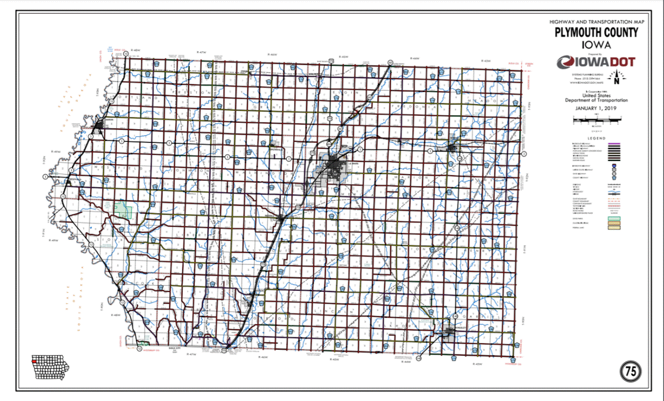
New Description ‑ US 75 and its extensions
in Plymouth County described as follows:
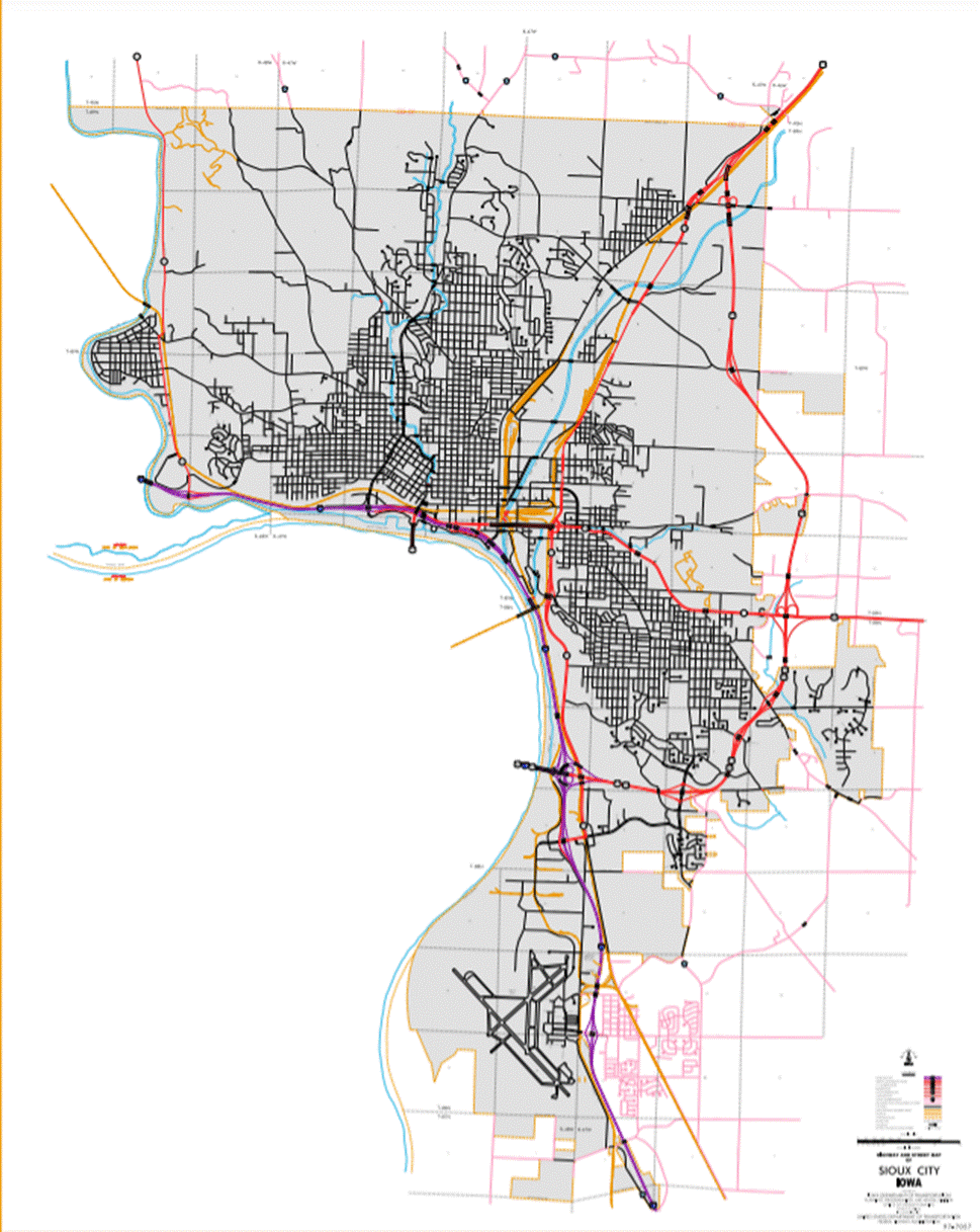
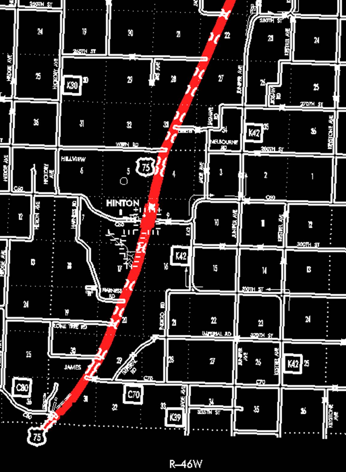
Sioux City:
Beginning on the Plymouth‑Woodbury County line connecting
with Lewis Boulevard at a point near the SW Corner Section 31‑T90N‑R46W, Plymouth County (NW
Corner Section 6‑T89N‑R46W, Woodbury County); thence in a
northeasterly direction to the north corporation line of Sioux
City (approximately 950 feet north and 900 feet east of the SW Corner
Section 31-T90N-R46W).
Beginning at the north corporation Line connecting with Lewis
Boulevard; thence northeasterly through Sections 31, 30 29, 20, 17 and 8‑T90N‑R46W
to the south corporation line of Hinton, connecting with Floyd Avenue
(approximately 1378 feet north and 184 feet west of the SE Corner of said
Section 8-T90N-R46W).
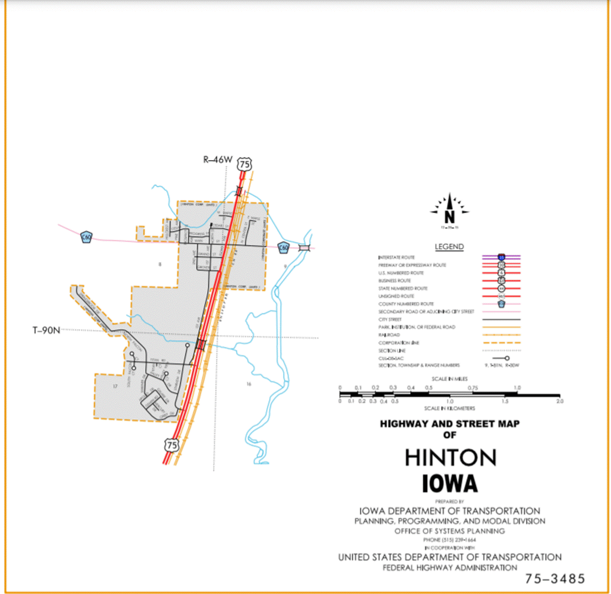
Hinton:
Beginning at the south corporation line connecting with Floyd
Avenue; thence northeasterly to the north corporation line (approximately 530 feet
east of the NW Corner Section 9-T90N-R46W).
Beginning again on the north corporation line of Hinton connecting
with Floyd Avenue; thence in a northeasterly direction through Section 4‑T90N‑R46W
and Sections 33, 28, 27, 22, 15, 10 and 11‑T91N‑R46W to the south
corporation line of Merrill, connecting with First Street (approximately 1290
feet south and 1390 feet east of the NW Corner Section 11-T91N-R46W).
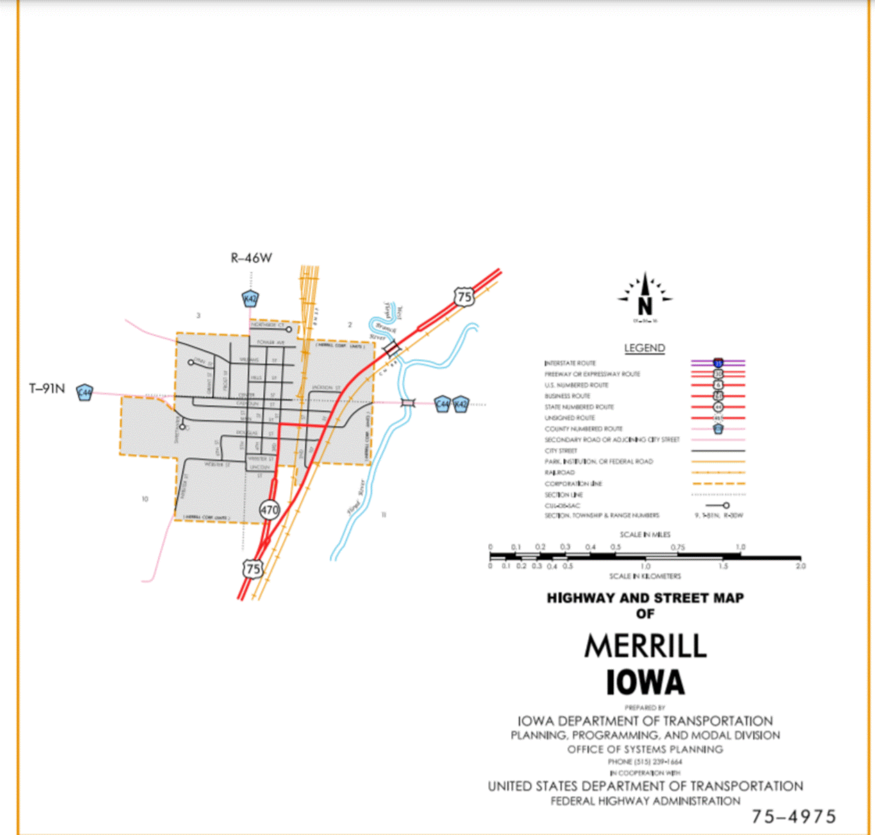
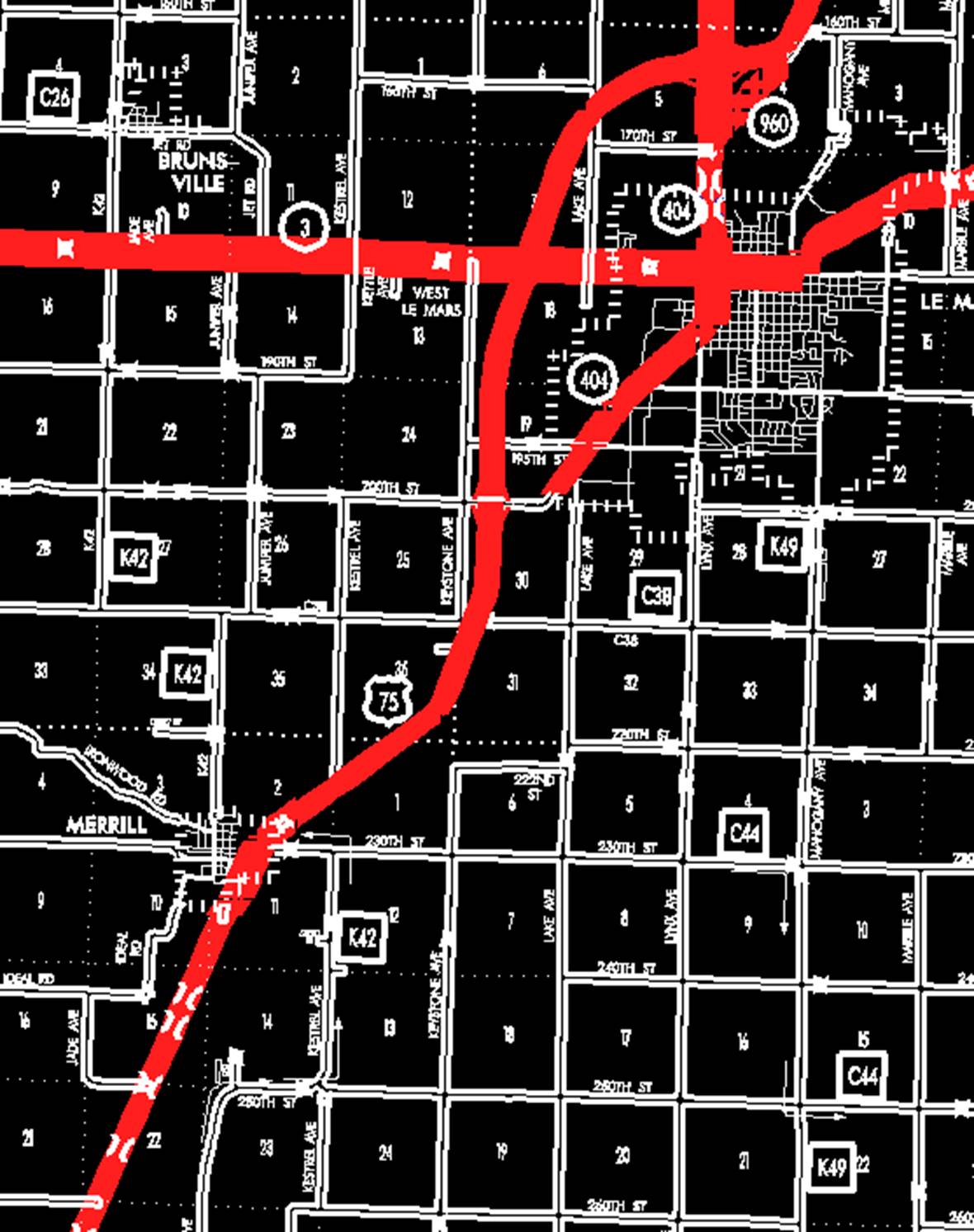
Merrill:
Beginning at the south corporation line connecting with First
Street; thence northeasterly to the east corporation line (approximately 850
feet north of the S ¼ Corner Section 2-T91N-R46W).
Beginning again on the east corporation line of Merrill connecting
with First Street; thence in a northeasterly direction through Sections 2 and 1‑T91N‑R46W,
Section 36‑T92N‑R46W and Section 31-T92N-R45W to the south
corporation line of Le Mars.
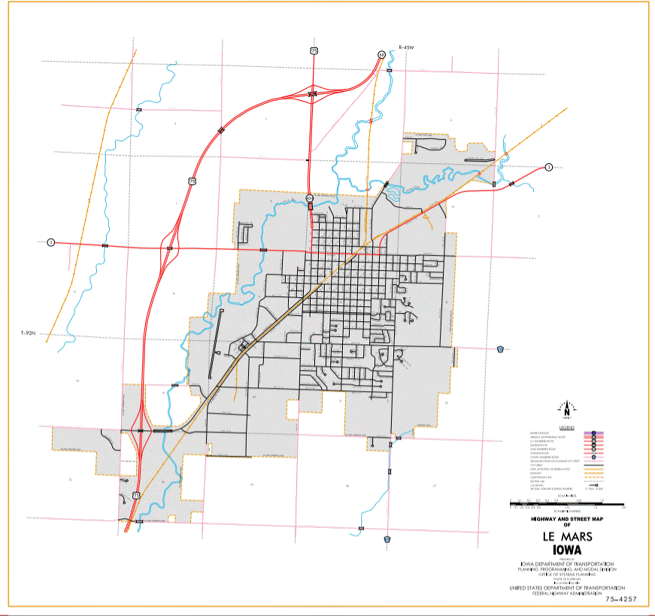
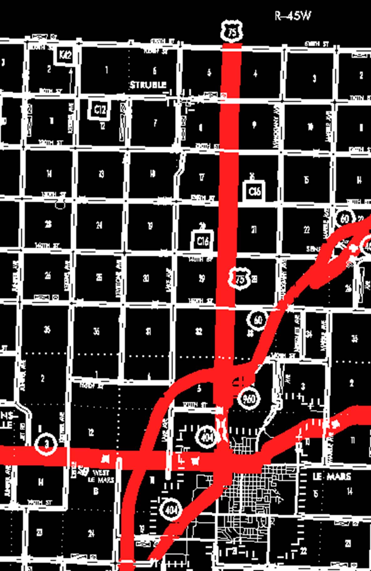
Le Mars:
Beginning at the south corporation line; thence in northeasterly
and north direction through Sections 30 and 19- T92N-R45W to the north
corporation line.
Beginning again at the north corporation line; thence
northeasterly through Sections 19, 18, 7, 6 and 5-T92N-R45W to the junction of
Iowa 60 (approximately 1480 feet south of the NE Corner Section 5-T92N-R45W);
thence northerly following substantially the section line of Section
4-T92N-R45W and Sections 33, 28, 21, 16, 9 and 4‑T93N‑R45W
to the Plymouth‑Sioux County line at a point near the NW Corner Section 4‑T93N‑R45W,
Plymouth County (SW Corner Section 33‑T94N‑R45W, Sioux County).
OFFICIAL
DESCRIPTION CHANGE
OFFICE: Analytics
EFFECTIVE
DATE: 1-29-2020
ENTERED
BY: Paul Mauer
ENTERED
DATE: 08-13-2020
New
Description ‑ US 75 and its extensions in
Beginning
on the Plymouth‑Woodbury County line connecting with
Beginning
at the north corporation Line connecting with Lewis Boulevard; thence
northeasterly through Sections 31, 30 29, 20, 17 and 8‑T90N‑R46W to
the south corporation line of Hinton, connecting with Floyd Avenue
(approximately 1378 feet north and 184 feet west of the SE Corner of said
Section 8-T90N-R46W).
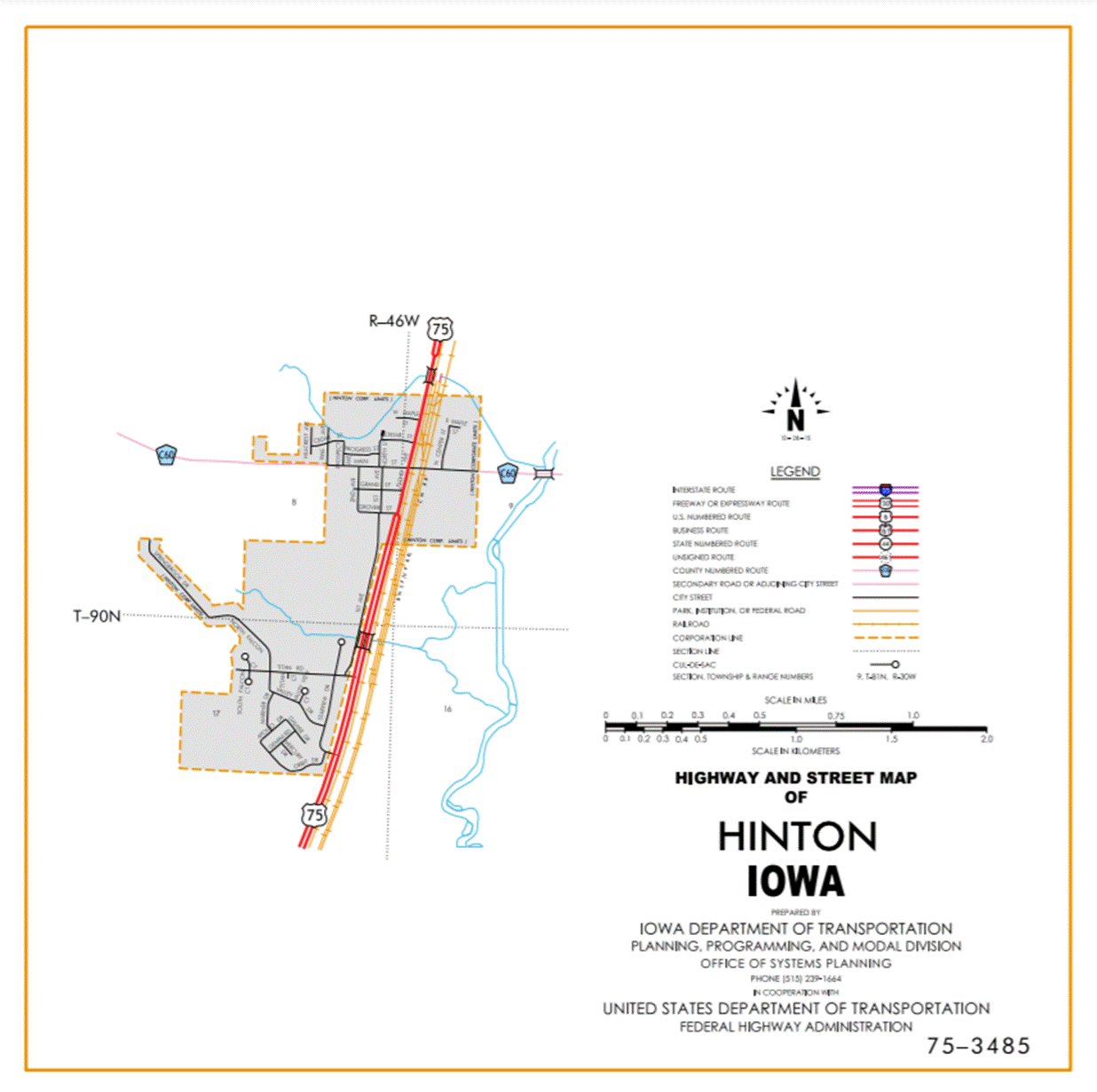
Hinton:
Beginning
at the south corporation line connecting with Floyd Avenue; thence northeasterly
to the north corporation line (approximately 1320 feet south and 280 feet east
of the NW Corner Section 9-T90N-R46W).
Beginning
again on the north corporation line of Hinton connecting with Floyd Avenue;
thence in a northeasterly direction through Sections 9 and 4‑T90N‑R46W
and Sections 33, 28, 27, 22, 15, 10 and 11‑T91N‑R46W to the south
corporation line of Merrill, connecting with First Street (approximately 1290
feet south and 1390 feet east of the NW Corner Section 11-T91N-R46W).
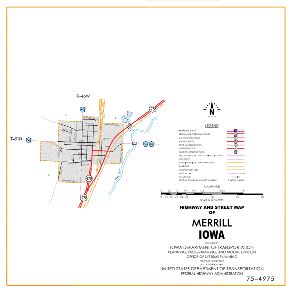
Merrill:
Beginning
at the south corporation line connecting with First Street; thence
northeasterly to the east corporation line (approximately 850 feet north of the
S ¼ Corner Section 2-T91N-R46W).
Beginning
again on the east corporation line of Merrill connecting with First Street;
thence in a northeasterly direction through Sections 2 and 1‑T91N‑R46W,
Section 36‑T92N‑R46W and Section 31-T92N-R45W to
the south corporation line of Le Mars.
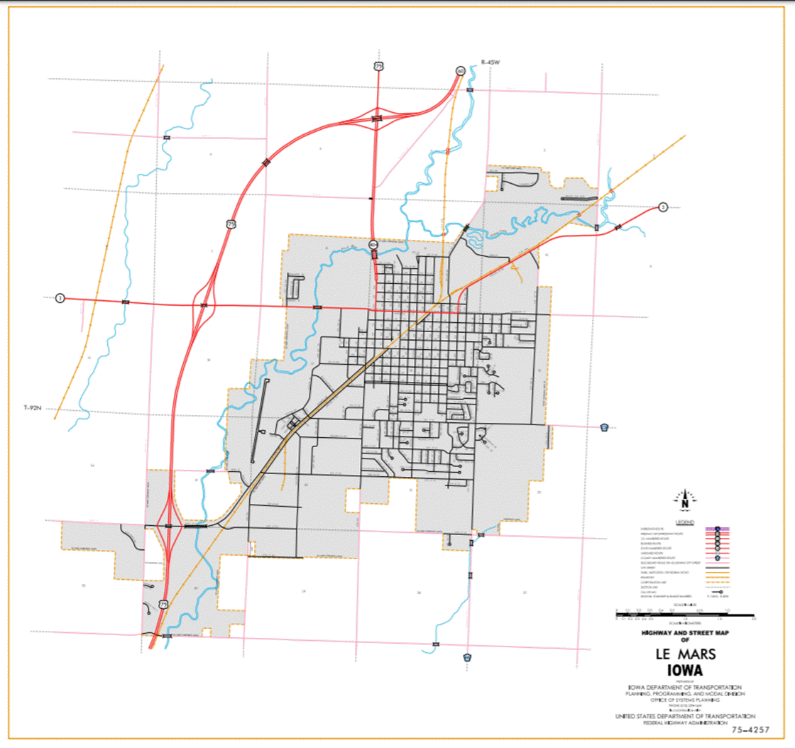
Le Mars:
Beginning at the south
corporation then northeast and north to the north corporation line.
Beginning again at north
corporation line of Le Mars; thence north and northeasterly through Sections 19, 18, 7, 6 and 5-T92N-R45W to the junction of Iowa 60 (approximately
1480 feet south of the NE Corner Section 5-T92N-R45W); thence northerly
following substantially the section line of Section 4-T92N-R45W and Sections 33, 28, 21, 16, 9 and 4‑T93N‑R45W
to the Plymouth‑Sioux County line at a point near the NW Corner Section 4‑T93N‑R45W,
Plymouth County (SW Corner Section 33‑T94N‑R45W, Sioux County).
OFFICIAL
DESCRIPTION CHANGE
OFFICE: Transportation Data
EFFECTIVE
DATE: December
2006
ENTERED
BY: Darlene Bovee
ENTERED
DATE: 09-05-2007
New
Description ‑ US 75 and its extensions in
Beginning
on the Plymouth‑Woodbury County line connecting with
Beginning
at the north corporation Line connecting with Lewis Boulevard; thence
northeasterly through Sections 31, 30 29, 20, 17 and 8‑T90N‑R46W to
the south corporation line of Hinton, connecting with Floyd Avenue
(approximately 1378 feet north and 184 feet west of the SE Corner of said
Section 8-T90N-R46W).
Hinton:
Beginning
at the south corporation line connecting with Floyd Avenue; thence
northeasterly to the north corporation line (approximately 1320 feet south and
280 feet east of the NW Corner Section 9-T90N-R46W).
Beginning
again on the north corporation line of Hinton connecting with Floyd Avenue;
thence in a northeasterly direction through Sections 9 and 4‑T90N‑R46W
and Sections 33, 28, 27, 22, 15, 10 and 11‑T91N‑R46W to the south
corporation line of Merrill, connecting with First Street (approximately 1290
feet south and 1390 feet east of the NW Corner Section 11-T91N-R46W).
Merrill:
Beginning
at the south corporation line connecting with First Street; thence
northeasterly to the east corporation line (approximately 850 feet north of the
S ¼ Corner Section 2-T91N-R46W).
Beginning
again on the east corporation line of Merrill connecting with First Street;
thence in a northeasterly direction through Sections 2 and 1‑T91N‑R46W,
Section 36‑T92N‑R46W and Sections 31, 30, 19, 18, 7, 6 and
5-T92N-R45W to the junction of Iowa 60 (approximately 1480 feet south of the NE
Corner Section 5-T92N-R45W); thence northerly following substantially the
section line of Section 4-T92N-R45W and
Sections 33, 28, 21, 16, 9 and 4‑T93N‑R45W to the Plymouth‑Sioux
County line at a point near the NW Corner Section 4‑T93N‑R45W,
Plymouth County (SW Corner Section 33‑T94N‑R45W, Sioux County).
OFFICIAL
DESCRIPTION CHANGE
COUNTY:
ROUTE: US 75
STAFF
ACTION NUMBER: S-87-1520
APPROVAL
DATE: 5-13-87
New
Description ‑ US 75 and its extensions in
Beginning
on the Plymouth‑Woodbury County line (north corporation line of Sioux
City) connecting with Lewis Blvd. at a point near the SW Corner Section 31‑T90N‑R46W,
Plymouth County (NE Corner Section 1‑T89N‑R47W, Woodbury County);
thence in a general northeasterly direction along the west side of the Illinois
Central Railroad and substantially parallel thereto through Sections 31, 30,
29, 20, 17 and 8‑T90N‑R46W to the south corporation line of Hinton,
connecting with
Hinton:
Beginning
on
Beginning
again on the north corporation line of Hinton connecting with
Merrill:
Beginning
on
Beginning
again on the east corporation line of Merrill connecting with 1st Street on the
west side of the Illinois Central Railroad; thence in a generally northeasterly
direction along the west side of said railroad and substantially parallel
thereto through Sections 2 and 1‑T91N‑R46W, Section 36‑T92N‑R46W
and Sections 31, 30, 19 and 20‑T92N‑R45W to the south corporation
line of Le Mars, connecting with
Le
Mars:
Beginning
on
Beginning
again on the north corporation line of Le Mars connecting with 5th Avenue;
thence north following substantially the section line of Sections 9 and 4‑T92N‑R45W
to a point (junction Iowa 60) approximately 200 feet north of the SW Corner
Section 4‑T92N‑R45W; thence north following substantially the
section line of Section 4‑T92N‑R45W and Sections 33, 28, 21, 16, 9
and 4‑T93N‑R45W to the Plymouth‑Sioux County line at a point
near the NW Corner Section 4‑T93N‑R45W,
COMMISSION
ORDER
DIVISION: Planning & Research
COMMISSION
ORDER NUMBER:
PR-79-272
SUBMITTED
BY: C.I. MacGillivray
MEETING
DATE:
11-2-79
TITLE:
DISCUSSION/BACKGROUND:
Due
to a review of our Primary Road System Records US 75 in
US
75 begins on the Plymouth‑Woodbury County line near the NE Corner of
Sioux City and travels generally northeasterly and northerly via Hinton,
Merrill and Le Mars, to the Plymouth‑Sioux County line approximately 8
miles north of Le Mars.
PROPOSAL/ACTION
RECOMMENDATION:
Locate
US 75 and its extensions in
Beginning
on the Plymouth‑Woodbury County line (north corporation line of the City
of Sioux City) connecting with an unnamed street at a point near the SW Corner
Section 31-T90N-R46W, Plymouth County (NE Corner Section 1‑T89N‑R47W,
Woodbury County); thence in a general northeasterly direction along the west
side of the Illinois Central Railroad and substantially parallel thereto
through Sections 31, 30, 29, 20, 17 and 8‑T90N-R46W to the south
corporation line of the City of
Hinton:
Beginning
on the south corporation line connecting with an unnamed street; thence in a
northeasterly direction to the north corporation line connecting with an
unnamed street.
Beginning
again on the north corporation line of the City of Hinton connecting with an
unnamed street on the west side of the Illinois Central Railroad; thence in a
northeasterly direction along the west side of said railroad and substantially
parallel thereto through Sections 9 and 4‑T90N‑R46W and Sections
33, 28, 27, 22, 15, 10 and 11‑T91N‑R46W to the south corporation
line of the City of
Merrill:
Beginning
on the south corporation line connecting with an unnamed street; thence in a northeasterly
direction to the north corporation line connecting with an unnamed street.
Beginning
again on the north corporation line of the City of Merrill connecting with an
unnamed street on the west side of the Illinois Central Railroad; thence in a generally
northeasterly direction along the west side of said railroad and substantially
parallel thereto through Sections 2 and 1‑T91N‑R46W, Section
36-T92N‑R46W and Sections 31, 30, 19 and 20‑T92N‑R45W to the
south corporation line of the City of
Le
Mars:
Beginning
on the south corporation line connecting with an unnamed street; thence northeasterly
and northerly to the north corporation line connecting with unnamed street.
Beginning
again on the north corporation line of the City of
NOW,
THEREFORE: Be it resolved that the Iowa
Department of Transportation approve the location of US 75 in
NOTE: To become effective upon the adoption of this
resolution.
REVISED: 5-13-87
OFFICIAL
DESCRIPTION CHANGE
COUNTY:
ROUTE: US 75
APPROVAL
DATE: 2-5-58
Beginning
on the Plymouth‑Woodbury County line (NE Corner of the corporate limits
of the City of Sioux City) connecting with an unnamed street at a point near
the SW Corner Section 31-T90N-R46W, Plymouth County, (NE Corner Section 1-T89N‑R47W,
Woodbury County); thence in a northeasterly direction along the west side of
the Illinois Central Railroad and substantially parallel thereto through
Section 31, 30, 29, 20, 17 and 8‑T90N‑R46W to the south corporation
line of the Town of Hinton, connecting with Floyd Avenue.
Beginning
again on the north corporation line of the Town of Hinton, connecting with
Floyd Avenue; thence in a northeasterly direction along the west side of the
Illinois Central Railroad and substantially parallel thereto through Section 8
and 4‑T90N-R46W to Wren Junction in the NW ¼ Section 4-T90N-R46W; thence
in a northeasterly direction along the west side of the Chicago and
Northwestern Railway and substantially parallel thereto, through Section 4‑T90N‑R46W
and Section 33, 28, 27, 22, 15, 10 and 11-T91N‑R46W to the south
corporation line of the Town of Merrill, connecting with the extension of First
Street.
Beginning
again on the east corporation line of the Town of Merrill, connecting with the
extension of First Street; thence in a northeasterly direction along the west
side of the Illinois Central Railroad and substantially parallel thereto,
through Section 2 and 1‑T91N‑R46W, Section 36‑T92N‑R46W,
and Section 31, 30, 19 and 20‑T92N‑R45W to the south corporation
line of the City of Le Mars; connecting with Hawkeye Avenue W.
Beginning
again on the north corporation line of the City of
REVISED:
11-2-79
OFFICIAL
DESCRIPTION CHANGE
COUNTY:
CITY
OF: Hinton
ROUTE: US 75
APPROVAL
DATE: 2-5-36
Commencing
on Floyd Avenue at the south corporation line; thence northeasterly on Floyd
Avenue to the north corporation line.
OFFICIAL
DESCRIPTION CHANGE
COUNTY:
CITY
OF: Merrill
ROUTE: US 75
APPROVAL
DATE: 2-5-58
Commencing
on the extension of First Street at the south corporation line; thence
northeasterly on the extension of First Street, and on First Street along the
northwest side of the Illinois Central Railroad to the east corporation line.
REVISED: 11-2-79
OFFICIAL
DESCRIPTION CHANGE
COUNTY:
CITY
OF: Le Mars
ROUTE: US 75
APPROVAL
DATE: 2-5-36
Commencing
on Hawkeye Avenue W at the south corporation line; thence northeasterly on
Hawkeye Avenue W to Fifth Avenue W; thence northerly on Fifth Avenue W to the
north corporation line.
REVISED: 11-2-79