OFFICIAL
DESCRIPTION CHANGE
OFFICE:
Research and Analytics
EFFECTIVE
DATE: 10-22-14
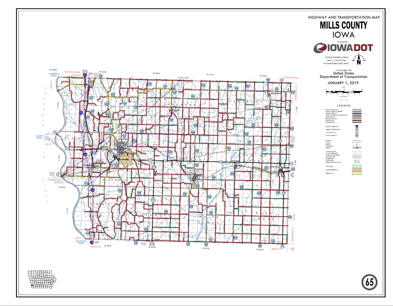
COUNTY:
Mills
ROUTE:
US 34
ENTERED
BY: Paul Mauer
ENTERED
DATE: 12-13-19
New
Description ‑ US 34 and its extension in
Beginning at point at the west
section line of Section 2-T72N-R44W (Iowa-Nebraska State line); thence
southeasterly through Sections 2, 11 and 12-T72N-R44W; thence east through
Section 13-T72N-R44W and Section 18-T72N-R43W to a point approximately 900 feet
west of NW Corner of Section 17-T72N-R43W (Junction Interstate 29 and west
junction US 275); thence northeasterly through Sections 8, 9 and 10-T72N-R43W;
thence southeasterly through Sections 15 and 14-T72N-R43W to the west
corporation line of Glenwood.
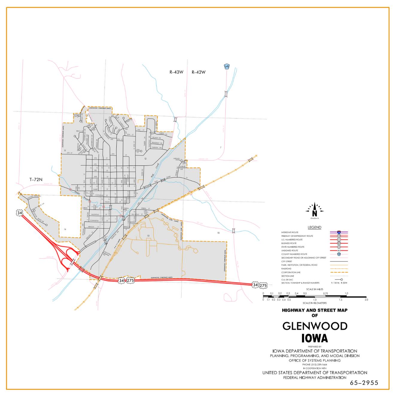
Glenwood:
Beginning at the west corporation
line; thence southeast to the east corporation line.
Beginning
again at the east corporation line of Glenwood; thence east following
substantially the north section line of Section 24-T72N-R43W and Sections 19, 20, 21 (east junction US
275), 22 and 23‑T72N‑R42W to a point approximately 475 feet east of
the S ¼ Corner Section 14‑T72N‑R42W; thence easterly through
Sections 14 and 13‑T72N‑R42W to a point approximately 100 feet west
of the N ¼ Corner NE ¼ Section 24‑T72N‑R42W; thence easterly
following substantially the section line of Section 24‑T72N‑R42W,
Sections 19, 20, 21, 22, 23, and 24‑T72N‑R41W and Sections 19, 20,
21, 22, 23 (junction US 59) and 24‑T72N‑R40W to the Mills‑Montgomery
County line at a point approximately 110 feet south of the NE Corner Section 24‑T72N‑R40W,
Mills County (NW Corner Section 19‑T72N‑R39W, Montgomery County).
OFFICIAL
DESCRIPTION CHANGE
COUNTY: Mills
ROUTE: US 34
STAFF
ACTION NUMBER: S-87-1530
APPROVAL
DATE:
5-13-87
New
Description ‑ US 34 and its extension in
Beginning
at a point in the SE ¼ of Section 26‑T72N‑R44W (Iowa‑Nebraska
State line); thence northeasterly and easterly through the SE ¼ said Section 26
and southeasterly through the SW ¼ Section 25‑T72N‑R44W to a point
approximately 830 feet east of the SW Corner Section 25‑T72N‑R44W;
thence east following substantially the section line of Section 36‑T72N‑R44W
and Sections 31 and 32‑T72N‑R43W to a point approximately 1,155
feet west of the SE Corner Section 29‑T72N‑R43W (south junction
Interstate 29); thence in a northwesterly direction through Sections 29, 20,
and 17‑T72N‑R43W to a point approximately 825 feet east of the NW
Corner Section 17‑T72N‑R43W (north junction Interstate 29) (with a
spur 676 feet west to the west line of the ramps of Interstate 29); thence in
an easterly and northeasterly direction through the south part of Sections 8, 9
and 10‑T72N‑R43W and in a southeasterly direction through Sections
10, 15 and 14‑T72N‑R43W (east junction US 275) to the west
corporation line of Glenwood, connecting with an unnamed street.
Glenwood:
Beginning on the west corporation line connecting with
an unnamed street; thence southeasterly to the east corporation line connecting
with an unnamed street.
Beginning
again on the east corporation line of Glenwood connecting with an unnamed
street; thence southeasterly through Section 13‑T72N‑R43W and
easterly through Sections 24 and 13‑T72N‑R43W and Section 18‑T72N‑R42W
to a point approximately 1,000 feet west of the SE Corner Section 18‑T72N‑R42W;
thence easterly following substantially the section line of Sections 19, 20, 21
(east junction US 275), 22 and 23‑T72N‑R42W to a point
approximately 475 feet east of the S ¼ Corner Section 14‑T72N‑R42W;
thence easterly through Sections 14 and 13‑T72N‑R42W to a point
approximately 100 feet west of the N ¼
OFFICIAL
DESCRIPTION CHANGE
COUNTY: Mills
ROUTE: US 34
STAFF
ACTION NUMBER:
APPROVAL
DATE:
Locate
US 34 in
Beginning
at a point in the SE ¼ of Section 26-T72N‑R44W (Iowa‑Nebraska State
line); thence northeasterly and easterly through the SE ¼ said Section 26 and
southeasterly through the SW ¼ Section 25‑T72N‑R44W to a point
approximately 830 feet east of the SW Corner Section 25-T72N-R44W; thence east
following substantially the section line of Section 36‑R72N‑R44W
and Sections 31 and 32‑T72N‑R43W to a point approximately 1155 feet
west of the SE Corner Section 29‑T72N‑R43W (south junction
Interstate 29); thence in a northwesterly direction through Sections 29, 20,
and 17-T72N‑R43W to a point approximately 825 feet east of the NW Corner
Section 17‑T72N‑R43W (north junction Interstate 29) (with a spur
676 feet west to the west line of the ramps of Interstate 29); thence in an
easterly and northeasterly direction through the south part of Sections 8, 9
and 10 T72N-R43W and in a southeasterly direction through Sections 10, 15 and
14 T72N-43W to the west corporation line of the City of Glenwood, connecting
with an unnamed street.
Glenwood:
Beginning
on the west corporation line connecting with an unnamed street; thence
southeasterly to the east corporation line connecting with an unnamed street.
Beginning
again on the east corporation line of the city of Glenwood connecting with an
unnamed street; thence southeasterly though Section 12 T72N-R43W and easterly
through Sections 13, 24 and 13 T72N-R43W and Section 18-T72N-R42W; thence
easterly following substantially the section line of Sections 19, 20, 21 (east
junction US 275), 22 and 23 T72N-R42W to a point approximately 475 feet east of
the S ¼ Corner Section 14 T72N-R42W; thence easterly though Sections 14 and 13
T72N-42W to a point approximately 100 feet west of the N ¼ Corner NE ¼ Section
24-T72N-R42W, Sections 19, 20, 21, 22, 23, and 24 T72N-R41W and Sections 19,
20, 21, 22, 23 (junction US 59) and 24 T72N-R40W to the Mills Montgomery County
line at a point approximately 110 feet south of the NE Corner Section 24
T72N-R40W, Mills county (NW Corner Section 19 T72N-R39W, Montgomery County).
REVISED:
5-13-87
COMMISSION
ORDER
DIVISION: Planning & Research
COMMISSION
ORDER NUMBER:
PR-79-272
SUBMITTED
BY: C.I.
MacGillivray
MEETING
DATE:
11-2-78
TITLE:
DISCUSSION/BACKGROUND:
Due
to a review of our Primary Road System Records, US 34 in Mills County should be
deleted and the new description added should be officially included into the
Primary System.
PROPOSAL/ACTION
RECOMMENDATION:
It
is recommended that the old description of US 34 in Mills County be deleted and
the new description, as referred in the attached detailed description, be
included in the Primary Road System effective upon the adoption of this
resolution.
Locate
US 34 in
Beginning
at a point in the SE ¼ of Section 26‑T72N‑R44W (Iowa‑Nebraska
State line); thence northeasterly and easterly across the SE Corner said
Section 26 and southeasterly across the SW Corner Section 25‑T72N‑R44W
to a point approximately 830 feet east of the SW Corner Section 25-T72N-R44W;
thence east following substantially the section line of Section 36‑R72N‑R44W
and Sections 31 and 32‑T72N‑R43W to a point approximately 1155 feet
west of the SE Corner Section 29‑T72N‑R43W (south junction
Interstate 29); thence in a northwesterly direction through Sections 29, 20,
and 17-T72N‑R43W to a point approximately 825 feet east of the NW Corner
Section 17‑T72N‑R43W (north junction Interstate 29) (with a spur
676 feet west to the west line of the ramps of Interstate 29); thence in an
easterly and northeasterly direction through the south part of Sections 8, 9,
and 10‑T72N‑R43W to a point approximately 990 feet south of the W ¼
Corner SE ¼ Section 10‑T72N‑R43W; thence in a southeasterly
direction through the S ¼ of Section 10 and the NE ¼ Section 15‑T72N‑R43W;
continuing southeasterly through Section 14‑T72N‑R43W to a point
near the W ¼ Corner SE ¼ Section 14‑T72N‑R43W (junction US 275);
thence continuing southeasterly through Sections 14 and 13‑T72N‑R43W
and easterly through Sections 13, 24, 13‑T72N‑R43W and Section 18‑T72N‑R42W
to a point approximately 1,000 feet west of the SE Corner Section 18‑T72N‑R42W;
thence easterly following substantially the section line of Sections 19, 20.
21, 22, and 23-T72N-R42W to a point approximately 475 feet east of the S ¼
Corner Section 14-T72N-R42W; thence easterly through Sections 14 and 13‑T72N‑R42W
to a point approximately 100 feet west of the N ¼ Corner NE ¼ Section 24‑T72N‑R42W;
thence easterly following substantially the section line of Section 24-T72N-R42W,
Sections 19, 20, 21, 22, 23, and 24‑T72N‑R41W and Sections 19, 20,
21, 22, 23 (junction US 59) and 24‑T72N‑R40W to the Mills‑Montgomery
County line at a point approximately 110 feet south of the NE Corner Section 24‑T72N‑R40W,
OFFICIAL
DESCRIPTION CHANGE
COUNTY: Mills
ROUTE: US 34
APPROVAL
DATE:
2-6-74
Beginning
at the east end of the Missouri River Bridge (approximately 750 feet west and
130 feet north of the SE Corner Section 26‑T72N‑R44W; thence northeasterly
and easterly across the SE Corner Section 26 and southeasterly across the SW
Corner Section 25 to a point approximately 830 feet east of the SW Corner
Section 25‑T72N‑R44W; thence east following substantially the
section line along the south line of Sections 25‑R72N‑R44W and
Sections 30 and 29‑T72N‑R43W to a point approximately 1155 feet
west of the SE Corner Section 29‑T72N‑43W (south junction
Interstate 29) (with a spur 416 feet east to the east line of the ramps of
Interstate 29); thence in a northwesterly direction through Sections 29, 20,
and 17-T72N‑R43W to a point approximately 825 feet east of the NW Corner
Section 17‑T72N‑R43W (north junction Interstate 29) (with a spur
676 feet west to the west line of the ramps of Interstate 29); thence in an
easterly and northeasterly direction through the south part of Sections 8, 9,
and 10‑T72N‑R43W to a point approximately 990 feet south of the W ¼
Corner SE ¼ Section 10‑T72N‑R43W; thence in a southeasterly
direction through the S ¼ Corner of Section 10 and the NE ¼ Corner 15‑T72N‑R43W
continuing southeasterly through Section 14‑T72N‑R43W to a point
near the W ¼ Corner SE ¼ Section 14‑T72N‑R43W (US 275); thence
continuing southeasterly to a point approximately 660 feet west of the SE
Corner Section 14‑T72N‑R43W; thence easterly following substantially
the north line of Sections 23 and 24‑T72N‑R43W and the north line
of Sections 19, 20, 21, 22, 23 and 24‑T72N‑R42W, continuing in an
easterly direction along the north line of Sections 19, 20, 21, 22, 23 and 24‑T72N‑R41W,
continuing in an easterly direction along the north line of Sections 19, 20,
21, 22, 23 and 24‑T72N‑R40W to Mills‑Montgomery County line
at a point approximately 110 feet south of the NE Corner Section 24‑T72N‑R40W,
Mills County (NW Corner Section 19-T72N-R39W, Montgomery County).
REVISED:
1978
OFFICIAL
DESCRIPTION CHANGE
COUNTY: Mills
CITY
OF: Emerson
ROUTE: US 34
APPROVAL
DATE: 2-5-36
Commencing
on Morton Avenue at the west corporation line; thence easterly on Morton
Avenue to the east corporation line.