OFFICIAL
DESCRIPTION CHANGE
OFFICE:
Transportation Data
EFFECTIVE DATE: 07-01-2003
ENTERED
BY: Stefani Wonders
ENTERED
DATE: 08-22-2006
DISCUSSION/BACKGROUND:
Senate File 451 transferred US 275 in its entirety,
in
OFFICIAL
DESCRIPTION CHANGE
COUNTY: Mills
ROUTE:
US 275
STAFF
ACTION NUMBER:
S-87-1530
APPROVAL
DATE: 5-13-87
New
Description: US 275 and its extensions in
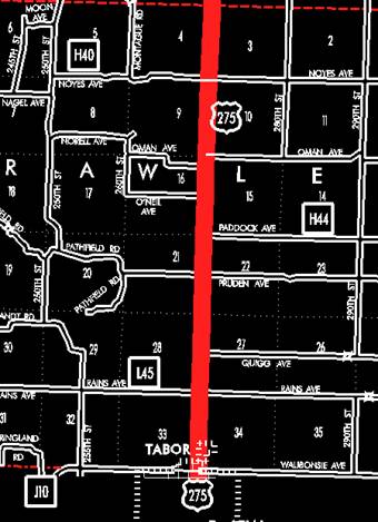
Tabor:
Beginning
on
Beginning
on the north corporation line of Tabor connecting with Main Street; thence
north following substantially the section line of Sections 34, 27, 22, 15, 10,
and 3‑T71N‑R42W and Sections 34, 27, and 22‑T72N‑R42W
(east junction US 34) to a point near the NE Corner Section 21‑T72N‑R42W;
thence west following substantially the section line of Sections 21, 20, and 19‑T72N‑R42W
to a point approximately 1,000 feet west of the NE Corner Section 19‑T72N‑R42W;
thence westerly through the south part of Section 18‑T72N‑R42W and
Section 13‑T72N‑R43W to a point approximately 1,350 feet east of
the SW Corner said Section 13; thence southwesterly and northwesterly through
Section 24‑T72N‑R43W to a point approximately 600 feet east of the
NW Corner said Section 24; thence northwesterly through Section 13‑T72N‑R43W
to the east corporation line of Glenwood, connecting with an unnamed street.
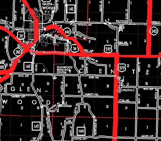
Glenwood:
Beginning
on an unnamed street at the east corporation line; thence northwest on unnamed
street to the west corporation line.
Beginning
again on the west corporation line of Glenwood connecting with an unnamed
street; thence northwesterly through Section 14‑T72N‑R43W to a
point approximately 495 feet east of the W ¼ Corner SE ¼ Section 14‑T72N‑R43W
(west junction US 34); thence in a northeasterly direction through Section 14‑T72N‑R43W
to the south corporation line of Glenwood connecting with Locust Street.
Glenwood:
Beginning
on
Beginning
again on the north corporation line of Glenwood connecting with Locust Street;
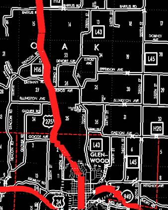
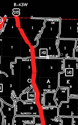
thence in a northwesterly direction through Sections 11 and 2‑T72N‑R43W
and Sections 35, 26, 27, 22, 15, 10, 3, and 4‑T73N‑R43W to the
Mills‑Pottawattamie County line at a point approximately 1,320 feet west
of the NE Corner Section 4‑T73N‑R43W, Mills County (SE Corner
Section 33‑T74N‑R43W, Pottawattamie County).
OFFICIAL
DESCRIPTION CHANGE
COUNTY:
Mills
ROUTE:
US 275
APPROVAL
DATE:
Locate
US 275 and its extensions in
Tabor:
Beginning
at the Mills‑Fremont County line on an unnamed street; thence northerly
to the north corporation line connecting with an unnamed street.
Beginning
on the north corporation line of the City of Tabor connecting with an unnamed
street; thence north following substantially the section line of Sections 34,
27, 22, 15, 10, and 3‑T71N‑R42W and Sections 34, 27, and 22‑T72N‑R42W
(east junction US 34) to a point near the NE Corner Section 21‑T72N‑R42W;
thence west following substantially the section line of Sections 21, 20, and 19-T72N‑R42W
to a point approximately 1,000 feet west of the NE Corner Section 19‑T72N‑R42W;
thence westerly through the south part of Section 18‑T72N‑R42W and
Section 13‑T72N‑R43W to a point approximately 1350 feet east of the
SW Corner said Section 13; thence southwesterly and northwesterly through
Section 24‑T72N‑R43W to a point approximately 600 feet east of the
NW Corner said Section 24; thence northwesterly through Section 13 T72N-R43W to
the east corporation line of the City of Glenwood, connecting with an unnamed
street.
Glenwood:
Beginning on the east corporation
line connecting with an unnamed street; thence northwesterly to the west
corporation line connecting with an unnamed street.
Beginning
again on the west corporation line of the City of Glenwood connecting with an
unnamed street; thence northwesterly through Section 14, T72-R43N to a point
approximately 495 feet east of the W ¼ Corner Section 14‑T72N‑R43W
(west junction US 34) thence in a northeasterly direction through Section 14‑T72N‑R43W
to the south corporation line of the City of Glenwood connecting with an
unnamed street.
Glenwood:
Beginning at the south corporation
line connecting with an unnamed street; thence northeasterly, northerly, and
northwesterly to the north corporation line connecting with an unnamed street.
Beginning
again on the north corporation line of the City of Glenwood connecting with an
unnamed street; thence, in a northwesterly direction through Sections 11 and 2‑T72N‑R43W
and Sections 35, 26, 27, 22, 15, 10, 3, and 4‑T73N‑R43W to the
Mills‑Pottawattamie County line at a point approximately 1320 feet west
of the NE Corner Section 4‑T73N‑R43W, Mills County (SE Corner
Section 33‑T74N‑R43W, Pottawattamie County).
REVISED:
5-13-87
COMMISSION
ORDER
DIVISION:
Planning & Research
COMMISSION
ORDER NUMBER:
PR-79-272
SUBMITTED
BY: C.I. MacGillivray
MEETING
DATE: 11-2-78
DISCUSSION/BACKGROUND:
Due to a review of our Primary Road System records,
US 275 begins in Tabor at the
Mills‑Fremont County line and travels in a northerly and northwesterly
direction to the
PROPOSAL/ACTION RECOMMENDATION:
Locate
US 275 and its extensions in
Tabor:
Beginning
at the Mills‑Fremont County line on an unnamed street; thence northerly
to the north corporation line connecting with an unnamed street.
NOTE:
Beginning
on the north corporation line of the City of Tabor connecting with an unnamed
street; thence north following substantially the section line of Sections 34,
27, 22, 15, 10, and 3‑T71N‑R42W and Sections 34, 27, and 22‑T72N‑R42W
(east junction US 34) to a point near the NE Corner Section 21‑T72N‑R42W;
thence west following substantially the section line of Sections 21, 20, and
19-T72N‑R42W to a point approximately 1,000 feet west of the NE Corner
Section 19‑T72N‑R42W; thence westerly through the south part of
Section 18‑T72N‑R42W and Section 13‑T72N‑R43W to a
point approximately 1350 feet east of the SW Corner said Section 13; thence
southwesterly and northwesterly through Section 24‑T72N‑R43W to a
point approximately 600 feet east of the NW Corner said Section 24; thence
northwesterly through Sections 13 and 14‑T72N‑R43W to a point
approximately 825 feet west of the SE Corner Section 14‑T72N‑R43W;
thence in a northwesterly direction to a point approximately 495 feet east of
the W ¼ Corner SE ¼ Section 14‑T72N‑R43W (west junction US 34);
thence in a northeasterly direction through Section 14‑T72N‑R43W to
the south corporation line of the City of Glenwood connecting with an unnamed street.
Glenwood:
Beginning at the south corporation
line connecting with an unnamed street; thence northeasterly, northerly, and
northwesterly to the north corporation line connecting with an unnamed street.
Beginning
again on the north corporation line of the City of Glenwood connecting with an
unnamed street; thence in a northwesterly direction through Sections 11 and 2‑T72N‑R43W
and Sections 35, 26, 27, 22, 15, 10, 3, and 4‑T73N‑R43W to the
Mills‑Pottawattamie County line at a point approximately 1320 feet west
of the NE Corner Section 4‑T73N‑R43W, Mills County (SE Corner
Section 33‑T74N‑R43W, Pottawattamie County).
NOW,
THEREFORE: Be it resolved that the Iowa Department of Transportation approve
the location of US 275,
NOTE:
To become effective upon the adoption of this resolution.
OFFICIAL
DESCRIPTION CHANGE
COUNTY: Mills
ROUTE:
US 275
APPROVAL
DATE: 2-6-74
Tabor:
Beginning
on the north corporation line of the Town of Tabor (Mills‑Fremont County
line) connecting with Main Street; thence north following substantially the
section line to a point near the NE Corner of Section 21‑T72N‑R42W;
thence west following substantially the section line along the south line of
Sections 16, 17, and 18‑T72N‑R42W; thence westerly following
substantially along the south line of Sections 13 and 14‑T72N‑R43W
to a point approximately 825 feet west of the SE Corner Section 14‑T72N‑R43W;
thence in a northwesterly direction to a point approximately 495 feet east of
the W ¼ Corner SE ¼ Section 14‑T72N‑R43W; thence in a northeasterly
direction to the south corporation line of the Town of
Glenwood:
Commencing
on
Beginning
again on the north corporation line of the Town of Glenwood connecting with
Locust Street; thence in a northwesterly direction through Section 11 and 2‑T72N‑R43W
and Sections 35, 26, 27, 22, 15, 10, 3 and 4‑T73N‑R43W to the Mills‑Pottawattamie
County line at a point approximately ¼ mile west of the NE Corner Section 4‑T73N‑R43W,
Mills County (SE Corner Section 33‑T74N‑R43W, Pottawattamie
County).