OFFICIAL
DESCRIPTION CHANGE
OFFICE:
Research and Analytics
EFFECTIVE
DATE: 1-13-2015
COUNTY:
Linn
ROUTE:
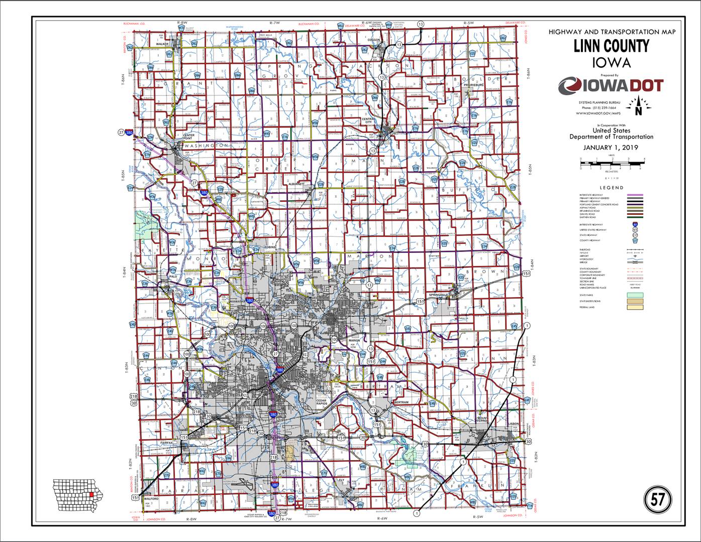
Interstate 380
ENTERED
BY: Paul Mauer
ENTERED
DATE: 11-22-2019
DISCUSSION/BACKGROUND:
Due
to a review of our Primary System records, the primary route description for
Interstate 380 in
PROPOSAL/ACTION
RECOMMENDATION:
New
Description - Interstate 380 and its extensions in
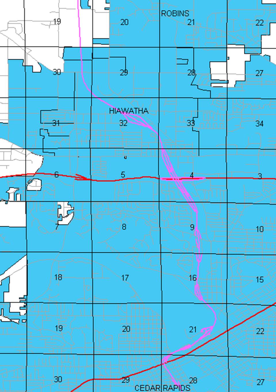
Beginning on the Linn-Johnson County line
approximately 2368 feet east of the SW Corner Section 33-T82N-R07W, Linn County
(NW Corner Section 4-T81N-R07W, Johnson County); thence northerly to the south
corporation line of Cedar Rapids (approximately 1286 feet north and 2274 feet
east of the SW Corner of said Section 33).
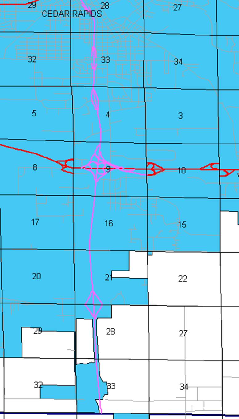
Beginning at the south corporation line; thence
northerly through Sections 33, 28, 21, 16, 9 (junction US 30/US 151 and US 218),
and 4-T82-N-R07W and Sections 33 and 28-T83N-R07W to approximately 2303 feet
east and 1089 feet north of the SW Corner of said Section 28 (junction Iowa
922); thence northwesterly, northeasterly, and northwesterly through Sections
28, 21, and 16-T83N-R07W to approximately 3137 feet west and 1600 feet north of
the SE Corner of said Section 16; thence northerly through Sections 16 and
9-T83N-R07W to approximately 3917 feet east and 1484 feet south of the NW
Corner of said Section 9; thence northwesterly through Sections 9 and 4-T83N-R07W
(junction Iowa 100) to the north corporation/south corporation of Hiawatha
(approximately 676 feet east and 809 feet south of the NW Corner of said
Section 4).
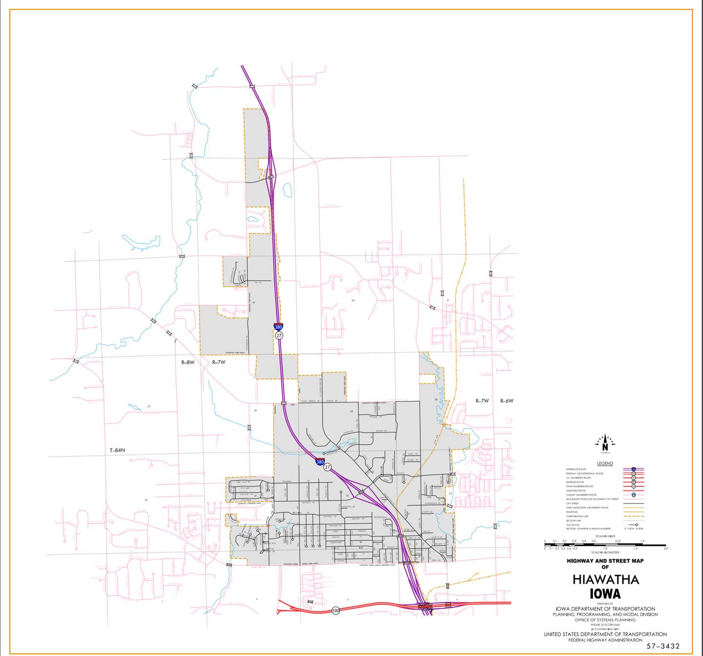
Hiawatha:
Beginning at the south corporation line; thence
northwesterly through Section 4-T83N-R07W and Sections 33, 32, 29, and
30-T84N-R07W to the north corporation line/south corporation line of Cedar
Rapids (approximately 1021 feet west of the E ¼ Corner of said Section 30).
Beginning at the south corporation line/north
corporation line of Hiawatha; thence northwesterly to the north corporation
line/south corporation line of Hiawatha (approximately 1316 feet north and 1132
feet west of the E ¼ Corner Section 30-T84N-R07W).
Hiawatha:
Beginning at the south corporation line/north
corporation line of Cedar Rapids; thence northerly through Sections 19 and
18-T84N-R07W; thence northerly and northwesterly through Section 7-T84N-R07W to
the north corporation line.
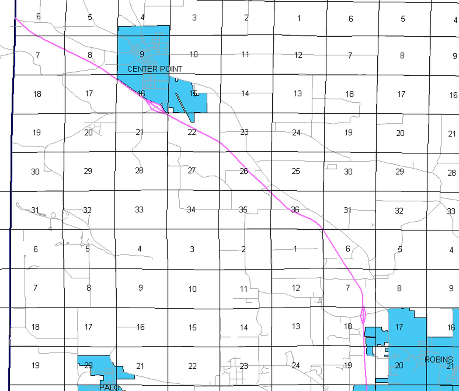
Beginning again on the north corporation line of
Hiawatha; thence northwesterly
through Sections 7, and 6-T84N-R07W and Sections 36, 35, 26, 23, 22, 21, 16,
17, 8, 7, and 6-T85N-R08W to the Linn-Benton County line at a point near the W
¼ Corner Section 6-T85N-R08W, Linn County (E ¼ Corner Section 1-T85N-R09W,
Benton County).
OFFICIAL
DESCRIPTION CHANGE
OFFICE: Transportation Data
ENTERED
BY: Stefani Wonders
ENTERED
DATE: 09-18-2006
DISCUSSION/BACKGROUND:
Due
to a review of our Primary System records, the primary route description for
Interstate 380 in
PROPOSAL/ACTION
RECOMMENDATION:
New
Description - Interstate 380 and its extensions in
Beginning on the Linn-Johnson County line
approximately 2368 feet east of the SW Corner Section 33-T82N-R7W, Linn County
(NW Corner Section 4-T81N-R7W, Johnson County); thence northerly to the south
corporation line of Cedar Rapids connecting with an unnamed street (approximately
1286 feet north and 2274 feet east of the SW Corner of said Section 33).
Beginning on an unnamed street at the south
corporation line; thence northerly through Sections 33, 28, 21, 16, 9, and
4-T82-N-R7W and Sections 33 and 28-T83N-R7W to approximately 2303 feet east and
1089 feet north of the SW Corner of said Section 28; thence northwesterly,
northeasterly, and northwesterly through Sections 28, 21, and 16-T83N-R7W to
approximately 3137 feet west and 1600 feet north of the SE Corner of said
Section 16; thence northerly through Sections 16 and 9-T83N-R7W to
approximately 3917 feet east and 1484 feet south of the NW Corner of said
Section 9; thence northwesterly through Sections 9 and 4-T83N-R7W to the north
corporation/south corporation of Hiawatha connecting with an unnamed street
(approximately 676 feet east and 809 feet south of the NW Corner of said
Section 4).
Hiawatha:
Beginning on an unnamed street at the south
corporation line; thence northwesterly on said unnamed street through Section
4-T83N-R7W and Sections 33, 32, 29, and 30-T84N-R7W to the north corporation
line/south corporation line of Cedar Rapids connecting with an unnamed street
(approximately 1021 feet west of the E ¼ Corner of said Section 30).
Beginning on an unnamed street at the south
corporation line/north corporation line of Hiawatha; thence northwesterly on
said unnamed street to the north corporation line/south corporation line of
Hiawatha connecting with an unnamed street (approximately 1316 feet north and
1132 feet west of the E ¼ Corner Section 30-T84N-R7W).
Hiawatha:
Beginning on an unnamed street at the south
corporation line/north corporation line of
Beginning again on the north corporation line of
Hiawatha connecting with an unnamed street; thence northerly and
northwesterly through Sections 19, 18, 7, and 6-T84N-R7W and Sections 36, 35,
26, 23, 22, 21, 16, 17, 8, 7, and 6-T85N-R8W to the Linn-Benton County line at
a point near the W ¼ Corner Section 6-T85N-R8W, Linn County (E ¼ Corner Section
1-T85N-R9W, Benton County).
STAFF
ACTION
OFFICE: Transportation Inventory
STAFF
ACTION NUMBER:
S-02-1137
SUBMITTED
BY: Peggi Knight
SUBMITTAL
DATE:
06-12-2002
DISCUSSION/BACKGROUND:
New
Description – Interstate 380 and its extensions in
Beginning
on the Johnson County Line near the S ¼ Corner Section 33-T82N-R7W; thence in a
northerly direction through Sections 33-T82N-R7W to south corporation line of
the City of Cedar Rapids, connecting with an unnamed street (approximately 1760
feet east and 1300 feet north of the SE Corner Section 33-T82N-R7W).
Beginning
on the south corporation line, connecting with an unnamed street (approximately
1760 feet east and 1300 feet north of the SE Corner Section 33-T82N-R7W);
thence in a northerly, northwesterly, and northerly direction on said unnamed
street to a point on Wilson Avenue Southwest approximately midway between
"L" Street Southwest and Third Street Southwest; thence northerly on
said unnamed street to a point approximately midway between "L"
Street Southwest and Third Street Southwest at Twelfth Avenue Southwest; thence
northwesterly on said unnamed street approximately midway between Third Street
Southwest and Fourth Street Southwest to First Avenue West; thence curving
northeasterly on said unnamed street across the Cedar River to a point near
Third Street Northeast and "A" Avenue Northeast; thence northeasterly
on said unnamed street to a point near Twelfth Street Northeast and
"D" Avenue Northeast extended westerly; thence northwesterly on said
unnamed street to a point near "H" Avenue Northeast and Tenth Street
Northeast; thence generally northerly on unnamed street to a point near
Coldstream Avenue; thence generally northerly on unnamed street to a point near
Glass Road; thence northerly and northwesterly on unnamed street to a point
near 42nd Street; thence northwesterly on unnamed street to Collins Avenue
Northeast (junction Iowa 100); thence northwesterly to Blairs Ferry Road (north
corporation line of Cedar Rapids) (south corporation line of Hiawatha).
Hiawatha:
Beginning
on an unnamed street at the south corporation line (Blairs Ferry Road); thence
northwesterly on said unnamed street to Boysen Road; thence continuing
northwesterly on said unnamed street to the north corporation line (south
corporation line of the City of Cedar Rapids), connecting with an unnamed
street (approximately 750 feet west of the E ¼ Corner Section 30-T84N-R7W).
Beginning
on the south corporation line (north corporation line of Hiawatha), connecting
with an unnamed street (approximately 750 feet west of the E ¼ Corner Section
30-T84N-R7W); thence northerly on said unnamed street approximately 1300 feet
to the north corporation line.
Beginning
again on the north corporation line of the City of Cedar Rapids, connecting
with an unnamed street; thence northerly and northwesterly through Sections 30,
19, 18, 7, and 6-T84N-R7W and Sections 36, 35, 26, 23, 22, 21, 16, 17, 8, 7, and
6-T85N-R8W to the Linn-Benton County line at a point near the W ¼ Corner
Section 6-T85N-R8W, Linn County (E ¼ Corner Section 1-T85N-R9W, Benton County).
PROPOSAL/ACTION
RECOMMENDATION:
It
is recommended that the old description of Interstate 380 and its extensions in
STAFF
ACTION
OFFICE: Transportation Inventory
STAFF
ACTION NUMBER:
S-85-413
SUBMITTED
BY: Patrick R. Cain
SUBMITTAL
DATE:
10-18-84
DISCUSSION/BACKGROUND:
Interstate
380 was opened to traffic to a junction with
Interstate
380 begins at the Linn‑Johnson County line approximately 2 miles south of
PROPOSAL/ACTION
RECOMMENDATION:
It
is recommended to approve revising the description of Interstate 380 in
New
Description – Interstate 380 and its extensions in
Beginning
at the Johnson County line near the S ¼ Corner Section 33‑T82N‑R7W;
thence in a northerly direction through Sections 33 and 28‑T82N‑R7W
to the south corporation line of the City of Cedar Rapids connecting with an
unnamed street.
Beginning
on an unnamed street at the south corporation line; thence in a northerly,
northwesterly, and northerly direction on said unnamed street to a point on
Wilson Avenue Southwest approximately midway between "L" Street
Southwest and Third Street Southwest; thence northerly on said unnamed street
to a point approximately midway between "L" Street Southwest and
Third Street Southwest at Twelfth Avenue Southwest; thence northwesterly on
said unnamed street approximately midway between Third Street Southwest and
Fourth Street Southwest to First Avenue West; thence curving northeasterly on
said unnamed street across the Cedar River to a point near Third Street
Northeast and "A" Avenue Northeast; thence northeasterly on said
unnamed street to a point near Twelfth Street Northeast and "D"
Avenue Northeast extended westerly; thence northwesterly on said unnamed street
to a point near "H" Avenue Northeast and Tenth Street Northeast;
thence generally northerly on unnamed street to a point near Coldstream Avenue;
thence generally northerly on unnamed street to a point near Glass Road; thence
northerly and northwesterly on unnamed street to a point near 42nd Street;
thence northwesterly on unnamed street to Collins Avenue Northeast (junction
Iowa 100); thence northwesterly to Blairs Ferry Road (north corporation line of
Cedar Rapids) (south corporation line of Hiawatha).
Hiawatha:
Beginning
on an unnamed street at the south corporation line (
Beginning
again on the north corporation line of Hiawatha connecting with an unnamed
street; thence northerly and northwesterly through Sections 30, 19, 18, 7 and 6‑T84N‑R7W
and Sections 36, 35, 26, 23, 22, 21, 16, 17, 8, 7 and 6‑T85N‑R8W to
the Linn‑Benton County line at a point near the W ¼ Corner Section 6‑T85N‑R8W
Linn County (E ¼ Corner Section 1‑T85N‑R9W, Benton County).
COMMISSION
ORDER
DIVISION: Planning & Research
COMMISSION
ORDER NUMBER:
PR-82-456
SUBMITTED
BY: Patrick R. Cain
MEETING
DATE:
1-5-82
DISCUSSION/BACKGROUND:
Interstate
380 begins on the Linn‑Johnson County line near the northwest corner of
the City of
Due
to the construction of an additional portion of Interstate 380 in the City of
PROPOSAL/ACTION
RECOMMENDATION:
It
is recommended the commission approve deleting the present description of
Interstate 380 in
Locate
Interstate 380 and its extension in
Beginning
at the Johnson county line near the S ¼ Corner Section 33‑T82N‑R7W;
thence in a northerly direction through Sections 33 and 28‑T82N‑R7W
to the south corporation line of the City of Cedar Rapids connecting with an
unnamed street.
Beginning
on an unnamed street at the south corporation line; thence in a northerly,
northwesterly, and northerly direction on said unnamed street to a point on
Wilson Avenue Southwest approximately midway between "L" Street
Southwest and Third Street Southwest; thence northerly on said unnamed street
to a point approximately midway between "L" Street Southwest and
Third Street Southwest at Twelfth Avenue Southwest; thence northwesterly on
said unnamed street approximately midway between Third Street Southwest and
Fourth Street Southwest to First Avenue West; thence curving northeasterly on
said unnamed street across the Cedar River to a point near Third Street
Northeast and "A" Avenue Northeast; thence northeasterly on said
unnamed street to a point near Twelfth Street Northeast and "D"
Avenue Northeast extended westerly; thence northwesterly on said unnamed street
to a point near "H" Avenue Northeast and Tenth Street Northeast;
thence generally northerly on unnamed street to a point near Coldstream Avenue.
REVISED:
10-18-84
COMMISSION
ORDER
DIVISION: Planning & Research
COMMISSION
ORDER NUMBER:
PR-79-272
SUBMITTED
BY: C.I. MacGillivray
MEETING
DATE:
11-2-78
DISCUSSION/BACKGROUND:
Due
to a review of our Primary Road System records Interstate 380 in
PROPOSAL/ACTION
RECOMMENDATION:
It
is recommended that the old description of Interstate 380 in
Locate
Interstate 380 and its extensions in
Beginning
at the Johnson County line near the S ¼ Corner Section 33‑T82N‑R7W;
thence in a northerly direction through Sections 33 and 28‑T82N‑R7W
to the south corporation line of the City of Cedar Rapids connecting with an
unnamed street.
Beginning
on an unnamed street at the south corporation line; thence in a northerly,
northwesterly, and northerly direction on said unnamed street to a point on
Wilson Avenue Southwest approximately midway between "L" Street
Southwest and Third Street Southwest; thence northerly on said unnamed street
to a point approximately midway between "L" Street Southwest and
Third Street Southwest at Twelfth Avenue Southwest; thence northwesterly on
said unnamed street approximately midway between Third Street Southwest and
Fourth Street Southwest to First Avenue West; thence curving northeasterly on
said unnamed street across the Cedar River to a point near Third Street
Northeast and "A" Avenue Northeast; thence northeasterly on said
unnamed street to a point near Twelfth Street Northeast and "D"
Avenue Northeast extended westerly; thence northwesterly on said unnamed street
to a point near "H" Avenue Northeast and Tenth Street Northeast.
REVISED:
1-5-82
COMMISSION
RESOLUTION
DIVISION: Planning & Research
COMMISSION
ORDER NUMBER:
69-1272
SUBMITTED
BY: Raymond L. Kassel
MEETING
DATE:
9-17-69
Beginning
at the Johnson County Line near the S ¼ Corner Section 33‑T82N‑R7W;
thence in a northerly direction to the south corporation line of the city of
Beginning
on an unnamed street at the south corporation line; thence in a northerly,
northwesterly, and northerly direction on said unnamed street to a point on
Wilson Avenue Southwest approximately midway between "L" Street
Southwest and Third Street Southwest; thence northerly on said unnamed street
to a point approximately midway between "L" Street Southwest and
Third Street Southwest at Twelfth Avenue Southwest; thence northwesterly on
said unnamed street approximately midway between Third Street Southwest and
Fourth Street Southwest to First Avenue West; thence curving northeasterly on
said unnamed street across the Cedar River to a point near Third Street
Northeast and "A" Avenue Northeast; thence northeasterly on said
unnamed street to a point near Twelfth Street Northeast and "D"
Avenue Northeast extended westerly; thence northwesterly on said unnamed street
to a point near "H" Avenue Northeast and Tenth Street Northeast;
thence northerly and northeasterly on said unnamed street to the north
corporation line.
Hiawatha:
Beginning
on an unnamed street at the south corporation line; thence northwesterly on
said unnamed street to
NOW
THEREFORE: Be it resolved that the Iowa
State Highway Commission approve the location of Interstate 380 in
NOTE: To become effective upon adoption of this
resolution.
REVISED:
1978