OFFICIAL
DESCRIPTION CHANGE
OFFICE:
Transportation Data
EFFECTIVE DATE: 10-11-2004
ENTERED
BY: Stefani Wonders
ENTERED
DATE: 02-10-2005
DISCUSSION/BACKGROUND:
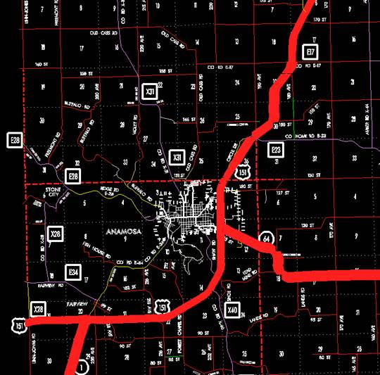
Transfer of jurisdiction agreement number 2003-TJ-004, between Jones
County and the Iowa Department of Transportation, transferred that portion of
US 151 from 840 feet south of the N ¼ Corner of Section 4-T85N-R3W; thence in a
northerly and northeasterly direction through Section 4-T85N-R3W and Sections
33, 34, and 27-T86N-R3W to the south corporation line of Monticello
(approximately 1230 feet north and 260 feet east of the SW Corner of Section
27-T86N-R3W) connecting with Main Street to county jurisdiction on October 11,
2004.
Transfer of
jurisdiction agreement number 2003-TJ-005, between the City of Monticello and
the Iowa Department of Transportation, transferred that portion of US 151 from
Main Street at the south corporation line; thence northeasterly on Main Street
to the east corporation line (approximately 860 feet south of the Center of
Section 22-T86N-R3W) to city jurisdiction on October 11, 3004.
Transfer of
jurisdiction agreement number 2003-TJ-004, between Jones County and the Iowa
Department of Transportation, transferred that portion of US 151 from the east
corporation line of Monticello connecting with Main Street; thence
northeasterly through Sections 22, 23, and 14-T86N-R3W to the junction of new
US 151 alignment (approximately 1420 feet north and 600 feet east of the S ¼
Corner of said Section 14 to county jurisdiction on October 11, 2004.
PROPOSAL/ACTION
RECOMMENDATION:
It is
recommended that the old description of US 151 and its extensions in
New
Description - US 151 and its extensions in
Beginning on
the Jones-Linn County line at a point approximately 300 feet south of the W ¼
Corner of Section 19-T84N-R4W, Jones County (E ¼ Corner of Section 24-T84N-R5W,
Linn County); thence in a northeasterly direction through Section 19-T84N-R4W
to a point approximately 1320 feet east of the W ¼ Corner of Section
19-T84N-R4W; thence easterly following substantially the center section line of
Sections 19, 20 (junction Iowa 1), 21, and 22-T84N-R4W to near the Center of
Section 22-T84N-R4W; thence in a northeasterly direction through Sections 22,
23, and 14-T84N-R4W to approximately 1330 feet south of the NE Corner of
Section 14-T84N-R4W; thence northerly following substantially the section line
of Sections 13 and 12-T84N-R4W to the south corporation line of Anamosa (approximately 1090 feet south of the NW
Corner of Section 12-T84N-R4W) connecting with an unnamed street (junction Iowa
64).
Anamosa:
Beginning on
the south corporation line connecting with an unnamed street (junction
Beginning
again on the north corporation line of Anamosa connecting with unnamed street ;
thence northerly following substantially the section line of Section 1-T84N-R4W
to approximately 1430 feet south of the NW Corner of Section 1-T84N-R4W; thence
in a northeasterly direction through Section 1-T84N-R4W and Sections 36 and
25-T85N-R4W and Section 30-T85N-R3W to a point approximately 400 feet south of
the center of Section 30-T85N-R3W; thence in a northerly and northeasterly
direction through Sections 30, 19, 20, 17, 8, 5, 4, and 3-T85N-R3W to the south
corporation line of Monticello (near the N ¼ Corner of said Section 3).
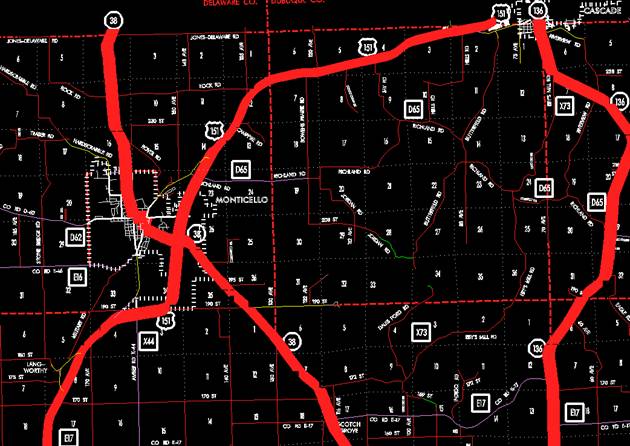
Beginning
on the south corporation line; thence northeasterly and northerly to the north
corporation line (approximately 2570 feet south and 1390 feet east of the NW
Corner of Section 23-T86N-R3W).
Beginning again on the north corporation line of Monticello; thence
northerly and northeasterly through Sections 23, 14, 13, and 12-T86N-R3W to
near the NE Corner of Section 12-T86N-R3W; thence easterly and northeasterly
through Sections 7, 6, 5, 4, 3, 2-T86N-R2W to the Jones-Dubuque County line
approximately 1060 feet west of the NE Corner of Section 2-T86N-R2W, Jones
County (SE Corner of Section 35-T87N-R2W, Dubuque County).
STAFF ACTION
OFFICE: Transportation Data
STAFF
ACTION NUMBER: S-03-0781
SUBMITTED
BY: Peggi Knight
SUBMITTAL
DATE: 04-15-2003
DISCUSSION/BACKGROUND:
Transfer of
jurisdiction agreement number 2001-TJ-005, between Jones County and the Iowa
Department of Transportation, transferred that portion of US 151 from
approximately 250 feet south of the N ¼ Corner of Section 2-T86N-R2W then
southeasterly and northeasterly to the west corporation line of Cascade
(approximately N ¼ Corner of Section 1-T86N-R2W), connecting with First Avenue
West to county jurisdiction on November 4, 2002.
Transfer of
jurisdiction agreement number 2001-TJ-006, between the City of Cascade and the
Iowa Department of Transportation, transferred that portion of US 151 from the
west corporation line (approximately N ¼ Corner of Section 1-T86N-R2W),
connecting with First Avenue West; thence easterly on First Avenue West
approximately 350 feet to a point on the Jones-Dubuque County line to city
jurisdiction on November 4, 2002.
PROPOSAL/ACTION
RECOMMENDATION:
It is
recommended that the old description of US 151 and its extensions in
New
Description - US 151 and its extensions in
Beginning on
the Jones-Linn County line at a point approximately 300 feet south of the W ¼
Corner of Section 19-T84N-R4W, Jones County (E ¼ Corner of Section 24-T84N-R5W,
Linn County); thence in a northeasterly direction through Section 19-T84N-R4W
to a point approximately 1320 feet east of the W ¼ Corner of Section
19-T84N-R4W; thence easterly following substantially the center section line of
Sections 19, 20 (junction Iowa 1), 21, and 22-T84N-R4W to near the Center of
Section 22-T84N-R4W; thence in a northeasterly direction through Sections 22,
23, and 14-T84N-R4W to approximately 1330 feet south of the NE Corner of
Section 14-T84N-R4W; thence northerly following substantially the section line
of Sections 13 and 12-T84N-R4W to the south corporation line of Anamosa (approximately 1220 feet south of the NW Corner
of Section 12-T84N-R4W) connecting with an unnamed street (junction Iowa 64).
Anamosa:
Beginning on
the south corporation line (approximately 1220 feet south of the NW Corner of Section
12-T84N-R4W) connecting with an unnamed street (junction Iowa 64); thence
northerly to the north corporation line (approximately 430 feet north of the NW
Corner of Section 12-T84N-R4W).
Beginning
again on the north corporation line of Anamosa (approximately 430 feet north of
the NW Corner of Section 12-T84N-R4W) connecting with unnamed street ; thence
northerly following substantially the section line of Section 1-T84N-R4W to
approximately 1430 feet south of the NW Corner of Section 1-T84N-R4W; thence in
a northeasterly direction through Section 1-T84N-R4W and Sections 36 and
25-T85N-R4W and Section 30-T85N-R3W to a point approximately 400 feet north of
the center of Section 30-T85N-R3W; thence in a northerly and northeasterly
direction through Sections 30, 19, 20, 17, 8, 5, and 4-T85N-R3W and Sections
33, 34, and 27-T86N-R3W to the south corporation line of Monticello
(approximately 1230 feet north and 260 feet east of the SW Corner of Section
27-T86N-R3W) connecting with Main Street.
Beginning on
Beginning
again on the east corporation line of Monticello connecting with Main Street;
thence northeasterly through Sections 22, 23, 14, 13, and 12-T86N-R3W to near
the NE Corner of Section 12-T86N-R3W; thence easterly and northeasterly through
Sections 7, 6, 5, 4, 3, 2-T86N-R2W to the Jones-Dubuque County line approximately
1060 feet west of the NE Corner of Section 2-T86N-R2W, Jones County (SE Corner
of Section 35-T87N-R2W, Dubuque County).
OFFICIAL
DESCRIPTION CHANGE
COUNTY:
Jones
ROUTE:
US 151
STAFF
ACTION NUMBER: S-87-1543
APPROVAL
DATE: 5-13-87
New
description ‑ US 151 and its extensions in
Beginning
on the Jones‑Linn County line at a point approximately 300 feet south of
the W ¼ Corner of Section 19‑T84N‑R4W, Jones County (E ¼ Corner of
Section 24‑T84N‑R5W, Linn County); thence in a northeasterly
direction through Section 19‑T84N‑R4W to a point approximately ¼
mile east of the W ¼ Corner of Section 19‑T84N‑R4W; thence easterly
following substantially the center section line of Sections 19, 20 (junction
Iowa 1), 21, and 22‑T84N‑R4W to a point approximately 2300 feet
east of the W ¼ Corner of Section 22‑T84N‑R4W; thence in a
northeasterly direction through Sections 22, 23, and 14‑T84N‑R4W to
a point approximately 650 feet south of the NE Corner of Section 14‑T84N‑R4W;
thence northerly following substantially the section line of Sections 13 and 12‑T84N‑R4W
to the south corporation line of Anamosa connecting with an unnamed street
(junction Iowa 64).
Anamosa:
Beginning on the south corporation line connecting with an unnamed street; thence northerly to the north corporation line connecting with an unnamed street.
Beginning
again on the north corporation line of Anamosa connecting with an unnamed
street; thence northerly following substantially the section line of Section 1‑T84N‑R4W
to a point approximately ¼ mile south of the NW Corner of Section 1‑T84N‑R4W;
thence in a northeasterly direction through Section 1‑T84N‑R4W and
Sections 36 and 25‑T85N‑R4W and Section 30‑T85N‑R3W to
a point approximately 400 feet north of the center of Section 30‑T85N‑R3W;
thence in a northerly and northeasterly direction through Sections 30, 19, 20,
17, 8, 5, and 4‑T85N‑R3W and Sections 33, 34, and 27‑T86N‑R3W
to the south corporation line of Monticello connecting with Main Street.
Beginning
on
Beginning
again on the east corporation line of Monticello connecting with Military Road;
thence in a northeasterly direction through Sections 22, 23, 14, 13, and 12‑T86N‑R3W
to a point on the east line of Section 12‑T86N‑R3W and continuing
in an easterly and northeasterly direction through Sections 7, 6, 5, 4, 3, 2,
and 1‑T86N‑R2W to the Jones‑Dubuque County line at a point approximately
500 feet west to the N ¼ Corner of Section 1‑T86N‑R2W, Jones County
(S ¼ Corner Section 36‑T87N‑R2W, Dubuque County); thence easterly
along the Jones‑Dubuque County line following substantially the section
line said Section 1 to the west corporation line of Cascade connecting with
First Avenue West.
Cascade:
Beginning
on
COMMISSION
ORDER
DIVISION:
Planning & Research
COMMISSION
ORDER NUMBER:
PR-79-272
SUBMITTED
BY: C.I. MacGillivray
MEETING
DATE: 11-2-78
DISCUSSION/BACKGROUND:
Due
to a review of our Primary Road System records, US 151 in Jones County should
be deleted from the Primary Road System and the new description added should be
officially included into the Primary Road System.
US
151, begins on the Jones‑Linn County line approximately 5 miles southwest
of Anamosa, Iowa and travels easterly and northeasterly via Anamosa and
Monticello to the Jones‑Dubuque County line in Cascade, Iowa.
PROPOSAL/ACTION
RECOMMENDATION:
Locate
US 151 and its extension in
Beginning
on the Jones‑Linn County line at a point approximately 300 feet south of
the W ¼ Corner of Section 19‑T84N‑R4W, Jones County (E ¼ Corner of
Section 24‑T84N‑R5W, Linn County); thence in a northeasterly
direction through Section 19‑T84N‑R4W to a point approximately ¼
mile east of the W ¼ Corner of Section 19‑T84N‑R4W; thence easterly
following substantially the center section line of Sections 19, 20 (junction
Iowa 1), 21 and 22‑T84N‑R4W to a point approximately 2300 feet east
of the W ¼ Corner of Section 22‑T84N‑R4W; thence in a northeasterly
direction through Sections 22, 23 and 14-T84N‑R4W to a point
approximately 650 feet south of the NE Corner of Section 14‑T84N‑R4W;
thence northerly following substantially the Section line of Sections 13 and 12‑T84N‑R4W
to the south corporation line of the City of Anamosa connecting with an unnamed
street (junction Iowa 64).
Anamosa:
Beginning
on the south corporation line connecting with an unnamed street; thence
northerly to the north corporation line connecting with an unnamed street.
Beginning
again on the north corporation line of the City of Anamosa connecting with an
unnamed street; thence northerly following substantially the section line of
Section 1‑T84N‑R4W to a point approximately ¼ mile south of the NW
Corner of Section 1‑T84N‑R4W; thence in a northeasterly direction
through Section 1‑T84N‑R4W and Sections 36 and 25‑T85N-R4W
and Section 30‑T85N‑R3W to a point approximately 400 feet north of
the center of Section 30‑T85N‑R3W; thence in a northerly and
northeasterly direction through Sections 30, 19, 20, 17, 8, 5, and 4‑T85N‑R3W
and Sections 33, 34, and 27‑T86N‑R3W to the south corporation line
of the City of Monticello, connecting with an unnamed street.
Beginning on the south corporation
line connecting with an unnamed street; thence northeasterly to the east
corporation line connecting with an unnamed street.
Beginning
again on the east corporation line of the City of Monticello, connecting with
an unnamed street; thence in a northeasterly direction through Sections 22, 23,
14, 13 and 12‑T86N‑R3W to a point on the east line of Section 12‑T86N‑R3W
and continuing in an easterly and northeasterly direction through Sections 7,
6, 5, 4, 3, 2, and 1‑T86N‑R2W to the Jones‑Dubuque County line
at a point approximately 500 feet west of the N ¼ Corner of Section 1‑T86N‑R2W,
Jones County (S ¼ Corner Section 36‑T87N‑R2W, Dubuque County)
thence easterly along the Jones‑Dubuque County line following
substantially the section line said Section 1 to the west corporation line of
the City of Cascade, connecting with an unnamed street.
Cascade:
Beginning
on the west corporation line connecting with an unnamed street; thence easterly
to a point on the Jones‑Dubuque County line. (NOTE:
NOW,
THEREFORE: Be it resolved that the Iowa Department of Transportation approve
the location of US 151 in Jones County,
NOTE:
To become effective upon the adoption of this resolution.
REVISED: 5-13-87
OFFICIAL
DESCRIPTION CHANGE
COUNTY: Jones
ROUTE:
US 151
APPROVAL
DATE: 11-4-64
Beginning
on the Jones‑Linn County line at a point approximately 300 feet south of
the W ¼ Corner Section 19‑T84N‑R4W, Jones County (E ¼ Corner
Section 24‑T84N-R5W, Linn County); thence in a northeasterly direction
to a point approximately ¼ mile east of the W ¼ Corner Section 19‑T84N‑R4W;
thence in an easterly direction following substantially the quarter section
line through Sections 19, 20, 21 and 22‑T84N‑R4W to a point
approximately 2,300 feet east of the W ¼ Corner Section 22‑T84N‑R4W;
thence northeasterly through Sections 22, 23, 14 and 13‑T84N‑R4W to
a point approximately 400 feet south of the N ¼ Corner Section 13‑T84N‑R4W;
thence in a northerly direction following substantially the section line to a
point approximately 1,650 feet north of the W ¼ Corner Section 12-T84N‑R4W
(junction Iowa 64 and Iowa 428); thence in a northerly direction following
substantially the section line to a point approximately 480 feet east and 515
feet south of the NW Corner Section 1‑T84N‑R4W; thence in a
northeasterly direction through Section 1‑T84N‑R4W, Sections 36 and
25‑T85N‑R4W, and Section 30-T85N-R3W to a point approximately 400
feet north of the center of Section 30-T85N-R3W; thence north following
substantially the quarter section line to a point approximately ¼ mile north of
the S ¼ Corner Section 19‑T85N‑R3W; thence in a northeasterly
direction to a point approximately 300 feet south of the NE Corner Section 19‑T85N‑R3W;
thence north following substantially the section line to a point approximately
500 feet north of the E ¼ Corner Section 18‑T85N‑R3W; thence in a
northeasterly and northerly direction through Sections 17 and 8‑T85N‑R3W
to a point on the south side of the Chicago, Milwaukee, St. Paul and Pacific
Railroad approximately ¼ mile south and 1,500 feet east of the NW Corner
Section 8‑T85N‑R3W; thence in a northeasterly and northerly
direction along the east side of said railroad and substantially parallel
thereto through Sections 8, 5 and 4‑T85N‑R3W and Sections 33, 34
and 27‑T86N‑R3W to a point approximately 1,000 feet north of the SW
Corner Section 27‑T86N‑R3W; thence in a northeasterly direction to
the south corporation line of the City of Monticello, connecting with Main
Street.
Beginning
again on the east corporation line of the City of Monticello, connecting with
Military Road; thence in a northeasterly direction through Sections 22, 23,
14, 13 and 12‑T86N‑R3W to a point near the NE Corner Section 12‑T86N‑R3W;
thence in an easterly and northeasterly direction through Sections 7, 6, 5, 4,
3, 2 and 1‑T86N‑R2W to the Jones‑Dubuque County Line at a
point approximately 500 feet west of the N ¼ Corner Section 1‑T86N‑R2W,
Jones County (S ¼ Corner Section 36‑T87N‑R2W, Dubuque County);
thence east along the Jones‑Dubuque County Line to the west corporation
line of the Town of Cascade connecting with Main Street (S ¼ Corner Section 36‑T87N‑R2W,
Dubuque County).
REVISED: 11-2-78
OFFICIAL
DESCRIPTION CHANGE
COUNTY:
Jones
CITY
OF:
ROUTE:
US 151
APPROVAL
DATE: 2-5-36
Commencing
on Main Street at the south corporation line; thence northeasterly on Main
Street to Military Road; thence northeasterly on Military Road to the east
corporation line.
REVISED: 11-2-78
OFFICIAL
DESCRIPTION CHANGE
COUNTY:
Jones
CITY
OF: Cascade
ROUTE:
US 151
APPROVAL
DATE: 2-5-36
NOTE:
Revised from US 161 to US 151 October 11, 1937.
REVISED: 11-4-64