OFFICIAL
DESCRIPTION CHANGE
OFFICE:
Transportation Data
ENTERED
BY: Stefani Wonders
ENTERED
DATE: 09-18-2006
DISCUSSION/BACKGROUND:
Due to a
review of our Primary System records, the primary route description for
Interstate 80 in Johnson
County was revised.
PROPOSAL/ACTION
RECOMMENDATION:
New
Description - Interstate 80 and its extensions in Johnson County
described as follows:
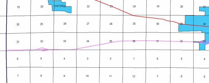
Beginning at
the Johnson‑Iowa County line at a point near the SW Corner Section 31‑T80N‑R8W,
Johnson County (SE Corner Section 36‑T80N‑R9W, Iowa County); thence
easterly following substantially the section line through Sections 31, 32, and
33‑T80N‑R8W to a point approximately 1970 feet west and 20 feet
north of the SE Corner Section 33‑T80N‑R8W; thence northeasterly
through Sections 33, 34 and 35‑T80N‑R8W to a point approximately
500 feet west and 20 feet north of the E ¼ Corner Section 35‑T80N‑R8W;
thence easterly following substantially the center section line through
Sections 35 and 36‑T80N‑R8W; Sections 31 and 32‑T80N‑R7W
to the west corporation line of Tiffin connecting with an unnamed street (a
point near the E ¼ Corner of said Section 32).
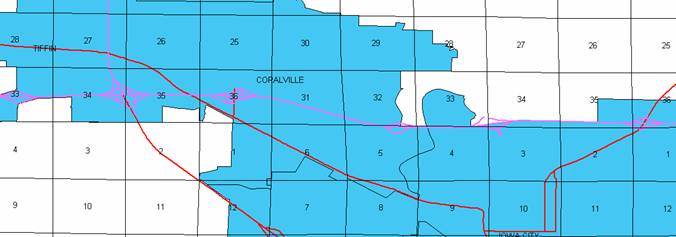
Tiffin:
Beginning on
an unnamed street at the west corporation line; thence easterly on said unnamed
street to the east corporation line/west corporation line of Coralville
connecting with an unnamed street (2561 feet south of the NW Corner Section
35-T80N‑R7W).
Coralville:
Beginning on
an unnamed street at the west corporation line/east corporation line of Tiffin;
thence easterly and southeasterly on said unnamed street through Sections 35
and 36-T80N‑R7W and Sections 31 and 32-T80N‑R6W to near the S ¼
Corner of said Section 32; thence easterly through Section 5 and 4-T79N-R6W to
the east corporation line/west corporation line of Iowa City connecting with an
unnamed street (approximately 964 feet east and 164 feet south of the NW Corner
of said Section 4).
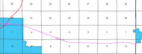
Iowa City:
Beginning on
an unnamed street at the west corporation line/east corporation line of
Coralville; thence easterly and northeasterly on said unnamed street through
Section 4-T79N‑R6W and Section 33‑T80N-R6W to the east corporation
line (approximately 1618 feet west of the SE Corner of said Section 33).
Beginning
again on the east corporation line of the City of Iowa City
connecting with an unnamed street; thence northeasterly and easterly through
Sections 33, 34, and 35‑T80N-R6W to the west corporation line of Iowa City connecting with
an unnamed street (approximately 467 feet north of the S ¼ Corner of said
Section 35).
Iowa City:
Beginning on
an unnamed street at the west corporation line; thence easterly on said unnamed
street to the east corporation line (approximately 205 feet south and 297 feet
east of the NW Corner Section 6‑T79N-R5W).
Beginning
again on the east corporation line of Iowa City connecting with an unnamed
street; thence southeasterly through Sections 6, 5, and 9-T79N-R5W; thence
easterly, northeasterly, and southeasterly through Sections 9, 10, 11 and 12‑T79N‑R5W
to a point on the Johnson‑Cedar County line approximately 1775 feet south
of the NE Corner Section 12‑T79N‑R5W, Johnson County (NW Corner
Section 7‑T79N‑R5W, Cedar County).
COMMISSION
ORDER
DIVISION:
Planning & Research
COMMISSION
ORDER NUMBER:
PR-79-272
SUBMITTED
BY: C.I. MacGillivray
MEETING
DATE: 11-2-78
DISCUSSION/BACKGROUND:
Due to a
review of our Primary Road System records Interstate 80 in Johnson County
should be deleted and the new description added should be officially included
into the Primary Road System.
PROPOSAL/ACTION
RECOMMENDATION:
It is recommended
that the old description of Interstate 80 in Johnson County
be deleted and the new description, as referred in the attached detailed
description, be included in the Primary Road System
effective upon the adoption of this resolution.
Locate Interstate
80 and its extensions in Johnson
County as follows:
Beginning at
the Johnson‑Iowa County line at a point approximately 218 feet north of
the SW Corner Section 31‑T80N‑R8W, Johnson County (SE Corner
Section 36‑T80N‑R9W, Iowa County); thence easterly following
substantially the section line through Sections 31 and 32‑T80N‑R8W
to a point approximately 176 feet north of the S ¼ Corner Section 32‑T80N‑R8W;
thence easterly following substantially the section line through Sections 32
and 33‑T80N‑R8W to a point approximately 1970 feet west and 20 feet
north of the SE Corner Section 33‑T80N‑R8W; thence northeasterly
through Sections 33, 34 and 35‑T80N‑R8W to a point approximately
500 feet west and 20 feet north of the E ¼ Corner Section 35‑T80N‑R8W;
thence easterly following substantially the center section line through
Sections 35 and 36‑T80N‑R8W; Sections 31, 32 and 33‑T80N‑R7W
to a point approximately 212 feet north of the center of Section 33‑T89N‑R7W;
thence easterly following substantially the center section line through
Sections 33, 34 (junction Interstate 330) and 35‑T80N‑R7W to the
west corporation line of the City of Coralville connecting with an unnamed
street.
Coralville:
Beginning on
an unnamed street at the west corporation line near the S ¼ Corner of the NE ¼
Section 35‑T80N‑R7W; thence easterly and southeasterly through
Sections 30, 31 and 32‑T80N‑R6W on unnamed street to the east
corporation line near the SW Corner of Section 33‑T80N‑R6W (Iowa
River) connecting with an unnamed street.
Beginning
again on the east corporation line of the City of Coralville connecting with an
unnamed street near the NW Corner of Section 4‑T79N‑R6W (Iowa
River); thence easterly through Section 4‑T79N‑R6W and Sections 33
and 34‑T80N‑R6W to a point approximately 300 feet east and 275 feet
north of the SW Corner Section 34‑T80N‑R6W; thence northeasterly
through Section 34‑T80N-R6W to a point approximately 590 feet north of
the S ¼ Corner Section 34‑T80N-R6W; thence easterly through Sections 34
and 35‑T80N‑R6W to the west corporation limits of the City of Iowa
City connecting with an unnamed street.
Iowa City:
Beginning on
an unnamed street at the west corporation line at a point near the S ¼ Corner
of Section 35‑T80N‑R7W; thence easterly and southeasterly through
Sections 35 and 36‑T80N-R6W, Section 1-T79N-R6W and Section 6-T79N-R5W to
the east corporation line connecting with an unnamed street.
Beginning
again on the east corporation line of the City of Iowa City connecting with an
unnamed street; thence southeasterly through Sections 6 and 5-T79N-R5W to
approximately the SE Corner Section 5-T79N-R5W; thence southeasterly through
Section 9‑T79N‑R5W and easterly, northeasterly, and southeasterly
through Sections 9, 10, 11 and 12‑T79N‑R5W to a point on the
Johnson‑Cedar County line approximately 1775 feet south of the NE Corner
Section 12‑T79N‑R5W, Johnson County (NW Corner Section 7‑T79N‑R5W,
Cedar County).
COMMISSION
ORDER
DIVISION:
Planning & Research
SUBMITTED
BY: Raymond L. Kassel
DISCUSSION/BACKGROUND:
Due to a
review of our Primary Road System records, Interstate 80 in Johnson County
should be deleted from the Primary Road System, and the new description added
should be officially included into the Primary Road System.
PROPOSAL/ACTION
RECOMMENDATION:
Locate
Interstate 80 in Johnson
County as follows:
Beginning at
the Johnson‑Iowa County line at a point approximately 218 feet north of
the SW Corner Section 31‑T80N‑R8W, Johnson County (SE Corner
Section 36‑T80N‑R9W, Iowa County); thence easterly following
substantially the section line through Sections 31 and 32‑T80N‑R8W
to a point approximately 176 feet north of the S ¼ Corner Section 32‑T80N-R8W;
thence easterly following substantially the section line through Sections 32
and 33‑T80N‑R8W to a point approximately 1970 feet west and 20 feet
north of the SE Corner Section 33‑T80N-R8W; thence northeasterly through
Sections 33, 34 and 35‑T80N‑R8W to a point approximately 500 feet
west and 20 feet north of the E ¼ Corner Section 35‑T80N-R8W; thence
easterly following substantially the quarter section line through Sections 35
and 36‑T80N‑R8W, Sections 31, 32 and 33‑T80N‑R7W to a
point approximately 212 feet north of the center of Section 33‑T80N‑R7W;
thence easterly following substantially the quarter section line through
Sections 33, 34, 35‑T80N‑R7W to a point approximately 900 feet from
the NE Corner of Section 35‑T80N‑R7W, the west city limits of the
City of Coralville connecting with an unnamed street.
Beginning
again on the east corporation line of the City of Coralville connecting with an
unnamed street near the SW Corner of Section 33-T80N‑R6W (Iowa River);
thence easterly through Sections 33 and 34‑T80N‑R6W to a point
approximately 300 feet east and 275 feet north of the SW Corner Section 34‑T80N-R6W;
thence northeasterly through Section 34‑T80N-R6W to a point approximately
590 feet north of the S ¼ Corner Section 34‑T80N‑R6W; thence
easterly through Sections 34 and 35-T80N-R6W to a point near the S ¼ Corner
Section 35 (west corporation limits of the City of Iowa City).
Beginning
again at the east corporation limits of the City of Iowa City near the NW
Corner of Section 6‑T79N‑R5W; thence southeasterly through Sections
6 and 5-T79N‑R5W to approximately the SE Corner Section 5‑T79N‑R5W;
thence southeasterly through Section 9‑T79N‑R5W to a point
approximately 2536 feet southeast of the NE Corner Section 9‑T79N‑R5W;
thence easterly, northeasterly, and southeasterly through Sections 9, 10, 11,
and 12 to a point on the Johnson‑Cedar County line approximately 1775
feet south of the NE Corner Section 12‑T79N‑R5W, Johnson County (NW
Corner Section 7‑T79N‑R4W, Cedar County).
Coralville:
Beginning on
an unnamed street at the west corporation line near the S ¼ Corner of the NE ¼
Section 35‑T80N‑R7W; thence easterly and southeasterly on unnamed
street to the east corporation limits near the SW Corner of Section 33‑T80N‑R6W
(Iowa River) connecting with an unnamed street.
Iowa City:
Beginning on
an unnamed street at the west corporation line at a point approximately on the
S ¼ Corner of Section 35‑T80N‑R7W; thence easterly and
southeasterly through Sections 35 and 36‑T80N‑R6W to the east
corporation line near a point in the NW Corner Section 6‑T79N‑R5W
connecting with an unnamed street.
NOW,
THEREFORE: Be it resolved that the Iowa
Department of Transportation approve the revision of Interstate 80 in Johnson County, Iowa.
NOTE: To become effective upon adoption of this
resolution.
REVISED: 1978
OFFICIAL
DESCRIPTION CHANGE
COUNTY:
Johnson
ROUTE:
Interstate 80
APPROVAL
DATE: 3-9-76
Beginning at
the Johnson‑Iowa County line at a point approximately 218 feet north of
the SW Corner Section 31‑T80N‑R8W, Johnson County (SE Corner
Section 36‑T80N‑R9W, Iowa County); thence easterly following
substantially the section line through Sections 31 and 32‑T80N‑R8W
to a point approximately 176 feet north of the S ¼ Corner Section 32‑T80N‑R8W;
thence easterly following substantially the section line through Sections 32
and 33‑T80N‑R8W to a point approximately 170 feet west and 20 feet
north of the SE Corner Section 33‑T80N-R8W; thence northeasterly through
Sections 33, 34, and 35‑T80N‑R8W to a point approximately 500 feet
west and 20 feet north of the E ¼ Corner Section 35‑T80N-R8W; thence
easterly following substantially the quarter section line through Sections 35
and 36‑T80N‑R8W, Sections 31, 32, and 33‑T80N‑R7W to a
point approximately 212 feet north of the center of Section 33‑T80N‑R7W;
thence easterly following substantially the quarter section line through
Sections 33, 34, 35‑T80N‑R7W to a point approximately 900 feet from
the NE Corner of Section 35‑T80N‑R7W, the west city limits of the
City of Coralville connecting with an unnamed street.
Coralville:
Beginning on
an unnamed street at the west corporation line near the S ¼ Corner of the NE ¼
Section 35‑T80N‑R7W; thence easterly and southeasterly on unnamed
street to the east corporation limits near the SW Corner of Section 33‑T80N‑R6W
(Iowa River) connecting with an unnamed street.
Beginning
again on the east corporation line of the City of Coralville connecting with an
unnamed street near the SW Corner of Section 33‑T80N‑R6W (Iowa
River); thence easterly through Sections 33 and 34‑T80N‑R6W to a
point approximately 300 feet east and 275 feet north of the SW Corner Section
34‑T80N-R6W; thence northeasterly through Section 34‑T80N‑R6W
to a point approximately 590 feet north of the S ¼ Corner Section 34‑T80N‑R6W;
thence easterly through Sections 34 and 35‑T80N‑R6W to a point near
the S ¼ Corner Section 35 (west corporation limits of the City of Iowa City).
Iowa City:
Beginning on
an unnamed street at the west corporation line at a point approximately on the
S ¼ Corner of Section 35‑T80N‑R7W; thence easterly and
southeasterly through Sections 35 and 36‑T80N‑R6W to the east
corporation line near a point in the NW Corner Section 6‑T79N‑R5W
connecting with an unnamed street.
Beginning
again at the east corporation limits of the City of Iowa City near the NW
Corner of Section 6‑T79N‑R5W; thence southeasterly through Sections
6 and 5‑T79N‑R5W to approximately the SE Corner Section 5‑T79N‑R5W;
thence southeasterly through Section 9‑T79N‑R5W to a point
approximately 2536 feet southeast of the NE Corner Section 9‑T79N‑R5W;
thence easterly, northeasterly, and southeasterly through Sections 9, 10, 11,
and 12-T79N-R5W to a point on the Johnson-Cedar County line approximately 1775
feet south of the NE Corner Section 12-T79N-R5W, Johnson County (NW Corner
Section 7‑T79N‑R4W, Cedar County).
OFFICIAL
DESCRIPTION CHANGE
COUNTY:
Johnson
ROUTE:
Interstate 80
APPROVAL
DATE: 11-28-62
Beginning at
the Johnson‑Iowa County line at a point approximately 218 feet north of
the SW Corner Section 31-T80N-R8W, Johnson County (SE Corner Section 36‑T80N‑R9W,
Iowa County); thence easterly following substantially the section line through
Section 31 and 32-T80N‑R8W to a point approximately 176 feet north of the
S ¼ Corner Section 32‑T80N‑R8W; thence easterly following
substantially the section line through Section 32 and 33‑T80N‑R8W
to a point approximately 1970 feet west and 20 feet north of the SE Corner
Section 33-T80N‑R8W; thence northeasterly through Sections 33, 34 and 35‑T80N-R8W
to a point approximately 500 feet west and 20 feet north of the E ¼ Corner
Section 35‑T80N‑R8W; thence easterly following substantially the
quarter section line through Sections 35 and 36-T80N‑R8W, Sections 31, 32
and 33‑T80N‑R7W to a point approximately 212 feet north of the
center of Section 33‑T80N‑R7W; thence easterly following
substantially the quarter section line through Sections 33, 34, 35 and 36‑T80N‑R7W
to a point approximately 2633 feet south of the N ¼ Corner Section 36‑T80N‑R7W;
thence easterly following substantially, the quarter section line through
Section 36‑T80N‑R7W to a point approximately 1240 feet west of the
E ¼ Corner Section 36‑T80N‑R7W; thence southeasterly through
Section 36‑T80N‑R7W, Section 31, 32‑T80N-R6W and Section 5‑T79N‑R6W
to the west corporation line of the Town of Coralville connecting with an
unnamed street at a point approximately 900 feet east and 110 feet south of
the NW Corner Section 5‑T79N‑R6W.
Coralville:
Commencing
on an unnamed street at the west corporation line at a point approximately 900
feet east and 110 feet south of the N ¼ Corner Section 5‑T79N‑R6W;
thence easterly on unnamed street through Section 5 and 4‑T79N‑R6W
to the east corporation line at a point approximately 450 feet east and 170
feet south of the NE Corner Section 5‑T79N‑R6W.
Beginning
again on the east corporation line of the Town of Coralville connecting with an
unnamed street at a point approximately 450 feet east and 170 feet south of the
NE Corner Section 5-T79N‑R6W; thence easterly through Section 4‑T79N‑R6W
to a point approximately 38 feet east and 170 feet south of the N ¼ Corner
Section 4‑T79N‑R6W; thence northeasterly through Section 4‑T79N‑R6W,
Sections 33 and 34‑T80N‑R6W to a point approximately 306 feet east
and 275 feet north of the SW Corner Section 34‑T80N‑R6W; thence
northeasterly through Section 34‑T80N‑R6W to a point approximately
590 feet north of the S ¼ Corner Section 34‑T80N‑R6W; thence
easterly through Sections 34, 35 and 36‑T80N‑R6W to a point
approximately 815 feet, east and 400 feet north of the SW Corner Section 36‑T80N‑R6W;
thence easterly through Section 36‑T80N‑R6W to a point
approximately 1885 feet west and 300 feet north of the NE Corner Section 1‑T79N‑R6W;
thence southeasterly through Section 36‑T80N‑R6W, Section 1‑T79N‑R6W,
Sections 6 and 5-T79N-R5W to approximately the SE Corner Section 5-T79N-R5W;
thence southeasterly through Section 9‑T79N‑R5W to a point approximately
2536 feet southeast of the NE Corner Section 9‑T79N‑R5W; thence
easterly, northeasterly and southeasterly through Sections 9, 10, 11 and 12 to
a point on the Johnson‑Cedar County line approximately 1775 feet south of
the NE Corner Section 12‑T79N‑R5W, Johnson County (NW Corner
Section 7‑T79N‑R4W, Cedar County).