OFFICIAL
DESCRIPTION CHANGE
OFFICE:
Transportation Data
EFFECTIVE DATE: 07-01-2003
ENTERED
BY: Stefani Wonders
ENTERED
DATE: 08-24-2006
DISCUSSION/BACKGROUND:
Senate File 451 transferred Iowa
428 in its entirety, in Jackson
County, to county
jurisdiction on July 1, 2003.
OFFICIAL DESCRIPTION CHANGE
COUNTY: Jackson
ROUTE: Iowa 428
STAFF
ACTION NUMBER: S-87-725
APPROVAL
DATE: 12-18-86
New
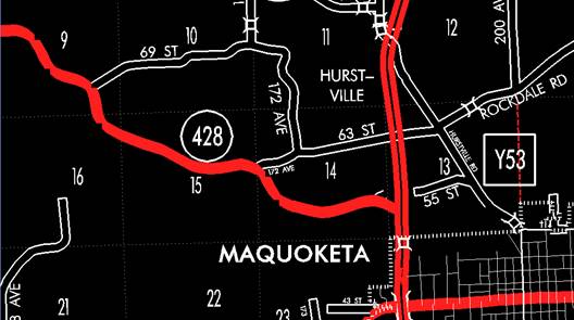
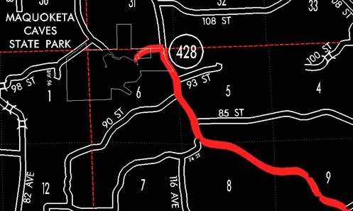
description ‑ Iowa 428 in Jackson County described as follows:
Beginning at
a point approximately 750 feet south and 400 feet east of the W ¼ Corner
Section 13‑T84N‑R2E (junction US 61); thence northwesterly through
Sections 13, 14, 15, 16, 9, 8, 5, and 6‑T84N‑R2E to a point in the
north part of Section 6‑T84N‑R2E (north boundary of the Maquoketa
Caves State Park).
COMMISSION
ORDER
DIVISION:
Planning & Research
COMMISSION
ORDER NUMBER:
PR-81-631
SUBMITTED
BY: Patrick R. Cain
MEETING
DATE: 4-14-81
DISCUSSION/BACKGROUND:
Transfer of
jurisdiction agreement number TJ‑000‑0 (1) ‑‑2M‑49
between Jackson County and the Iowa Department of Transportation, transferred
the county road from the north boundary of the Maquoketa Caves State Park in
the north part of Section 6‑T84N‑R2E easterly, southeasterly and
easterly to a junction with US 61 approximately 750 feet south and 400 feet
east of the W ¼ Corner Section 13‑T84N‑R2E to said jurisdiction on
October 1, 1980. This road section is now designated as Iowa 428.
Iowa 428 begins at the north boundary of
the Maquoketa Caves
State Park approximately six miles
northwest of the City of Maquoketa and proceeds
southeasterly to a junction with US 61 near the City of Maquoketa.
PROPOSAL/ACTION
RECOMMENDATION:
It is
recommended the commission approve including the attached description of Iowa 428 in Jackson
County in the primary
road system.
Locate Iowa 428 and its extension in Jackson County
as follows:
Beginning on
the north boundary of the Maquoketa Caves State Park in the north part of
Section 6‑T84N‑R2E; thence in an easterly, southeasterly and
easterly direction through Sections 6, 5, 8, 9, 16, 15, 14 and 13‑T84N‑R2E
to a point approximately 750 feet south and 400 feet east of the W ¼ Corner
Section 13‑T84N‑R2E (junction US 61).
REVISED:
12-18-86