OFFICIAL
DESCRIPTION CHANGE
OFFICE:
Analytics
EFFECTIVE
DATE: 9-1-2017
ENTERED
BY: Paul
Mauer
ENTERED
DATE: 8-12-2020
DISCUSSION/BACKGROUND:
Co.
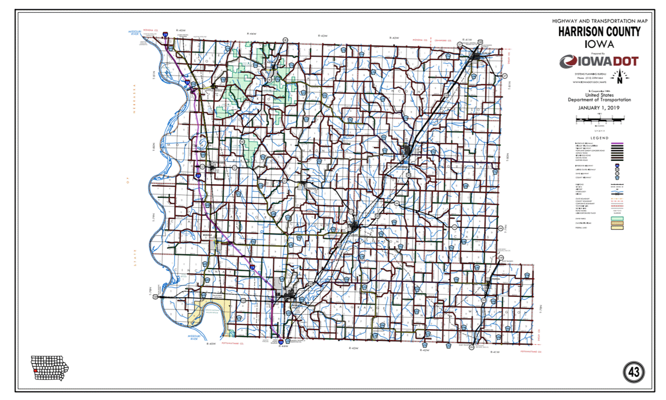
Res17-02-01 Severence of ten properties in Pisgah
have impacted the route description.
New
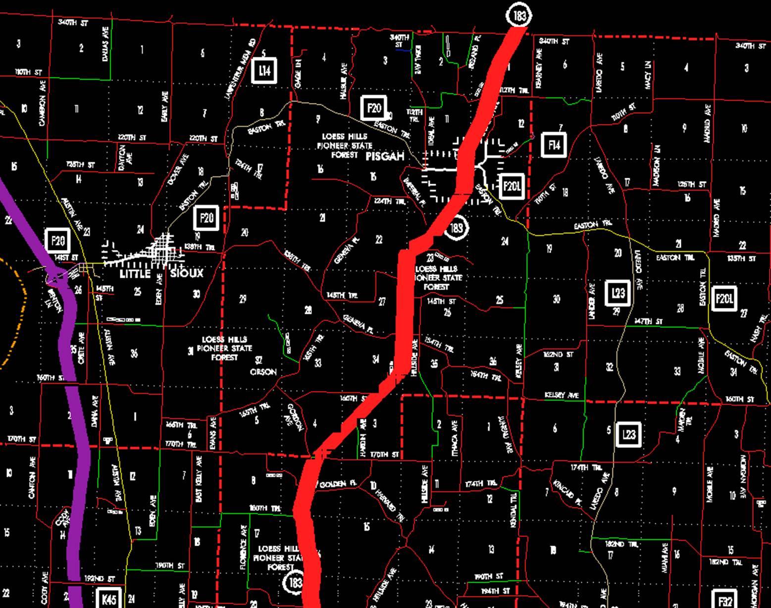
Description Iowa 183 and its extensions in
Beginning
at the junction of Iowa 127 at a point approximately 600 feet west of the E ¼
Corner of Section 28‑T80N‑R44W; thence in a northwesterly and
northerly direction through Sections 28, 21, 16, and 9‑T80N‑R44W;
thence in a northeasterly direction through Sections 4 and 3‑T80N‑R44W
and Section 34‑T81N‑R44W to a point near the W ¼ Corner Section 35‑T81N‑R44;
thence north following substantially the section line of Sections 35, 26, and
23‑T81N‑R44W to a point approximately 1,300 feet north of the SW
Corner of Section 23‑T81N‑R44W; thence in a northeasterly and
northerly direction through Sections 23 and 14‑T81N‑R44W to the
south corporation line of Pisgah, connecting with 1st Street (approximately
1320 feet north and 950 feet west of the SE Corner of Section 14-T81N-R44W).
Pisgah:
Beginning
on
Beginning
again on the north corporation line of Pisgah connecting with 1st Street;
thence in a northeasterly direction through Section 12 and 1‑T81N‑R44W
to the Harrison‑Monona County line at a point approximately 1,000 feet
east of the N ¼ Corner of Section 1‑T81N‑R44W Harrison County, (S ¼
Corner of Section 36‑T82N‑R44W, Monona County).
OFFICIAL
DESCRIPTION CHANGE
OFFICE: Transportation Data
EFFECTIVE DATE: 07-01-2003
ENTERED
BY: Stefani Wonders
ENTERED
DATE: 01-24-2005
DISCUSSION/BACKGROUND:
Senate File 451 transferred
New
Description Iowa 183 and its extensions in
Beginning
at the junction of Iowa 127 at a point approximately 600 feet west of the E ¼
Corner of Section 28‑T80N‑R44W; thence in a northwesterly and
northerly direction through Sections 28, 21, 16, and 9‑T80N‑R44W;
thence in a northeasterly direction through Sections 4 and 3‑T80N‑R44W
and Section 34‑T81N‑R44W to a point near the W ¼ Corner Section 35‑T81N‑R44;
thence north following substantially the section line of Sections 35, 26, and
23‑T81N‑R44W to a point approximately 1,300 feet north of the SW
Corner of Section 23‑T81N‑R44W; thence in a northeasterly and
northerly direction through Sections 23 and 14‑T81N‑R44W to the
south corporation line of Pisgah, connecting with 1st Street (approximately
1320 feet north and 950 feet west of the SE Corner of Section 14-T81N-R44W).
Pisgah:
Beginning
on
Beginning
again on the north corporation line of Pisgah connecting with 1st Street;
thence in a northeasterly direction through Section 12 and 1‑T81N‑R44W
to the Harrison‑Monona County line at a point approximately 1,000 feet
east of the N ¼ Corner of Section 1‑T81N‑R44W Harrison County, (S ¼
Corner of Section 36‑T82N‑R44W, Monona County).
OFFICIAL
DESCRIPTION CHANGE
COUNTY:
ROUTE:
STAFF
ACTION NUMBER: S-87-732
APPROVAL
DATE: 12-18-86
New
Description -
Beginning
on the Harrison‑Pottawattamie County line on the south line of Section 34‑T78N‑R44W,
Beginning on
Beginning
again on the north corporation line of Missouri Valley, connecting with 1st
Street; thence in a northerly direction through Sections 10, 9, 4, and 3‑T78N‑R44W
and in a northerly direction through Sections 31 and 30‑T79N‑R43W
to a point approximately 1,700 feet south of N ¼ Corner Section 30‑T79N‑R43W;
thence northwesterly through Sections 30 and 19‑T79N‑R43W and
continuing in a northwesterly direction through Sections 24, 13, 14, 11, 2, and
3‑T79N‑R44W, and in a northerly and northwesterly direction through
Sections 34 and 27‑T80N‑R44W to a point approximately 800 feet east
of the W ¼ Corner of Section 27‑T80N‑R44W; thence curving in a
northwesterly direction to a point approximately 100 feet west and 600 feet
north of the E ¼ Corner of Section 28‑T80N‑R44W; thence in a
northwesterly and northerly direction through Sections 28, 21, 16, and 9‑T80N‑R44W
and in a northeasterly direction through Sections 4 and 3‑T80N‑R44W
and Section 34‑T81N‑R44W to a point near the W ¼ Corner Section 35‑T81N‑R44;
thence north following substantially the section line of Sections 35, 26, and
23‑T81N‑R44W to a point approximately 1,300 feet north of the SW
Corner of Section 23‑T81N‑R44W; thence in a northeasterly and
northerly direction through Sections 23 and 14‑T81N‑R44W to the
south corporation line of Pisgah, connecting with 1st Street.
Pisgah:
Beginning
on
Beginning
again on the north corporation line of Pisgah connecting with 1st Street;
thence in a northeasterly direction through Section 12 and 1‑T81N‑R44W
to the Harrison‑Monona County line at a point approximately 1,000 feet
east of the N ¼ Corner of Section 1‑T81N‑R44W Harrison County (S ¼
Corner of Section 36‑T82N‑R44W, Monona County).
COMMISSION
ORDER
DIVISION: Planning & Research
COMMISSION
ORDER NUMBER:
PR-79-272
SUBMITTED
BY: C.I. MacGillivray
MEETING
DATE:
11-2-78
DISCUSSION/BACKGROUND:
Due
to a review of our Primary Road System Records,
PROPOSAL/ACTION
RECOMMENDATION:
Locate
Beginning
on the Harrison‑Pottawattamie County line on the south line of Section 34‑T78N‑R44W,
Beginning
at the south corporation line connecting with an unnamed street; thence
northerly, westerly and northerly to the north corporation line, connecting
with an unnamed street.
Beginning
again on the north corporation line of the City of Missouri Valley, connecting
with an unnamed street; thence in a northerly direction through Section 10, 9,
4, and 3‑T78N‑R44W and in a northerly direction through Sections 31
and 30‑T79N‑R43W to a point approximately 1700 feet south of N ¼ Corner
Section 30‑T79N‑R43W; thence northwesterly through Sections 30 and
19‑T79N‑R43W and continuing in a northwesterly direction through
Section 24, 13, 14, 11, 2, and 3‑T79N‑R44W, and in a northerly and
northwesterly direction through Section 34 and 27‑T80N‑R44W to a
point approximately 800 feet east of the W ¼ Corner of Section 27‑T80N‑R44W;
thence curving in a northwesterly direction to a point approximately 100 feet
west and 600 feet north of the E ¼ Corner of Section 23‑T80N‑R44W;
thence in a northwesterly and northerly direction through Section 28, 21, 16,
and 9‑T80N‑R44W and in a northeasterly direction through Section 4
and 3‑T80N-R44W and Section 34‑T81N‑R44W to a point near the
W ¼ Corner Section 35‑T81N‑R44W; thence north following
substantially the section line of Section 35, 26, and 23-T81N‑R44W to a
point approximately 1300 feet north of the SW Corner of Section 23‑T81N‑R44W;
thence in a northeasterly and northerly direction through Section 23 and 14‑T81N‑R44W
to the south corporation line of the City of Pisgah, connecting with an unnamed
street.
Pisgah:
Beginning
on the south corporation line connecting with an unnamed street; thence
northeasterly, northerly and northeasterly to the north corporation line
connecting with an unnamed street.
Beginning
again on the north corporation line of the City of Pisgah connecting with an
unnamed street thence in a northeasterly direction through Section 12 and 1‑T81N‑R44W
to the Harrison‑Monona County line at a point approximately 1000 feet
east of the N ¼ Corner of Section 1‑T81N‑R44W Harrison County (S ¼
Corner of Section 36‑T82N‑R44W Monona County).
NOW,
THEREFORE: Be it resolved that the Iowa
Department of Transportation approve the location of
NOTE: To become effective upon the adoption of this
resolution.
REVISED: 12-18-86
OFFICIAL
DESCRIPTION CHANGE
COUNTY:
ROUTE:
APPROVAL
DATE: 11-19-69
Beginning
on the Harrison‑Pottawattamie County line on the south line of Section 34‑T78N‑R44W,
Beginning
again on the north corporation line of the City of Missouri Valley, connecting
with McGavren Street; thence in a northerly direction through Section 10, 9 and
3‑T78N‑R44W, and in a northerly and northwesterly direction through
Section 31, 30 and 19‑T79N‑R43W, in a northwesterly direction
through Section 24, 13, 14, 11, 2 and 3‑T79N‑R44W, and in a
northerly and northwesterly direction through Section 34 and 27‑T80N‑R44W
to a point approximately 800 feet east of the W ¼ Corner of Section 27‑T80N‑R44W;
thence curving in a northwesterly direction to a point approximately 100 feet
west and 600 feet north of the E ¼ Corner of Section 28‑T80N‑R44W;
thence in a northwesterly and northerly direction through Section 28, 21, 16,
and 9‑T80N‑R44W and in a northeasterly direction through Section 4
and 3‑T80N‑R44W and Section 34-T81N‑R44W to a point near the
E ¼ Corner of Section 34‑T81N‑R44W; thence north following
substantially the section line to a point approximately ¼ mile north of the SW
Corner of Section 23‑T81N‑R44W; thence in a northeasterly and
northerly direction through Section 23 and 14‑T81N‑R44W to the
south corporation line of the Town of Pisgah, connecting with an unnamed street.
Beginning
again on the north corporation line of the Town of Pisgah on the west side of
the Chicago and Northwestern Railway; thence in a northeasterly direction
along the west side of said railroad and substantially parallel thereto through
Section 12 and 1‑T81N‑R44W to the Harrison‑Monona County line
at a point approximately 1000 feet east of the N ¼ Corner of Section 1‑T81N‑R44W,
Harrison County (S ¼ Corner of Section 36‑T82N‑R44W Monona County).
OFFICIAL
DESCRIPTION CHANGE
COUNTY:
CITY
OF:
ROUTE:
APPROVAL
DATE: 11-19-69
Beginning
on Sixth Street at the south corporation line; thence north on Sixth Street to
Erie Street; thence west on Erie Street to First Street; thence northerly on
First Street to Michigan Street; thence westerly on Michigan Street to McGavren
Street; thence northerly on McGavren Street to the north corporation line.
COMMISSION
RESOLUTION
DIVISION: Planning & Research
COMMISSION
ORDER NUMBER:
69-1588
SUBMITTED
BY: Raymond L. Kassel
MEETING
DATE:
11-19-69
Locate
Beginning
on the Harrison‑Pottawattamie County line on the south line of Section 34‑T78N‑R44W,
Beginning
on
NOW
THEREFORE: Be it resolved that the Iowa
State Highway Commission approve the location of
NOTE: To become effective upon adoption of this
resolution.
OFFICIAL
DESCRIPTION CHANGE
COUNTY:
CITY
OF:
ROUTE:
APPROVAL
DATE: 4-2-69
Beginning
on First Street at the north line of Erie Street; thence northerly on First
Street to Michigan Street; thence westerly on Michigan Street to McGavren
Street; thence northerly on McGavren Street to the north corporation line.
COMMISSION
RESOLUTION
DIVISION: Planning & Research
COMMISSION
ORDER NUMBER:
69-374
SUBMITTED
BY: Raymond Kassel
MEETING
DATE:
4-2-69
Locate
Beginning
again on the north corporation line of the City of Missouri Valley, connecting
with McGavren Street; thence in a northerly direction through Section 10, 9 and
3-T78N-R44W, and in a northerly and northwesterly direction through Section 31,
30 and 19‑T79N‑R43W, in a northwesterly direction through Section
24, 13, 14, 11, 2 and 3‑T79N‑R44W, and in a northerly and
northwesterly direction through Section 34 and point approximately 800 feet
east of the 27‑T80N‑R44W to a point approximately 800 feet east of
the W ¼ Corner of Section 27-T80N-R44W.
Beginning
on First Street at the north line of Erie Street; thence northerly on First
Street to Michigan Street; thence westerly on Michigan Street to McGavren
Street; thence northerly on McGavren Street to the north corporation line.
NOW
THEREFORE: Be it resolved that the Iowa
State Highway Commission approve the location of
NOTE: To become effective upon adoption of this
resolution.
OFFICIAL
DESCRIPTION CHANGE
COUNTY:
ROUTE:
APPROVAL
DATE: 4-2-69
Beginning
again on the north corporation line of the City of Missouri Valley, connecting
with McGavren Street; thence in a northerly direction through Section 10, 9 and
3-T78N‑R44W, and in a northerly and northwesterly direction through
Section 31, 30 and 19‑T79N‑R43W, in a northwesterly direction
through Section 24, 13, 14, 11, 2 and 3‑T79N‑R44W, and in a
northerly and northwesterly direction through Section 34 and 27‑T80N‑R44W
to a point approximately 800 feet east of the W ¼ Corner of Section 27‑T80N‑R44W;
thence curving in a northwesterly direction to a point approximately 100 feet
west and 600 feet north of the E ¼ Corner of Section 28-T80N‑R44W; thence
in a northwesterly and northerly direction through Section 28, 21, 16, and 9‑T80N‑R44W
and in a northeasterly direction through Section 4 and 3‑T80N‑R44W
and Section 34‑T81N‑R44W to a point near the E ¼ Corner of Section
34‑T81N-R44W; thence north following substantially the section line to a
point approximately ¼ mile north of the SW Corner of Section 23‑T81N‑R44W;
thence in a northeasterly and northerly direction through Section 23 and 14‑T81N‑R44W
to the south corporation line of the Town of Pisgah, connecting with an unnamed
street at a point approximately 1500 feet north and 950 feet west of the SE
Corner of Section 14‑T81N‑R44W.
Beginning
again on the North corporation line of the Town of Pisgah on the west side of
the Chicago and Northwestern Railway; thence in a northeasterly direction along
the west side of said railroad and substantially parallel thereto through
Section 12 and 1‑T81N‑R44W to the Harrison-Monona County line at a
point approximately 1000 feet east of the N ¼ Corner of Section 1‑T81N‑R44W,
Harrison County (S ¼ Corner of Section 36‑T82N‑R44W, Monona
County).
OFFICIAL
DESCRIPTION CHANGE
COUNTY:
APPROVAL
DATE: 12-31-68
Connecting
Curves
Junction
of US 75 and
Beginning
at a point approximately 700 feet west of the E ¼ Corner of Section
28-T80N-R44W; thence curving in a northeasterly direction to a point
approximately 100 feet west and 600 feet north of the E ¼ Corner of Section
28-T80N-R44W (See rural description
OFFICIAL
DESCRIPTION CHANGE
COUNTY:
CITY
OF: Pisgah
ROUTE:
APPROVAL
DATE: 6-1-54
Beginning
on the south corporation line; thence northeasterly and northerly along First
Street; to the north corporation line of Pisgah.
OFFICIAL
DESCRIPTION CHANGE
COUNTY:
APPROVAL
DATE: 4-2-41
CONNECTING
CURVE
Junction
Beginning
at a point approximately 900 feet north and 900 feet west of the E ¼ Corner
Section 34‑T80N‑R44W; thence curving in a southeasterly direction
to a point approximately 600 feet north and 600 feet west of the E ¼ Corner
Section 34-T80N-R44W.