OFFICIAL
DESCRIPTION CHANGE
OFFICE:
Transportation Data
ENTERED
BY: Stefani Wonders
ENTERED
DATE: 09-14-2006
DISCUSSION/BACKGROUND:
Due to a review
of our Primary System records, the primary route description for Interstate 29
in
PROPOSAL/ACTION
RECOMMENDATION:
New
Description - Interstate 29 and its extensions in
Beginning
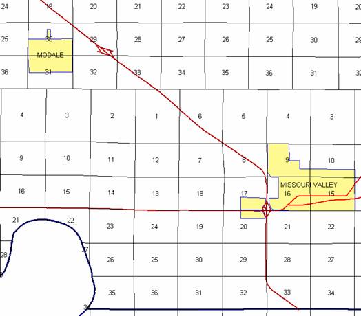
on the Harrison‑Pottawattamie County line at a point approximately 2042
feet west of the SE Corner Section 33‑T78N‑R44W, Harrison County
(NE Corner Section 4‑T77N-R44W, Pottawattamie County); thence in a
northwesterly direction to a point approximately 951 feet south of the NW
Corner Section 33‑T78N‑R44W; thence continuing in a northwesterly
and northerly direction through Section 32‑T78N‑R44W to a point
near the NE Corner Section 32‑T78N‑R44W; thence in a northerly
direction through Sections 29 and 20‑T78N‑R44W to a point near the
NE Corner Section 20‑T78N‑R44W (junction US 30); thence in a
northerly and northwesterly direction through Sections 17, 8, 5, and 6‑T78N‑R44W,
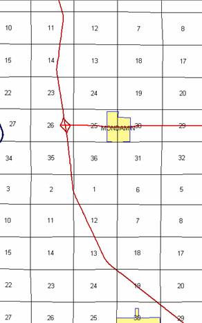
Section 1-T78N‑R45W, Sections 33, 32, 29, 30, and 19‑T79N-R44W; thence
continuing in a northwesterly and northerly direction through Sections 24, 13,
12, 1, and 2‑T79N‑R45W, Sections 35, 26, 23, 14, 11, and 2-T80N-R45W,
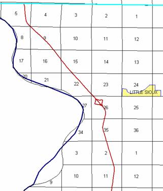
and Sections 35, 26, 23, 22, 15, 16, 9, 4 and 5‑T81N‑R45W to the
Harrison-Monona County line 1744 feet west and 224 feet south of the NE Corner
Section 5‑T81N‑R45W, Harrison County.
COMMISSION
ORDER
DIVISION:
Planning & Research
COMMISSION
ORDER NUMBER:
PR-79-272
SUBMITTED
BY: C.I. MacGillivray
MEETING
DATE: 11-2-78
DISCUSSION/BACKGROUND:
Due
to a review of our Primary Road System Records Interstate 29 in
Interstate
29 begins on the Harrison‑Pottawattamie County line approximately 3 ½
miles south and 1 mile west of
PROPOSAL/ACTION
RECOMMENDATION:
Locate
Interstate 29 in
Beginning
on the Harrison‑Pottawattamie County line at a point approximately 1400
feet west of the SE Corner Section 33‑T78N‑R44W Harrison County (NE
Corner Section 4‑T77N-R44W Pottawattamie County); thence in a
northwesterly direction to a point approximately 700 feet south of the NW
Corner Section 33‑T78N‑R44W; thence continuing in a northwesterly
and northerly direction through Section 32‑T78N‑R44W to a point
near the NE Corner Section 32‑T78N‑R44W; thence in a northerly
direction through Sections 29 and 20‑T78N‑R44W to a point near the
NE Corner Section 20‑T78N‑R44W (junction US 30); thence in a
northerly direction through Section 17‑T78N‑R44W to a point near
the NE Corner of Section 17‑T78N‑R44W; thence in a northwesterly
direction through Sections 3, 5, and 6-T78N-R44W; thence continuing in a
northwesterly direction through Section 1-T78N‑R45W and Sections 33, 32,
29, 30, and 19‑T79N-R44W; thence continuing in a northwesterly direction
through Sections 24, 13, 12, and 1‑T79N‑R45W to a point near the W
¼ Corner Section 1‑T79N‑R45W; thence in a northerly direction through
Section 2‑T79N‑R45W and Sections 35, 26, 23, 14 and 11‑T80N‑R45W;
thence in a northerly, northwesterly and northerly direction through Sections
2-T80N-R45W and Sections 35, 26, 23, 22, 15, 16, 9, 4 and 5‑T81N‑R45W
to the Harrison-Monona County line near the NE Corner Section 5‑T81N‑R45W.
NOW,
THEREFORE: Be it resolved that the Iowa
Department of Transportation approve the location of Interstate 29,
NOTE: To become effective upon the adoption of this
resolution.
OFFICIAL
DESCRIPTION CHANGE
COUNTY:
ROUTE:
Interstate 29
APPROVAL
DATE: 12-7-66
Beginning
on the Harrison‑Pottawattamie County line at a point approximately 1400
feet west of the SE Corner Section 33‑T78N‑R44W Harrison County (NE
Corner Section 4-T77N‑R44W Pottawattamie County); thence in a
northwesterly direction to a point approximately 700 feet south of the NW
Corner Section 33‑T78N‑R44W; thence continuing in a northwesterly
and northerly direction thru Section 32‑T78N‑R44W to a point 45
feet west of the NE Corner Section 32‑T78N‑R44W; thence in a
northerly direction thru Sections 29 and 20‑T78N‑R44W to a point
near the NE Corner Section 20‑T78N‑R44W; thence in a northerly
direction to a point near the NE Corner Section 17‑T78N‑R44W;
thence in a northwesterly direction through Sections 8, 5, and 6‑T78N‑R44W;
thence continuing in a northwesterly direction through Section 1‑T78N‑R45W
and Sections 33, 32, 29, 30, and 19‑T79N‑R44W; thence continuing in
a northwesterly direction through Sections 24, 13, 12, and 1‑T79N‑R45W
to a point near the SW Corner NW ¼ Section 1‑T79N‑R45W; thence in a
northerly direction through Section 2‑T79N‑R45W and Sections 35,
26, 23, 14, and 11‑T80N‑R45W; thence in a northerly, northwesterly
and northerly direction through Sections 2, 35, 26, 23, 22, 15, 16, 9, and 5‑T81N‑R45W
to the Monona County line near the NE Corner Section 5‑T81N‑R45W.