OFFICIAL DESCRIPTION
CHANGE
OFFICE: Research and Analytics
EFFECTIVE DATE: 8-22-2003
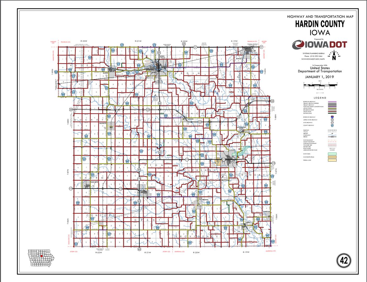
COUNTY: Hardin
ROUTE: US 65
ENTERED BY: Paul Mauer
ENTERED DATE: 11-22-2019
New
Description ‑ US 65 and its extensions in Hardin County
described as follows:
Beginning
on the Hardin‑Story County line at a point near the SW Corner Section 33‑T86N‑R21W,
Hardin County
(NW Corner Section 4‑T85N‑R21W, Story County);
thence north following substantially the section line of Sections 33, 28, 21,
16, 9, and 4‑T86N‑R21W to the south corporation line of Hubbard
connecting with an unnamed street.
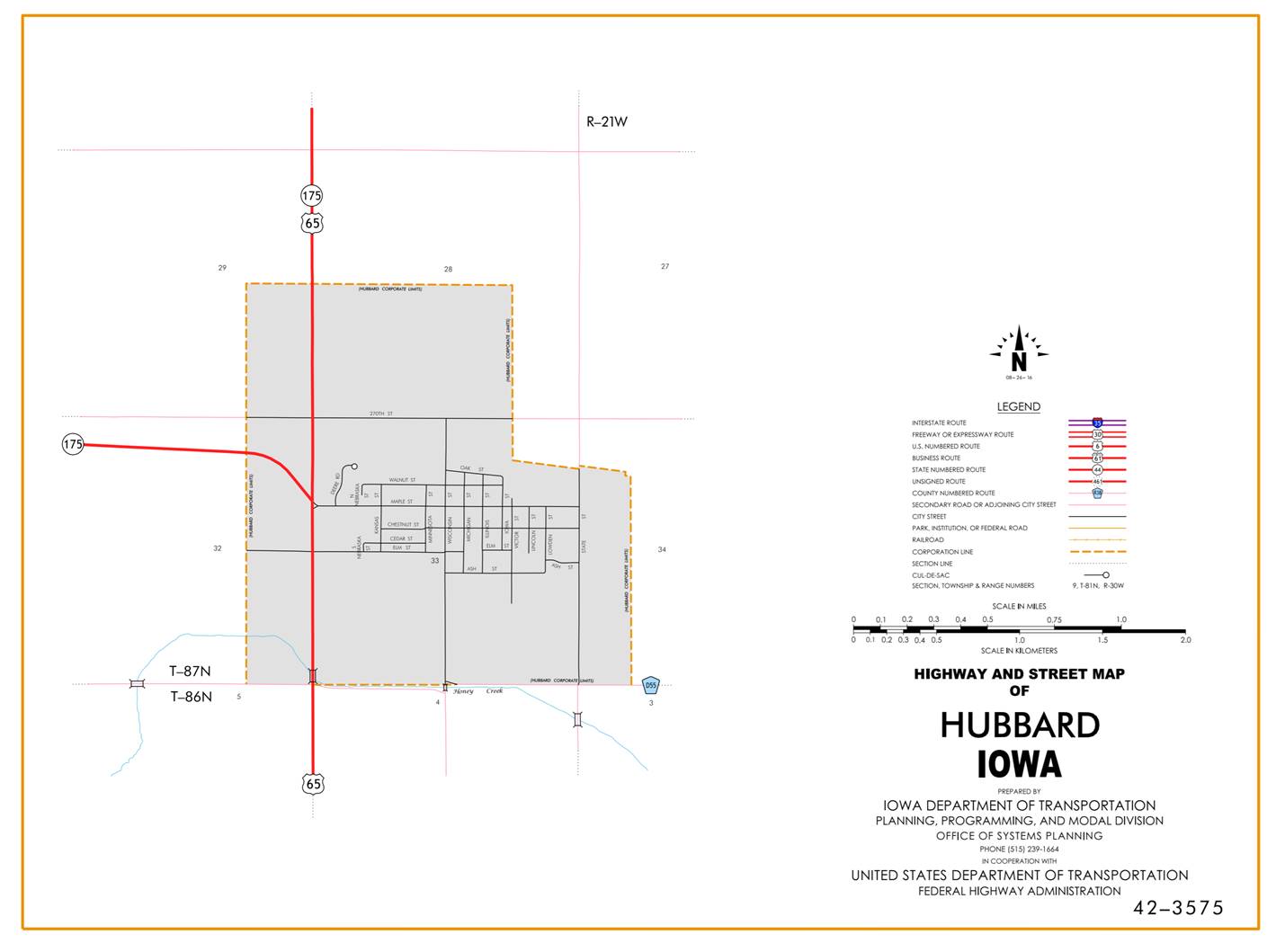
Hubbard:
Beginning at the south
corporation line; thence north (south junction of Iowa 175) to the north
corporation line.
Beginning
again on the north corporation line of Hubbard; thence north following
substantially the section line of Sections 29, 21, 16, and 9‑T87N‑R21W
to a point approximately 1,000 feet south of the W ¼ Corner of Section 9‑T87N-R21W;
thence curving in a northeasterly direction to a point approximately 1,000
feet east of the W ¼ Corner of Section 9‑T87N‑R21W; thence east
following substantially the center section line of Section 9, 10, and 11‑T87N‑R21W
to a point near the center of Section 11‑T87N-R21W (north junction Iowa
175); thence north following substantially the center section line of Section
11 and 2‑T87N‑R21W and 35, 26, 23, 14, 11(junction US 20), and 2‑T88N‑R21W
to a point approximately 400 feet south of the N ¼ Corner Section 2‑T88N‑R21W;
thence northwesterly through Section 2‑T88N-R21W and Section 31‑T89N‑R20W
to a point approximately 400 feet north of the SW Corner of Section 31‑T89N‑R20W;
thence north following substantially the section line of Section 31, and 30‑T89N‑R20W
to the south corporation line of Iowa Falls, connecting with Oak Street.
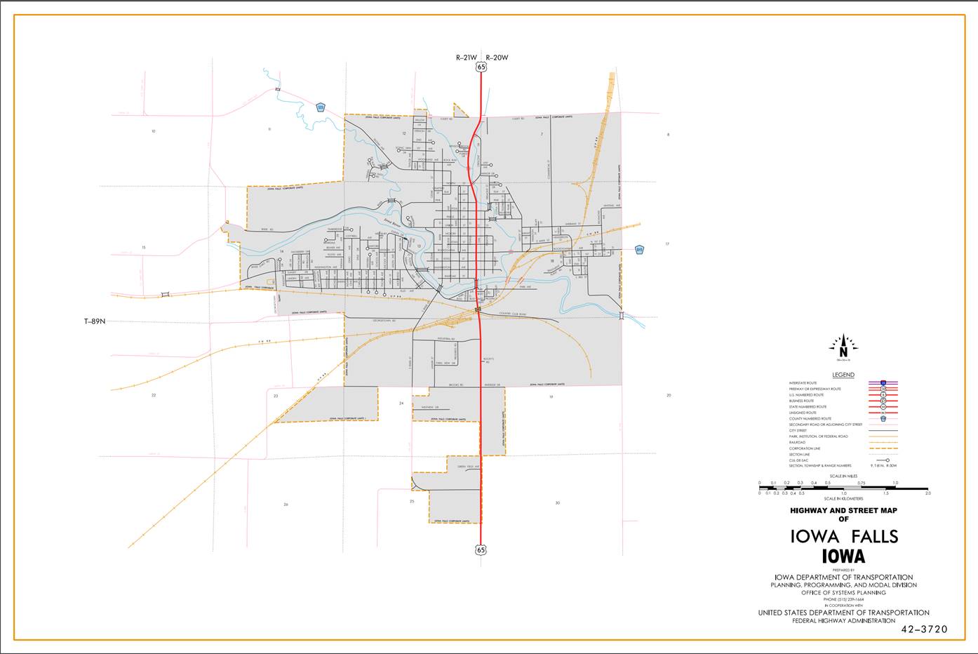
Iowa Falls:
Beginning on Oak Street at
the south corporation line; thence north, northwest, and northeast on Oak
Street to the north corporation line.
Beginning again on the
north corporation line of Iowa Falls, connecting with Oak Street; thence north
following substantially the section line of Section 7 and 6‑T89N‑R20W
to a point approximately 1,000 feet south of the NW Corner Section 6‑T89N‑R20W;
thence curving in a northeasterly direction to the Hardin‑Franklin County
line at a point approximately 1,000 feet east of the NW Corner Section 6‑T89N-R20W,
Hardin County (SW Corner Section 33‑T90N‑R20W; Franklin County);
thence east along the Hardin‑Franklin County line following substantially
the section line of Sections 6, 5, and 4‑T89N‑R20W to a point near
the NE Corner Section 4‑T89N‑R20W; Hardin County (SE Corner Section
33‑T89N‑R20W; Franklin County) (junction Iowa 57).
OFFICIAL DESCRIPTION
CHANGE
COUNTY: Hardin
ROUTE: US 65
STAFF
ACTION NUMBER: S-87-731
APPROVAL
DATE: 12-18-86
New
Description ‑ US 65 and its extensions in Hardin County
described as follows:
Beginning
on the Hardin‑Story County line at a point near the SW Corner Section 33‑T86N‑R21W,
Hardin County
(NW Corner Section 4‑T85N‑R21W, Story County);
thence north following substantially the section line of Sections 33, 28, 21,
16, 9, and 4‑T86N‑R21W to the south corporation line of Hubbard
connecting with an unnamed street.
Hubbard:
Beginning on an unnamed
street at the south corporation line; thence north on unnamed street to the
north corporation line.
Beginning
again on the north corporation line of Hubbard, connecting with an unnamed
street; thence north following substantially the section line of Sections 29,
21, 16, and 9‑T87N‑R21W to a point approximately 1,000 feet south
of the W ¼ Corner of Section 9‑T87N-R21W; thence curving in a
northeasterly direction to a point approximately 1,000 feet east of the W ¼
Corner of Section 9‑T87N‑R21W; thence east following substantially
the center section line of Section 9, 10, and 11‑T87N‑R21W to a
point near the center of Section 11‑T87N-R21W (north junction Iowa 175);
thence north following substantially the center section line of Section 11 and
2‑T87N‑R21W and 35, 26, 23, 14, 11, and 2‑T88N‑R21W to
a point approximately 400 feet south of the N ¼ Corner Section 2‑T88N‑R21W;
thence northwesterly through Section 2‑T88N-R21W and Section 31‑T89N‑R20W
to a point approximately 400 feet north of the SW Corner of Section 31‑T89N‑R20W;
thence north following substantially the section line of Section 31, 30, and
19‑T89N‑R20W to the south corporation line of Iowa Falls,
connecting with Oak Street.
Iowa Falls:
Beginning on Oak Street at
the south corporation line; thence north, northwest, and northeast on Oak
Street to the north corporation line.
Beginning again on the
north corporation line of Iowa Falls, connecting with Oak Street; thence north
following substantially the section line of Section 7 and 6‑T89N‑R20W
to a point approximately 1,000 feet south of the NW Corner Section 6‑T89N‑R20W;
thence curving in a northeasterly direction to the Hardin‑Franklin County
line at a point approximately 1,000 feet east of the NW Corner Section 6‑T89N-R20W,
Hardin County (SW Corner Section 33‑T90N‑R20W; Franklin County);
thence east along the Hardin‑Franklin County line following substantially
the section line of Sections 6, 5, and 4‑T89N‑R20W to a point near
the NE Corner Section 4‑T89N‑R20W; Hardin County (SE Corner Section
33‑T89N‑R20W; Franklin County) (north junction US 20).
COMMISSION
ORDER
DIVISION: Planning & Research
COMMISSION
ORDER NUMBER:
PR-79-272
SUBMITTED
BY: C.I. MacGillivray
MEETING
DATE:
11-2-78
DISCUSSION/BACKGROUND:
Due
to a review of our Primary Road Records, US 65 in Hardin County should be
deleted and the new description added should be officially included into the
Primary Road System.
US
65 begins at the Hardin‑Story County line, 6 miles south of Hubbard, and
travels in a northerly direction to the north junction of US 20 on
Hardin-Franklin County line, 4 ½ miles northeast of Iowa Falls, via the Cities
of Hubbard and Iowa Falls, Iowa.
PROPOSAL/ACTION
RECOMMENDATION:
Locate
US 65 and its extensions in Hardin
County as follows:
Beginning
on the Hardin‑Story County line at a point near the SW Corner Section 33‑T86N‑R21W,
Hardin County
(NW Corner Section 4‑T85N‑R21W, Story
County); thence northerly following
substantially the section line of Sections 33, 28, 21, 16, 9, and 4‑T86N‑R21W
to the south corporation line of the City of Hubbard,
Iowa
connecting with an unnamed street.
Hubbard:
Beginning
at the south corporation line, connecting with an unnamed street; thence
northerly to the north corporation line connecting with an unnamed street;
Beginning
again on the north corporation line of the City of Hubbard, connecting with an
unnamed street; thence northerly following substantially the section line of
Sections 28, 21, 16, and 9‑T78N‑R21W to a point approximately
1,000 feet south of the W ¼ Corner of Section 9‑T78N‑R21W; thence
curving in a northeasterly direction to a point approximately 1000 feet east of
the W ¼ Corner of Section 9‑T87N‑R21W; thence easterly following
substantially the center section line of Section 9, 10, and 11‑T87N‑R21W
to a point approximately 1,100 feet west of the center of Section 11‑T87N‑R21W,
(north junction Iowa 175); thence curving in a northeasterly direction to a
point approx. 1100 feet north of the center of Section 11‑T87N‑R21W;
thence northerly following substantially the center section line of Section 11
and 2‑T87N‑R21W and 35, 26, 23, 14, 11, and 2‑T88N‑R21W
to a point approximately 400 feet south of the N ¼ Corner Section 2-T83N-R21W;
thence northwesterly through Section 2‑T88N‑R21W and Section
31-T89N-R20W to a point approximately 400 feet north of the SW Corner of
Section 31T89N‑R20W; thence northerly following substantially the
section line of Section 31, 30, and 19‑T89N‑R20W to the south
corporation line of the City of Iowa Falls, connecting with an unnamed street.
Iowa Falls:
Beginning
at the south corporation line, connecting with an unnamed street; thence
northerly, northwesterly, northerly, northwesterly and northeasterly to the
north corporation line, connecting with an unnamed street.
Beginning
again on the north corporation line of the City of Iowa Falls, connecting with
an unnamed street; thence northerly following substantially the section line of
Section 7 and 6‑T89N‑R20W to a point approximately 1000 feet south
of the NW Corner Section 6‑T89N‑R20W; thence curving in a northeasterly
direction to the Hardin‑Franklin County line at a point approximately
1000 feet east of the NW Corner Section 6‑T89N‑R20W, Hardin County,
(SW Corner Section 33‑T90N‑R20W, Franklin County); thence easterly
along the Hardin‑Franklin County line following substantially the section
line of Section 6, 5 and 4‑T89N‑R20W to a point near the NE Corner
Section 4‑T89N‑R20W, Hardin County (SE Corner Section 33-T89N‑R20W,
Franklin County) (north junction US 20).
NOW,
THEREFORE: Be it resolved that the Iowa Department of Transportation approve
the location of US 65 in Hardin County, Iowa.
NOTE:
To become effective upon adoption of this resolution.
REVISED: 12-18-86
OFFICIAL
DESCRIPTION CHANGE
COUNTY: Hardin
APPROVAL
DATE: 12-31-68
Connecting
Curves.
Junction
of Iowa 175
and US 65:
Beginning
at a point approximately 1100 feet north of the center of Section 11‑T87N‑R21W;
thence south to a point approximately 900 feet north of the center of Section
11‑T87N‑R21W; thence curving in a southeasterly direction to a
point approximately 900 feet east of the center of Section 11‑T87N‑R21W.
OFFICIAL
DESCRIPTION CHANGE
COUNTY: Hardin
ROUTE: US 65
APPROVAL
DATE: 4-12-38
Beginning
on the Hardin‑Story County line at a point near the SW Corner of Section
33‑T86N‑R21W, Hardin County (NW Corner of Section 4‑T85N‑R21W,
Story County);
thence north following substantially the section line to the south corporation
line of the Town of Hubbard
connecting with an unnamed street.
Beginning
again on the north corporation line of the Town of Hubbard, connecting with an
unnamed street; thence north following substantially the section line to a point
approximately 1,000 feet south of the W ¼ Corner of Section 9‑T87N‑R21W;
thence curving in a northeasterly direction to a point approximately 1,000 feet
east of the W ¼ Corner of Section 9‑T87N‑R21W; thence east
following substantially the quarter section line to a point approximately 1,100
feet west of the center of Section 11‑T87N‑R21W; thence curving in
a northeasterly direction to a point approximately 1,100 feet north of the
center of Section 11-T87N‑R21W; thence north following substantially the
quarter section line to a point approximately 400 feet south of the N ¼ Corner
of Section 2‑T88N‑R21W; thence in a northwesterly direction to a
point approximately 400 feet north of the SW Corner of Section 31‑T89N‑R20W;
thence north following substantially the section line to the south corporation
line of the City of Iowa Falls, connecting with an unnamed street.
Beginning
again on the north corporation line of the City of Iowa Falls, connecting with
an unnamed street; thence north following substantially the section line to a
point approximately 1,000 feet south of the NW Corner of Section 6‑T89N‑R20W;
thence curving in a northeasterly direction to the Hardin‑Franklin
County line at a point approximately 1,000 feet east of the NW Corner of
Section 6‑T89N‑R20W, Hardin County (SW Corner of Section 31‑T90N‑R20W,
Franklin County); thence east along the Hardin‑Franklin County line to a
point approximately 1,000 feet west of the NE Corner of Section 4‑T89N‑R20W,
Hardin County (SE Corner of Section 33‑T90N‑R20W, Franklin County).
REVISED: 11-2-78