OFFICIAL
DESCRIPTION CHANGE
OFFICE:
Transportation Data
EFFECTIVE DATE: 08-22-2003
ENTERED
BY: Stefani Wonders
ENTERED
DATE: 01-07-2004
DISCUSSION/BACKGROUND:
New
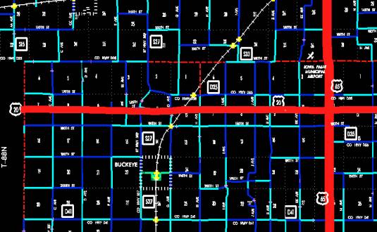
Description – US 20 and its extensions in Hardin County
described as follows:
Beginning on
the Hardin-Hamilton County line at a point near the W ¼ Corner Section
7-T88N-R22W, Hardin County (E ¼ Corner Section 12-T88N-R23W, Hamilton County);
thence west following substantially the center section line of Sections 7, 8,
9, 10, 11, and 12-T88N-R23W, Sections 7, 8, 9, 10, 11, and 12-T88N-R21W, and
Section 7-T88N-R20W to approximately the center of said Section 7; thence southeasterly
through Section 7, 8, 17-T88N-R20W to the north corporation line of Owasa (approximately 1330 feet south and 300 feet east of
the N ¼ Corner Section 17-T88N-R20W).
Owasa:
Beginning on
the north corporation line (approximately 1330 feet south and 300 feet east of
the N ¼ Corner Section 17-T88N-R20W); thence southeasterly to east corporation
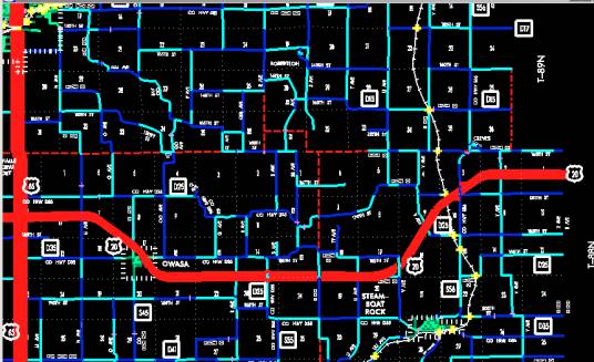
line (approximately 870 feet north of the SW Corner Section 16-T88N-R20W).
Beginning
again on the east corporation line of Owasa
(approximately 870 feet north of the SW Corner Section 16-T88N-R20W); thence southeasterly
through said Section 16 to approximately 2140 feet east of the SW Corner of
Section 16-T88N-R20W; thence easterly following substantially the south section
line of Sections 16, 15, 14, and 13-T88N-R20W, and Sections 18 and 17-T88N-R19W
to approximately 1730 feet east of the SW Corner of said Section 17; thence northeasterly
through Sections 17, 16, 9, 10, 3, and 2-T88N-R19W to approximately 360 feet
north and 900 feet east of the W ¼ Corner said Section 2; thence easterly
following substantially the center section line of Sections 2 and 1-T88N-R19W
to the Hardin-Grundy County line at a point near the E ¼ Corner Section
1-T88N-R19W, Hardin County (W ¼ Corner Section 6-T88N-R18W, Grundy County).
STAFF
ACTION
OFFICE: Transportation Inventory
STAFF ACTION NUMBER: S-93-639
SUBMITTED
BY: Patrick R. Cain
SUBMITTAL
DATE: 10-19-92
DISCUSSION/BACKGROUND:
Due to the
relocation of US 20 in Hardin County, the official description of this route
should be revised to reflect the new alignment.
The portion of new US 20 from the Hamilton-Hardin County
line eastward to the junction with US 65 was opened to traffic on October 7,
1991.
Beginning at
the Hamilton‑Hardin County line, US 20 extends eastward to junction with
US 65; thence north through Iowa Falls to the Franklin‑Hardin County line;
thence east through Ackley to the county lines of Butler
and Grundy Counties.
PROPOSAL/ACTION
RECOMMENDATION:
It is
recommended to approve revising the description of US 20 in Hardin County and
to include the attached new description in the Primary Road System.
New
Description ‑ US 20 and its extensions in Hardin County
described as follows:
Beginning on
the Hardin‑Hamilton county line at a point near the W ¼ Corner Section 7‑T88N‑R22W,
Hardin County (E ¼ Corner Section 12‑T88N‑R23W, Hamilton County);
thence east through Sections 7, 8, 9, 10, (Iowa 359 Interchange) 11 and 12‑T88N‑R22W
and Sections 7, 8, 9, 10 and 11‑T88N‑R21W, to a point near the W ¼
Corner SE ¼ of said Section 11 (south junction US 65); thence north
substantially following the center line of Sections 11 and 2‑T88N‑R21W
to a point approximately 400 feet south of the N ¼ Corner Sec 2‑T88N‑R21W;
thence northwesterly through Section 2‑T88N‑R21W and Section 31‑T89N‑R20W
to a point approximately 400 feet north of the SW Corner of Section 31‑T89N‑R20W;
thence north following substantially the section line of Section 31, 30, and 19‑T89N‑R20W
to the south corporation line of Iowa Falls, connecting with Oak Street.
Iowa Falls:
Beginning
on Oak Street
at the south corporation line; thence north, northwest, and northeast on Oak Street to the
north corporation line.
Beginning
again on the north corporation line of Iowa Falls, connecting with Oak Street;
thence north following substantially the section line of Section 7 and 6‑T89N‑R20W
to a point approximately 1,000 feet south of the NW Corner Section 6‑T89N‑R20W;
thence curving in a northeasterly direction to the Hardin‑Franklin County
line at a point approximately 1,000 feet east of the NW Corner Section 6‑T89N‑R20W,
Hardin County (SW Corner Section 33‑T90N-R20W, Franklin County); thence east
along the Hardin‑Franklin county line following substantially the section
line of Sections 6, 5, 4, (north junction US 65) 3, 2, and 1‑T89N‑R20W
and Section 6, 5, 4, and 3‑T89N‑R19W to the west corporation line
of Ackley, connecting with Sherman Avenue.
Ackley:
Beginning on
Sherman Avenue
on the Franklin‑Hardin county line at the west corporation line; thence east
on Sherman Avenue
to the east corporation line.
Beginning
again on the east corporation line of Ackley, connecting with Sherman Avenue;
thence east along the Hardin‑Franklin County line following substantially
the section line of Section 1‑T89N‑R19W to a point near the NE
Corner Section 1‑T89N‑R19W, Hardin County (SE Corner Section 36‑T90N-R19W,
Franklin County) (SW Corner Section 31‑T90N‑R81W, Butler County)
(NW Corner Section 6‑T89N‑R18W, Grundy County).
OFFICIAL
DESCRIPTION CHANGE
COUNTY:
Hardin
ROUTE:
US 20
STAFF
ACTION NUMBER: S-87-731
APPROVAL
DATE: 12-18-86
New
Description ‑ US 20 and its extensions in Hardin County
described as follows:
Beginning on
the Hardin‑Hamilton County line at a point near the NW Corner of Section
19‑T89N‑R22W, Hardin County (NE Corner of Section 24-T89N‑R23W,
Hamilton County); thence west following substantially the section line to a
point near the NE Corner Section 19‑T89N‑R22W; thence in an
westerly direction through the north part of Section 20 and 21‑T89N‑R22W
to a point near the N ¼ Corner of the NW ¼ Section 21‑T89N‑R22W;
thence westerly following substantially the section line of Section 21, 22, 23,
and 24‑T89N‑R22W to the west corporation line of Alden, connecting
with Grand Avenue.
Alden:
Beginning on
Grand Avenue
at the west corporation line; thence east on Grand Avenue to the west corporation
line.
Beginning
again on the east corporation line of Alden, connecting with Grand Avenue;
thence easterly following substantially the section line of Section 19 and 20‑T89N‑R21W
to a point approximately 900 feet east of the NW Corner Section 20‑T89N‑R21W;
thence in a northeasterly direction through the south part of Section 17‑T89N-R21W
to a point on the north side of the Chicago and Northwestern Railway
approximately 900 feet north of the SE Corner Section 17‑T89N-R21W;
thence in an easterly direction along the north side of said railroad and
substantially parallel thereto through Section 16, 15, and 14‑T89N‑R21W
to the west corporation line of Iowa
Falls connecting with Washington Avenue.
Iowa Falls:
Beginning
on Washington Avenue
at the west corporation line; thence east on Washington Avenue to Oak Street; thence north, northwest and
northeast on Oak Street
to the north corporation line.
Beginning
again at the north corporation line of Iowa Falls, connecting with Oak Street;
thence north following substantially the section line of Sections 7 and 6‑T89N‑R20W
to a point approximately 1,000 feet south of the NW Corner Section 6‑T89N‑R20W;
thence curving in a northeasterly direction to the Hardin‑Franklin County
line at a point approximately 1,000 feet east of the NW Corner Section 6‑T89N‑R20W;
Hardin County (SW Corner of Section 31‑T90N-R20W, Franklin County);
thence east along the Hardin-Franklin County line following substantially the
section line of Section 6, 5, 4, (north junction US 65) 3, 2, and 1‑T89N‑R20W
and Section 6, 5, 4, and 3‑T89N‑R19W to the west corporation line
of Ackley, connecting with Sherman Avenue.
COMMISSION
ORDER
DIVISION:
Planning & Research
COMMISSION
ORDER NUMBER:
PR-79-272
SUBMITTED
BY: C.I. MacGillivray
MEETING
DATE: 11-2-78
DISCUSSION/BACKGROUND:
Due to a
review of our primary highway records, US 20 in Hardin County should be deleted
from the Primary Road System and the new description added should be included
into the Primary Road System.
US 20 begins
at the Hardin‑Hamilton County line, 6 miles west of Alden, and travels in
an easterly direction to the Hardin‑Grundy County line 1½ miles east of
Ackley, via Cities of Alden, Iowa Falls, and Ackley, Iowa.
PROPOSAL/ACTION
RECOMMENDATION:
Locate US 20
and its extensions in Hardin
County as follows:
Beginning on
the Hardin‑Hamilton County line at a point near the NW Corner of Section
19‑T89N‑R22W, Hardin County (NE Corner of Section 24‑T89N‑R23W,
Hamilton County); thence easterly following substantially the section line to a
point near the NE Corner Section 19‑T89N‑R22W; thence in an
easterly direction through the north part of Section 20 and 21‑T89N‑R22W
to a point near the N ¼ Corner of the NW ¼ Section 21‑T89N‑R22W;
thence easterly following substantially the section line of Section 21, 22, 23,
and 24‑T89N‑R22W to the west corporation line of the City of Alden,
connecting with an unnamed street.
Alden:
Beginning on the west corporation
line connecting with an unnamed street; thence easterly to the east corporation
line, connecting with an unnamed street.
Beginning
again on the east corporation line of the City of Alden, connecting with an
unnamed street; thence easterly following substantially the section line of
Section 19 and 20‑T89N‑R21W to a point approximately 900 feet east
of the NW Corner Section 20‑T89N‑R21W; thence in a northeasterly
direction through the south part of Section 17‑T89N‑R21W, to a
point on the north side of the Chicago and Northwestern Railway approximately
800 feet north of the SE Corner Section 17‑T89N‑R21W; thence in an
easterly direction along the north side of said railroad and substantially
parallel thereto through Section 16, 15, and l4‑T89N‑R21W to the
west corporation line of the City of Iowa Falls connecting with an unnamed
street.
Iowa Falls:
Beginning
at the west corporation line, connecting with an unnamed street; thence
easterly, northerly, northwesterly and northeasterly to the north corporation
line, connecting with an unnamed street.
Beginning
again at the north corporation line of the City of Iowa Falls, connecting with
an unnamed street; thence northerly following substantially the section line of
Sections 7 and 6‑T89N‑R20W to a point approximately 1000 feet south
of the NW Corner Section 6‑T89N‑R20W; thence curving in a
northeasterly direction to the Hardin-Franklin County line at a point
approximately 1000 feet east of the NW Corner Section 6‑T89N‑R20W,
Hardin County, (SW Corner of Section 31‑T90N‑R20W, Franklin
County); thence easterly along the Hardin‑Franklin County line following
substantially the section line of Section 6, 5, 4, (north junction US 65) 3, 2,
and 1‑T89N‑R20W and Section (6, 5, 4, and 3-T89N-R19W to the west
corporation line of the City of Ackley, connecting with an unnamed street.
Ackley:
Beginning at the west corporation
line on the Hardin‑Franklin County line, connecting with an unnamed
street; thence easterly to the east corporation line on the Hardin‑Franklin
County line, connecting with an unnamed street.
Beginning
again on the east corporation line of the City of Ackley, connecting with an
unnamed street; thence easterly along the Hardin‑Franklin County line
following substantially the section line of Section 1‑T89N‑R19W to
a point near the NE Corner Section 1‑T89N‑R19W, Hardin County, (SE
Corner Section 36‑T90N-R19W, Franklin County) (SW Corner Section 31‑T90N‑R18W
Butler County) (NW Corner Section 6‑T89N‑R18W, Grundy County) (north
junction US 20).
NOW,
THEREFORE: Be it resolved that the Iowa Department of Transportation approve
the location of US 20 in Hardin County, Iowa.
NOTE: To
become effective upon adoption of this resolution.
REVISED: 12-18-86
OFFICIAL
DESCRIPTION CHANGE
COUNTY:
Hardin
ROUTE:
US 20
APPROVAL
DATE: 4-14-37
Beginning on
the Hardin‑Hamilton County line at a point near the NW Corner of Section
19‑T89N‑R22W, Hardin County, (NE Corner of Section 24-T89N‑R23W,
Hamilton County) thence east following substantially the section line to a
point near the NW Corner of Section 20‑T89N‑R22W; thence in an
easterly direction through the north part of Section 20‑T89N‑R22W,
to a point near the NE Corner of Section 20‑T89N‑R22W; thence east
following substantially the section line to the west corporation line of the
Town of Alden, connecting with Grand Avenue.
Beginning
again on the east corporation line of the Town of Alden, connecting with Grand
Avenue; thence east following substantially the section line to a point
approximately 900 feet east of the NW Corner of Section 20‑T89N‑R21W;
thence in a northeasterly direction through the south part of Section 17‑T89N‑R21W
to a point on the north side of the Chicago and Northwestern Railway
approximately 800 feet north of the SE Corner of Section 17‑T89N‑R21W;
thence in an easterly direction along the north side of said railroad and
substantially parallel thereto through Section 16 and 15‑T89N‑R21W
to a point approximately ¼ mile north of the SE Corner of Section 15‑T89N‑R21W;
thence in a northeasterly and easterly direction through Section 14‑T89N‑R21W
to the west corporation line of the City of Iowa Falls connecting with
Washington Avenue.
Beginning
again on the north corporation line of the City of Iowa Falls, connecting with
an unnamed street; thence north to a point approximately 1,000 feet south of
the NW Corner of Section 6‑T89N‑R20W; thence curving in a
northeasterly direction to the Hardin‑Franklin County line at a point
approximately 1,000 feet east of the NW Corner of Section 6‑T89N‑R20W
Hardin County, (SW Corner of Section 31‑T90N‑R20W, Franklin
County); thence east along the Hardin‑Franklin County line to the west
corporation line of the Town of Ackley connecting with Sherman Avenue.
Beginning
again on the east corporation line of the Town of Ackley connecting with Sherman
Avenue; thence east along the Hardin‑Franklin County line to a point near
the NE Corner of Section 1‑T89N‑R19W, Hardin County (SE Corner of
Section 36‑T90N‑R19W), Franklin County) (SW Corner of Section 31‑T90N‑R18W,
Butler County) (NW Corner of Section 6‑T89N‑R18W, Grundy County).
REVISED: 11-2-78