OFFICIAL
DESCRIPTION CHANGE
OFFICE: Research and Analytics
EFFECTIVE DATE: 11-21-2019
COUNTY: Fremont
ROUTE: US 59
ENTERED BY: Paul Mauer
ENTERED DATE: 11-21-2019
DISCUSSION/BACKGROUND:
Due
to a review of our Primary Road System records, US 59 in Fremont County should
be deleted, and the new description should be officially included into the
Primary Road System.
US
59 enters the corporation line of the city of Shenandoah.
New
Description:
US
59 and its extensions in Fremont County are described as follows.
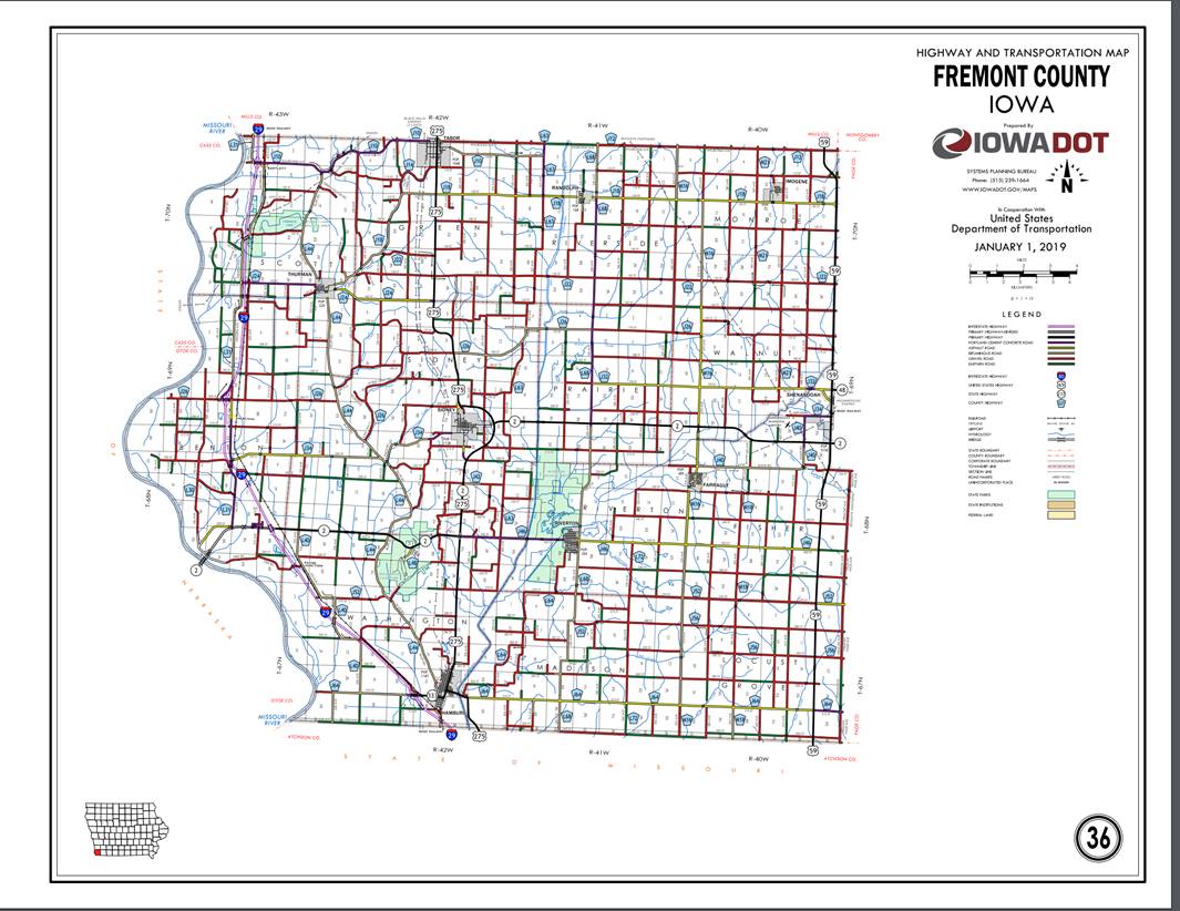
Beginning
on the Iowa‑Missouri State line, at a point approximately 900 feet south
of the NW Corner Section 36‑T67N‑R40W; thence north following
substantially the section line of Sections 36, 25, 24, 13, 12, and 1‑T67N‑R40W
and Sections 36, and 25-T68N-R40W to the south corporation line of Shenandoah
connecting with Fremont Street.
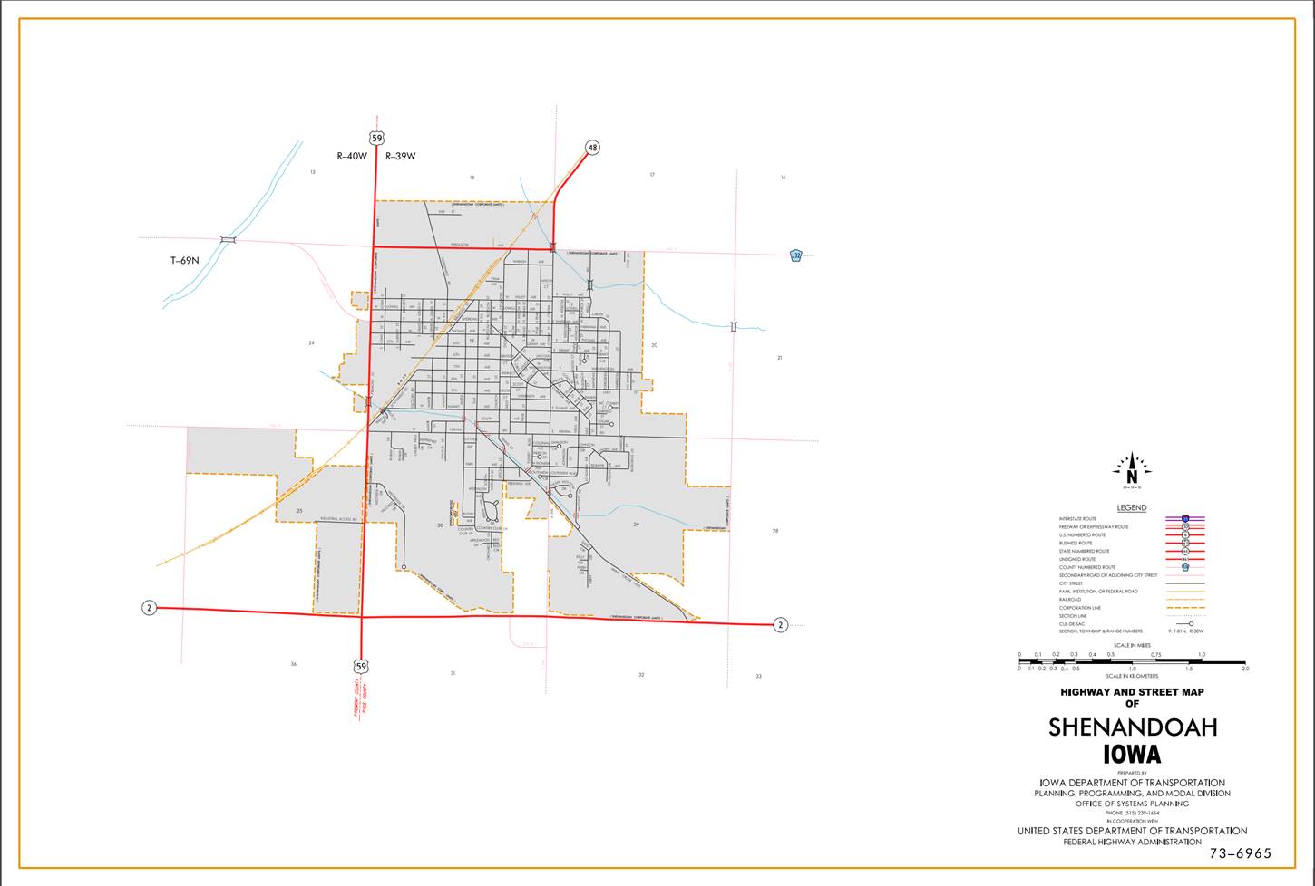
Shenandoah:
Beginning
at the south corporation line; continuing north on Fremont Street (junction
Iowa 48) to the north corporation line.
Beginning
again at the north corporation line of Shenandoah connecting with Fremont
Street; thence north along the Fremont-Page County line following substantially
the east section lines of Sections 13 and 12-T69N-R40W following substantially the east section lines
of Sections 25, 24,13 and 12-T70N-R40W to a point approximately 1000 feet south
of the NE Corner Section 12‑T70N‑R40W, Fremont County, (NW Corner
Section 7‑T70N-R39W Page County); thence in a northwesterly direction
through Sections 12 and 1-T70N‑R40W to a point approximately 2000 feet
south of the N ¼ Corner Section 1‑T70N‑R40W; thence north following
substantially the center section line of Section 1‑T70N‑R40W to the
Fremont‑Mills County line near the N ¼ Corner Section 1‑T70N‑R40W,
Fremont County (S ¼ Corner Section 36‑T71N‑R40W, Mills County).
COMMISSION ORDER
DIVISION: Planning & Research
COMMISSION
ORDER NUMBER:
PR-79-272
SUBMITTED
BY: C. I. MacGillivray
MEETING
DATE:
11-2-78
DISCUSSION/BACKGROUND:
Due
to a review of our Primary Road System records, US 59 in Fremont County should be deleted and the new
description should be officially included into the Primary Road System.
US
59 begins in the southeast corner of Fremont
County on the Iowa‑Missouri
State Line, travels northerly to the Fremont-Mills County Line approximately 3
miles northeast of Imogene.
PROPOSAL/ACTION
RECOMMENDATION:
Locate
US 59 in Fremont
County as follows:
Beginning
on the Iowa‑Missouri State line, at a point approximately 900 feet south
of the NW Corner Section 36‑T67N‑R40W; thence north following
substantially the section line of Sections 36, 25, 24, 13, 12, and 1‑T67N‑R40W
and Sections 36, 25, 24, 13, and 12‑T68N‑R40W to a point approximately
1000 feet north of the SW Corner Section 12‑T68N‑R40W; thence in a
northeasterly direction through Section 12‑T68N‑R40W and Section
36-T69N-R40W to a point on the Fremont‑Page County line approximately 600
feet south of the E ¼ Corner Section 36‑T69N‑R40W Fremont County (W
¼ Corner Section 31‑T69N‑R39W, Page County); thence north along the
Fremont‑Page County line (see Page County) to a point approximately 1000
feet south of the NE Corner Section 12‑T70N‑R40W, Fremont County,
(NW Corner Section 7‑T70N-R39W Page County); thence in a northwesterly
direction through Sections 12 and 1-T70N‑R40W to a point approximately
2000 feet south of the N ¼ Corner Section 1‑T70N‑R40W; thence north
following substantially the center section line of Section 1‑T70N‑R40W
to the Fremont‑Mills County line near the N ¼ Corner Section 1‑T70N‑R40W,
Fremont County (S ¼ Corner Section 36‑T71N‑R40W, Mills County).
NOW,
THEREFORE: Be it resolved that the Iowa Department of Transportation approve
the location of US 59 in Fremont County, Iowa.
NOTE: To become effective upon adoption of this
resolution.
OFFICIAL
DESCRIPTION CHANGE
COUNTY: Fremont
ROUTE: US 59
APPROVAL
DATE:
10-17-39
Beginning
on the Iowa-Missouri State line, at a point approximately 900 feet south of the
NW Corner Section 36‑T67N‑R40W; thence north following
substantially the section line to a point approximately 1000 feet north of the
SW Corner Section 12‑T68N‑R40W; thence in a northeasterly direction
through Section 12‑T68N‑R40W and Section 36‑T69N‑R40W
to a point approximately 600 feet south of the E ¼ Corner Section 36‑T69N‑R40W,
Fremont County, (W ¼ Corner Section 31‑T69N‑R39W, Page County);
thence north along the Fremont‑Page County line to a point approximately
1000 feet south of the NE Corner Section 12‑T70N‑R40W; thence in a
northwesterly direction through Section 12 and 1‑T70N‑R40W to a
point approximately 2000 feet south of the N ¼ Corner Section 1‑T70N‑R40W;
thence north following substantially the quarter line to the Fremont‑Mills
County line near the N ¼ Corner Section 1‑T70‑R40, Fremont County
(S ¼ Corner Section 36‑T71N‑R40W, Mills County).
REVISED: 11-2-78