OFFICIAL
DESCRIPTION CHANGE
OFFICE:
Transportation Data
EFFECTIVE
DATE: 09-2006
ENTERED
BY: Darlene Bovee
ENTERED
DATE: 09-14-2007
Due to the relocation at
New
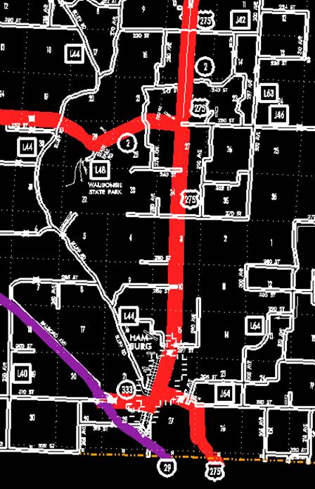
Description - US 275 and its extensions in
Beginning on
the Iowa-Missouri State line at a point approximately 700 feet south and 2130
feet east of the NW Corner Section 35-T67N-R42W; thence in a northwesterly and
northerly direction through Sections 35 and 26-T67N-R42W to a point near the NW
Corner Section 26-T67N-R42W then westerly 260 feet through Section
27-T67N-R42W; thence in a northwesterly direction through Section 22-T67N-R42W
to the east corporation line of Hamburg, connecting with "E" Street
(approximately 710 feet north and 2020 feet west of the SE Corner Section
22-T67N-R42W).
Beginning on
"E" Street at the east corporation line; thence northwesterly on
"F" Street to
Beginning
again on the north corporation line of Hamburg, connecting with Washington
Street; thence north following substantially the center section line of
Sections 15, 10, and 3-T67N-R42W and Section 34, 27 (south junction of Iowa 2),
22, 15, and 10-T68N-R42W to a point approximately 1800 feet south of the N ¼
Corner Section 10-T68N-R42W; thence in a northeasterly and northerly direction
through Section 10-T68N-R42W and Sections 35, 36 and 25-T69N-R42W to a point
approximately 1900 feet east and 2090 feet north of the SW Corner Section
25-T69N-R42W (north junction Iowa 2); thence northwesterly and westerly through
Sections 25, 26, and 23-T69N-R42W to a point approximately 700 feet east of the
SW Corner Section 23-T69N-R42W; thence northwesterly through Sections 23, 22,
15, and 10 -T69N-R42W to the NW Corner Section 10-T69N-R42W; thence northerly
on substantially the section line of Section 3, T69N, R42W and Sections 34, 27,
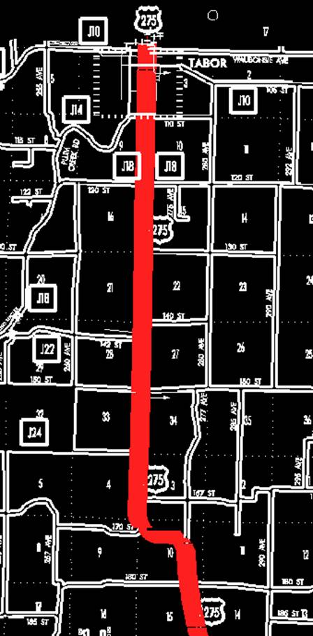
22, 15, and 10-T70N-R42W to the south corporation line of Tabor connecting with
Main Street (NW Corner Section 10-T70N-R42W).
Tabor:
Beginning at
the south corporation line connecting with
County).
OFFICIAL
DESCRIPTION CHANGE
COUNTY:
ROUTE:
US 275
STAFF
ACTION NUMBER: S-97-810
APPROVAL
DATE: 1-15-97
DISCUSSION/BACKGROUND:
Due to
relocation of US 275 in
PROPOSAL/ACTION
RECOMMENDATION:
It is
recommended the old description of US 275 in
New
Description - US 275 and its extensions in
Beginning on
the Iowa-Missouri State line at a point approximately 213 meters (700 feet)
south and 671 meters (2,200 feet) east of the NW Corner Section 35-T67N-R42W;
thence in a northwesterly and northerly direction through Section 35 and
26-T67N-R42W to a point near the NW Corner Section 26-T67N-R42W then westerly
80 meters (262 feet) through Section 27-T67N-R42W; thence in a northwesterly
and westerly direction through Section 22-T67N-R42W to the east corporation line
of Hamburg, connecting with "F" Street.
Beginning on
"F" Street at the east corporation line; thence northwesterly on
"F" Street to
Beginning again
on the north corporation line of Hamburg, connecting with Washington Street;
thence north following substantially the center section line of Sections 15,
10, and 3-T67N-R42W and Section 34, 27 (south junction of Iowa 2), 22, 15, and
10-T68N-R42W to a point approximately 152 meters (500 feet) south of the N ¼
Corner Section 10-T68N-R42W; thence in a northwesterly and northerly direction
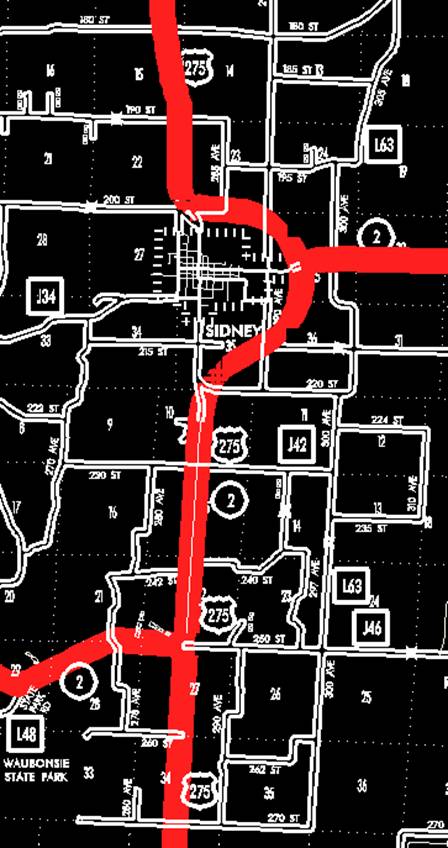
through Section 10-T68N-R42W and Section 35-T69N-R42W to the south corporation
line of Sidney, connecting with Main Street.
Beginning on
Beginning
again on the north corporation line of Sidney, connecting with Illinois Street;
thence in a northwesterly direction through Section 26 and 23-T69N-R42W to a
point approximately 381 meters (1,250 feet) north of the SW Corner
Sec.23-T69N-R42W; thence north following substantially the section line of
Sections 23 and 14-T69N-R42W to a point 274 meters (900 feet) north of the SW
Corner Section 14-T69N-R42W; thence in a northwesterly direction through
Sections 15, 10, and 3-T69N-R42W to a point approximately 61 meters (200 feet)
north of the SW Corner Section
3-T69N-R42W; thence north following substantially the section line of Section
3-T69N-R42W (junction Iowa 145) and Sections 34, 27, 22, 15 (junction of Iowa
184) and 10-T70N-R42W to the south corporation line of Tabor connecting with
Main Street.
Tabor:
Beginning at
the south corporation line connecting with Main Street; thence north on
OFFICIAL
DESCRIPTION CHANGE
COUNTY:
ROUTE:
US 275
STAFF
ACTION NUMBER: S-87-713
APPROVAL
DATE: 12-18-86
New
Description ‑ US 275 and its extensions in
Beginning on
the Iowa‑Missouri State line at a point approximately 700 feet south and
2,200 feet east of the NW Corner Section 35-T67N‑R42W; thence in a
northwesterly and northerly direction through Section 35 and 26‑T67N‑R42W
to a point near the NW Corner Section 26-T67N-R42W; thence in a northwesterly
and westerly direction through Section 22‑T67N‑R42W to the east
corporation line of Hamburg, connecting with "F" Street.
Beginning on
"F" Street at the east corporation line; thence northwesterly on
"F" Street to
Beginning again
on the north corporation line of Hamburg, connecting with Washington Street;
thence north following substantially the center section line of Sections 15,
10, and 3‑T67N‑R42W and Sections 34, 27 (south junction Iowa 2),
22, 15, and 10‑T68N‑R42W to a point approximately 500 feet south of
the N ¼ Corner Section 10‑T68N‑R42W; thence in a northwesterly and
northerly direction through Section 10‑T68N‑R42W and Section 35‑T69N‑R42W
to the south corporation line of Sidney, connecting with Main Street.
Beginning on
Beginning
again on the north corporation line of Sidney, connecting with Illinois
Street; thence in a northwesterly direction through Sections 26 and 23‑T69N‑R42W
to a point approximately 1,250 feet north of the SW Corner Section 23‑T69N‑R42W;
thence north following substantially the section line of Sections 23 and
14-T69N‑R42W to a point 900 feet north of the SW Corner Section 14-T69N‑R42W;
thence in a northwesterly direction through Sections 15, 10, and 3‑T69N‑R42W
to a point approximately 200 feet north of the SW Corner Section 3‑T69N‑R42W;
thence north following substantially the section line of Section 3‑T69N‑R42W
(junction Iowa 145) and Sections 34, 27, 22, 15 (junction of Iowa 184) and 10‑T70N‑R42W
to the south corporation line of Tabor connecting with Main Street.
Tabor:
Beginning at
the south corporation line connecting with Main Street; thence north on
COMMISSION
ORDER
DIVISION:
Planning & Research
COMMISSION
ORDER NUMBER:
PR-79-272
SUBMITTED
BY: C. I. MacGillivray
MEETING
DATE: 11-2-78
DISCUSSION/BACKGROUND:
Due to a
review of our Primary Road System records, US 275 in
US 275
begins at the Iowa‑Missouri State Line approximately 2 miles southeast of
Hamburg and travels in a northwesterly direction to the Fremont-Mills County
Line via the Cities of Hamburg, Sidney, and Tabor, Iowa.
PROPOSAL/ACTION
RECOMMENDATION:
Locate US
275 and its extensions in
Beginning on
the Iowa‑Missouri State Line at a point approximately 700 feet south and
2200 feet east of the NW Corner Section 35‑T67N‑R42W; thence in a
northwesterly and northerly direction through Section 35 and 26‑T67N‑R42W
to a point near the NW Corner Section 26‑T67N‑R42W; thence in a
northwesterly and westerly direction through Section 22-T67N‑R42W to the
east corporation line of the City of Hamburg, connecting with an unnamed
street.