OFFICIAL DESCRIPTION CHANGE
OFFICE: Transportation Data
EFFECTIVE DATE: 09-2006
ENTERED BY: Darlene Bovee
ENTERED DATE: 09-13-2007
New
Description ‑
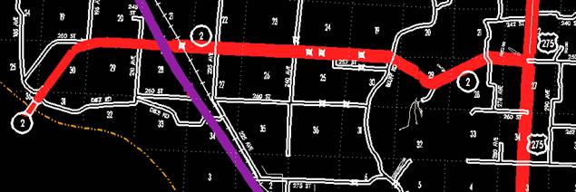
Beginning at
the Iowa‑Nebraska State line; thence northeasterly through Section
36-T68N‑R44W and Sections 31, 30 and 29‑T68N‑R43W to a point
approximately 900 feet east of the NW Corner Section 29-T68N-R43W; thence
easterly following substantially the section line of Sections 29 and 28
(junction of Interstate 29), 27, 26, 25‑T68N‑R43W and Section 30‑T68N‑R42W
to a point approximately 1100 feet west of the NE Corner of Section 30‑T68N‑R42W;
thence in a southeasterly direction through Sections 30 and 29‑T68N‑R42W
to a point approximately 1600 feet west of the E ¼ Corner of Section 29‑T68N‑R42W;
thence in a northeasterly direction through Sections 29, 28 and 21‑T68N‑R42W
to a point approximately 200 feet north and 1400 feet west of the SE Corner
Section 21-T68N-R42W; thence southeasterly through Sections 21 and 22-T68N-R42W
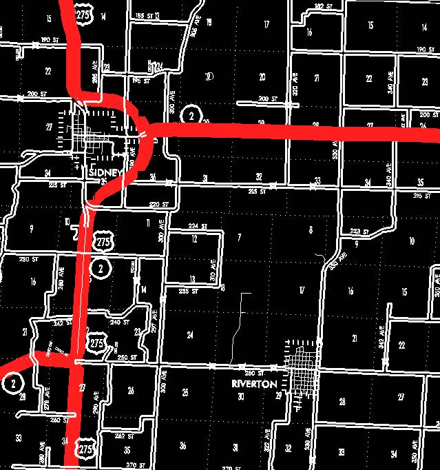
to the N ¼ Corner Section 27‑T68N‑R42W (south junction of US 275);
thence northerly following substantially the center section line of Sections
22, 15, and 10‑T68N‑R42W to a point approximately 1800 feet south
of the N ¼ Corner of Section 10-T68N-R42W; thence in a northeasterly and
northerly direction through Section 10-T68N-R42W and Sections 35, 36 and
25-T69N-R42W to a point approximately 1900 feet east and 2090 feet north of the
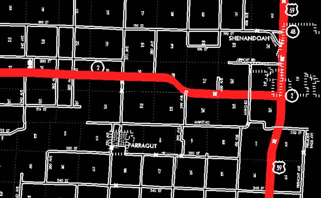
SW Corner Section 25-T69N-R42W (north junction of US 275); thence easterly
following substantially the center section line through Section 25‑T69N‑R42W
and Sections 30, 29, 28, 27, 26, and 25‑T69N‑R41W and Sections 30,
29, and 28-T69N-R40W to a point 1410 feet east of the W ¼ Corner of Section
28-T69N-R40W; thence in a southeasterly direction through Sections 28 and 27‑T69N‑R40W
to a point approximately 1018 feet west of the NE Corner of Section 34‑T69N‑R40W;
thence east following substantially the section line of Sections 34, 35, and 36‑T69N‑R40W
to the Fremont-Page County line, NE Corner Section 36‑T69N‑R40W,
Fremont County (NW Corner Section 31‑T69N‑R39W, Page County)
(junction of US 59).
OFFICIAL DESCRIPTION CHANGE
COUNTY:
ROUTE:
STAFF ACTION NUMBER: S-87-713
APPROVAL DATE: 12-18-86
New
Description ‑
Beginning at the Iowa‑Nebraska State line; thence northeasterly through Sections 36, 25‑T68N‑R44W and Section 30‑T68N‑R43W to a point near the N ¼ Corner of Section 30‑T68N‑R43W; thence east following substantially the section line of Sections 30, 29, 28 (junction of Interstate 29), 27, 26, 25‑T68N‑R43W and Section 30‑T68N‑R42W to a point approximately ¼ mile west of the NE Corner of Section 30‑T68N‑R42W; thence in a southeasterly direction through Sections 30 and 29‑T68N‑R42W to a point approximately ¼ mile west of the E ¼ Corner of Section 29‑T68N‑R42W; thence in a northeasterly direction through Sections 29 and 28‑T68N‑R42W to a point approximately 600 feet east of the N ¼ Corner of Section 28‑T68N‑R42W; thence in an easterly direction through the south part of Section 21‑T68N‑R42W to a point near the NW Corner Section 27‑T68N‑R42W; thence east following substantially the section line of Section 27-T68N‑R42W to a point near the N ¼ Corner of Section 27‑T68N‑R42W (south junction of US 275); thence north following substantially the center section line of Sections 22, 15, and 10‑T68N‑R42W to a point approximately 500 feet south of the N ¼ Corner of Section 10-T68N-R42W; thence in a northwesterly and northerly direction through Section 10‑T68N‑R42W and Section 35‑T69N‑R42W to the south corporation line of Sidney connecting with Main Street.
Beginning on
Main Street at the south corporation line; thence north on
Beginning again on the east corporation line of Sidney connecting with Filmore Street; thence in a northeasterly direction through Section 25‑T69N‑R42W to a point approximately 2,000 feet west of the E ¼ Corner of Section 25‑T69N‑R42W; thence east following substantially the center section line through Section 25‑T69N‑R42W and Sections 30, 29, 28, 27, 26, and 25‑T69N‑R41W and Sections 30, 29, and 28-T69N-R40W to a point 1,410 feet east of the W ¼ Corner of Section 28-T69N-R40W; thence curving in a southeasterly direction through Sections 28 and 27‑T69N‑R40W to a point approximately 1,018 feet west of the NE Corner of Section 34‑T69N‑R40W; thence east following substantially the section line of Sections 34, 35, and 36‑T69N‑R40W to the Fremont-Page County line, NE Corner Section 36‑T69N‑R40W, Fremont County (NW Corner Section 31‑T69N‑R39W, Page County) (junction of US 59).
STAFF ACTION
OFFICE: Transportation Inventory
STAFF ACTION NUMBER: S-83-781
SUBMITTED BY: Patrick R. Cain
SUBMITTAL DATE: 2-17-83
DISCUSSION/BACKGROUND:
The official
description for
PROPOSAL/ACTION RECOMMENDATION:
It is
recommended to approve deleting the present description of
Locate
Beginning at the Iowa‑Nebraska State line; thence northeasterly through Section 25‑T68N‑R44W and Section 30‑T68N‑R43W to a point near the N ¼ Corner of Section 30‑T68N‑R43W; thence east following substantially the section line of Sections 30, 29, 28 (junction of Interstate 29), 27, 26, 25‑T68N‑R43W and Section 30‑T68N‑R42W to a point approximately ¼ mile west of the NE Corner of Section 30‑T68N‑R42W; thence in a southeasterly direction through Sections 30 and 29‑T68N‑R42W to a point approximately ¼ mile west E ¼ Corner of Section 29‑T68N‑R42W; thence in a northeasterly direction through Sections 29 and 28‑T68N‑R42W to a point approximately 600 feet east of the N ¼ Corner of Section 28‑T68N‑R42W; thence in an easterly direction through the south part of Section 21‑T68N‑R42W to a point near the NW Corner Section 27‑T68N‑R42W; thence east following substantially the section line of Section 27‑T68N‑R42W to a point near the N ¼ Corner of Section 27‑T68N‑R42W (south junction of US 275); thence north following substantially the center section line of Sections 22, 15, and 10‑T68N‑R42W to a point approximately 500 feet south of the N ¼ Corner of Section 10‑T68N‑R42W; thence in a northwesterly and northerly direction through Section 10‑T68N‑R42W and Section 35‑T69N‑R42W to the south corporation line of the City of Sidney connecting with an unnamed street.
Beginning at the south corporation line connecting with an unnamed street; thence northerly, westerly, northerly, and easterly to the east corporation line connecting with an unnamed street.
Beginning again on the east corporation line of the City of Sidney connecting with an unnamed street; thence in a northeasterly direction through Section 25‑T69N‑R42W to a point approximately 2,000 feet west of the E ¼ Corner of Section 25‑T69N‑R42W; thence east following substantially the center section line through Section 25‑T69N‑R42W and Sections 30, 29, 28, 27, 26, and 25‑T69N‑R41W and Sections 30, 29, and 28‑T69N‑R40W to a point 1,410 feet east of the W ¼ Corner of Section 28‑T69N‑R40W; thence curving in a southeasterly direction through Sections 28 and 27‑T69N‑R40W to a point approximately 1,018 feet west of the NE Corner of Section 34-T69N‑R40W; thence east following substantially the section line of Sections 34, 35, and 36‑T69N‑R40W to the Fremont‑Page County line, NE Corner Section 36‑T69N‑R40W, Fremont County (NW Corner Section 31‑T69N‑R39W, Page County) (junction of US 59).
REVISED: 12-18-86
COMMISSION ORDER
DIVISION: Planning & Research
COMMISSION ORDER NUMBER: PR-79-272
SUBMITTED BY: C. I. MacGillivray
MEETING DATE: 11-2-78
DISCUSSION/BACKGROUND:
Due to a
review of our Primary Road System records,
PROPOSAL/ACTION RECOMMENDATION:
Locate
Beginning at the east end of the Missouri River Bridge in the north part of Section 36‑T68N‑R44W; thence in a northeasterly direction through Sections 36, 25‑T68N‑R44W and Section 30‑T68N‑R43W to a point near the N ¼ Corner of Section 30‑T68N‑R43W; thence east following substantially the section line of Sections 30, 29, 28 (junction of Interstate 29), 27, 26, 25‑T68N‑R43W and Section 30‑T68N‑R42W to a point approximately ¼ mile west of the NE Corner of Section 30‑T68N‑R42W; thence in a southeasterly direction through Sections 30 and 29‑T68N‑R42W to a point approximately ¼ mile west E ¼ Corner of Section 29‑T68N‑R42W; thence in a northeasterly direction through Sections 29 and 28‑T68N‑R42W to a point approximately 600 feet east of the N ¼ Corner of Section 28-T68N-R24W; thence in an easterly direction through the south part of Section 21‑T68N‑R42W to a point near the NW Corner Section 27‑T68N‑R42W; thence east following substantially the section line of Section 27‑T68N‑R42W to a point near the N ¼ Corner of Section 27‑T68N‑R42W (south junction of US 275); thence north following substantially the center section line of Sections 22, 15, and 10‑T68N‑R42W to a point approximately 500 feet south of the N ¼ Corner of Section 10‑T68N‑R42W; thence in a northwesterly and northerly direction through Section 10‑T68N‑R42W and Section 35‑T69N‑R42W to the south corporation line of the City of Sidney connecting with an unnamed street.
Beginning at the south corporation line connecting with an unnamed street; thence northerly, westerly, northerly, and easterly to the east corporation line connecting with an unnamed street.
Beginning again on the east corporation line of the City of Sidney connecting with an unnamed street; thence in a northeasterly direction through Section 25-T69N-R42W to a point approximately 2,000 feet west of the E ¼ Corner of Section 25-T69N‑R42W; thence east following substantially the center section line through Section 25‑T69N‑R42W and Sections 30, 29, 28, 27, 26, and 25-T69N-R41W and Sections 30, 29, and 28‑T69N‑R40W to a point 1410 feet east of the W ¼ Corner of Section 28‑T69N‑R40W; thence curving in a southeasterly direction through Sections 28 and 27‑T69N‑R40W to a point approximately 1018 feet west of the NE Corner of Section 34‑T69N‑R40W; thence east following substantially the section line of Sections 34, 35, and 36‑T69N‑R40W to the Fremont‑Page County line, NE Corner Section 36‑T69N‑R40W, Fremont County (NW Corner Section 31‑T69N‑R39W, Page County) (junction of US 59).
NOW,
THEREFORE: Be it resolved that the Iowa Department of Transportation approve
the location of
NOTE: To become effective upon the adoption of this resolution.
REVISED: 2-17-83
COMMISSION RESOLUTION
DIVISION: Planning & Research
COMMISSION ORDER NUMBER: 74-420
SUBMITTED BY: Gene R. Mills
MEETING DATE: 4-3-74
Locate
Beginning at the east end of the Missouri River Bridge in the south part of Section 25-T68N‑R44W; thence in a northeasterly direction through Section 25‑T68N‑R44W and Section 30‑T68N‑R43W to a point near the N ¼ Corner of Section 30‑T68N‑R43W; thence east following substantially the section line to a point approximately ¼ mile west of the NE Corner of Section 30‑T68N‑R42W; thence in a southeasterly direction through Sections 30 and 29‑T68N‑R42W to a point approximately ¼ mile west of the E ¼ Corner of Section 29‑T68N‑R42W; thence in a northeasterly direction through Sections 29 and 28‑T68N‑R42W to a point approximately 600 feet east of the N ¼ Corner of Section 28-T68N-R42W; thence in an easterly direction through the south part of Sections 21 and 22‑T68N‑R42W to a point near the S ¼ Corner of Section 22‑T68N‑R42W; thence north following substantially the quarter section line to a point approximately 500 feet south of the N ¼ Corner of Section 10‑T68N‑R42W; thence in a northwesterly and northerly direction through Section 10‑T68N‑R42W and Section 35‑T69N‑R42W to the south corporation line of the Town of Sidney connecting with Main Street.
Beginning again on the east corporation line of the Town of Sidney connecting with Filmore Street; thence in a northeasterly direction to a point approximately 2000 feet west of the E ¼ Corner of Section 25‑T69N‑R42W; thence east following substantially the quarter section line to a point approximately 1410 feet east of the W ¼ Corner of Section 28‑T69N‑R40W; thence curving in a southeasterly direction to a point approximately 1018 feet west of the NE Corner of Section 34‑T69N‑R40W; thence east following substantially the section line to the Fremont‑Page County line, NE Corner Section 36‑T69N‑R40W, Fremont County (NW Corner Section 31‑T69N‑R41W, Page County).
NOW,
THEREFORE: Be it resolved that the Iowa State Highway Commission approve the
location of
NOTE: To become effective upon adoption of this resolution.
OFFICIAL DESCRIPTION CHANGE
COUNTY:
ROUTE:
APPROVAL DATE: 4-3-74
Beginning at the east end of the Missouri River Bridge in the south part of Section 25-T68N‑R44W; thence in a northeasterly direction through Section 25‑T68N‑R44W and Section 30‑T68N‑R43W to a point near the N ¼ Corner of Section 30‑T68N‑R43W; thence east following substantially the section line to a point approximately ¼ mile west of the NE Corner of Section 30‑T68N‑R42W; thence in a southeasterly direction through Sections 30 and 29‑T68N‑R42W to a point approximately ¼ mile west of the E ¼ Corner of Section 29‑T68N‑R42W; thence in a northeasterly direction through Sections 29 and 28‑T68N‑R42W to a point approximately 600 feet east of the N ¼ Corner of Section 28‑T68N-R42W; thence in an easterly direction through the south part of Sections 21 and 22‑T68N‑R42W to a point near the S ¼ Corner of Section 22‑T68N‑R42W; thence north following substantially the quarter section line to a point approximately 500 feet south of the N ¼ Corner of Section 10‑T68N‑R42W; thence in a northwesterly and northerly direction through Section 10‑T68N‑R42W and Section 35‑T69N‑R42W to the south corporation line of the Town of Sidney connecting with Main Street.
Beginning again on the east corporation line of the Town of Sidney connecting with Filmore Street; thence in a northeasterly direction to a point approximately 2000 feet west of the E ¼ Corner of Section 25‑T69N‑R42W; thence east following substantially the quarter section line to a point approximately 1410 feet east of the W ¼ Corner of Section 28‑T69N‑R40W; thence curving in a southeasterly direction to a point approximately 1018 feet west of the NE Corner of Section 34‑T69N‑R40W; thence east following substantially the section line to the Fremont‑Page County line, NE Corner Section 36‑T69N‑R40W, Fremont County (NW Corner Section 31‑T69N‑R41W, Page County).
REVISED: 11-2-78
OFFICIAL DESCRIPTION CHANGE
COUNTY:
ROUTE:
APPROVAL DATE: 5-29-63
Beginning in the south part of Section 25‑T68N‑R44W at a point approximately 700 feet northeast of the east end of the Missouri River Bridge; thence on a northeasterly direction through Section 25‑T68N‑R44W and Section 30‑T68N‑R43W to a point near the N ¼ Corner of Section 30‑T68N‑R43W; thence east following substantially the section line to a point approximately ¼ mile west of the NE Corner of Section 30-T68N‑R42W; thence in a southeasterly direction through Sections 30 and 29‑T68N‑R42W to a point approximately ¼ mile west of the E ¼ Corner of Section 29‑T68N‑R42W; thence in a northeasterly direction through Sections 29 and 28‑T68N‑R42W to a point approximately 600 feet east of the N ¼ Corner of Section 28-T68NR42W; thence in an easterly direction through the south part of Sections 21 and 22‑T68N‑R42W to a point near the S ¼ Corner of Section 22-T68N-R42W; thence north following substantially the quarter section line to a point approximately 500 feet south of the N ¼ Corner of Section 10T68N‑R42W; thence in a northwesterly and northerly direction through Section 10‑T68N‑R42W and Section 35‑T69N‑R42W to the south corporation line of the Town of Sidney connecting with Main Street.
Beginning again on the east corporation line of the Town of Sidney connecting with Filmore Street; thence in a northeasterly direction to a point approximately 2000 feet west of the E ¼ Corner of Section 25-T69N‑R42W; thence east following substantially the quarter section line to a point approximately 1400 feet west of the E ¼ Corner of Section 28‑T69N‑R41W; thence curving in a northeasterly direction to a point approximately 1400 feet north of the E ¼ Corner of Section 28‑T69N‑R41W; thence north following substantially the section line to a point approximately 600 feet south of the NW Corner of Section 22‑T69N‑R41W; thence curving in a northeasterly direction to a point approximately 600 feet east of the NW Corner of Section 22‑T69N‑R41W; thence east following substantially the section line to a point near the N ¼ Corner of Section 24‑T69N‑R40W; thence in a southeasterly direction to the Fremont‑Page County line at a point approximately 500 feet north of the E ¼ Corner of Section 24‑T69N‑R40W; thence south along the Fremont-Page County line (W Corporation line of the City of Shenandoah) connecting with Nishna Road in the City of Shenandoah.
OFFICIAL DESCRIPTION CHANGE
COUNTY:
CITY OF:
ROUTE:
APPROVAL DATE: 2-5-36
Beginning on Main Street at the south corporation line; thence northerly on Main Street to Clay Street; thence westerly on Clay Street to Illinois Street; thence northerly on Illinois Street to Filmore Street; thence easterly on Filmore Street to the east corporation Line.
NOTE:
Revised from
REVISED: 11-3-41