OFFICIAL
DESCRIPTION CHANGE
OFFICE:
Transportation Data
EFFECTIVE
DATE: Summer 2005
ENTERED
BY: Darlene Bovee
ENTERED
DATE: 02-22-2008
New
Description - US 18 and its extensions in
Beginning
at the Floyd-Cerro Gordo County line, at a point near the W ¼ Corner SW ¼ of
Section 19-T96N-R18W, Floyd County (E ¼ Corner SE ¼ of Section 24-T96N-R19W,
Cerro Gordo County) thence easterly through Sections 19, 20, 21 and 22
T-96N-R18W to a point approximately 1900 feet east of the W ¼ Corner SW ¼ of
Section 22-T96N-R18W; thence northeasterly through Sections 22 and 23-T96N-R18W
to approximately the Center of Section 23-T96N-R18W; thence easterly through
Sections 23 and 24-T96N-R18W to west corporation line of Rudd connecting with
unnamed street (approximately the Center of Section 24-T96N-R18W).
Rudd:
Beginning
at the west corporation line connecting with unnamed street; thence easterly on
said unnamed street to the east corporation line (approximately 1940 feet south
and 1400 feet west of the NE Corner Section 19-T96N-R17W).
Beginning
again at the east corporation line of Rudd connecting with unnamed street;
thence northeasterly through Sections 19 and 20-T96N-R17W to near the N ¼
Corner Section 20-T96N-R17W; thence easterly following substantially the
section line of Sections 20, 21, 22, 23, and 24-T96N-R17W and Sections 19, 20,
and 21-T96N-R16W to the west corporation line of Floyd connecting with an
unnamed street (approximately 240 feet south and 1380 feet east of the NW
Corner Section 21-T96N-R16W).
Floyd:
Beginning
at the west corporation line connecting with unnamed street; thence
southeasterly on said unnamed street to the south corporation line (near the W
¼ Corner NE ¼ of Section 21-T96N-R16W) .
Beginning
at the south corporation line of Floyd connecting with unnamed street; thence
southeasterly through Sections 21 (north junction US 218), 22, 27, and
34-T96N-R16W and Section 3-T95N-R16W to approximately the N ¼ Corner of the SE
Corner of Section 3-T95N-R16W; thence southerly through Sections 3, 10 and
15-T95N-R16W to a point approximately 2470 feet north and 1600 feet west of the
SE Corner of Section 15-T95N-R16W; thence southeasterly through Sections 15 and
16-T95N-R16W to a point approximately 260 feet north and 650 east of the SW
Corner of Section 14-T95N-R16W; thence easterly through Sections 14 and
13-T95N-R16W to the west corporation line of Charles City connecting with South
Grand Avenue (approximately 210 feet north of the SW Corner of Section
18-T95N-R15W) .
Beginning
at the west corporation line connecting with South Grand Avenue (south junction
US 218); thence northerly and northwesterly on South Grand Avenue to Brantingham Street; thence northeasterly on Brantingham Street to 4th Avenue; thence
easterly and northeasterly on 4th Avenue to 5th Avenue; thence easterly on 5th
Avenue to east corporation line of Charles City (NW Corner of Section
8-T95N-R15W).
Beginning
again at the east corporation line of Charles City connecting with 5th Avenue;
thence easterly following substantially the section line of Sections 8, 9, 10,
11, and 12-T95N-R15W to the Floyd-Chickasaw County line at a point near the NE
Corner of Section 12-T95N-R15W, Floyd County (NW Corner Section 7-T95N-R14W,
Chickasaw County).
STAFF
ACTION
OFFICE:
Transportation Inventory
STAFF
ACTION NUMBER:
S-01-0584
SUBMITTED
BY: Patrick R. Cain
SUBMITTAL
DATE: 01-09-2001
DISCUSSION/BACKGROUND:
New
Description - US 18 and its extensions in Floyd County described as follows:
Beginning
at the Floyd-Cerro Gordo County line, at a point near the W ¼ Corner SW ¼ of
Section 19-T96N-R18W, Floyd County (E ¼ Corner SE ¼ of Section 24-T96N-R20W,
Cerro Gordo County) thence easterly through Sections 19, 20, and 21 T-96N-R18W
to a point approximately 1900 feet east of the W ¼ Corner SW ¼ of Section
22-T96N-R18W; thence northeasterly through Section 22-T96N-R18W to
approximately Center Section 23-T96N-R18W; thence easterly through Section 23
and 24-T96N-R18W to west corporation line of Rudd connecting with unnamed
street.
Rudd:
Beginning
at the west corporation line connecting with unnamed street; thence easterly on
said unnamed street to the east corporation line.
Beginning
again at the east corporation line of Rudd connecting with unnamed street;
thence in a northeasterly direction through Section 19-T96N-R17W to Center
Section 20-T96N-R17W; thence east following substantially the section line of
Sections 20, 21, 22, 23, and 24-T96N-R17W and Sections 19, 20, and 21-T96N-R16W
to the west corporation line of Floyd connecting with an unnamed street.
Floyd:
Beginning at the west corporation
line connecting with unnamed street; thence southeasterly on said unnamed street
to the south corporation line.
Beginning
at the south corporation line of Floyd connecting with unnamed street; thence
in a southeasterly direction through Sections 21 (north junction US 218), 22,
27, and 34-T96N-R16W and Section 3-T96N-R16W to approximately the Center SE ¼
Section 10-T96N-R16W; thence east through Sections 10 and 11-T96N-R16W to the
west corporation line of Charles City connecting with unnamed street.
Beginning
at the west corporation line on unnamed street; thence east on said unnamed
street to South Jackson Street; thence north on said unnamed street to Gilbert
Street; thence southeast on Gilbert Street to Brantingham Street; thence
northeasterly on Brantingham Street to 4th Avenue; thence easterly
and northeasterly on 4th Avenue to 5th Avenue; thence east on 5th
Avenue to east corporation line of Charles City.
Beginning
again at the east corporation line of
PROPOSAL/ACTION
RECOMMENDATION:
It
is recommended that the old description of US 18 and its extensions in
OFFICIAL
DESCRIPTION CHANGE
COUNTY: Floyd
ROUTE:
US 18
STAFF
ACTION NUMBER:
S-87-715
APPROVAL
DATE: 12-18-86
New
Description ‑ US 18 and its extensions in
Beginning on
Beginning
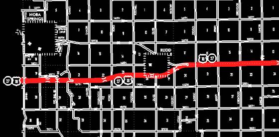
at the east corporation line of Nora Springs, connecting with Congress Street;
thence in an easterly and southeasterly direction through the south part of
Sections 8 and 9‑T96N‑R18W to a point near the S ¼ Corner of
Section 9‑T96N‑R18W; thence east following substantially the
section line of Sections 16, 15, and 14-T96N‑R18W to a point near the NE
Corner of Section 14‑T96N‑R18W; thence curving southeasterly
through the N ½ of Section 13‑T96N‑R18W to the north corporation
line of Rudd connecting with an unnamed street.
Rudd:
Beginning at the north corporation
line connecting with an unnamed street; thence southeasterly on said unnamed
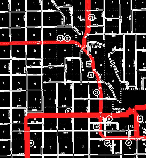
street to the east corporation line.
Beginning
again on the east corporation line of Rudd, connecting with an unnamed street
then southeasterly and curving easterly through the south part of Sections 18
and 17‑T96N‑R17W to a point approximately 475 feet east of the NW
Corner of Section 20‑T96N‑R17W; thence east following substantially
the section line of Sections 20, 21, 22, 23, and 24‑T96N‑R17W and
Sections 19, 20, and 21‑T96N‑R16W to the west corporation line of
Floyd connecting with an unnamed street.
Floyd:
Beginning at the west corporation
line connecting with an unnamed street; thence southeasterly on said unnamed
street to the south corporation line.
Beginning again at the south corporation line of Floyd
connecting with an unnamed street; thence in a southeasterly direction through
Sections 21 (north junction US 218), 22, 27, 34, and 35‑T96N‑R16W
and Section 2‑T95N‑R16W to the west corporation line of Charles
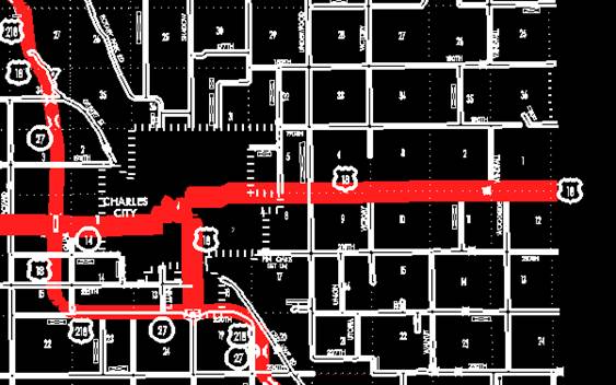
City connecting with Gilbert Street.
Beginning
on
Beginning
again at the east corporation line of Charles City connecting with 5th Avenue;
thence east following substantially the section line of Sections 8, 9, 10, 11,
and 12‑T95N‑R15W to the Floyd-Chickasaw County line at a point near
the NE Corner of Section 12-T95N-R15W, Floyd County (NW Corner of Section 7‑T95N‑R14W,
Chickasaw County).
COMMISSION
ORDER
DIVISION:
Planning & Research
COMMISSION
ORDER NUMBER:
PR-79-272
SUBMITTED
BY: C.I. MacGillivray
MEETING
DATE: 11-2-78
DISCUSSION/BACKGROUND:
Due
to a review of our Primary Road System records
US 18 begins at the Floyd‑Cerro Gordo County line
in Nora Springs and travels in a southeasterly direction via the Cities of Nora
Springs, Rudd, Floyd, and Charles City to the Floyd‑Chickasaw County line
approximately 5 miles east of Charles City, Iowa.
PROPOSAL/ACTION
RECOMMENDATION:
Locate
US 18 and its extensions in
Beginning
at the west corporation line on the Floyd‑Cerro Gordo County line; thence
easterly to the east corporation line connecting with an unnamed street.
Beginning
at the east corporation line of the City of Nora Springs, connecting with an
unnamed street; thence in an easterly and southeasterly direction through the
south part of Sections 8 and 9‑T96N‑R18W to a point near the south
quarter corner of Section 9‑T96N‑R18W; thence east following
substantially the section line of Sections 16, 15, and 14‑T96N‑R18W
to a point near the NE Corner of Section 14‑T96N‑R18W; thence
curving southeasterly through the N ½ of Section 13‑T96N‑R18W to
the north corporation line of the City of Rudd connecting with an unnamed
street.
Rudd:
Beginning at the north corporation
line connecting with an unnamed street; thence southeasterly to the east
corporation line.
Beginning
again on the east corporation line of the City of Rudd, connecting with an
unnamed street; thence southeasterly and curving easterly through the south
part of Sections 18 and 17‑T96N‑R17W to a point approximately 475
feet east of the NW Corner of Section 20‑T96N‑R17W; thence east
following substantially the section line of Sections 19, 20, 21, 22, 23, and 24‑T96N‑R17W
and Sections 19, 20, and 21‑T96N‑R16W to the west corporation line
of the City of Floyd connecting with an unnamed street.
Floyd:
Beginning at the west corporation
line connecting with an unnamed street; thence southeasterly to the south
corporation line connecting with an unnamed street.
Beginning
again at the south corporation line of the City of Floyd connecting with an
unnamed street; thence in a southeasterly direction through Sections 21 (north
junction US 218), 22, 27, 34, and 35-T96N‑R16W and Section 2‑T95N‑R16W
to the west corporation line of the City of Charles City connecting with an
unnamed street.
Beginning at the west corporation
line connecting with an unnamed street; thence southeasterly, easterly, northerly,
and easterly to the east corporation line connecting with an unnamed street.
Beginning
again at the east corporation line of the City of Charles City connecting with
an unnamed street; thence east following substantially the section line of Sections
8, 9, 10, 11, and 12‑T95N‑R15W to the Floyd-Chickasaw County line
at a point near the NE Corner of Section 12‑T95N‑R18W, Floyd County
(NW Corner of Section 7‑T95-R14W, Chickasaw County).
NOW,
THEREFORE: Be it resolved that the Iowa Department of Transportation approve
the location of US 18 in Floyd County,
NOTE:
To become effective upon the adoption of this resolution.
REVISED:
12-18-86
COMMISSION
RESOLUTION
DIVISION:
Planning & Research
COMMISSION
ORDER NUMBER:
68-1406
SUBMITTED
BY: Raymond L. Kassel
MEETING
DATE: 10-16-68
Locate
US 18 in Floyd County as follows:
Beginning
on the east corporation line of the Town of Nora Springs connecting with
Congress Street; thence in an easterly and southeasterly direction through the
south part of Section 8 and 9‑T96N‑R18W to a point near the south
quarter corner of Section 9-T96N‑R18W; thence east following
substantially the section line to a point near the NW Corner Section 13-T96N‑R18W;
thence curving southeasterly, and continuing southeasterly through the N ½ of
Section 13‑T96N‑R18W to the north corporation line of the Town of
Rudd connecting with an unnamed street at a point approximately 250 feet west
of the E ¼ Corner Section 13‑T96N‑R18W.
Beginning
again on the south corporation line of the Town of Floyd, connecting with an
unnamed street at a point approximately 1000 feet south and 100 feet west of
the N ¼ Corner Section 21-T96N-R16W; thence in a southeasterly direction
through Sections 21, 22, 27, 34 and 35‑T96N‑R16W, and Section 2‑T95N‑R16W
to the west corporation line of the City of Charles City, connecting with
Gilbert Street.
NOW
THEREFORE: Be it resolved that the Iowa State Highway Commission approve the
revision of the above Primary Road Description.
NOTE:
To become effective upon adoption of this resolution.
The old location of US 18 from Sta. 499+ 23.6 to Sta.
545+35 and from Sta. 181+75 to Sta. 167+20 will revert to the Floyd County
Secondary Road System in accord with Section 313.2 Code of Iowa.
OFFICIAL
DESCRIPTION CHANGE
COUNTY:
Floyd
ROUTE:
US 18
COMMISSION
ORDER NUMBER:
APPROVAL
DATE: 10-16-68
Beginning
on the east corporation line of the Town of Nora Springs, connecting with
Congress Street; thence in an easterly and southeasterly direction through the
south part of Section 8 and 9‑T96N‑R18W to a point near the south
quarter corner of Section 9‑T96N‑R18W; thence east following
substantially the section line to a point near the NW Corner Section 13-T96N-R18W;
thence curving southeasterly, and continuing southeasterly through the N ½ of
Section 13‑T96N‑R18W to the north corporation line of the Town of
Rudd connecting with an unnamed street.
Beginning
again on the east corporation line of the Town of
Beginning again on the south
corporation line of the Town of
Beginning again on the east
corporation line of the City of Charles City connecting with
COMMISSION
RESOLUTION
DIVISION:
Planning & Research
COMMISSION
ORDER NUMBER:
67-1761
SUBMITTED
BY: Raymond L. Kassel
MEETING
DATE: 12-6-67
Locate US 18 in Charles City, Floyd County, Iowa, on the
streets and roads as follows:
Beginning
on
NOW,
THEREFORE: Be it resolved that the Iowa State Highway Commission approve the
revision of the above Primary Road Description.
NOTE: To become effective upon adoption of this
resolution.
OFFICIAL
DESCRIPTION CHANGE
COUNTY:
Floyd
CITY
OF: Rudd
ROUTE:
US 18
APPROVAL
DATE: 3-9-60
Commencing on an unnamed street at
the north corporation line; thence southeasterly on unnamed street to the east
corporation line.
OFFICIAL
DESCRIPTION CHANGE
COUNTY:
Floyd
CITY
OF:
ROUTE:
US 18
APPROVAL
DATE: 10-19-55
Commencing on the extension of
OFFICIAL
DESCRIPTION CHANGE
COUNTY:
FLOYD
COMMISSION
ORDER NUMBER:
APPROVAL
DATE: 4-14-37
CONNECTING
CURVES
Junction
of US 18 and US 218, south of Floyd:
Beginning
at a point approximately 2300 feet south and 1600 feet west of the NE Corner of
Section 21‑T96‑R16; thence curving in a northeasterly direction to
a point approximately 2100 feet south and 1200 feet west of the NE Corner of
Section 21-T96‑R16.
OFFICIAL
DESCRIPTION CHANGE
COUNTY:
Floyd
CITY
OF: Floyd
ROUTE:
US 18
APPROVAL
DATE: 2-5-36
Commencing on unnamed street at the
west corporation line; thence southeasterly on unnamed street to the south
corporation line.
OFFICIAL
DESCRIPTION CHANGE
COUNTY: Floyd
CITY
OF:
ROUTE:
US 18
Beginning
on Gilbert Street at the west corporation line thence southeasterly on Gilbert
Street to Second Street; thence easterly on Second Street to Freeman Street;
thence northerly on Freeman Street to Brantingham Street; thence northeasterly
on Brantingham Street to Kelly Street; thence northeasterly and easterly on
Fourth Avenue to "G" Street; thence northeasterly on unnamed street
to Fifth Avenue; thence easterly an Fifth Avenue to the east corporation line.