OFFICIAL DESCRIPTION CHANGE
OFFICE: Research and Analytics
EFFECTIVE DATE: 09-01-2020
COUNTY: Dubuque
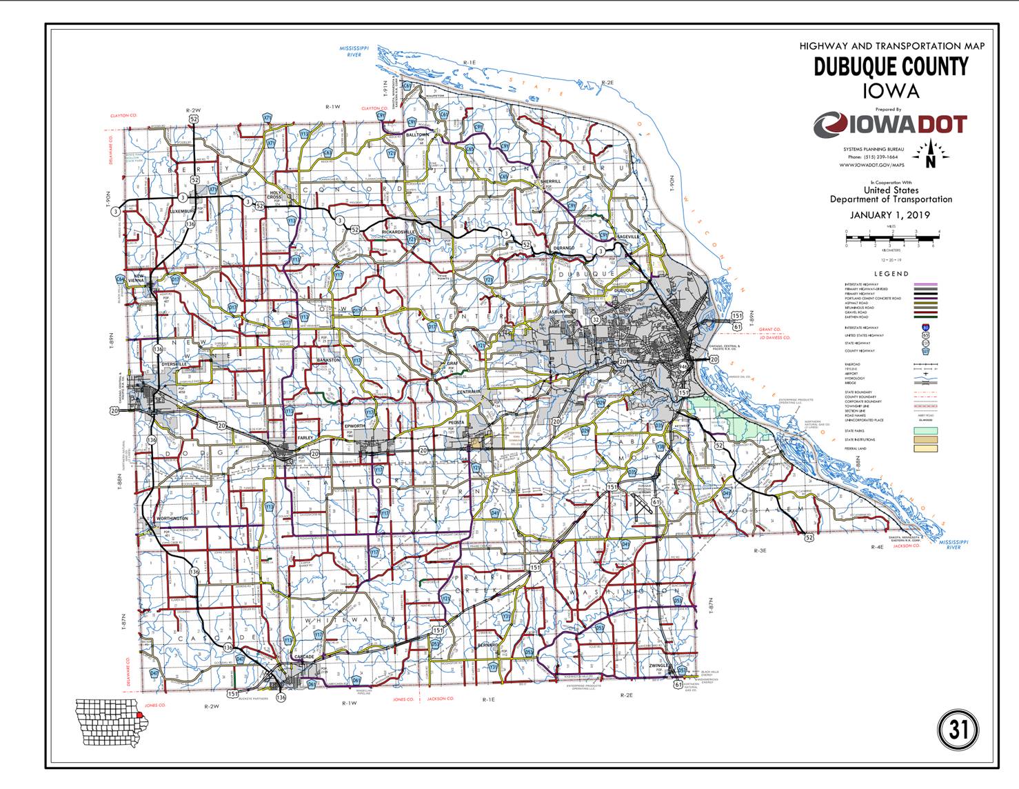
ROUTE: US 52
ENTERED BY: Paul Mauer
ENTERED DATE: 08-14-2020

New
Description - US 52 and its extensions in Dubuque County
described as follows:
Beginning
on the Dubuque-Jackson County line at a point approximately 1,700 feet west of
the SE Corner of Section 35-T88N-R3E, Dubuque County (NE Corner of Section
2-T87N-R3E, Jackson County); thence in a northwesterly direction through
Sections 35, 34, 27, 28, 21, 20, 21, 16, 17, 8, 7 and 6-T88N-R3E, and in a
northwesterly direction in Section 1-T88N-R2E to a point approximately ¼ mile
north of 0.4 mile west of the SE Corner of Section 1-T88N-R2E (south junction
US 61 and US 151); thence southeast through Section 1-T88N-R02E to the north
corporation line of the City of Dubuque.
Dubuque:
Beginning
at the north corporation line; then southeast and south then northwest on SW
Arterial to the west corporation line.
Beginning
again at the west corporation line of the city of Dubuque; thence northwesterly
through Sections 14, 11, 2, 3, 4 and 5-T88N-R02E; thence northwest through
Section 32-T89N-R02E to the east corporation line of Dubuque.
Dubuque:
Beginning
at the east corporation then northwest connecting with US 20; then
southwesterly to the south corporation line.
Beginning
again at the south corporation line of Dubuque; thence southwesterly through
Sections 6 and 7-T88N-R02E; continuing southwest through Section 12-T88N-R01E;
then west following substantially the section line of Sections 13, 14, and 15‑T88N‑R1E;
thence continuing west through the south part of Section 12‑T88N‑R1W
and Sections 7, 8, 9, and 10‑T88N‑R01E; thence continuing in an
westerly direction through Sections 13, and 14‑T88N‑R01W to the
east corporation line of Epworth.
Epworth:
Beginning at the east
corporation line; thence east to the west corporation line.
Beginning again at the
east corporation line of Epworth; thence west through Section 14-T88N-R1W to
the east corporation line of Epworth.
Epworth:
Beginning at the east
corporation line; thence west and northwesterly to the west corporation line.
Beginning again at the
west corporation line of Epworth; thence west following substantially the
section line of Sections 15, 16 and 17-T88N-R01W to the east corporation line
of Farley.
Farley:
Beginning
at the east corporation line; thence northwesterly, westerly, and northwesterly
to the west corporation line.
Beginning
again at the west corporation line of Farley; thence northwest along the south
side of the Illinois Central Railroad and substantially parallel thereto
through Sections 12,11, 2, 3‑T88N‑R02W; thence northwest and west through
Sections 4 and 5-‑T88N‑R02W to the east corporation line of
Dyersville.
Dyersville:
Beginning
at the east corporation line, then west to the junction of Iowa 136, then north
connecting with Iowa 136, then northeast and north to the north corporation
line of Dyersville.
Beginning again on the north corporation line of Dyersville;
thence in a northerly direction through the west part of Sections 29, 20, 17,
and 8‑T89N‑R2W to the south corporation line of New Vienna
connecting with Columbus Street.
New Vienna:
Beginning on Columbus Street at the south corporation line;
thence northwest and north on Columbus Street to the north corporation
line.
Beginning again on the north corporation line of the City
of New Vienna connecting with Columbus Street; thence northeasterly
through Section 5‑T89N‑R2W and Sections 32, 33, 28, 21, and 22‑T90N‑R2W
to the south corporation line of the City of Luxemburg connecting with
William Andre Street.
Luxemburg:
Beginning on William Andre Street at the south corporation
line; thence north through the junction of Iowa 3 to the north corporation
line.
Beginning
again on the north corporation line of Luxemburg connecting with William Andre
Street; thence north following substantially the section line of Sections 15,
10, and 3-T90N-R02W to the Dubuque-Clayton County line at a point near the NW
Corner of Section 3-T90N-R02W, Dubuque County (SW Corner of Section
34-T91N-R2W, Clayton County).
OFFICE: Research
and Analytics
EFFECTIVE
DATE: 6-14-2019
COUNTY: Dubuque
ROUTE: US
52
ENTERED BY: Paul
Mauer
ENTERED
DATE: 1-31-2020
New
Description - US 52 and its extensions in Dubuque County
described as follows:
Beginning
on the Dubuque-Jackson County line at a point approximately 1,700 feet west of
the SE Corner of Section 35-T88N-R3E, Dubuque County (NE Corner of Section
2-T87N-R3E, Jackson County); thence in a northwesterly direction through
Sections 35, 34, 27, 28, 21, 20, 21, 16, 17, 8, 7 and 6-T88N-R3E, and in a northwesterly
direction in Section 1-T88N-R2E to a point approximately ¼ mile north of 0.4
mile west of the SE Corner of Section 1-T88N-R2E (south junction US 61 and US
151); thence southeast through Section 1-T88N-R02E to the north corporation
line of the City of Dubuque.
Dubuque:
Beginning
at the north corporation line; then southeast and south to the south
corporation line.
New
Description - US 52 and its extensions in Dubuque
County
described as follows:
Beginning on the
Dubuque-Jackson County line at a point approximately 1,700 feet west of the SE
Corner of Section 35-T88N-R3E, Dubuque County (NE Corner of Section 2-T87N-R3E,
Jackson County); thence in a northwesterly direction through Sections 35, 34,
27, 28, 21, 20, 21, 16, 17, 8, 7 and 6-T88N-R3E, and in a northwesterly
direction in Section 1-T88N-R2E to a point approximately ¼ mile north of 0.4
mile west of the SE Corner of Section 1-T88N-R2E (south junction US 61 and US
151); thence
in a northeasterly and northerly direction through Section 1-T88N-R2E to the
south corporation line of Dubuque connecting with Kerrigan Road.
Dubuque:
Beginning on Kerrigan Road
at the south corporation line; thence north on Kerrigan Road to South Locust
Street; thence northeast and north on unnamed street to 9th and 11th Street off
ramp; thence northeast on off ramp (begin one-way northbound) to 11th Street;
thence southwesterly on 11th Street to White Street; thence northwesterly on
White Street to 21st Street; thence southwesterly on 21st Street to Central Avenue
(end one-way northbound); thence northwesterly on Central Avenue to the north
corporation line.
Also
Beginning on Central Avenue at an
intersection with 21st Street
(begin one-way southbound); thence southeasterly on Central Avenue to East 9th Street; thence
northwesterly on East 9th Street
to southbound onramp; thence southbound to unnamed street (end one-way
southbound).
Beginning
on the north corporation line of Dubuque connecting with Central Avenue; thence
in a northwesterly direction through Sections 11-T89N-R2E to the south
corporation line of Sageville.
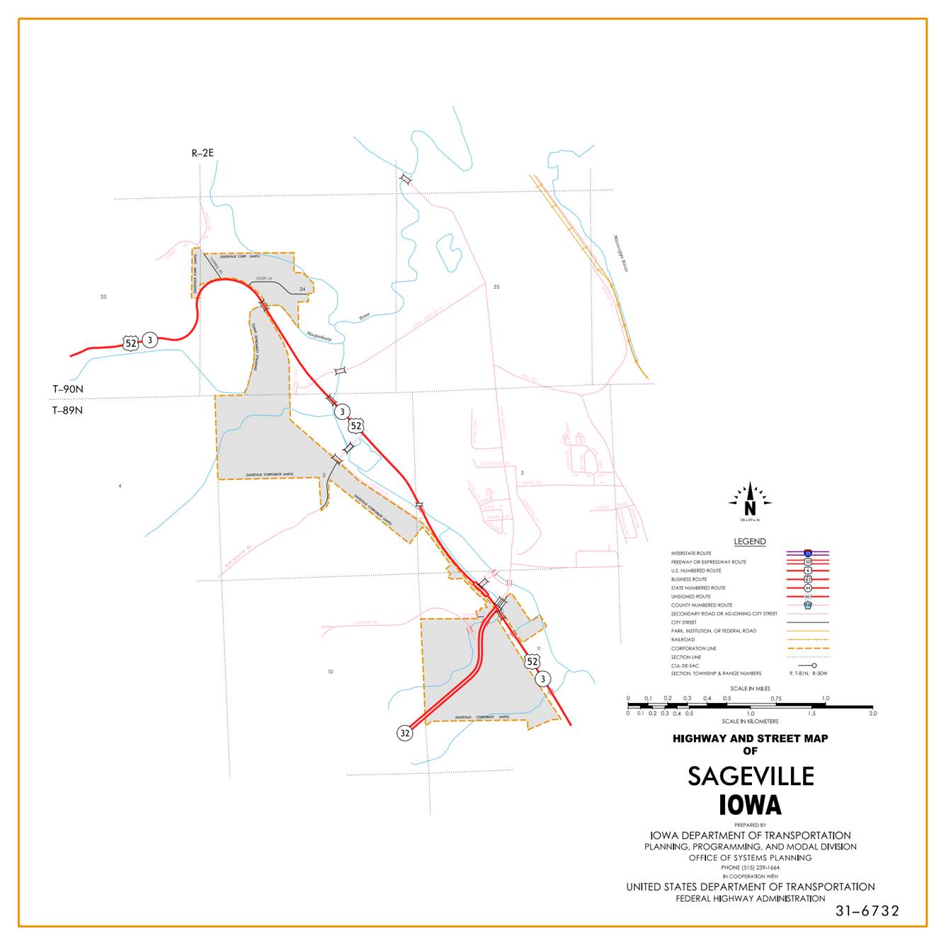
Sageville:
Beginning
at the south corporation line then northwesterly to the north corporation line.
Beginning
again at north corporation line of Sageville; thence
in a northwesterly direction through Sections 11, 2 and 3-T89N-R2E, in a
northwesterly and southwesterly direction through Section 34-T90N-R2E to the
east corporation line of Sageville.
Sageville:
Beginning
at the east corporation line, then southwesterly to the south corporation line.
Beginning
again at the south corporation line of Sageville;
thence southwesterly through Section 33-T90N-R2E, and Sections 4 and 5-T89N-R2E
to a point approximately 700 feet south and 700 feet west of the NE Corner of
Section 5-T89N-R2E; thence in a northwesterly and westerly direction through
Section 5-T89N-R2E and Sections 32 and 31-T90N-R2E to the east corporation line
of Durango.
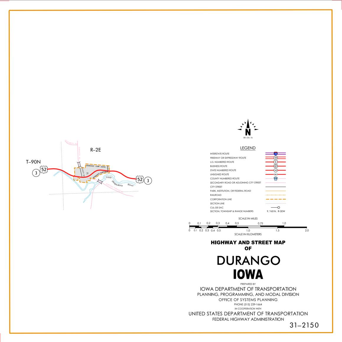
Durango:
Beginning at the east
corporation line; thence westerly, southwesterly, and westerly to the west
corporation line.
Beginning
again on the west corporation line of Durango; thence in a northwesterly
direction through Section 31-T90N-R2E and Sections 36, 35, 26, 27 and 28-T90N-R1E
to the east corporation line of Rickardsville
connecting with Main Street.
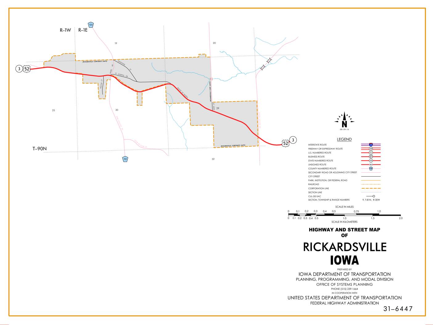
Rickardsville:
Beginning on Main Street at the
east corporation line; thence westerly on Main Street to the west corporation line.
Beginning
again on the west corporation line of Rickardsville
connecting with Main Street; thence in a northwesterly direction through
Sections 29 and 30-T90N-R1E to the east corporation line of Rickardsville
connecting with Main Street.
Rickardsville:
Beginning again on Main Street at the
east corporation line; thence westerly on Main Street to the west corporation line.
Beginning
on the west corporation line of Rickardsville
connecting with Main Street; thence in a westerly direction through Section 30-T90N-R1E
to the west corporation line of Rickardsville.
Rickardsville:
Beginning
at the east corporation line, then westerly to the west corporation line.
Beginning
again at the west corporation line of Rickardsville;
thence westerly and northwesterly through Sections 25, 26, 27, 28, 21 and
20-T90N-R1W to the east corporation line of Holy Cross.
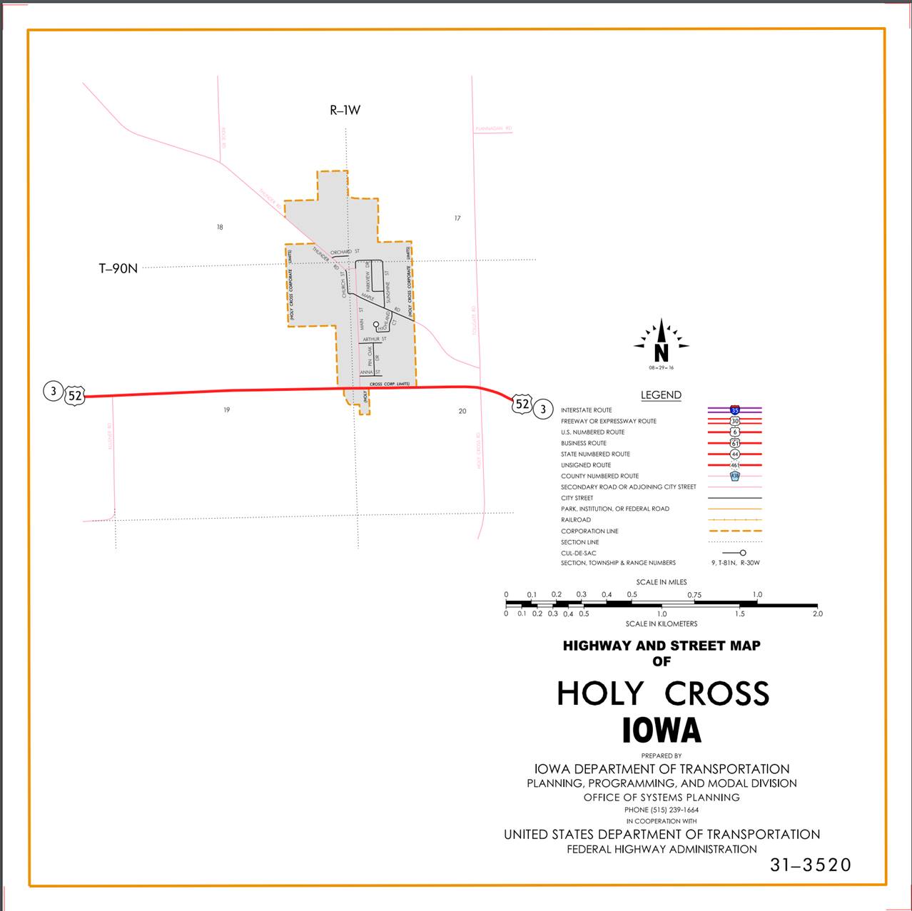
Holy
Cross:
Beginning
at the east corporation line, then west to the west corporation line.
Beginning
again at the west corporation line of Holy Cross; thence west following
substantially the center section line of Sections 19-T90N-R1W and Section
24-T90N-R2W to a point approximately 500 feet west of the E ¼ Corner of Section
24-T90N-R2W; thence in a northwesterly direction through Sections 24 and 23-T90N-R2W
to a point approximately ¼ mile west of the NE Corner of Section 23-T90N-R2W;
thence west following substantially the section line of Sections 23 and
22-T90N-R2W to the east corporation line of Luxemburg connecting with Main
Street.
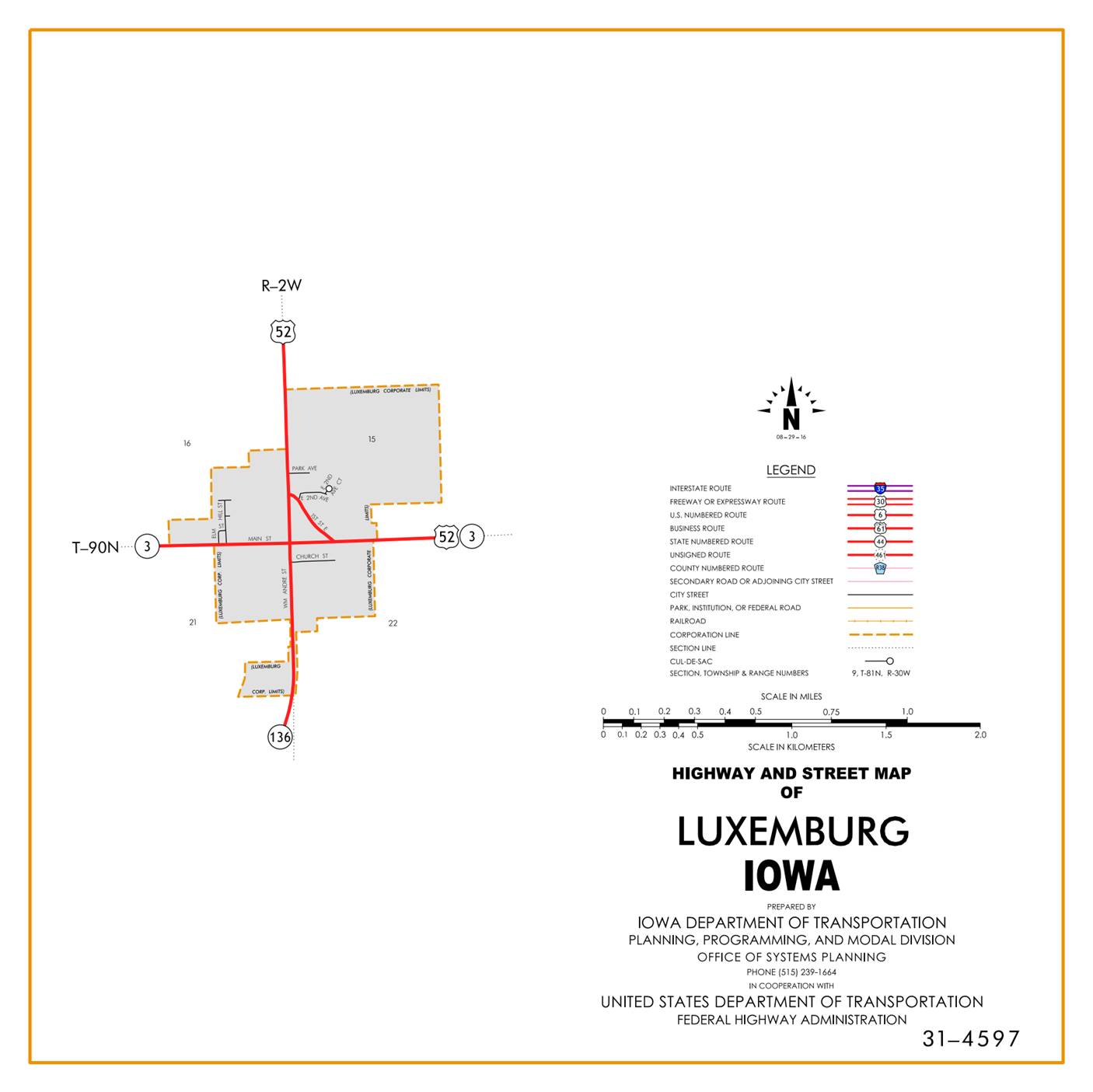
Luxemburg:
Beginning on Main Street at the
east corporation line; thence west on Main
Street to William Andre Street; thence north on William Andre Street
to the north corporation line.
Beginning
again on the north corporation line of Luxemburg connecting with William Andre
Street; thence north following substantially the section line of Sections 15,
10, and 3-T90N-R2W to the Dubuque-Clayton County line at a point near the NW
Corner of Section 3-T90N-R2W, Dubuque County (SW Corner of Section 34-T91N-R2W,
Clayton County).
Beginning
on the Dubuque-Jackson County line at a point approximately 1,700 feet west of
the SE Corner of Section 35-T88N-R3E, Dubuque County (NE Corner of Section
2-T87N-R3E, Jackson County); thence in a northwesterly direction through
Sections 35, 34, 27, 28, 21, 20, 21, 16, 17, 8, 7 and 6-T88N-R3E, and in a
northwesterly direction in Section 1-T88N-R2E to a point approximately ¼ mile
north of 0.4 mile west of the SE Corner of Section 1-T88N-R2E (south junction
US 61 and US 151); thence in a northeasterly and northerly direction through
Section 1-T88N-R2E to the south corporation line of Dubuque connecting with
Kerrigan Road.
Dubuque:
Beginning on Kerrigan Road
at the south corporation line; thence north on Kerrigan Road to South Locust
Street; thence northeast and north on unnamed street to 9th and 11th Street off
ramp; thence northeast on off ramp (begin one-way northbound) to 11th Street;
thence southwesterly on 11th Street to White Street; thence northwesterly on
White Street to 21st Street; thence southwesterly on 21st Street to Central
Avenue (end one-way northbound); thence northwesterly on Central Avenue to the
north corporation line.
Also
Beginning on Central Avenue at an
intersection with 21st Street
(begin one-way southbound); thence southeasterly on Central Avenue to East 9th Street; thence
northwesterly on East 9th Street
to southbound onramp; thence southbound to unnamed street (end one-way
southbound).
Beginning
on the north corporation line of Dubuque connecting with Central Avenue; thence
in a northwesterly direction through Sections 11, 2 and 3-T89N-R2E, in a
northwesterly and southwesterly direction through Sections 34 and 33-T90N-R2E,
and Sections 4 and 5-T89N-R2E to a point approximately 700 feet south and 700
feet west of the NE Corner of Section 5-T89N-R2E; thence in a northwesterly and
westerly direction through Section 5-T89N-R2E and Sections 32 and 31-T90N-R2E
to the east corporation line of Durango connecting with an unnamed street.
Durango:
Beginning on an unnamed
street at the east corporation line; thence westerly, southwesterly, and
westerly on unnamed street to the west corporation line.
Beginning
again on the west corporation line of Durango connecting with an unnamed
street; thence in a northwesterly direction through Section 31-T90N-R2E and
Sections 36, 35, 26, 27 and 28-T90N-R1E to the east corporation line of Rickardsville connecting with Main Street.
Rickardsville:
Beginning on Main Street at the
east corporation line; thence westerly on Main Street to the west corporation line.
Beginning
again on the west corporation line of Rickardsville
connecting with Main Street; thence in a northwesterly direction through
Sections 29 and 30-T90N-R1E to the east corporation line of Rickardsville
connecting with Main Street.
Rickardsville:
Beginning again on Main Street at the
east corporation line; thence westerly on Main Street to the west corporation line.
Beginning
on the west corporation line of Rickardsville
connecting with Main Street; thence in a westerly direction through Section
30-T90N-R1E and Section 25, 26, 27, 28, 21 and 20-T90N-R1W to a point near the
center of Section 20-T90N-R1W; thence west following substantially the center
section line of Sections 20 and 19-T90N-R1W and Section 24-T90N-R2W to a point
approximately 500 feet west of the E ¼ Corner of Section 24-T90N-R2W; thence in
a northwesterly direction through Sections 24 and 23-T90N-R2W to a point
approximately ¼ mile west of the NE Corner of Section 23-T90N-R2W; thence west
following substantially the section line of Sections 23 and 22-T90N-R2W to the
east corporation line of Luxemburg connecting with Main Street.
Luxemburg:
Beginning on Main Street at the
east corporation line; thence west on Main
Street to William Andre Street; thence north on William Andre Street
to the north corporation line.
Beginning
again on the north corporation line of Luxemburg connecting with William Andre
Street; thence north following substantially the section line of Sections 15,
10, and 3-T90N-R2W to the Dubuque-Clayton County line at a point near the NW
Corner of Section 3-T90N-R2W, Dubuque County (SW Corner of Section 34-T91N-R2W,
Clayton County).
STAFF ACTION
OFFICE: Transportation Data
STAFF
ACTION NUMBER:
S‑97‑0511
SUBMITTED
BY:
Patrick R. Cain
SUBMITTAL
DATE: 11‑06‑96
DISCUSSION/BACKGROUND:
Transfer
of jurisdiction agreement number 96-TJ-001 between the Iowa Department of
Transportation and the city of Dubuque
transferred sections of 11th
Street, White
Street and 21st Street to the State on November 1,
1996. (City and State will have
co-jurisdiction.)
PROPOSAL/ACTION
RECOMMENDATION:
It
is recommended that the old description of US 52 in Dubuque County be deleted from the Primary
Road System and the new description, as described in the attachment, be
included in the Primary Road System.
New
Description - US 52 and its extensions in Dubuque County
described as follows:
Beginning
on the Dubuque-Jackson County line at a point approximately 1,700 feet west of
the SE Corner of Section 35-T88N-R3E, Dubuque County (NE Corner of Section
2-T87N-R3E, Jackson County); thence in a northwesterly direction through
Sections 35, 34, 27, 28, 21, 20, 21, 16, 17, 8, 7 and 6-T88N-R3E, and in a
northwesterly direction in Section 1-T88N-R2E to a point approximately ¼ mile
north of 0.4 mile west of the SE Corner of Section 1-T88N-R2E (south junction
US 61 and US 151); thence in a northeasterly and northerly direction through
Section 1-T88N-R2E to the south corporation line of Dubuque connecting with
Kerrigan Road.
Dubuque:
Beginning on Kerrigan Road
at the south corporation line; thence north on Kerrigan Road to South Locust
Street; thence northeast and north on unnamed street to 9th and 11th Street off
ramp; thence northeast on off ramp (begin one-way northbound) to 11th Street;
thence southwesterly on 11th Street to White Street; thence northwesterly on
White Street to 21st Street; thence southwesterly on 21st Street to Central
Avenue (end one-way northbound); thence northwesterly on Central Avenue to the
north corporation line.
Also
Beginning on Central Avenue at an
intersection with 21st Street
(begin one-way southbound); thence southeasterly on Central Avenue to East 9th Street; thence
northwesterly on East 9th Street
to southbound onramp; thence southbound to unnamed street (end one-way
southbound).
Beginning
on the north corporation line of Dubuque connecting with Central Avenue; thence
in a northwesterly direction through Sections 11, 2 and 3-T89N-R2E, in a
northwesterly and southwesterly direction through Sections 34 and 33-T90N-R2E,
and Sections 4 and 5-T89N-R2E to a point approximately 700 feet south and 700
feet west of the NE Corner of Section 5-T89N-R2E; thence in a northwesterly and
westerly direction through Section 5-T89N-R2E and Sections 32 and 31-T90N-R2E
to the east corporation line of Durango connecting with an unnamed street.
Durango:
Beginning on an unnamed
street at the east corporation line; thence westerly, southwesterly, and
westerly on unnamed street to the west corporation line.
Beginning
again on the west corporation line of Durango connecting with an unnamed
street; thence in a northwesterly direction through Section 31-T90N-R2E and
Sections 36, 35, 26, 27 and 28-T90N-R1E to the east corporation line of Rickardsville connecting with Main Street.
Rickardsville:
Beginning on Main Street at the
east corporation line; thence westerly on Main Street to the west corporation line.
Beginning
again on the west corporation line of Rickardsville
connecting with Main Street; thence in a northwesterly direction through
Sections 29 and 30-T90N-R1E to the east corporation line of Rickardsville
connecting with Main Street.
Rickardsville:
Beginning again on Main Street at the
east corporation line; thence westerly on Main Street to the west corporation line.
Beginning
on the west corporation line of Rickardsville
connecting with Main Street; thence in a westerly direction through Section
30-T90N-R1E and Section 25, 26, 27, 28, 21 and 20-T90N-R1W to a point near the
center of Section 20-T90N-R1W; thence west following substantially the center
section line of Sections 20 and 19-T90N-R1W and Section 24-T90N-R2W to a point
approximately 500 feet west of the E ¼ Corner of Section 24-T90N-R2W; thence in
a northwesterly direction through Sections 24 and 23-T90N-R2W to a point
approximately ¼ mile west of the NE Corner of Section 23-T90N-R2W; thence west
following substantially the section line of Sections 23 and 22-T90N-R2W to the
east corporation line of Luxemburg connecting with Main Street.
Luxemburg:
Beginning on Main Street at the
east corporation line; thence west on Main
Street to William Andre Street; thence north on William Andre Street
to the north corporation line.
Beginning
again on the north corporation line of Luxemburg connecting with William Andre
Street; thence north following substantially the section line of Sections 15,
10, and 3-T90N-R2W to the Dubuque-Clayton County line at a point near the NW
Corner of Section 3-T90N-R2W, Dubuque County (SW Corner of Section 34-T91N-R2W,
Clayton County).
STAFF
ACTION
OFFICE:
Transportation
Data
STAFF
ACTION NUMBER: S-96-1279
SUBMITTED
BY: Patrick
R. Cain
SUBMITTAL
DATE: 2-14-96
DISCUSSION/BACKGROUND:
Due
to the relocation of several routes in Dubuque
in 1991, the routing for US 52 was revised and the official description in the
Primary Road System should be revised to reflect this change.
PROPOSAL/ACTION
RECOMMENDATION:
It
is recommended that the old description of US 52 in Dubuque County be deleted from the Primary
Road System and the new description, as described in the attachment, be
included in the Primary Road System.
New Description - US 52 and its extensions in
Dubuque County described as follows:
Beginning on the Dubuque-Jackson County line
at a point approximately 1,700 feet west of the SE Corner of Section
35-T88N-R3E, Dubuque County (NE Corner of Section 2-T87N-R3E, Jackson County);
thence in a northwesterly direction through Sections 35, 34, 27, 28, 21, 20,
21, 16, 17, 8,7 and 6-T88N-R3E, and in a northwesterly direction in Section
1-T88N-R2E to a point approximately ¼ mile north of 0.4 mile west of the SE
Corner of Section 1-T88N-R2E (south junction US 61 and US 151); thence in a
northeasterly and northerly direction through Section 1-T88N-R2E to the south
corporation line of Dubuque connecting with Kerrigan Road.
Dubuque:
Beginning
on Kerrigan Road at the south corporation line; thence north on Kerrigan Road
to South Locust Street; thence northeast and north on unnamed street to near
3rd Street; thence northeast (begin one-way northbound) to White Street; thence
northwesterly on White Street to 21st Street; thence southwesterly on 21st
Street to Central Avenue (end one-way northbound); thence northwesterly on
Central Avenue to the north corporation line.
Also
Beginning
on Central Avenue
at an intersection with 21st
Street (begin one-way southbound); thence
southeasterly on Central Avenue
to 4th Street;
thence southwesterly on unnamed street to near 3rd street (end one-way southbound).
Beginning on the north corporation line of
Dubuque connecting with Central Avenue; thence in a northwesterly direction
through Sections 11, 2 and 3-T89N-R2E, in a northwesterly and southwesterly
direction through Sections 34 and 33-T90N-R2E, and Sections 4 and 5-T89N-R2E to
a point approximately 700 feet south and 700 feet west of the NE Corner of
Section 5-T89N-R2E; thence in a northwesterly and westerly direction through
Section 5-T89N-R2E and Sections 32 and 31-T90N-R2E to the east corporation line
of Durango connecting with an unnamed street.
Durango:
Beginning
on an unnamed street at the east corporation line; thence westerly,
southwesterly, and westerly on unnamed street to the west corporation line.
Beginning again on the west corporation line
of Durango connecting with an unnamed street; thence in a northwesterly
direction through Section 31-T90N-R2E and Sections 36, 35, 26, 27 and
28-T90N-RlE to the east corporation line of Rickardsville
connecting with Main Street.
Rickardsville:
Beginning
on Main Street
at the east corporation line; thence westerly on Main Street to the west corporation line.
Beginning again on the west corporation line
of Rickardsville connecting with Main Street; thence
in a northwesterly direction through Sections 29 and 30-T90N-RlE to the east
corporation line of Rickardsville connecting with
Main Street.
Rickardsville:
Beginning
again on Main Street
at the east corporation line; thence westerly on Main Street to the west corporation line.
Beginning on the west corporation line of Rickardsville connecting with Main Street; thence in a
westerly direction through Section 30-T90N-RlE and Section 25, 26, 27, 28, 21
and 20-T90N-RlW to a point near the center of Section 20-T90N-RlW; thence west
following substantially the center section line of Sections 20 and 19-T90N-RlW
and Section 24-T90N-R2W to a point approximately 500 feet west of the E ¼
Corner of Section 24-T90N-R2W; thence in a northwesterly direction through
Sections 24 and 23-T90N-R2W to a point approximately ¼ mile west of the NE
Corner of Section 23-T90N-R2W; thence west following substantially the section
line of Sections 23 and 22-T90N-R2W to the east corporation line of Luxemburg
connecting with Main Street.
Luxemburg:
Beginning
on Main Street
at the east corporation line; thence west on Main Street to William Andre Street; thence north on William Andre Street
to the north corporation line.
Beginning again on the north corporation line
of Luxemburg connecting with William Andre Street; thence north following substantially
the section line of Sections 15, 10, and 3-T90N-R2W to the Dubuque-Clayton
County line at a point near the NW Corner of Section 3-T90N-R2W, Dubuque County
(SW Corner of Section 34-T91N-R2W, Clayton County).
STAFF
ACTION
OFFICE:
Transportation
Data
STAFF
ACTION NUMBER: S-96-1237
SUBMITTED
BY: Patrick
R. Cain
SUBMITTAL
DATE: 3-5-96
DISCUSSION/BACKGROUND:
Due
to the relocation of US 52 in Dubuque
in 1993, the official description in the Primary Road System should be revised
to reflect this change.
Transfer
of jurisdiction agreement number 93-TJ-004 between the Iowa Department of
Transportation and the City of Dubuque
transferred the section of Central
Avenue to the city on October 8, 1993.
At
the same time the section of White
Street which was already the city's but being used
by the Department of Transportation, was given back to the city.
PROPOSAL/ACTION
RECOMMENDATION:
It
is recommended that the old description of US 52 in Dubuque County be deleted from the Primary
Road System and the new description, as described in the attachment, be
included in the Primary Road System.
New
Description - US 52 and its extensions in Dubuque County
described as follows:
Beginning
on the Dubuque-Jackson County line at a point approximately 1,700 feet west of
the SE Corner of Section 35-T88N-R3E, Dubuque County (NE Corner of Section
2-T87N-R3E, Jackson County); thence in northwesterly direction through Sections
35, 34, 27, 28, 21, 20, 21, 16, 17, 8, 7 and 6-T88N-R3E, and in a northwesterly
direction in Section 1-T88N-R2E to a point approximately ¼ mile north of 0.4
mile west of the SE Corner of Section 1-T88N-R2E; (south junction US 61 and US
151); thence in a northeasterly and northerly direction through Section
1-T88N-R2E to the south corporation line of Dubuque connecting with Kerrigan
Road.
Dubuque:
Beginning on Kerrigan Road
at the south corporation line; thence north on Kerrigan Road to South Locust
Street; thence northeast and north on unnamed street to near E. 6th Street; thence
northeast on off ramp (begin one-way northbound) to 11th Street; thence
southwesterly on 11th Street to White Street; thence northwesterly on White
Street to 21st Street; thence southwesterly on 21st Street to Central Avenue
(end one-way northbound); thence northwesterly on Central Avenue to the north
corporation line.
Also
Beginning
on Central Avenue
at an intersection with 21st
Street (begin one-way southbound); thence
southeasterly on Central Avenue
to East 9th Street; thence northeasterly on East 9th Street to southbound onramp;
thence southbound to unnamed street (end one-way southbound).
Beginning
on the north corporation line of Dubuque connecting with Central Avenue; thence
in a northwesterly direction through Sections 11, 2 and 3-T89N-R2E, in a
northwesterly and southwesterly direction through Sections 34 and 33-T90N-R2E,
and Sections 4 and 5-T89N-R2E to a point approximately 700 feet south and 700
feet west of the NE Corner of Section 5-T89N-R2E; thence in a northwesterly and
westerly direction through Section 5-T89N-R2E and Sections 32 and 31-T90N-R2E
to the east corporation line of Durango connecting with an unnamed street.
Durango:
Beginning
on an unnamed street at the east corporation line; thence westerly,
southwesterly, and westerly on unnamed street to the west corporation line.
Beginning
again on the west corporation line of Durango connecting with an unnamed
street; thence in a northwesterly direction through Section 31-T90N-R2E and Sections
36, 35, 26, 27 and 28-T90N-R1E to the east corporation line of Rickardsville connecting with Main Street.
Rickardsville:
Beginning
on Main Street
at the east corporation line; thence westerly on Main Street to the west corporation line.
Beginning
again on the west corporation line of Rickardsville
connecting with Main Street; thence in a northwesterly direction through
Sections 29 and 30-T90N-RlE to the east corporation line of Rickardsville
connecting with Main Street.
Rickardsville:
Beginning again on Main Street at the
east corporation line; thence westerly on Main Street to the west corporation line.
Beginning
on the west corporation line of Rickardsville
connecting with Main Street; thence in a westerly direction through Section
30-T90N-RlE and Section 25, 26, 27, 28, 21 and 20-T90N-R1W to a point near the
center of Section 20-T90N-RlW; thence west following substantial y the center
section line of Sections 20 and 19-T90N-RlW and Section 24-T90N-R2W to a point
approximately 500 feet west of the E ¼ Corner of Section 24-T90N-R2W; thence in
a northwesterly direction through Sections 24 and 23-T90N-R2W to a point
approximately ¼ mile west of the NE Corner of Section 23-T90N-R2W; thence west
following substantially the section line of Sections 23 and 22-T90N-R2W to the
east corporation line of Luxemburg connecting with Main Street.
Luxemburg:
Beginning
on Main Street
at the east corporation line; thence west on Main Street to William Andre Street;
thence on William Andre Street
to the north corporation line.
Beginning
again on the north corporation line of Luxemburg connecting with William Andre
Street; thence north following substantially the section line of Sections 15,
10 and 3-T90N-R2W to the Dubuque-Clayton County line at a point near the NW
Corner of Section 3-T90N-R2W, Dubuque County (SW Corner of Section 34-T91N-R2W,
Clayton County).
OFFICIAL
DESCRIPTION CHANGE
COUNTY: Dubuque
ROUTE: US 52
STAFF
ACTION NUMBER: S‑87‑718
APPROVAL
DATE: 12‑18‑86
New
Description ‑ US 52 and its extensions in Dubuque County
described as follows:
Beginning
on the Dubuque‑Jackson County line at a point approximately 1,700 feet
west of the SE Corner of Section 35‑T88N‑R3E, Dubuque County (NE
Corner of Section 2‑T87N‑R3E, Jackson County); thence in a
northwesterly direction through Sections 35, 34, 27, 28, 21, 20, 21, 16, 17, 8,
7, and 6‑T88N‑R3E, and in a northwesterly direction in Section 1‑T88N‑R2E
to a point approximately ¼ mile north and 0.4 mile west of the SE Corner of
Section 1‑T88N‑R2E; (south junction US 61 and US 151); thence in a
northeasterly and northerly direction through Section 1‑T88N‑R2E to
the south corporation line of Dubuque connecting with Kerrigan Road.
Dubuque:
Beginning on Kerrigan Road
at the south corporation line; thence north on Kerrigan Road to South Locust
Street; thence north on South Locust Street to Dodge Street; thence north (begin
one way northbound) on Locust Street to 4th Street; thence east on 4th Street
to White Street; thence northwesterly on White Street to 21st Street; thence
southwesterly on 21st Street to Central Avenue; (end one way northbound);
thence northwesterly on Central Avenue to the north corporation line.
Also
with a spur
Beginning on Central Avenue at an
intersection with 21st Street
(begin one way southbound); thence southeasterly on Central Avenue to 5th Street; thence
southwesterly on 5th Street
to Bluff Street; thence southeasterly on Bluff Street to Dodge Street (US 20) (end one way southbound).
Beginning
on the north corporation line of Dubuque connecting with Central Avenue; thence
in a northwesterly direction through Sections 11, 2, and 3‑T89N‑R2E,
in a northwesterly and southwesterly direction through Sections 34 and 33‑T90N‑R2E,
and Sections 4 and 5‑T89N‑R2E to a point approximately 700 feet
south and 700 feet west of the NE Corner of Section 5‑T89N‑R2E;
thence in a northwesterly and westerly direction through Section 5‑T89N‑R2E
and Sections 32 and 31‑T90N‑R2E to the east corporation line of
Durango connecting with an unnamed street.
Durango:
Beginning
on an unnamed street at the east corporation line; thence westerly,
southwesterly, and westerly on unnamed street to the west corporation line.
Beginning
again on the west corporation line of Durango connecting with an unnamed
street; thence in a northwesterly direction through Section 31‑T90N‑R2E
and Sections 36, 35, 26, 27, and 28‑T90N‑R1E to the east
corporation line of Rickardsville connecting with
Main Street.
Rickardsville:
Beginning on Main Street at the
east corporation line; thence westerly on Main Street to the west corporation line.
Beginning
again on the west corporation line of Rickardsville
connecting with Main Street; thence in a northwesterly direction through
Sections 29 and 30‑T90N‑R1E to the east corporation line of Rickardsville connecting with Main Street.
Rickardsville:
Beginning
again on Main Street
at the east corporation line; thence westerly on Main Street to the west corporation line.
Beginning
again on the west corporation line of Rickardsville
connecting with Main Street; thence in a westerly direction through Section 30‑T90N‑R1E
and Section 25, 26, 27, 28, 21, and 20‑T90N‑R1W to a point near the
center of Section 20‑T90N‑R1W; thence west following substantially
the center section line of Seas. 20 and 19‑T90N‑R1W and Section 24‑T90N‑R2W
to a point approximately 500 feet west of the E ¼ Corner of Section 24‑T90N‑R2W;
thence in a northwesterly direction through Sections 24 and 23‑T90N‑R2W
to a point approximately ¼ mile west of the NE Corner of Section 23‑T90N‑R2W;
thence west following substantially the section line of Sections 23 and 22‑T90N‑R2W
to the east corporation line of Luxemburg connecting with Main Street.
Luxemburg:
Beginning
on Main Street
at the east corporation line; thence west on Main Street to William Andre Street; thence north on William Andre Street
to the north corporation line.
Beginning
again on the north corporation line of Luxemburg connecting with William Andre
Street; thence north following substantially the section line of Sections 15,
10, and 3‑T90N‑R2W to the Dubuque‑Clayton county line at a
point near the NW Corner of Section 3‑T90N‑R2W, Dubuque County (SW
Corner of Section 34‑T91N‑R2W, Clayton County).
COMMISSION ORDER
DIVISION: Planning & Research
COMMISSION
ORDER NUMBER: PR‑82‑747
SUBMITTED
BY: Patrick R. Cain
MEETING
DATE: 6‑8‑82
DISCUSSION/BACKGROUND:
In
Dubuque County, US
52 begins at the Jackson County line approximately eight miles southeast of
the City of Dubuque, and travels generally
northwesterly via the cities of Dubuque, Durango, Rickardsville and
Luxemburg to the Clayton County line approximately three miles north of the
City of Luxemburg.
The
official description for US 52 in Dubuque
County was found to be incorrect in our official records. The existing description should be replaced
with the corrected version.
PROPOSAL/ACTION
RECOMMENDATION:
It
is recommended the commission approve deleting the present description of US 52
in Dubuque
County from the primary road system and approve including the attached new
description of US 52 in the primary road system.
Locate
US 52 and its extensions in Dubuque
County as follows:
Beginning
on the Dubuque‑Jackson County line at a point approximately 1,700 feet
west of the SE Corner of Section 35‑T88N‑R3E, Dubuque County (NE Corner
of Section 2‑T87N‑R3E, Jackson County); thence in a northwesterly
direction through Sections 35, 34, 27, 28, 21, 20, 21, 16, 17, 8, 7, and 6‑T88N‑R3E,
and in a northwesterly direction in Section 1‑T88N‑R2E to a point
approximately ¼ mile north and 0.4 mile west of the SE Corner of Section 1‑T88N‑R2E;
(south junction US 61 and US 151); thence in a northeasterly and northerly
direction through Section 1‑T88N‑R2E to the south corporation line
of the City of Dubuque connecting with an unnamed street.
Dubuque:
Beginning
at the south corporation line connecting with an unnamed street; thence
northerly, northwesterly, northeasterly, and northwesterly to the north
corporation line connecting with an unnamed street.
Also
with a spur
Beginning
at the intersection of Central
Avenue and East 21st Street (begin one way
southbound); thence southeasterly, southwesterly, and southeasterly to Dodge Street (end of
one way southbound).
Beginning
on the north corporation line of the City of Dubuque connecting with an unnamed
street; thence in a northwesterly direction through Sections 11, 2, and 3‑T89N‑R2E,
in a northwesterly and southwesterly direction through Sections 34 and 33‑T90N‑R2E,
and Sections 4 and 5‑T89N‑R2E to a point approximately 700 feet
south and 700 feet west of the NE Corner of Section 5‑T89N‑R2E;
thence in a northwesterly and westerly direction through Section 5‑T89N‑R2E
and Sections 32 and 31‑T90N‑R2E to the east corporation line of the
City of Durango connecting with an unnamed street.
Durango:
Beginning
at the east corporation line connecting with an unnamed street; thence
westerly, southwesterly, and westerly to the west corporation line connecting
with an unnamed street.
Beginning
again on the west corporation line of the City of Durango connecting with an
unnamed street; thence in a northwesterly direction through Section 31‑T90N‑R2E
and Sections 36, 35, 26, 27, and 28‑T90N‑R1E to the east
corporation line of the City of Rickardsville
connecting with an unnamed street.
Rickardsville:
Beginning
on the east corporation line connecting with an unnamed street; thence westerly
to the west corporation line connecting with an unnamed street.
Beginning
again on the west corporation line of the City of Rickardsville
connecting with an unnamed street; thence in a northwesterly direction through
Sections 29 and 30‑T90N‑R1E to the east corporation line of the
City of Rickardsville connecting with an unnamed
street.
Rickardsville:
Beginning
again on the east corporation line connecting with an unnamed street; thence
westerly to the west corporation line connecting with an unnamed street.
Beginning
again on the west corporation line of the City of Rickardsville
connecting with an unnamed street; thence in a westerly direction through
Section 30‑T90N‑R1E and Sections 25, 26, 27, 28, 21, and 20‑T90N‑R1W
to a point near the center of Section 20‑T90N‑R1W; thence west
following substantially the center section line of Sections 20 and 19‑T90N‑R1W
and Section 24‑T90N‑R2W to a point approximately 500 feet west of
the E ¼ Corner of Section 24‑T90N‑R2W; thence in a northwesterly
direction through Sections 24 and 23‑T90N‑R2W to a point
approximately ¼ mile west of the NE Corner of Section 23‑T90N‑R2W;
thence west following substantially the section line of Sections 23 and 22‑T90N‑R2W
to the east corporation line of the City of Luxemburg connecting with an
unnamed street.
Luxemburg:
Beginning
at the east corporation line connecting with an unnamed street; thence westerly
and northerly to the north corporation line connecting with an unnamed street.
Beginning
again on the north corporation line of the City of Luxemburg connecting with an
unnamed street; thence north following substantially the section line of
Sections 15, 10, and 3‑T90N‑R2W to the Dubuque‑Clayton county
line at a point near the NW Corner of Section 3‑T90N‑R2W; Dubuque
County (SW Corner of Section 34‑T91N‑R2W, Clayton County).
REVISED: 12‑18‑86
COMMISSION ORDER
DIVISION: Planning & Research
COMMISSION
ORDER NUMBER: PR‑79‑272
SUBMITTED
BY: C.I. MacGillivray
MEETING
DATE: 11‑2‑78
DISCUSSION/BACKGROUND:
Due
to a review of our Primary Road System records, US 52 in Dubuque County should
be deleted, and the new description added should be officially included into
the Primary Road System.
US
52 begins at the Dubuque‑Jackson County line approximately 8 miles
southeast of Dubuque and travels in a northwesterly direction to the Dubuque‑Delaware
County line approximately 2 ½ miles north of Luxemburg via the Cities of
Dubuque, Durango, Rickardsville, and Luxemburg, Iowa.
PROPOSAL/ACTION
RECOMMENDATION:
Locate
US 52 and its extensions in Dubuque
County as follows:
Beginning
on the Dubuque‑Jackson County line at a point approximately 1,700 feet
west of the SE Corner of Section 35‑T88N‑R3E, Dubuque County (NE
Corner of Section 2‑T87N‑R3E, Jackson County); thence in a
northwesterly direction through Sections 35, 34, 27, 28, 21, 20, 17, 8, 7, and
6‑T88N‑R3E, and in a northwesterly direction in Section 1‑T88N‑R2E
to a point approximately ¼ mile north and 0.4 mile west of the SE Corner of
Section 1‑T88N‑R2E; thence in a northeasterly and northerly
direction through Section 1‑T88N‑R2E to the south corporation line
of the City of Dubuque connecting with an unnamed street.
Dubuque:
Beginning at the south
corporation line connecting with an unnamed street; thence northerly,
northwesterly, northeasterly and northwesterly to the north corporation line
connecting with an unnamed street.
Also
with a spur
Beginning at the
intersection of Central Avenue
and East 21st Street
(begin one way southbound); thence southeasterly, southwesterly, and
southeasterly to Dodge Street
(end of one way southbound).
Beginning
on the north corporation line of the City of Dubuque connecting with an unnamed
street; thence in a northwesterly direction through Sections 11, 2, and 3‑T89N‑R2E,
in a northwesterly and southwesterly direction through Sections 34 and 33‑T90N‑R2E,
and Section 5‑T89N‑R2E to a point approximately 700 feet south and
700 feet west of the NE Corner of Section 5‑T89N‑R2E; thence in a
northwesterly and westerly direction through Section 5‑T89N‑R2E and
Sections 32 and 31‑T90N‑R2E to the east corporation line of the City
of Durango connecting with an unnamed street.
Durango:
Beginning at the east
corporation line connecting with an unnamed street; thence westerly,
southwesterly, and westerly to the west corporation line connecting with an
unnamed street.
Beginning
again on the west corporation line of the City of Durango connecting with an
unnamed street; thence in a northwesterly direction through Section 31‑T90N‑R2E
and Sections 36, 35, 26, 27, and 28‑T90N‑R1E to the east
corporation line of the City of Rickardsville
connecting with an unnamed street.
Rickardsville:
Beginning on the east
corporation line connecting with an unnamed street thence westerly to the west
corporation line connecting with an unnamed street.
Beginning
again on the west corporation line of the City of Rickardsville
connecting with an unnamed street; thence in a southwesterly and northwesterly
direction to the east corporation line of the City of Rickardsville
connecting with an unnamed street.
Rickardsville:
Beginning again on the
east corporation line connecting with an unnamed street; thence westerly to the
west corporation line connecting with an unnamed street.
Beginning
again on the west corporation line of the City of Rickardsville
connecting with an unnamed street; thence in a westerly direction through
Section 30‑T90N‑R1E and Sections 25, 26, 27, 28, 21, and 20‑T90N‑R1W
to a point near the center of Section 20‑T90N‑R1W; thence west
following substantially the center section line of Sections 20 and 19‑T90N‑R1W
and Section 24‑T90N‑R2W to a point approximately 500 feet west of
the E ¼ Corner of Section 24‑T90N‑R2W; thence in a northwesterly
direction through Sections 24 and 23‑T90N‑R2W to a point
approximately ¼ mile west of the NE Corner of Section 23‑T90N‑R2W;
thence west following substantially the section line of Sections 23 and 22‑T90N‑R2W
to the east corporation line of the City of Luxemburg connecting with an
unnamed street.
Luxemburg:
Beginning at the east
corporation line connecting with an unnamed street; thence westerly and northerly
to the north corporation line connecting with an unnamed street.
Beginning
again on the north corporation line of the City of Luxemburg connecting with an
unnamed street; thence north following substantially the section line of
Sections 15, 10, and 3‑T90N‑R2W to the Dubuque‑Clayton County
line at a point near the NW Corner of Section 3‑T90N‑R2W, Dubuque
County (SW Corner of Section 34‑T91N‑R2W, Clayton County).
NOW,
THEREFORE: Be it resolved that the Iowa Department of Transportation approve
the location of US 52, in Dubuque County, Iowa.
NOTE:
To become effective upon the adoption of this resolution.
COMMISSION
ORDER
DIVISION: Planning & Research
SUBMITTED
BY: Raymond L. Kassel
MEETING
DATE: 10‑5‑76
DISCUSSION/BACKGROUND:
Due
to a review of our Primary Road System records, US 52 in Dubuque County should
be deleted, and the new description added should be officially included into
the Primary Road System.
US
52 begins at the Dubuque‑Jackson County line approximately 8 miles
southeast of Dubuque and travels in a northwesterly direction to the Dubuque‑Delaware
County line approximately 2 ½ miles north of Luxemburg via the Cities of
Dubuque, Durango, Rickardsville, and Luxemburg, Iowa.
PROPOSAL/ACTION
RECOMMENDATION:
Locate
US 52 and its extensions in Dubuque
County as follows:
Beginning
on the Dubuque‑Jackson County line at a point approximately 1,700 feet
west of the SE Corner of Section 35‑T88N‑R3E, Dubuque County (NE
Corner of Section 2‑T87N‑R3E, Jackson County); thence in a
northwesterly direction through Sections 35, 34, 27, 28, 21, 20, 17, 8, 7, and
6‑T88N‑R3E, and in a northwesterly direction in Section 1‑T88N‑R2E
to a point approximately ¼ mile north and 0.4 mile west of the SE Corner of
Section 1‑T88N‑R2E; thence in a northeasterly and northerly
direction through Section 1‑T88N‑R2E to the south corporation line
of the City of Dubuque connecting with an unnamed street.
Dubuque:
Beginning
at the south corporation line connecting with an unnamed street; thence
northerly, northwesterly, northeasterly, and northwesterly to the north
corporation line connecting with an unnamed street.
Also
with a spur
Beginning
at the intersection of Central
Avenue and East 21st Street (begin one way
southbound); thence southeasterly, southwesterly, and southeasterly to Dodge Street (end of
one way southbound).
Beginning
on the north corporation line of the City of Dubuque connecting with an unnamed
street; thence in a northwesterly direction through Sections 11, 2, and 3‑T89N‑R2E,
in a northwesterly and southwesterly direction through Sections 34 and 33‑T90N‑R2E,
and Section 5‑T89N‑R2E to a point approximately 700 feet south and
700 feet west of the NE Corner of Section 5‑T89N‑R2E; thence in a
northwesterly and westerly direction through Section 5‑T89N‑R2E and
Sections 32 and 31‑T90N‑R2E to the east corporation line of the City
of Durango connecting with an unnamed street.
Durango:
Beginning
at the east corporation line connecting with an unnamed street; thence
westerly, southwesterly, and westerly to the west corporation line connecting
with an unnamed street.
Beginning
again on the west corporation line of the City of Durango connecting with an
unnamed street; thence in a northwesterly direction through Section 31‑T90N‑R2E
and Sections 36, 35, 26, 27, and 28‑T90N‑R1E to the east
corporation line of the City of Rickardsville
connecting with an unnamed street.
Rickardsville:
Beginning
on the east corporation line connecting with an unnamed street thence westerly
to the west corporation line connecting with an unnamed street.
Beginning
again on the west corporation line of the City of Rickardsville
connecting with an unnamed street; thence in a southwesterly and northwesterly
direction to the east corporation line of the City of Rickardsville
connecting with an unnamed street.
Rickardsville:
Beginning
again on the east corporation line connecting with an unnamed street; thence
westerly to the west corporation line connecting with an unnamed street.
Beginning
again on the west corporation line of the City of Rickardsville
connecting with an unnamed street; thence in a westerly direction through
Section 30‑T90N‑R1E and Sections 25, 26, 27, 28, 21, and 20‑T90N‑R1W
to a point near the center of Section 20‑T90N‑R1W; thence west
following substantially the center section line of Sections 20 and 19‑T90N‑R1W
and Section 24‑T90N‑R2W to a point approximately 500 feet west of
the E ¼ Corner of Section 24‑T90N‑R2W; thence in a northwesterly
direction through Sections 24 and 23‑T90N‑R2W to a point
approximately ¼ mile west of the NE Corner of Section 23‑T90N‑R2W;
thence west following substantially the section line of Sections 23 and 22‑T90N‑R2W
to the east corporation line of the City of Luxemburg connecting with an
unnamed street.
Luxemburg:
Beginning
at the east corporation line connecting with an unnamed street; thence westerly
and northerly to the north corporation line connecting with an unnamed street.
Beginning
again on the north corporation line of the City of Luxemburg connecting with an
unnamed street; thence north following substantially the section line of
Sections 15, 10, and 3‑T90N‑R2W to the Dubuque‑Clayton County
line at a point near the NW Corner of Section 3‑T90N‑R2W, Dubuque
County (SW Corner of Section 34‑T91N‑R2W, Clayton County).
NOW,
THEREFORE: Be it resolved that the Iowa Department of Transportation approve
the location of US 52 in Dubuque County, Iowa.
NOTE:
To become effective upon the adoption of this resolution.
COMMISSION
ORDER
DIVISION: Planning & Research
COMMISSION
ORDER NUMBER: pr‑76‑405
SUBMITTED
BY: Raymond L. Kassel
MEETING
DATE: 3‑9‑76
DISCUSSION/BACKGROUND:
US
52 was relocated north of Dubuque. The new alignment of US 52 in Dubuque County should be
officially included in the State Primary System. In accord with the project agreement with the
Dubuque County Board of Supervisors, disposition of sections of the old
alignment should be made.
PROPOSAL/ACTION
RECOMMENDATION:
Locate
US 52 and its extensions in Dubuque
County as follows:
Beginning
on the Dubuque‑Jackson County line at a point approximately 1,700 feet
west of the SE Corner of Section 35‑T88N‑R3E Dubuque County (NE
Corner of Section 2‑T87N‑R3E Jackson County); thence in a
northwesterly direction through Sections 35, 34, 27, 28, 21, 20, 17, 8, 7, and
6‑T88N‑R3E; and in a northwesterly direction in Section 1‑T86N‑R2E
to a point approximately ¼ mile north and 0.4 mile west of the SE Corner of
Section 1‑T88N‑R2E; thence in a northeasterly and northerly
direction to the south corporation line of the City of Dubuque connecting with
Kerrigan Road.
Beginning
on the north corporation line of the City of Dubuque connecting with Central
Avenue; thence in a northwesterly direction through Sections 11, 2 and 3‑T89N‑R2E,
in a northwesterly and southwesterly direction through Sections 34 and 33‑T90N‑R2E,
to a point approximately 700 feet south and 700 feet west of the NE Corner of
Section 5‑T89N‑R2E; thence in a northwesterly and westerly
direction along the north side of the Chicago, Great Western Railroad and
substantially parallel thereto through Section 5‑T89N‑R2E and
Sections 32 and 31‑T90N‑R2E to the east corporation line of the
City of Durango connecting with an unnamed street.
Beginning
again on the west corporation line of the City of Durango connecting with an
unnamed street; thence in a northwesterly direction through Section 31‑T90N‑R2E
and Sections 36, 35, 26, 27, and 28‑T90N‑R1E to the east
corporation line of the Town of Rickardsville
connecting with Main Street.
Beginning
again on the west corporation line of the City of Rickardsville
connecting with Main Street; thence in a southwesterly and northwesterly
direction to the east corporation line of the Town of Rickardsville
connecting with Main Street.
Beginning
again on the west corporation line of the City of Rickardsville;
thence in a westerly direction through Sections 25, 26, 27, 28, 21, and 20‑T90N‑R1W
to a point near the center of Section 20‑T90N‑R1W; thence west
following substantially the quarter section line to a point approximately 500
feet west of the E ¼ Corner of Section 24‑T90N‑R2W; thence in a
northwesterly direction to a point approximately ¼ mile west of the NE Corner
of Section 23‑T90N‑R2W; thence west following substantially the
section line to the east corporation line of the Town of Luxemburg connecting
with Main Street.
Beginning
again on the north corporation line of the City of Luxemburg connecting with
William Andre Street; thence north following substantially the section line to
the Dubuque‑Clayton County line at a point near the NW Corner of Section
3‑T90N‑R2W Dubuque County (SW Corner of Section 34‑T91N‑R2W
Clayton County).
Dubuque:
Beginning
on Kerrigan Road at the south corporation line; thence northerly on Kerrigan
Road to South Locust Street; thence northerly on South Locust Street to Dodge
Street; thence northerly (begin one way north‑bound) on Locust Street to
Fourth Street; thence easterly on Fourth Street to White Street; thence
northwesterly on White Street to 21st Street; thence southwesterly
on 21st Street to Central Avenue; (end one way northbound); thence northwesterly
on Central Avenue to the north corporation line.
Beginning
on the north corporation connecting with Central Avenue; thence southeasterly
on Central Avenue to 21st Street (begin one way southbound); thence continuing
southeasterly on Central Avenue to 5th Street; thence southwesterly on 5th
Street to Bluff Street; thence southeasterly on Bluff Street to Dodge Street
(US 20)(end one way southbound).
Rickardsville:
Commencing
on Main Street on the east corporation line; thence westerly on Main Street to
the west corporation line.
Beginning
again on Main Street
on the east corporation line; thence westerly on Main Street to the west corporation line.
Luxemburg:
Beginning
on Main Street at the east corporation line; thence west on Main Street to William Andre Street; thence north on William Andre Street
to the north corporation line.
NOW,
THEREFORE: Be it resolved that the Iowa Department of Transportation approve
the location of US 52 and its extension in Dubuque County, Iowa.
NOTE: In accordance with the agreement signed by
the Dubuque County Board of Supervisors, dated September 3, 1974, two sections
of Old US 52, the first from approximately 300 feet north of the intersection
with Rupp Road southerly approximately six tenths (0.6) of a mile to the
connection of Old US 52 with New US 52, the second, a short 500‑foot
section of Old US 52 just west of the north junction of Iowa 386 and New US 52
will revert to the Dubuque County Secondary System. This is to become effective upon adoption of
this resolution.
COMMISSION
RESOLUTION
DIVISION: Planning & Research
COMMISSION
ORDER NUMBER: 67‑1634
SUBMITTED
BY: Raymond L. Kassel
MEETING
DATE: 11‑8‑67
Locate
US 52 in Dubuque
County as follows:
Dubuque:
Beginning
at the intersection of Dodge and Locust Streets; thence northerly on Locust
Street to Fourth Street; thence easterly on Fourth Street to Central Avenue;
thence northwesterly on Central Avenue to the north corporation line.
Beginning
on the north corporation line of the City of Dubuque connecting with Central
Avenue; thence in a northwesterly direction through Sees. 11, 2 and 3‑T89N‑R2E,
in a northwesterly and southwesterly direction through Sections 34 and 33‑T90N‑R2E,
to a point approximately 700 feet south and 700 feet west of the NE Corner of
Section 5‑T89N‑R2E; thence in a northwesterly and westerly
direction along the north side of the Chicago, Great Western Railroad and
substantially parallel thereto through Section 5‑T89N‑R2E and
Section 32 and 31‑T90N‑R2E to the east corporation line of the Town
of Durango connecting with an unnamed street.
Durango:
Beginning
on an unnamed street at the east corporation line; thence westerly,
southwesterly, and westerly on said unnamed street to the west corporation line.
Beginning
again on the west corporation line of the Town of Durango connecting with an
unnamed street at a point approximately 800 feet east and 900 feet north of the
SW Corner of Section 31‑T90N‑R2E; thence in a westerly direction
through Section 31‑T90N‑R2E, Sections 36, 35, 26, 27, 28, 29 and 30‑T90N‑R1E
and Sections 25, 26, 27, 28, 21 and 20‑T90N‑R1W to a point near the
center of Section 20‑T90N‑R1W; thence west following substantially
the quarter section line to a point approximately 500 feet west of the E ¼
Corner of Section 24‑T90N‑R2W; thence in a northwesterly direction
to a point approximately ¼ mile west of the NE Corner of Section 23‑T90N‑R2W;
thence west following substantially the section line to the east corporation
line of the Town of Luxemburg connecting with Main Street.
Luxemburg:
Beginning
on the east corporation line connecting with Main Street; thence westerly on
Main Street approximately 235 feet; thence northwesterly on an unnamed street
to William Andre Street; thence northerly on William Andre Street to the north
corporation line.