OFFICIAL
DESCRIPTION CHANGE
OFFICE:
Research and Analytics
EFFECTIVE
DATE: 6-14-2019
COUNTY:
Dubuque
ROUTE:
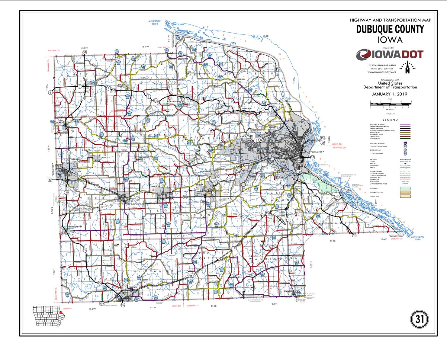
US 20
ENTERED
BY: Paul Mauer
ENTERED
DATE: 08-14-2020
New
Description ‑ US 20 and its extensions in Dubuque County described as
follows:
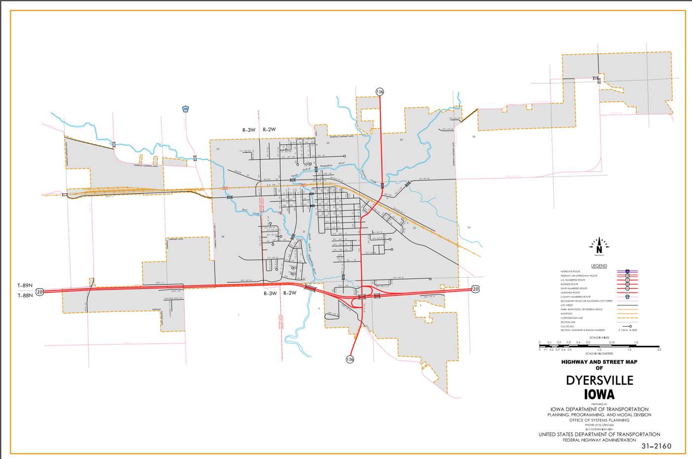
Dyersville:
Beginning
on the Dubuque‑Delaware County line at a point near the NW Corner Section
6‑T88N‑R2W, Dubuque County (NE Corner Section 1‑T88N‑R3W,
Delaware County); thence in an easterly and southeasterly direction to the
south corporation line.
Beginning
again at the south corporation line of Dyersville; thence in a southeasterly
direction through Section 6-T88N-R2W to the west corporation line of
Dyersville.
Dyersville:
Beginning
at the west corporation line; thence easterly to the east corporation line.
Beginning
again at the east corporation line of Dyersville; thence east and southeast
through Sections 5, 4, and 3‑T88N‑R2W to a point approximately 535
feet north and 770 feet east of the W ¼ Corner of Section 3‑T88N‑R2W
on the south side of the Illinois Central Railroad; thence southeast along the
south side of said railroad and substantially parallel thereto through Sections
3, 2, 11, and 12‑T88N‑R2W to the west corporation line of Farley.
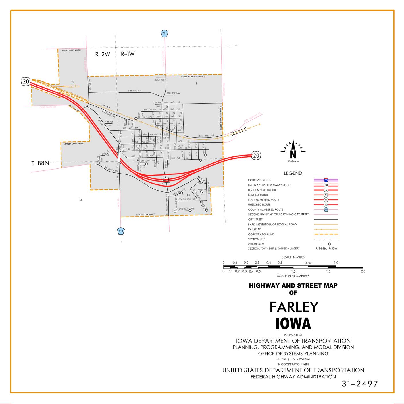
Farley:
Beginning
at the west corporation line; thence southeasterly, easterly, and northeasterly
to the east corporation line.
Beginning again on the
east corporation line of Farley; thence east following substantially the
section line of Sections 17, 16 and 15-T88N-R1W to the west corporation line of
Epworth. 14, and 13‑T88N‑R1W; thence continuing in an easterly
direction through the south part of Section 12‑T88N‑R1W and
Sections 7, 8, 9, and 10‑T88N‑R1E; and east following substantially
the section line of sections 15, 14, and 13‑T88N‑R1E to a point
approximately 1,500 feet west of the NE Corner of Section 13‑T88N‑R1E;
thence curving in a northeasterly direction through Section 12‑T88N‑R1E
and continuing northeasterly, northerly, and northeasterly through Sections 7
and 6‑T88N‑R2E, and Sections 31, 32, and 29‑T89N‑R2E to
the west corporation line of Dubuque connecting with Dodge Street.
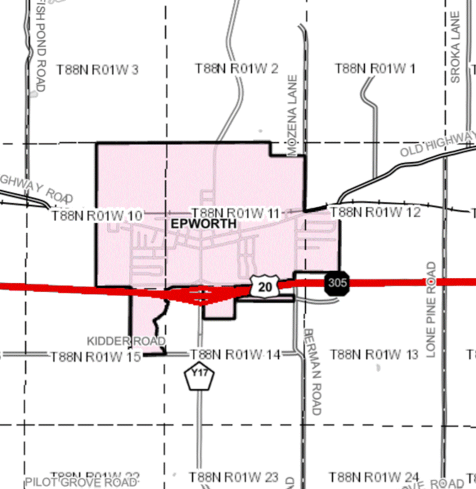
Epworth:
Beginning at the west
corporation line; thence east to the east corporation line.
Beginning again at the
east corporation line of Epworth; thence east through Section 14-T88N-R1W to
the west corporation line of Epworth.
Beginning at the west
corporation line; thence east and northeasterly to the east corporation line.
Beginning again at the
east corporation line of Epworth; thence continuing in an easterly direction
through Sections 14, and 13‑T88N‑R1W; thence continuing in an
easterly direction through the south part of Section 12‑T88N‑R1W
and Sections 7, 8, 9, and 10‑T88N‑R1E; and east following
substantially the section line of sections 15, 14, and 13‑T88N‑R1E
to a point approximately 1,500 feet west of the NE Corner of Section 13‑T88N‑R1E;
thence curving in a northeasterly direction through Section 12‑T88N‑R1E
and continuing northeasterly, northerly, and northeasterly through Sections 7
and 6‑T88N‑R2E to the west corporation line of Dubuque connecting
with Dodge Street., and Sections 31, 32, and 29‑T89N‑R2E to the
west corporation line of Dubuque connecting with Dodge Street.
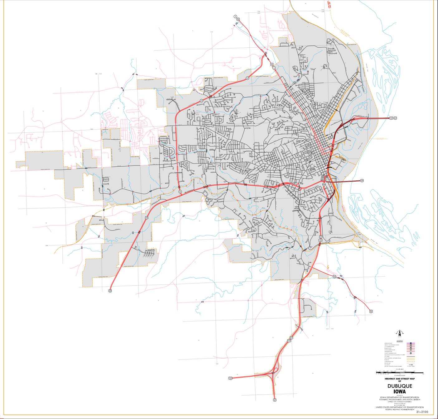
Dubuque:
Beginning on Dodge Street
at the west corporation line; thence northeast and easterly on Dodge Street
(junction Iowa 32) and (junction Iowa 946) to the east corporation line at the
Iowa‑Illinois state line on the Julien‑Dubuque Bridge over the
Mississippi River.
OFFICIAL
DESCRIPTION CHANGE
COUNTY: Dubuque
ROUTE: US 20
STAFF
ACTION NUMBER: S‑87‑718
APPROVAL
DATE: 12‑18‑86
New
Description ‑ US 20 and its extensions in Dubuque County
described as follows:
Beginning
on the Dubuque‑Delaware County line at a point near the NW Corner Section
6‑T88N‑R2W, Dubuque County (NE Corner Section 1‑T88N‑R3W,
Delaware County); thence in an easterly and southeasterly direction through
Section 6‑T88N‑R2W to the west corporation line of Dyersville connecting
with an unnamed street.
Dyersville:
Beginning
on an unnamed street at the west corporation line; thence easterly on unnamed
street to the east corporation line.
Beginning
again at the east corporation line of Dyersville connecting with an unnamed
street; thence east and southeast through Sections 5, 4, and 3‑T88N‑R2W
to a point approximately 535 feet north and 770 feet east of the W ¼ Corner of
Section 3‑T88N‑R2W on the south side of the Illinois Central
Railroad; thence southeast along the south side of said railroad and
substantially parallel thereto through Sections 3, 2, 11, and 12‑T88N‑R2W
to the west corporation line of Farley, connecting with an unnamed street.
Farley:
Beginning
on an unnamed street at the west corporation line; thence southeasterly,
easterly, and northeasterly on unnamed street to the east corporation line.
Beginning again on the
east corporation line of Farley connecting with an unnamed street; thence east
following substantially the section line of Sections 17, 16, 15, 14, and 13‑T88N‑R1W;
thence continuing in an easterly direction through the south part of Section 12‑T88N‑R1W
and Sections 7, 8, 9, and 10‑T88N‑R1E; and east following
substantially the section line of sections 15, 14, and 13‑T88N‑R1E
to a point approximately 1,500 feet west of the NE Corner of Section 13‑T88N‑R1E;
thence curving in a northeasterly direction through Section 12‑T88N‑R1E
and continuing northeasterly, northerly, and northeasterly through Sections 7
and 6‑T88N‑R2E, and Sections 31, 32, and 29‑T89N‑R2E to
the west corporation line of Dubuque connecting with Dodge Street.
Dubuque:
Beginning on Dodge Street at the
west corporation line; thence northeast and easterly on Dodge Street to the east corporation line
at the Iowa‑Illinois state line on the Julien‑Dubuque Bridge over
the Mississippi River.
Durango:
Beginning on an unnamed
street at the west corporation line; thence easterly, northeasterly and easterly
an unnamed street to the east corporation line.
Beginning again on the
east corporation line of Durango, connecting with an unnamed street; thence in
an easterly and southeasterly direction through Sections 31 and 32‑T90N‑R2E
and Section 5‑T89N‑R2E to a point approximately 700 feet south and
700 feet west of the NE Corner of Section 5‑T89N‑R2E; thence in a
northeasterly and southeasterly direction through Section 5‑T89N‑R2E
and Sections 33 and 34‑T90N‑R2E and in a southeasterly direction
through Sections 3, 2, and 11‑T89N‑R2E to the north corporation
line of Dubuque, connecting with Central Avenue.
Dubuque:
Beginning on Central Avenue at
the north corporation line; thence southeasterly on Central Avenue to 21st Street (begin one‑way
southbound); thence continuing southeasterly on Central Avenue to 5th Street; thence
southwesterly on 5th Street
to Bluff Street; thence southeasterly on Bluff Street to Dodge Street (US 20) (end one‑way
southbound).
Also
with a spur
Beginning
at the intersection of Dodge and Locust Street; thence northerly (one‑way
northbound) and Locust Street
to 4th Street; thence easterly on 4th
Street to White Street; thence northwesterly on White Street to 21st
Street; thence southwesterly on 21st
Street to Central Avenue (end one‑way
northbound).
COMMISSION
ORDER
DIVISION: Planning & Research
COMMISSION
ORDER NUMBER: PR‑80‑375
SUBMITTED
BY: Leland D. Smithson
MEETING
DATE: 1‑8‑90
DISCUSSION/BACKGROUND:
US
20 begins at the Dubuque‑Delaware County line near the southwest edge of
Dyersville and travels in a southeasterly, easterly, and northeasterly
direction to the Iowa‑Illinois State line in Dubuque via Dyersville and
Farley.
Due
to an involuntary annexation to the City of Dubuque extending the corporation
line westerly and southerly the present description of US 20 in Dubuque County
should be revised. The new description
added should be officially included in the primary road system to reflect this
change in corporate limits.
PROPOSAL/ACTION
RECOMMENDATION:
It
is recommended that the present description of US 20 in Dubuque County be deleted and the new
description, as referred to in the attached detailed description, be included
in the primary road system.
Locate
US 20 and its extensions in Dubuque
County as follows:
Beginning on the Dubuque‑Delaware
County line at a point near the NW Corner Section 6‑T88N‑R2W,
Dubuque County (NE Corner Section 1‑T88N‑R3W, Delaware County);
thence in an easterly and southeasterly direction through Section 6‑T88‑R2W
to the west corporation line of the City of Dyersville connecting with an
unnamed street.
Dyersville:
Beginning
at the west corporation line connecting with an unnamed street; thence easterly
to the east corporation line, connecting with an unnamed street.
Beginning
again at the east corporation line of the City of Dyersville connecting with an
unnamed street; thence in an easterly and southeasterly direction through
Sections 5, 4, and 3‑T88N‑R2W to a point approximately 535 feet
north and 770 feet east of the W ¼ Corner of Section 3‑T88N‑R2W, on
the south side of the Illinois Central Railroad; thence in a southeasterly
direction along the south side of said railroad and substantially parallel
thereto through Sections 3, 2, 11, and 12‑T88N‑R2W to the west
corporation line of the City of Farley, connecting with an unnamed street.
Farley:
Beginning
at the west corporation line connecting with an unnamed street; thence
southeasterly, easterly, and northeasterly to the east corporation line
connecting with an unnamed street.
Beginning
again on the east corporation line of the City of Farley connecting with an
unnamed street; thence easterly following substantially the section line of
Sections 17, 16, 15, 14, and 13‑T88N‑R1W; easterly through the south
part of Section 12‑T88N‑R1W and Sections 7, 8, 9 and 10‑T88N‑R1E;
and easterly following substantially the section line of Sections 15, 14, and
13‑T88N‑R1E to a point approximately 1500 feet west of the NE
Corner of Section 13‑T88N‑R1E; thence curving in a northeasterly
direction through Section 12‑T88N‑R1E and continuing northeasterly,
northerly, and northeasterly through Sections 7 and 6‑T88N‑R2E, and
Sections 31, 32, and 29‑T89N‑R2E to the west corporation line of
the City of Dubuque connecting with an unnamed street.
Dubuque:
Beginning
at the west corporation line connecting with an unnamed street; thence easterly
to the east corporation line at the Iowa‑Illinois State line.
COMMISSION ORDER
DIVISION: Planning & Research
COMMISSION
ORDER NUMBER: PR‑77‑172
SUBMITTED
BY: C.I. MacGillivray
MEETING
DATE: 11‑2‑78
DISCUSSION/BACKGROUND:
Due
to a review of our Primary Road System records, US 20 in Dubuque County should be deleted and the new
description added should be officially included into the Primary Road System.
US
20 begins at the Dubuque‑Delaware County line near the southwest edge of
Dyersville traveling in a southeasterly, easterly, and northeasterly direction
to the Iowa‑Illinois State line in Dubuque via Dyersville and Farley,
Iowa.
PROPOSAL/ACTION
RECOMMENDATION:
Locate
US 20 and its extensions in Dubuque
County as follows:
Beginning
on the Dubuque‑Delaware County line at a point near the NW Corner Section
6‑T88N‑R2W, Dubuque County (NE Corner Section 1‑T88N‑R3W,
Delaware County): thence in an easterly and southeasterly direction through
Section 6‑T88‑R2W to the west corporation line of the City of
Dyersville connecting with an unnamed street.
Dyersville:
Beginning
at the west corporation line connecting with an unnamed street; thence easterly
to the east corporation line, connecting with an unnamed street.
Beginning again at the
east corporation line of the City of Dyersville connecting with an unnamed
street; thence in an easterly and southeasterly direction through Sections 5,
4, and 3‑T88N‑R2W to a point approximately 535 feet north and 770
feet east of the W ¼ Corner of Section 3‑T88N‑R2W, on the south
side of the Illinois Central Railroad; thence in a southeasterly direction
along the south side of said railroad and substantially parallel thereto
through Sections 3, 2, 11, and 12‑T88N‑R2W to the west corporation
line of the City of Farley, connecting with an unnamed street.
Farley:
Beginning
at the west corporation line connecting with an unnamed street; thence
southeasterly, easterly, and northeasterly to the east corporation line
connecting with an unnamed street.
Beginning
again on the east corporation line of the City of Farley connecting with an
unnamed street; thence easterly following substantially the section line of
Sections 17, 16, 15, 14, and 13‑T88N‑R1W, and Sections 18, 17, 16,
15, 14, and 13‑T88N‑R1E to a point approximately 1500 feet west of
the NE Corner of Section 13‑T88N‑R1E; thence curving in a
northeasterly direction through Section 12‑T88N‑R1E and continuing
northeasterly, northerly, and northeasterly through Sections 7 and 6‑T88N‑R2E,
and Sections 31, 32, 29, and 28‑T89N‑R2E to a point approximately
1,650 feet east and ¼ mile north of the SW Corner Section 28‑T89N‑R2E;
thence in a northeasterly and easterly direction through Section 23‑T89N‑R2E
to the west corporation line of the City of Dubuque connecting with an unnamed
street.
Dubuque:
Beginning
at the west corporation line connecting with an unnamed street; thence easterly
to the east corporation line at the Iowa‑Illinois State line.
NOW,
THEREFORE: Be it resolved that the Iowa Department of Transportation approve
the location of US 20, Dubuque‑County, Iowa.
NOTE:
To become effective upon the adoption of this resolution.
COMMISSION ORDER
DIVISION: Planning & Research
SUBMITTED
BY: Raymond L. Kassel
MEETING
DATE: 10‑5‑76
DISCUSSION/BACKGROUND:
Due
to a review of our Primary Road System records, US 20 in Dubuque County should be deleted and the new
description added should be officially included into the Primary Road System.
US
20 begins at the Dubuque‑Delaware County line near the southwest edge of
Dyersville traveling in a southeasterly, easterly, and northeasterly direction
to the Iowa‑Illinois State line in Dubuque via Dyersville and Farley,
Iowa.
PROPOSAL/ACTION
RECOMMENDATION:
Locate
US 20 and its extensions in Dubuque
County as follows:
Beginning
on the Dubuque‑Delaware County line at a point near the NW Corner Section
6‑T88N‑R2W, Dubuque County (NE Corner Section 1‑T88N‑R3W,
Delaware County); thence in an easterly and southeasterly direction through
Section 6‑T88‑R2W to the west corporation line of the City of
Dyersville connecting with an unnamed street.
Dyersville:
Beginning at the west
corporation line connecting with an unnamed street; thence easterly to the east
corporation line, connecting with an unnamed street.
Beginning
again at the east corporation line of the City of Dyersville connecting with an
unnamed street; thence in an easterly and southeasterly direction through
Sections 5, 4, and 3‑T88N‑R2W to a point approximately 535 feet
north and 770 feet east of the W ¼ Corner of Section 3‑T88N‑R2W, on
the south side of the Illinois Central Railroad; thence in a southeasterly
direction along the south side of said railroad and substantially parallel
thereto through Sections 3, 2, 11, and 12‑T88N‑R2W to the west
corporation line of the City of Farley, connecting with an unnamed street.
Farley:
Beginning at the west
corporation line connecting with an unnamed street; thence southeasterly,
easterly, and northeasterly to the east corporation line connecting with an
unnamed street.
Beginning
again on the east corporation line of the City of Farley connecting with an
unnamed street; thence easterly following substantially the section line of
Sections 17, 16, 15, 14, and 13‑T88N‑R1W, and Sections 18, 17, 16,
15, 14, and 13‑T88N‑R1E to a point approximately 1500 feet west of
the NE Corner of Section 13‑T88N‑R1E; thence curving in a
northeasterly direction through Section 12‑T88N‑R1E and continuing
northeasterly, northerly, and northeasterly through Sections 7 and 6‑T88N‑R2E,
and Sections 31, 32, 29, and 28‑T89N‑R2E to a point approximately
1,650 feet east and ¼ mile north of the SW Corner Section 28‑T89N‑R2E;
thence in a northeasterly and easterly direction through Section 28‑T89N‑R2E
to the west corporation line of the City of Dubuque connecting with an unnamed street.
Dubuque:
Beginning
at the west corporation line connecting with an unnamed street; thence easterly
to the east corporation line at the Iowa‑Illinois State line.
NOW,
THEREFORE: Be it resolved that the Iowa Department of Transportation approve
the location of US 20, Dubuque County,
Iowa.
NOTE:
To become effective upon the adoption of this resolution.
OFFICIAL
DESCRIPTION CHANGE
COUNTY: Dubuque
ROUTE: US 20
APPROVAL
DATE: 4‑2‑58
Beginning
on the Dubuque‑Delaware County line at the SW Corner Section 1‑T89N‑R2W
Dubuque County (SE Corner Section 36‑T89N‑R3W Delaware County); thence
east to a point approximately 394 feet east of the NW Corner Section 6‑T88N‑R2W;
thence curving in a southeasterly and easterly direction through Sections 6 and
5‑T88N‑R2W, and southeasterly through Sections 4 and 3‑T88N‑R2W
to a point approximately 535 feet north and 770 feet east of the W ¼ Corner
Section 3‑T88N‑R2W, on the south side of the Illinois Central
Railroad; thence in a southeasterly direction along the south side of said
railroad and substantially parallel thereto through Sections 3, 2, 11 and 12‑T88N‑R2W
to the west corporation line of the Town of Farley, connecting with an unnamed
street.
Beginning
again on the east corporation line of the Town of Farley, connecting with an
unnamed street; thence easterly following substantially the section line to a
point approximately ½ mile east of the SW Corner Section 12‑T88N‑R1E;
thence curving in a northeasterly direction through said Section 12 and
continuing northeasterly, northerly and northeasterly through Sections 7 and 6‑T88N‑R2E
and Sections 31, 32, 29 and 28‑T89N‑R2E to a point approximately
1,650 feet east and ¼ mile north of the SW Corner Section 28‑T89N‑R2E;
thence in a northeasterly and easterly direction through Sections 28 and 27‑T89N‑R2E
to the west corporation line of the City of Dubuque connecting with Dodge
Street.
Note:
Designation to become effective upon the completion and opening to traffic of
relocation US
20, more specifically project F‑FN‑305.
OFFICIAL
DESCRIPTION CHANGE
COUNTY: Dubuque
CITY
OF:
Farley
ROUTE:
US 20
APPROVAL
DATE: 4‑2‑58
Beginning
on unnamed street at the west corporation line; thence southeasterly, easterly
and northeasterly on unnamed street to the east corporation line.
Note:
Designation to become effective upon the completion & opening to traffic of
relocation US
20, more specifically project F‑FN‑305.
OFFICIAL
DESCRIPTION CHANGE
COUNTY: Dubuque
CITY
OF: Dubuque
ROUTE:
US 20
APPROVAL
DATE: 4‑7‑53
Beginning
on the west corporation line connecting with Dodge Street; thence easterly on Dodge Street to the
east corporation line on the Julien‑Dubuque Bridge over the Mississippi River.