OFFICIAL DESCRIPTION CHANGE
OFFICE: Research and Analytics
EFFECTIVE DATE: 12-31-2013
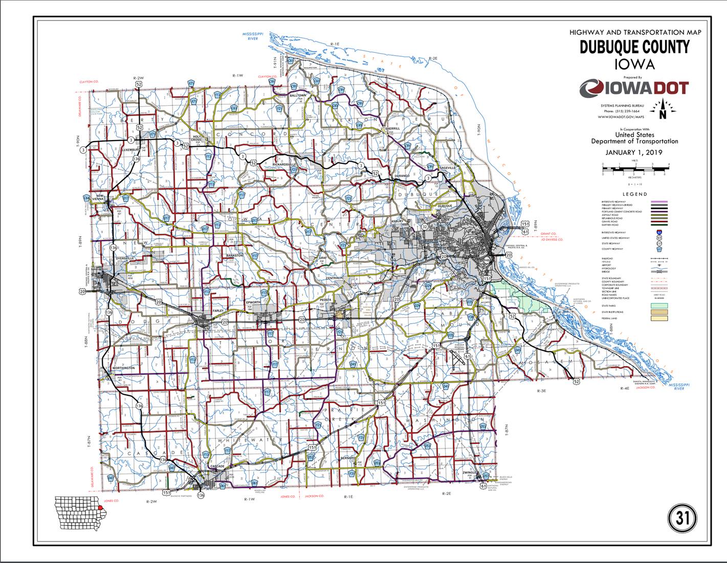
ROUTE: US 151
ENTERED BY: Paul Mauer
ENTERED DATE: 11-21-2019
DISCUSSION/BACKGROUND:
Due
to an annexation by the city of Dubuque in 2013, the official description for
US 151 in the Primary Road System should be revised to reflect this change.
New
Description - US 151 and its extensions in Dubuque County described as follows:
Beginning
on the Dubuque-Jones County line approximately 1060 feet west of the SE Corner
of Section 35-T87N-R2W, Dubuque County (NE Corner of Section 2-T86N-R2W, Jones
County); thence northeasterly through Sections 35 and 36-T87N-R2W to a point
near the NE Corner of Section 36-T87N-R2W; thence northeasterly, easterly,
and northeasterly through Sections 30,
29, 28, 27, 26, 25, and 24-T87N-R1W, Sections 19, 20, 17, 16, 15, 10, 11, 12,
and 1-T87N-R1E, Section 6-T87N-R2E, and Sections 31, 32, 29, 28, 21, and
22-T88N-R2E to the east corporation of Dubuque; a point approximately 2500 feet
south of the NW Corner of Section 23-T88N-R2E.
Dubuque:
Beginning
at the east corporation line; thence east to the junction of US 61; thence
northeasterly, north and northeasterly to the north corporation line.
Beginning
again at the north corporation line of Dubuque; approximately 1,850 feet east
of the SW Corner of Section 1-T88N-R2E; thence northeast to the south
corporation line of Dubuque.
Dubuque:
Beginning
at the south corporation line; continuing northeasterly to the north
corporation line; approximately 300 feet southwest of the junction of US 52.
Beginning
again at the north corporation line; approximately 300 feet southwest of the
junction of US 52; continuing northeasterly through Section 1-T88N-R2E
(junction US 52) to the south corporation line of Dubuque connecting with
Kerrigan Road.
Dubuque:
Beginning
on the south corporation line connecting with Kerrigan Road; thence northerly
on Kerrigan Road to South Locust Street; thence northeasterly on Kerrigan Road
to East 7th Street; thence northerly, northeasterly, and easterly on US 61 to
the east corporation line at the Iowa-Wisconsin State line.
STAFF ACTION
OFFICE:
Transportation
Data
STAFF
ACTION NUMBER: S-03-0783
SUBMITTED
BY: Peggi
Knight
SUBMITTAL
DATE: 04-15-2003
DISCUSSION/BACKGROUND:
Transfer
of jurisdiction agreement number 2001-TJ-006, between the City of Cascade and
the Iowa Department of Transportation, transferred that portion of US 151 from
the west corporation line on 1st Avenue West (Jones-Dubuque County line);
thence east and northeast on 1st Avenue West to 1st Avenue East; thence
northeast on 1st Avenue East to the north corporation line to city jurisdiction
on November 4, 2002.
Transfer
of jurisdiction agreement number 2001-TJ-006, between Dubuque County and the
Iowa Department of Transportation, transferred that portion of US 151 from the
north corporation line of Cascade connecting with 1st Avenue East
(approximately 1500 feet south of the NW Corner of Section 32-T87N-R1W); thence
in a northeasterly direction to a point approximately 1960 feet east and 170
feet north of the NW Corner of Section 32-T87N-R1W to county jurisdiction on
November 4, 2002.
PROPOSAL/ACTION
RECOMMENDATION:
It
is recommended that the old description of US 151 and its extensions in Dubuque County be deleted and the new
description be included in the Primary Road System.
New
Description - US 151 and its extensions in Dubuque County
described as follows:
Beginning
on the Dubuque-Jones County line approximately 1060 feet west of the SE Corner
of Section 35-T87N-R2W, Dubuque County (NE Corner of Section 2-T86N-R2W, Jones
County); thence northeasterly through Sections 35 and 36-T87N-R2W to a point
near the NE Corner of Section 36-T87N-R2W; thence northeasterly, easterly,
and northeasterly through Sections 30,
29, 28, 27, 26, 25, and 24-T87N-R1W, Sections 19, 20, 17, 16, 15, 10, 11, 12,
and 1-T87N-R1E, Section 6-T87N-R2E, and Sections 31, 32, 29, 28, 21, 22, and
23-T88N-R2E to a point near the center of the NE ¼ of Section 23-T88N-R2E
(junction US 61); thence in a northeasterly and northerly direction through
Sections 23, 14, and 13-T88N-R2E to the south corporation line of Dubuque
(approximately 1300 feet east of the NW Corner of Section 13-T88N-R2E).
Dubuque:
Beginning
on the south corporation line; thence northerly and northeasterly to the north
corporation line (approximately 1890 feet east and 90 feet south of the NW
Corner of Section 12-T88N-R2E).
Beginning
again on the north corporation line of Dubuque;
thence northeasterly through Sections 12 and 1-T88N-R2E to the south
corporation line of Dubuque
(approximately 670 feet north of the S ¼ Corner of Section 1-T88N-R2E).
Dubuque:
Beginning
on the south corporation line; thence northeasterly to the north corporation
line (approximately 550 feet east and 1400 feet north of the S ¼ Corner of
Section 1-T88N-R2E) (junction US 52).
Beginning
again on the north corporation line of Dubuque; thence in a northerly direction
through Section 1-T88N-R2E to the south corporation line of Dubuque
(approximately 840 feet west and 1370 feet south of the NE Corner of Section
1-T88N-R2E) connecting with Kerrigan Road.
Dubuque:
Beginning
on the south corporation line connecting with Kerrigan Road; thence northerly
on Kerrigan Road to South Locust Street; thence northeasterly on Kerrigan Road
to East 7th Street; thence northerly, northeasterly, and easterly on US 61 to
the east corporation line at the Iowa-Wisconsin State line.
STAFF ACTION
OFFICE:
Transportation
Data
STAFF
ACTION NUMBER: S-96-1248
SUBMITTED
BY: Patrick
R. Cain
SUBMITTAL
DATE: 2-14-96
DISCUSSION/BACKGROUND:
Due
to the relocation of several routes in Dubuque
in 1991, the routing for US 151 was revised and the official description in the
Primary Road System should be revised to reflect this change.
PROPOSAL/ACTION
RECOMMENDATION:
It
is recommended that the old description of US 151 in Dubuque County be deleted from the Primary
Road System and the new description, as described in the attachment, be
included in the Primary Road
system.
New
Description - US 151 and its extensions in Dubuque County
described as follows:
Cascade:
Beginning on 1st Avenue
West at the west corporation line (Dubuque-Jones County line); thence east and
northeast on 1st Avenue West to 1st Avenue East; thence northeast on 1st Avenue
East to the north corporation line.
Beginning
again on the north corporation line of Cascade, connecting with 1st Avenue
East; thence in a northeasterly direction through Sections 31, 32, 29, 28, 27,
26, 25 and 24-T87N-RlW; Sections 19, 20, 17, 16, 15, 10, 11, 12 and
1-T87N-R1E; Section 6-T87N-R2E and Sections 31, 32, 29, 28, 21, 22 and
23-T88N-R2E to a point near the center of the NE ¼ of Section 23-T88N-R2E
(junction US 61); thence in a northeasterly and northerly direction through
Sections 23, 14, 13, 12 and 1-T88N-R2E (junction US 52) to the south
corporation line of Dubuque connecting with Kerrigan Road.
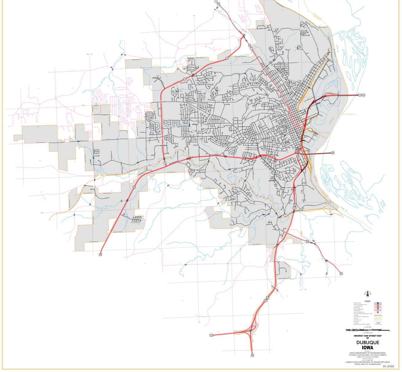
Dubuque:
Beginning on Kerrigan road
at the south corporation line; thence north on Kerrigan Road to South Locust
Street; thence northeast and north on unnamed street to near 3rd Street; thence
northeast (begin one-way northbound) to White Street; thence northwesterly on
White Street to 9th Street; thence easterly and northeasterly on 9th Street to
11th Street; thence easterly on 11th Street to Kerper
Boulevard; thence north on Kerper Boulevard to 16th
Street; thence easterly on 16th Street to unnamed street (end one-way
northbound); thence easterly on 16th Street to east corporation line at the
Iowa-Wisconsin line.
Also
Beginning at the
intersection of 16th Street and unnamed street (begin one-way southbound);
thence westerly on unnamed street to 11th street; thence westerly to Central
Avenue; thence southeasterly on Central Avenue to 4th Street; thence
southwesterly on unnamed street to near 3rd street (end one-way southbound).
STAFF ACTION
OFFICE:
Transportation
Data
STAFF
ACTION NUMBER: S-96-1249
SUBMITTED
BY: Patrick
R. Cain
SUBMITTAL
DATE: 2-26-96
DISCUSSION/BACKGROUND:
Due
to the relocation of several routes in Dubuque in 1992, the routing for US 151 was
revised and the official description in the Primary Road System should be
revised to reflect this change.
At
the same time some of the old route became Unsigned Iowa 948 and Unsigned Iowa
959.
PROPOSAL/ACTION
RECOMMENDATION:
It
is recommended that the old description of US 151 in Dubuque County be deleted from the Primary
Road System and the new description, as described in the attachment, be
included in the Primary Road System.
New
Description - US 151 and its extensions in Dubuque County
described as follows:
Cascade:
Beginning on 1st Avenue
West at the west corporation line (Dubuque-Jones County line); thence east and
northeast on 1st Avenue West to 1st Avenue East; thence northeast on 1st Avenue
East to the north corporation line.
Beginning
again on the north corporation line of Cascade, connecting with 1st Avenue
East; thence in a northeasterly direction through Section 31, 32, 29, 28, 27,
26, 25 and 24-T87N-RlW; Section 19, 20, 17, 16, 15, 10, 11, 12 and 1-T87N-R1E;
Section 6-T87N-R2E and Section 31, 32, 29, 28, 21, 22 and 23-T88N-R2E to a
point near the center of the NE ¼ of Section 23-T88N-R2E (junction US 61);
thence in a northeasterly and northerly direction through Sections 23, 14, 13,
12 and 1-T88N-R2E (junction US 52 to the south corporation line of Dubuque
connecting with Kerrigan Road.
Dubuque:
Beginning on Kerrigan road
at the south corporation line; thence north on Kerrigan Road to South Locust
Street; thence northeast and north on unnamed street to near 3rd Street; thence
northeast (begin one-way northbound) to White Street; thence northwesterly on
White Street to 9th Street; thence easterly and northeasterly on 9th Street to
northbound ramps; thence northbound to unnamed street (end one-way northbound)
then northeasterly and easterly on unnamed street to east corporation line at
the Iowa-Wisconsin line.
Also
Beginning
at the intersection of off ramp and unnamed street (begin one-way southbound);
thence southwesterly on off ramp to 11th Street; thence westerly on Central
Avenue; thence southeasterly on Central Avenue to 4th Street; thence
southwesterly on unnamed street to near 3rd Street (end one-way southbound).
STAFF ACTION
OFFICE:
Transportation
Data
STAFF
ACTION NUMBER: S-96-1275
SUBMITTED
BY: Patrick
R. Cain
SUBMITTAL
DATE: 2-26-96
DISCUSSION/BACKGROUND:
Due
to the relocation of several routes in Dubuque
in 1993, the routing for US 151 was revised and the official description in the
Primary Road System should be revised to reflect this change.
PROPOSAL/ACTION
RECOMMENDATION:
It
is recommended that the old description of US 151 in Dubuque County be deleted from the Primary
Road System and the new description, as described in the attachment, be
included in the Primary Road System.
New
Description - US 151 and its extensions in Dubuque County
described as follows:
Cascade:
Beginning
on 1st Avenue West at the west corporation line (Dubuque-Jones County line);
thence east and northeast on 1st Avenue West to 1st Avenue East; thence
northeast on 1st Avenue East to the north corporation line.
Beginning
again on the north corporation line of Cascade, connecting with 1st Avenue
East; thence in a northeasterly direction through Section 31, 32 29, 28, 27,
26, 25 and 24-T87N-RlW; Section 19, 20, 17, 16, 15, 10, 11, l and 1-T87N-R1E;
Section 6-T87N-R2E and Section 31, 32, 29, 28, 21, 22 and 23-T88N-R2E to a
point near the center of the NE ¼ of Section 23-T88N-R2E (junction US 61);
thence in a northeasterly and northerly direction through Sections 23, 14, 13,
12 and 1-T88N-R2E (junction US 52) to the south corporation line of Dubuque
connecting with Kerrigan Road.
Dubuque:
Beginning on Kerrigan road
at the south corporation line; thence north on Kerrigan Road to South Locust Street;
thence northeasterly, northerly, northeasterly and northerly on unnamed street
to east corporation line at the Iowa-Wisconsin line.
OFFICIAL
DESCRIPTION CHANGE
COUNTY: Dubuque
ROUTE: US 151
STAFF
ACTION NUMBER: S‑87‑718
APPROVAL
DATE: 12‑18‑86
New
Description ‑ US 151 and its extensions in Dubuque County
described as follows:
Cascade:
Beginning
on 1st Avenue West at the west corporation line (Dubuque‑Jones County
line); thence east and northeast on 1st Avenue West to 1st Avenue East; thence
northeast on 1st Avenue East to the north corporation line.
Beginning
again on the north corporation line of Cascade, connecting with 1st Avenue
East; thence in a northeasterly direction through Section 31, 32, 29, 28, 27,
26, 25 and 24‑T87N‑R1W; Section 19, 20, 17, 16, 15, 10, 11, 12 and
1‑T87N‑R1E; Section 6‑T87N‑R2E and Section 31, 32, 29,
28, 21, 22 and 23‑T88N‑R2E to a point near the center of the NE ¼
of Section 23‑T88N‑R2E (junction US 61); thence in a northeasterly
and northerly direction through Sections 23, 14, 13, 12 and 1‑T88N‑R2E
(junction US 52) to the south corporation line of Dubuque connecting with
Kerrigan Road.
Dubuque:
Beginning
on Kerrigan Road at the south corporation line; thence northerly on Kerrigan
Road to South Locust Street; thence northerly on South Locust Street to Locust
Street (junction US 20); thence northerly (begin one‑way northbound) on
Locust Street to 4th Street; thence easterly on 4th Street to White Street;
thence northerly on White Street to 9th Street; thence easterly and
northeasterly on 9th Street to 11th Street (end one‑way northbound);
thence easterly on 11th Street to Kerper Boulevard;
thence north on Kerper Boulevard to 16th Street;
thence easterly on 16th Street to the east corporation line at the Iowa‑Wisconsin
state line.
Also
with a spur
Beginning
at the intersection of 9th Street and 11th Street (begin one‑way
southbound); thence westerly on 11th Street to Central Avenue; thence southeast
on Central Avenue to 5th Street; thence southwest on 5th Street to
Bluff Street; thence southeast and southwest on Bluff Street to Dodge Street
(junction US 20) (end one‑way southbound).
STAFF
ACTION
OFFICE: Transportation Inventory
STAFF
ACTION NUMBER: S‑83‑777
SUBMITTED
BY: Patrick R. Cain
APPROVAL
DATE: 2‑17‑83
DISCUSSION/BACKGROUND:
US
151 begins at the Dubuque‑Jones County line at Cascade and travels
northeasterly via the Cities of Cascade and Dubuque
to the Iowa‑Wisconsin State line at the City of Dubuque.
Since
the new City Island Bridge is now open to traffic and US 151 traffic is being
routed over a temporary connection via Dubuque city streets across the City
Island Bridge to the State of Wisconsin, the official description of US 151
should be revised to reflect this change.
PROPOSAL/ACTION
RECOMMENDATION:
It
is recommended to approve deleting the present description of US 151 in Dubuque County from the
primary road system and approve including the attached new description of US
151 in the primary road system.
Locate
US 151 and its extensions in Dubuque
County as follows:
Cascade:
Beginning
on an unnamed street on the Dubuque‑Jones County line; thence in a
northeasterly direction to the north corporation line connecting with an
unnamed street.
Beginning
again on the north corporation line of the City of Cascade, connecting with an
unnamed street; thence in a northeasterly direction through Section 31, 32, 29,
28, 27, 26, 25 and 24‑T87N‑R1W; Section 19, 20, 17, 16, 15, 10, 11;
12 and 1‑T87N‑R1E; Section 6‑T87N‑R2E and Section 31,
32, 29, 28, 21, 22 and 23‑T88N‑R2E to a point near the center of
the NE ¼ of Section 23‑T88N‑R2E (junction US 61); thence in a
northeasterly and northerly direction through Sections 23, 14, 13, 12 and 1‑T88N‑R2E
(junction US 52) to the south corporation line of the City of Dubuque
connecting with an unnamed street.
Dubuque:
Beginning
at the south corporation line connecting with an unnamed street; thence
generally northerly, northeasterly and northwesterly to Ninth Street; thence in a northeasterly,
northwesterly and northeasterly direction over a temporary connection on city
streets to the City Island Bridge;
thence northeasterly to the Iowa‑Wisconsin State line on the City Island
Bridge.
Also
with a spur
With
a temporary connection over city streets from the intersection of Eleventh
Street and Kerper Boulevard southwesterly to Central
Avenue; thence beginning at the intersection of Eleventh Street and Central
Avenue (begin one‑way southbound); thence southeasterly, southwesterly
and southeasterly to Dodge Street (end one‑way southbound).
REVISED:
12‑18‑86
COMMISSION ORDER
DIVISION: Planning
& Research
COMMISSION
ORDER NUMBER: PR‑79‑272
SUBMITTED
BY: C.I. MacGillivray
MEETING
DATE: 11‑2‑78
DISCUSSION/BACKGROUND:
Due
to a review of our Primary Road System records US
151 in Dubuque County should be deleted and the new
description added should be officially included into the Primary System.
US
151 begins on the Dubuque‑Jones County line in Cascade and travels
generally northeasterly to Iowa‑Wisconsin State line in Dubuque, Iowa.
PROPOSAL/ACTION
RECOMMENDATION:
Locate
US 151 and its extensions in Dubuque
County as follows:
Cascade:
Beginning
on an unnamed street on the Dubuque‑Jones County line; thence in a
northeasterly direction to the north corporation line connecting with an
unnamed street.
Beginning
again on the north corporation line of the City of Cascade, connecting with an
unnamed street; thence in a northeasterly direction through Section 31, 32, 29,
28, 27, 26, 25 and 24‑T87N‑R1W; Section 19, 20, 17, 16, 15, 10, 11,
12 and 1‑T87N‑R1E; Section 6‑T87N‑R2E and Section 31,
32, 29, 28, 21, 22 and 23‑T88N‑R2E to a point near the center of
the NE ¼ of Section 23‑T88N‑R2E (junction US 61); thence in a
northeasterly and northerly direction through Sections 23, 14, 13, 12 and 1‑T88N‑R2E
(junction US 52) to the south corporation line of the City of Dubuque
connecting with an unnamed street.
Dubuque:
Beginning
at the south corporation line connecting with an unnamed street; thence
generally northerly, northeasterly, northwesterly and northeasterly to the east
corporation line on the Dubuque‑Wisconsin Bridge over the Mississippi River.
Also
with a spur
Beginning
at the intersection of Central
Avenue and East 20th Street (begin one way
southbound); thence southeasterly, southwesterly, and southeasterly to Dodge Street (end of
one way southbound).
NOW,
THEREFORE: Be it resolved that the Iowa
Department of Transportation approve the location of US 151 in Dubuque
County, Iowa.
NOTE: To become effective upon the adoption of this
resolution.
REVISED:
2‑17‑83
COMMISSION RESOLUTION
DIVISION: Planning & Research
COMMISSION
ORDER NUMBER: 73‑137
SUBMITTED
BY: Gene R. Mills
MEETING
DATE: 2‑7‑73
Locate
US 151 in Dubuque
County as follows:
Beginning
on the north corporation line of the Town of Cascade, connecting with National
Street; thence in a northeasterly direction through Section 31, 32, 29, 28, 27,
26, 25 and 24‑T87N‑R1W, Section 19, 20, 17, 16, 15, 10, 11, 12 and
1‑T87N‑R1E, Section 6‑T87N‑R2E and Section 31, 32, 29,
28, 21, and 22 to a point approximately center of NE ¼ Section 23‑T88N‑R2E;
thence in a northeasterly and northerly direction through Section 14, 13, 12
and 1‑T88N‑R2E to the south corporation line of the City of
Dubuque, connecting with Kerrigan Road.
NOW,
THEREFORE: Be it resolved that the Iowa
State Highway Commission approve the revision of US 151 in Dubuque
County, Iowa.
NOTE: The following sections of old US 151 will
revert to the Dubuque County Secondary Road System in accordance with section
313.2 Code of Iowa:
Station
38+34 to Station 113+56
Station
142+05 to Station 203+54
Station
225+54 to Station 303+79
Station
356+18 to Station 390+07
Station
499+61 to Station 581+89
Station
627+42 to Station 654+66
Station
676+34 to Station 747+25
Station
768+08 to Station 778+63
Station
887+69 (Equation 1059+25=) to Station 37+90 (0+00)
OFFICIAL
DESCRIPTION CHANGE
COUNTY: Dubuque
ROUTE: US 151
APPROVAL
DATE: 2‑7‑73
Beginning
on the Dubuque‑Jones County line at a point approximately 500 feet west
of the S ¼ Corner Section 36‑T87N‑R2W, Dubuque County (N ¼ Corner
Section 1‑T86N‑R2W, Jones County); thence east along the Dubuque‑Jones
County line to the west corporation line of the Town of Cascade connecting with
Main Street.
Beginning
again on the north corporation line of the Town of Cascade, connecting with
National Street; thence in a northeasterly direction through Section 31, 32,
29, 28, 27, 26, 25 and 24‑T87N‑R1W, Section 19, 20, 17, 16, 15, 10,
11, 12 and 1‑T87N‑R1E, Section 6‑T87N‑R2E and Section
31, 32, 29, 28, 21, and 22 to a point approximately center of NE ¼ Section 23‑T88N‑R2E;
thence in a northeasterly and northerly direction through Section 14, 13, 12
and 1‑T88N‑R2E to the south corporation line of the City of Dubuque.
OFFICIAL DESCRIPTION CHANGE
COUNTY:
Dubuque
CITY
OF:
Cascade
ROUTE:
US 151
APPROVAL
DATE: 3‑17‑65
Commencing
on Main Street at the west corporation line; thence easterly on Main Street to
National Street; thence northeasterly on National Street to the north
corporation line.
OFFICIAL
DESCRIPTION CHANGE
COUNTY: Dubuque
CITY
OF: Dubuque
ROUTE: US 151
APPROVAL
DATE: 10‑2‑57
Commencing
on an unnamed street at the south corporation line; thence northerly on said
unnamed street to Rockdale Road at a point approximately a mile north of the
intersection of Rockdale Road and Grandview Avenue; thence northerly on
Rockdale Road, South Locust and Locust Streets to 4th Street; thence easterly
on 4th Street to Central Avenue; thence northwesterly on Central
Avenue to 20th Street; thence northeasterly on 20th Street to Rhomberg Avenue; thence northeasterly on Rhomberg Avenue to the east corporation line on the Dubuque‑Wisconsin
Bridge over the Mississippi River.
OFFICIAL
DESCRIPTION CHANGE
COUNTY:
Dubuque
CITY
OF: Dubuque
ROUTE:
US 151
APPROVAL
DATE: 10‑2‑57
Beginning
on Kerrigan Road at the south corporation line; thence northerly on Kerrigan
Road to South Locust Street; thence northerly on South Locust and Locust
Streets to 4th Street; thence easterly on 4th Street to Central Avenue; thence
northwesterly on Central Avenue to 20th Street; thence northeasterly on 20th
Street to Rhomberg Avenue; thence northeasterly on Rhomberg Avenue to the east corporation line on the Dubuque‑Wisconsin
Bridge over the Mississippi River.
OFFICIAL DESCRIPTION CHANGE
COUNTY: Dubuque
ROUTE:
US 151
APPROVAL
DATE: 10‑2‑57
Beginning
on the Dubuque‑Jones County line at a point approximately 500 feet west
of the S ¼ Corner Section 36‑T87N‑R2W, Dubuque County (N ¼ Corner
Section 1‑T86N‑R2W, Jones County); thence east along the Dubuque‑Jones
County line to the west corporation line of the Town of Cascade connecting with
Main Street.
Beginning
again on the north corporation line of the Town of Cascade, connecting with
National Street; thence in a northeasterly direction through Section 31, 32,
29, 28, 27, 26 and 25‑T87N‑R1W, Section 30, 19, 20, 17, 16, 15, 14,
11, 12 and 1‑T87N‑R1E, Section 6‑T87N‑R2E Section 31,
32, 29, 28, 21, 22, 15, 14, 11 and 12‑T88N‑R2E to a point
approximately ¼ mile east and 700 feet south of the NW Corner Section 12‑T88N‑R2E;
thence in a northeasterly and northerly direction through Sections 12 and 1‑T88N‑R2E
to the south corporation line of the City of Dubuque, connecting with Kerrigan
Road.