OFFICIAL
DESCRIPTION CHANGE
OFFICE:
Research and Analytics
EFFECTIVE
DATE: 10-30-2019
COUNTY:
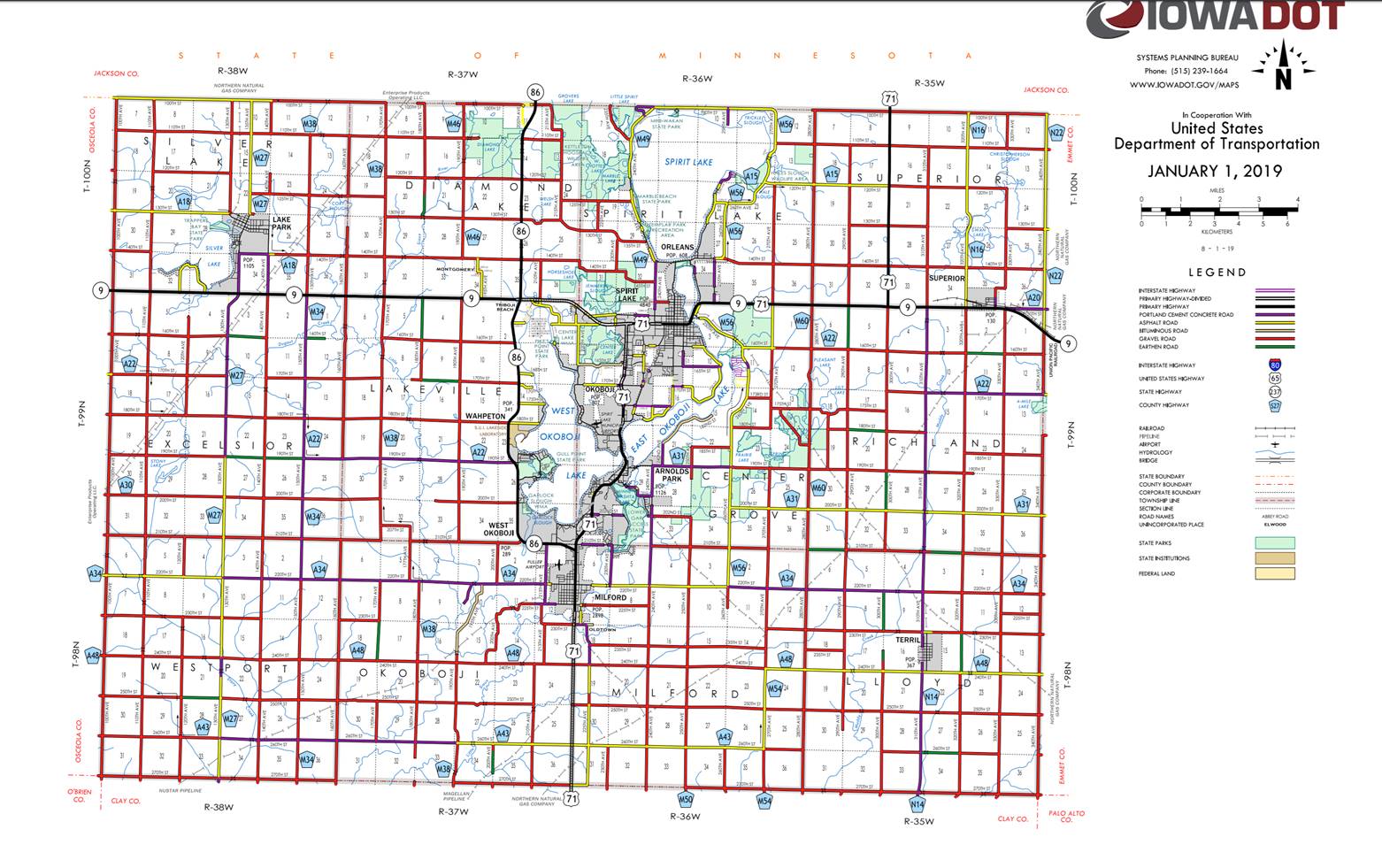
Dickinson
ROUTE:
Iowa 86
ENTERED
BY: Paul Mauer
ENTERED
DATE: 10-30-2019
New
Description ‑ Iowa 86 and its extension
in Dickinson County described as follows:
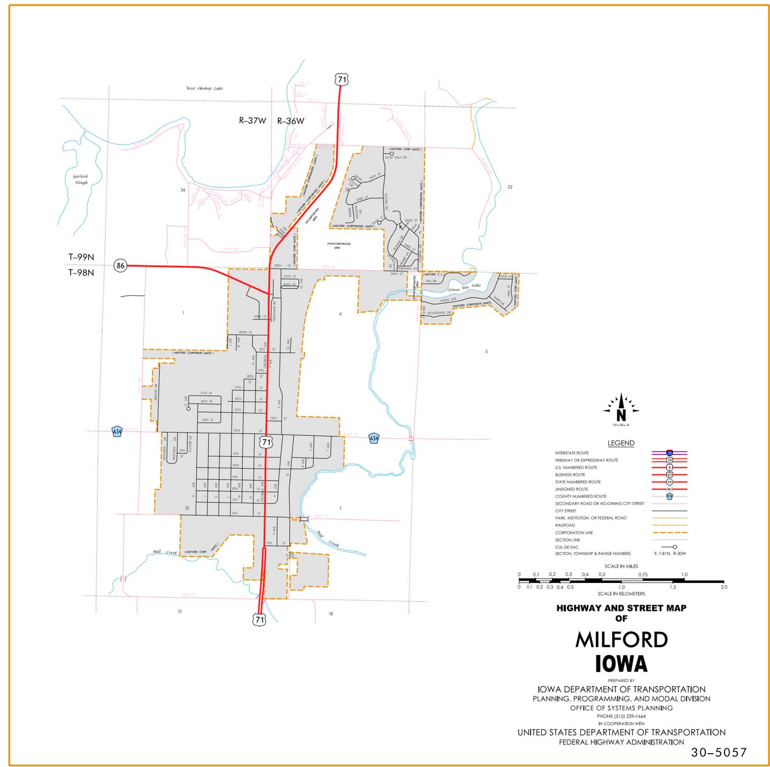
Milford:
Beginning at the junction of US 71 (approximately 400 feet
south of the NE Corner of Section 1‑T98N‑R37W); thence northwesterly to the west
corporation line.
Beginning again at the west corporation line of
Milford curving northwesterly through Section 1-T98N-R37W to the south
corporation line of West Okoboji.
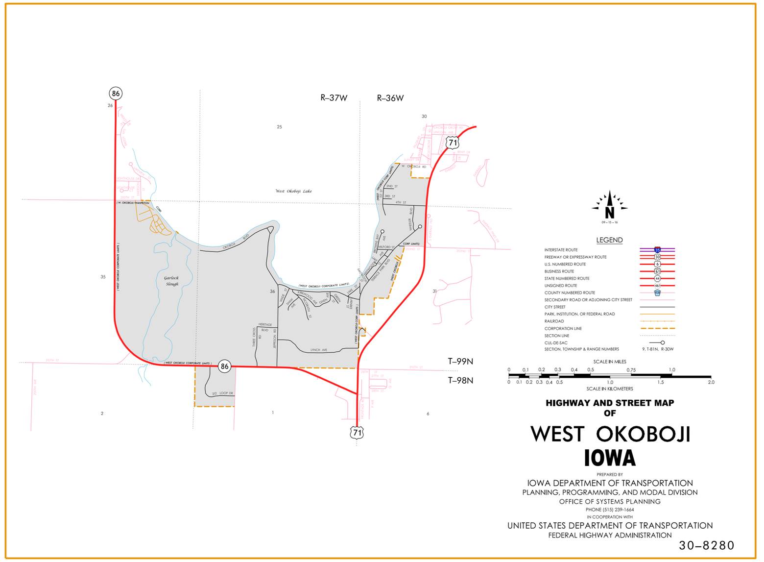
West Okoboji:
Beginning at the south corporation line; thence
west, northwest and north to the north corporation line and south corporation
line of Wahpeton.
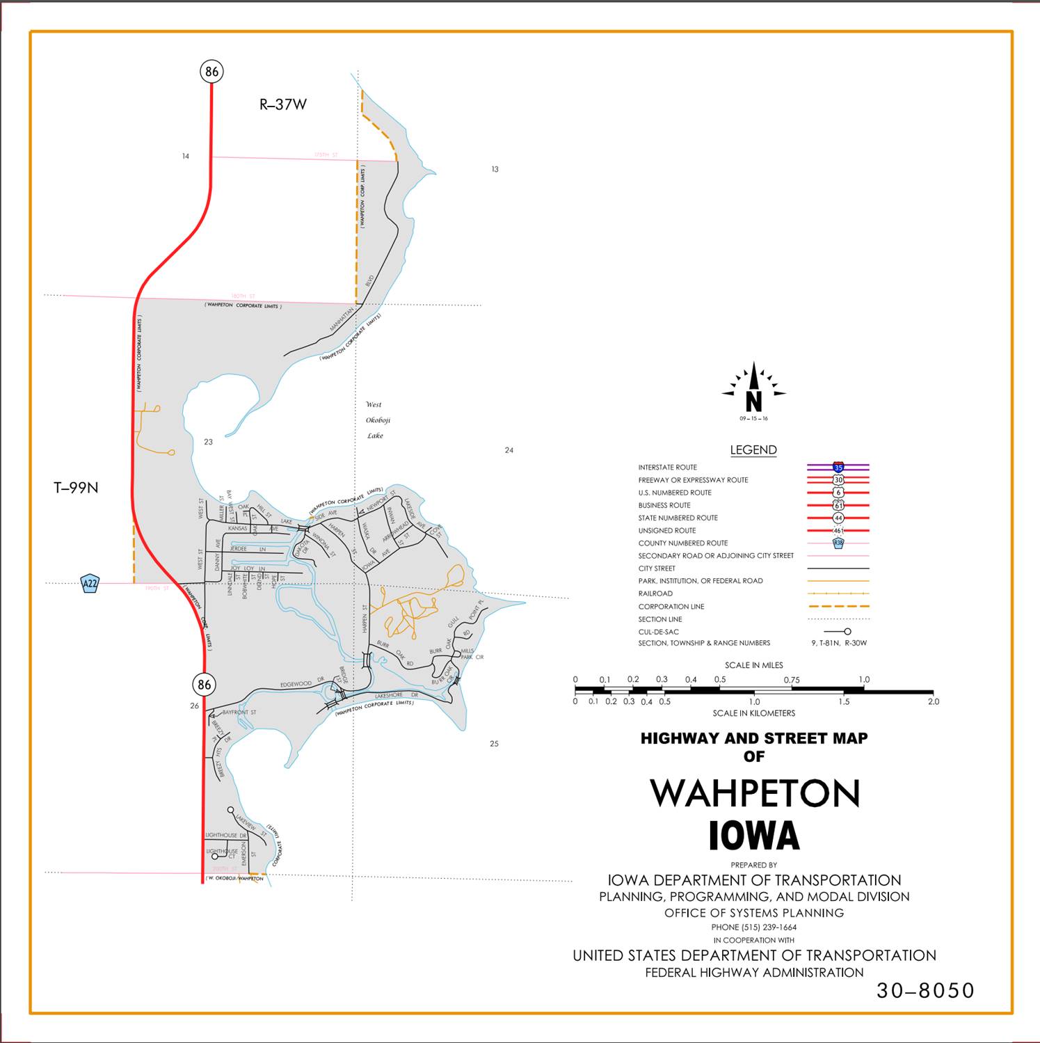
Wahpeton:
Beginning
at the south corporation line; thence northwesterly and north to the north
corporation line.
Beginning
again on the north corporation line of Wahpeton; thence in a northerly
direction through Sections 14, 11 and 2‑T99N‑R37W to a point near
the N ¼ Corner of Section 2‑T99N‑R37W (junction Iowa 9); thence
north following substantially the center section line of Sections 35, 26, 23,
14-T100N-R37W; thence curving in a northeasterly direction to a point
approximately to a point approximately 1,100 feet east of the N ¼ Corner
Section 11‑T100N‑R37W on the Iowa‑Minnesota State line.
OFFICIAL
DESCRIPTION CHANGE
COUNTY: Dickinson
ROUTE: Iowa
86
STAFF
ACTION NUMBER: S-87-703
APPROVAL
DATE: 12-18-86
New
Description ‑ Iowa 86 and its extension
in Dickinson County described as follows:
Beginning
at a point approximately 400 feet south of the NE Corner of Section 1‑T98N‑R37W
(junction US 71); thence curving in a northwesterly direction to a point
approximately 400 feet west of the NE Corner of Section 1‑T98N‑R37W;
thence westerly following substantially the section line of Sections 1 and 2‑T98N‑R37W
to a point approximately 950 feet west of the NW Corner Section 2‑T98N‑R37W;
thence northwesterly and northerly through Sections 35 and 26-T99N-R37W to the
south corporation line of Wahpeton, connecting with an unnamed street.
Wahpeton:
Beginning
on an unnamed street at the south corporation line; thence northwesterly on
unnamed street to the west corporation line.
Beginning
again on the west corporation line of Wahpeton, connecting with an unnamed street;
thence in a northwesterly direction through Section 23‑T99N‑R37W to
a point approximately one‑quarter mile east and one‑quarter mile
north of the SW Corner of Section 23‑T99N‑R37W; thence in a
northerly direction through Sections 23, 14, 11 and 2‑T99N‑R37W to
a point near the N ¼ Corner of Section 2‑T99N‑R37W (junction Iowa
9); thence north following substantially the center section line of Sections
35, 26, 23, 14 and 11‑T100N‑R37W to a point approximately 264 feet
south of the N ¼ Corner Section 11‑T100N‑R37W; thence curving in a
northeasterly direction to a point approximately 264 feet east of the N ¼
Corner Section 11‑T100N‑R37W on the Iowa-Minnesota State line;
thence east following substantially the Section line of Section 11‑T100N‑R37W
along the Iowa‑Minnesota State line to a point approximately 1,100 feet
east of the N ¼ Corner Section 11‑T100N‑R37W on the Iowa‑Minnesota
State line.
COMMISSION
ORDER
DIVISION: Planning & Research
COMMISSION
ORDER NUMBER:
PR-81-418
SUBMITTED
BY: Patrick R. Cain
MEETING
DATE:
1-6-81
DISCUSSION/BACKGROUND:
Transfer
of jurisdiction agreement number TJ‑000‑0 (1)‑‑2M‑30,
between Dickinson County and the Iowa Department of Transportation, transferred
the section of road from a junction with Iowa 9 and 32 near the S ¼ Corner
Section 35‑T100N‑R37W north and east to the Iowa‑Minnesota
state line approximately 1100 feet east of the N ¼ Corner Section 11‑T100N‑R37W
to state jurisdiction on July 1, 1980.
The section is now designated Iowa
86.
To
maintain continuity in the Iowa route numbering system Iowa 32 from a junction
with US 71 approximately 400 feet south of the NE Corner of Section 1‑T98N‑R37W
west and north to a junction with Iowa 9 near the N ¼ Corner Section 2‑T99N‑R37W
should be re-designated as a portion of Iowa 86.
Iowa 86 begins at a junction
with US 71 approximately one mile north of the City of Milford and proceeds westerly, northerly and
easterly to the Iowa‑Minnesota state line approximately seven miles
northwest of the City of Spirit Lake.
PROPOSAL/ACTION
RECOMMENDATION:
It
is recommended the commission approve including the attached description of Iowa 86 in Dickinson
County in the primary
road system.
Locate
Iowa 86 and its extension in Dickinson County
as follows:
Beginning
at a point approximately 400 feet south of the NE Corner of Section 1‑T98N‑R37W
(junction US 71); thence curving in a northwesterly direction to a point
approximately 400 feet west of the NE Corner of Section 1‑T98N‑R37W;
thence westerly following substantially the section line of Sections 1 and
2-T98N‑R37W and northwesterly northerly and northwesterly through
Sections 35 and 26-T99N-R37W to the south corporation line of the City of
Wahpeton, connecting with an unnamed street.
Wahpeton:
Beginning
on unnamed street at the south corporation line. Thence northwesterly on unnamed street to the
west corporation line.
Beginning
again on the west corporation line of the City of Wahpeton, connecting with an
unnamed street; thence in a northwesterly direction through Section 23‑T99N‑R37W
to a point approximately one‑quarter mile east and one‑quarter mile
north of the SW Corner of Section 23‑T99N‑R37W; thence in a
northerly direction through Sections 23, 14, 11 and 2‑T99N‑R37W to
a point near the N ¼ Corner of Section 2‑T99N‑R37W (junction Iowa
9); thence in a northerly direction following substantially the center section
line of Sections 35, 26, 23, 14 and 11‑T100N‑R37W to a point
approximately 264 feet south of the N ¼ Corner Section 11‑T100N‑R37W;
thence curving in a northeasterly direction to a point approximately 264 feet
east of the N ¼ Corner Section 11‑T100N‑R37W on the Iowa‑Minnesota
State line; thence easterly following substantially the Section line of Section
11‑T100N‑R37W along the Iowa‑Minnesota State line to a point
approximately 1100 feet east of the N ¼ Corner Section 11‑T100N-R37W on
the Iowa‑Minnesota State line.