OFFICIAL
DESCRIPTION CHANGE
OFFICE:
Research and Analytics
EFFECTIVE
DATE: 08-23-2019
COUNTY:
Dallas
ROUTE:
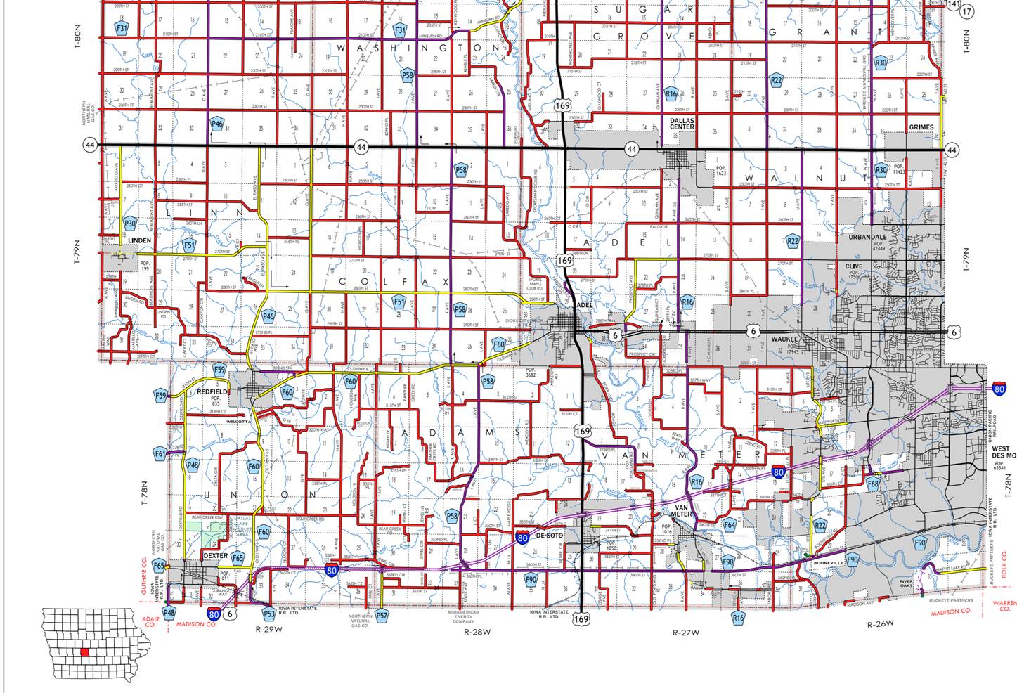
US 6
ENTERED
BY: Paul Mauer
ENTERED
DATE: 08-14-2020

DISCUSSION/BACKGROUND:
Due to annexations by the Cities of Adel and Waukee
effective April 4, 2018 ,August 16, 2017 and August 23, 2019. It is recommended
that the primary route description for US 6 be revised.
New
Description ‑ US 6 and its extensions in Dallas County described as
follows:
Beginning on the Dallas‑Madison County line at a point
approximately 1704 feet west of the SE Corner of Section 32‑T78N‑R29W,
Dallas County (NE Corner of Section 5‑T77N‑R29W, Madison County);
thence northeasterly through Sections 32 and 33‑T73N‑R29W to a
point approximately 2612 feet east and 127 feet south of the N ¼ Corner of
Section 33‑T73N‑R29W; thence easterly following substantially the
section line of Sections 33, 34, 35, and 36‑T78N‑R29W and Sections
31 and 32‑T78N‑R28W to a point approximately 1094 feet west of the
NE Corner of said Section 32; thence northeasterly through Sections 29, 28, 27,
26, 23, and 24‑T78N‑R28W to the west corporation line of De Soto
connecting with an unnamed street (approximately 1869 feet east and 159 feet
north of the Center of said Section 24).
De Soto:
Beginning west corporation line; thence easterly connecting with
Guthrie Street at the junction of US 169; thence northerly on Guthrie Street to
the north corporation line.
Beginning again on the north corporation line of De Soto connecting
with Guthrie Street; thence north following substantially the section line of
Sections 19, 18, 7, and 6‑T78N‑R27W to the south corporation line
of Adel connecting with Nile Kinnick Drive South.
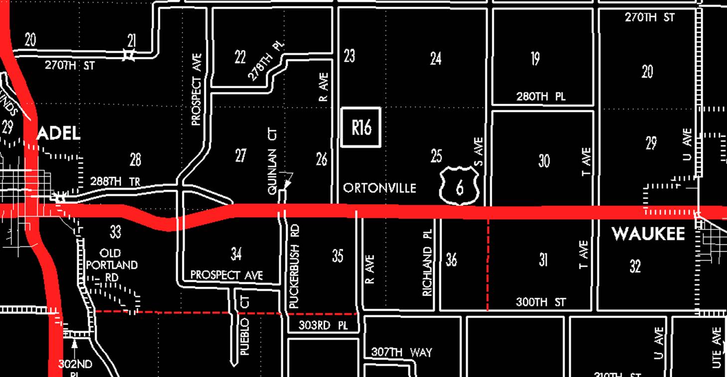
Adel:
Beginning at the south corporation line connecting with Nile
Kinnick Drive South; thence northerly on Nile Kinnick Drive South to the north
corporation line at the intersection of 302nd Place.
Beginning again at the north corporation line of Adel connecting
with Nile Kinnick Drive South; thence northerly to the north corporation line
of Adel connecting with Nile Kinnick Drive South (approximately 70 feet west of
the NW Corner of Section 6-T78N-R27W).
Adel:
Beginning at the south corporation line connecting with Nile
Kinnick Drive South; thence northerly, northwesterly and northerly on Nile
Kinnick Drive South connecting with Greene Street at the Junction of US 169;
thence easterly on Greene Street to the east corporation line at the
intersection of R Avenue (approximately 1.330 feet west of the NW Corner of
Section 35-T79N-R35W).
Beginning again at the east corporation line of Adel at the
intersection of R Avenue (approximately 1.330 feet west of the NW Corner of
Section 35-T79N-R35W); thence easterly to the west corporation line of Waukee
(approximately 1,025 feet west of the NW Corner of Section 35-T79N-R35W).
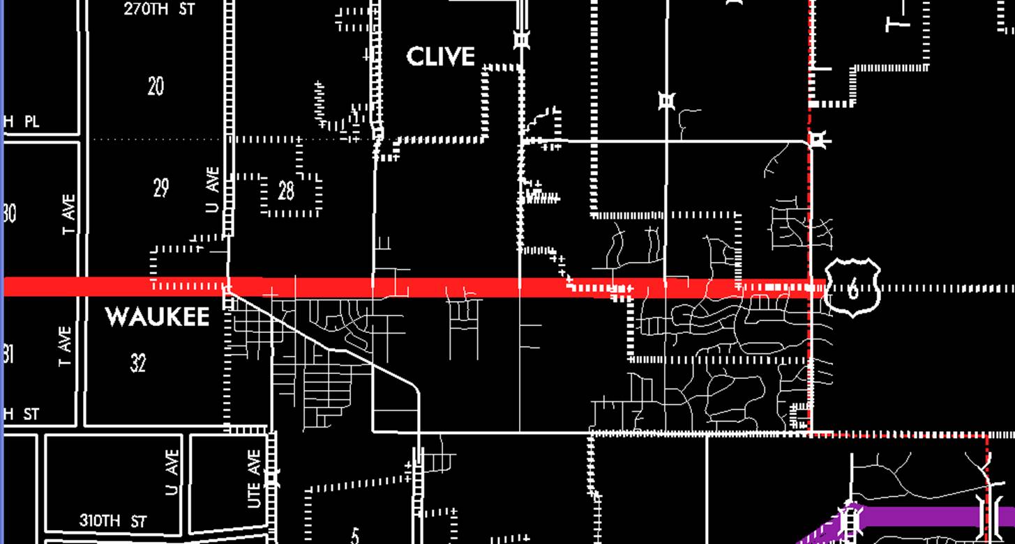
Waukee:
Beginning at the west corporation line (approximately 1,025 feet
west of the NW Corner of Section 35-T79N-R35W); thence easterly connecting with
Hickman Avenue to
the east corporation line/west corporation line of Clive connecting with
Hickman Road (approximately 2410 feet east of NW Corner Section 35-T79N-R26W).
Clive:
Beginning
on Hickman Road at the west corporation line of Clive; thence east on Hickman
Road to the east corporation line/southwest corporation line of
Urbandale/Dallas-Polk County line (approximately NE Corner Section
36-T79N-R26W, Dallas County) (NW Corner Section 31‑T79N‑R25W, Polk
County).
OFFICIAL
DESCRIPTION CHANGE
OFFICE:
Research and Analytics
EFFECTIVE
DATE: 08-23-2019
COUNTY:
Dallas
ROUTE:
US 6
ENTERED
BY: Paul Mauer
ENTERED
DATE: 08-14-2020

DISCUSSION/BACKGROUND:
Due to annexations by the Cities of Adel and Waukee
effective April 4, 2018 ,August 16, 2017 and August 23, 2019. It is recommended
that the primary route description for US 6 be revised.
New
Description ‑ US 6 and its extensions in Dallas County described as
follows:
Beginning on the Dallas‑Madison County line at a point
approximately 1704 feet west of the SE Corner of Section 32‑T78N‑R29W,
Dallas County (NE Corner of Section 5‑T77N‑R29W, Madison County);
thence northeasterly through Sections 32 and 33‑T73N‑R29W to a
point approximately 2612 feet east and 127 feet south of the N ¼ Corner of
Section 33‑T73N‑R29W; thence easterly following substantially the
section line of Sections 33, 34, 35, and 36‑T78N‑R29W and Sections
31 and 32‑T78N‑R28W to a point approximately 1094 feet west of the
NE Corner of said Section 32; thence northeasterly through Sections 29, 28, 27,
26, 23, and 24‑T78N‑R28W to the west corporation line of De Soto
connecting with an unnamed street (approximately 1869 feet east and 159 feet
north of the Center of said Section 24).
De Soto:
Beginning west corporation line; thence easterly connecting with
Guthrie Street at the junction of US 169; thence northerly on Guthrie Street to
the north corporation line.
Beginning again on the north corporation line of De Soto connecting
with Guthrie Street; thence north following substantially the section line of
Sections 19, 18, 7, and 6‑T78N‑R27W to the south corporation line
of Adel connecting with Nile Kinnick Drive South.
Adel:
Beginning at the south corporation line connecting with Nile
Kinnick Drive South; thence northerly on Nile Kinnick Drive South to the north
corporation line at the intersection of 302nd Place.
Beginning again at the north corporation line of Adel connecting
with Nile Kinnick Drive South; thence northerly to the north corporation line
of Adel connecting with Nile Kinnick Drive South (approximately 70 feet west of
the NW Corner of Section 6-T78N-R27W).
Adel:
Beginning at the south corporation line connecting with Nile
Kinnick Drive South; thence northerly, northwesterly and northerly on Nile
Kinnick Drive South connecting with Greene Street at the Junction of US 169;
thence easterly on Greene Street to the east corporation line at the
intersection of R Avenue (approximately 1.330 feet west of the NW Corner of
Section 35-T79N-R35W).
Beginning again at the east corporation line of Adel at the
intersection of R Avenue (approximately 1.330 feet west of the NW Corner of
Section 35-T79N-R35W); thence easterly to the west corporation line of Waukee
(approximately 1,025 feet west of the NW Corner of Section 35-T79N-R35W).
Waukee:
Beginning at the west corporation line (approximately 1,025 feet
west of the NW Corner of Section 35-T79N-R35W); thence easterly connecting with
Hickman Avenue to
the east corporation line/west corporation line of Clive connecting with
Hickman Road (approximately 2410 feet east of NW Corner Section 35-T79N-R26W).
Clive:
Beginning
on Hickman Road at the west corporation line of Clive; thence east on Hickman
Road to the east corporation line/southwest corporation line of
Urbandale/Dallas-Polk County line (approximately NE Corner Section
36-T79N-R26W, Dallas County) (NW Corner Section 31‑T79N‑R25W, Polk
County).
OFFICIAL
DESCRIPTION CHANGE
OFFICE:
Research and Analytics
EFFECTIVE
DATE: 4-23-2018
COUNTY:
Dallas
ROUTE:
US 6
ENTERED
BY: Paul Mauer
ENTERED
DATE: 10-29-2019
DISCUSSION/BACKGROUND:
Due to annexations by the Cities of Adel and Waukee
effective April 4, 2018 and August 16, 2017. It is recommended that the primary
route description for US 6 be revised.
New
Description ‑ US 6 and its extensions in Dallas County described as
follows:
Beginning on the Dallas‑Madison County line at a point
approximately 1704 feet west of the SE Corner of Section 32‑T78N‑R29W,
Dallas County (NE Corner of Section 5‑T77N‑R29W, Madison County);
thence northeasterly through Sections 32 and 33‑T73N‑R29W to a
point approximately 2612 feet east and 127 feet south of the N ¼ Corner of
Section 33‑T73N‑R29W; thence easterly following substantially the
section line of Sections 33, 34, 35, and 36‑T78N‑R29W and Sections
31 and 32‑T78N‑R28W to a point approximately 1094 feet west of the
NE Corner of said Section 32; thence northeasterly through Sections 29, 28, 27,
26, 23, and 24‑T78N‑R28W to the west corporation line of De Soto
connecting with an unnamed street (approximately 1869 feet east and 159 feet
north of the Center of said Section 24).
De Soto:
Beginning west corporation line; thence easterly connecting with
Guthrie Street at the junction of US 169; thence northerly on Guthrie Street to
the north corporation line.
Beginning again on the north corporation line of De Soto connecting
with Guthrie Street; thence north following substantially the section line of
Sections 19, 18, 7, and 6‑T78N‑R27W to the south corporation line
of Adel connecting with Nile Kinnick Drive South.
Adel:
Beginning at the south corporation line connecting with Nile
Kinnick Drive South; thence northerly on Nile Kinnick Drive South to the north
corporation line at the intersection of 302nd Place.
Beginning again at the north corporation line of Adel connecting
with Nile Kinnick Drive South; thence northerly to the north corporation line
of Adel connecting with Nile Kinnick Drive South (approximately 70 feet west of
the NW Corner of Section 6-T78N-R27W).
Adel:
Beginning at the south corporation line connecting with Nile
Kinnick Drive South; thence northerly, northwesterly and northerly on Nile
Kinnick Drive South connecting with Greene Street at the Junction of US 169;
thence easterly on Greene Street to the east corporation line at the
intersection of R Avenue (approximately 1.330 feet west of the NW Corner of Section
35-T79N-R35W).
Beginning again at the east corporation line of Adel at the
intersection of R Avenue (approximately 1.330 feet west of the NW Corner of Section
35-T79N-R35W); thence easterly to the west corporation line of Waukee
(approximately 1,025 feet west of the NW Corner of Section 35-T79N-R35W).
Waukee:
Beginning at the west corporation line (approximately 1,025 feet
west of the NW Corner of Section 35-T79N-R35W); thence easterly connecting with
Hickman Avenue to
the east corporation line/west corporation line of Clive connecting with
Hickman Road (approximately 2410 feet east of NW Corner Section 35-T79N-R26W).
Clive:
Beginning
on Hickman Road at the west corporation line of Clive; thence east on Hickman
Road to the east corporation line/southwest corporation line of
Urbandale/Dallas-Polk County line (approximately NE Corner Section
36-T79N-R26W, Dallas County) (NW Corner Section 31‑T79N‑R25W, Polk
County).
OFFICIAL
DESCRIPTION CHANGE
OFFICE: Transportation Data
EFFECTIVE DATE: 07-01-2003
ENTERED
BY: Stefani Wonders
ENTERED
DATE: 08-23-2006
DISCUSSION/BACKGROUND:
Senate File 451 transferred US 6 in Dallas County
from the
Dallas‑Madison County line at a point approximately 1,285 feet west of
the SE Corner of Section 32‑T78N‑R29W, Dallas County (NE Corner of
Section 5‑T77N‑R29W, Madison County); thence northeast through
Sections 32 and 33‑T78N‑R29W to a point approximately 233 feet east
and 1,000 feet south of the N ¼ Corner of Section 33-T78N‑R29W (junction
Interstate 80); thence northerly through Sections 33, 28, and 21‑T78N‑R29W
to a point approximately 400 feet south of the center of Section 21‑T78N‑R29W;
thence in a northeasterly direction to a point approximately 600 feet south and
¼ mile west of the NE Corner of said Section 21; thence north, northwesterly,
and northerly through Sections 21, 16, 9, and 4‑T78N‑R29W to the
south corporation line of Redfield, connecting with an unnamed street; thence
in a northeasterly direction on unnamed street to the east corporation line;
thence northeasterly and easterly through Sections 4, 3, 2, and 1‑T78N‑R29W;
thence easterly and northeasterly through the north part of Sections 6, 5, and
4‑T78N‑R26W and the south part of Sections 35 and 36‑T79N‑R28W
and Section 31-T79N‑R27W to the west corporation line of Adel connecting
with Greene Street; thence northeast and east on Greene Street to the junction
of US 169, to city and county
jurisdiction on July 1, 2003.
PROPOSAL/ACTION
RECOMMENDATION:
It
is recommended to approve deleting the present description of US 6 in Dallas County from the
primary road system and approve including the attached new description of US 6
in the primary road system.
Locate
US 6 and its extensions in Dallas
County as follows:
Adel:
Beginning
at the junction of US 169 on Greene Street; thence east on Greene Street to the
east corporation line.
Beginning
again on the east corporation line of Adel connecting with Greene Street
(approximately 1345 feet west of the NW Corner Section 33-T79N-R27W); thence
east, southeast, and northeast direction through Sections 32, 33, and 34‑T79N‑R27W
to a point approximately 1,500 feet west of the NE Corner said Section 34;
thence east following substantially the section line of Sections 34, 35 and 36‑T79N‑R27W;
and Sections 31 and 32‑T79N‑R26W to the west corporation limits of
Waukee connecting with Hickman Avenue (approximately N ¼ Corner of said Section
32..
Waukee:
Beginning
on Hickman Avenue at the west corporation line; thence east on Hickman Avenue
to the east corporation line/west corporation line of Clive (approximately 2410
feet east of NW Corner Section 35-T79N-R26W).
Clive:
Beginning
on Hickman Avenue at the west corporation line of Clive; thence east on Hickman
Avenue to the east corporation line/southwest corporation line of
Urbandale/Dallas-Polk County line (approximately NE Corner Section
36-T79N-R26W, Dallas County) (NW Corner Section 31‑T79N‑R25W, Polk
County).
OFFICIAL DESCRIPTION CHANGE
COUNTY: Dallas
ROUTE: US 6
STAFF
ACTION NUMBER: S-87-708
APPROVAL
DATE: 12-18-86
New
Description ‑ US 6 and its extensions in Dallas County
described as follows:
Beginning
on the Dallas‑Madison County line at a point approximately 1,285 feet
west of the SE Corner of Section 32‑T78N‑R29W, Dallas County (NE
Corner of Section 5‑T77N‑R29W, Madison County); thence northeast
through Sections 32 and 33‑T78N‑R29W to a point approximately 233
feet east and 1,000 feet south of the N ¼ Corner of Section 33-T78N‑R29W
(junction Interstate 80); thence northerly through Sections 33, 28, and 21‑T78N‑R29W
to a point approximately 400 feet south of the center of Section 21‑T78N‑R29W;
thence in a northeasterly direction to a point approximately 600 feet south and
¼ mile west of the NE Corner of said Section 21; thence north, northwesterly,
and northerly through Sections 21, 16, 9, and 4‑T78N‑R29W to the
south corporation line of Redfield, connecting with an unnamed street.
Redfield:
Beginning
on an unnamed street at the south corporation line; thence in a northeasterly
direction on unnamed street to the east corporation line.
Beginning
again on the east corporation line of Redfield connecting with an unnamed
street; thence northeasterly and easterly through Sections 4, 3, 2, and 1‑T78N‑R29W;
thence easterly and northeasterly through the north part of Sections 6, 5, and
4‑T78N‑R26W and the south part of Sections 35 and 36‑T79N‑R28W
and Section 31-T79N‑R27W to the west corporation line of Adel connecting
with Greene Street.
Adel:
Beginning
on Greene Street at the west corporation line; thence northeast and east on
Greene Street to the east corporation line.
Beginning
again on the east corporation line of Adel connecting with Greene Street;
thence east, southeast, and northeast direction through Sections 32, 33, and 34‑T79N‑R27W
to a point approximately 1,500 feet west of the NE Corner said Section 34;
thence east following substantially the section line of Sections 34, 35 and 36‑T79N‑R27W;
and Sections 31 and 32‑T79N‑R26W to the west corporation limits of
Waukee connecting with an unnamed street.
Waukee:
Beginning
on an unnamed street at the west corporation line; thence east on unnamed
street to the east corporation line.
Beginning
again at the east corporation line of Waukee connecting with an unnamed
street; thence east following substantially the section line of Sections 35 and
36‑T79N‑R26W to the Dallas‑Polk County line at a point near
the NE Corner Section 36‑T79N‑R26W, Dallas County (NW Corner
Section 31‑T79N‑R25W, Polk County).
STAFF
ACTION
OFFICE: Transportation Inventory
STAFF
ACTION NUMBER: S-83-520
SUBMITTED
BY: Patrick R. Cain
SUBMITTAL
DATE: 12-15-82
DISCUSSION/BACKGROUND:
US
6 begins at the Dallas‑Madison County line approximately one mile
southeast of the City of Dexter and proceeds northeasterly via the cities of
Redfield, Adel, and Waukee to the Dallas‑Polk County line approximately
two miles west of the City of Clive.
Due
to an annexation to the north part of the City of Waukee, the present description
of US 6 in Dallas County should be deleted and the new description added should
be officially included in the primary road system to reflect this change in
corporate limits. US 6 in Dallas County
and in the Cities of Redfield and Adel remains unchanged.
PROPOSAL/ACTION
RECOMMENDATION:
It
is recommended to approve deleting the present description of US 6 in Dallas County from the primary
road system and approve including the attached new description of US 6 in the
primary road system.
Locate
US 6 and its extensions in Dallas
County as follows:
Beginning
on the Dallas‑Madison County line at a point approximately 1,285 feet
west of the SE Corner of Section 32‑T78N‑R29W, Dallas County (NE
Corner of Section 5‑T77N‑R29W, Madison County); thence
northeasterly through Sections 32 and 33‑T78N‑R29W to a point
approximately 233 feet east and 1,000 feet south of the N ¼ Corner of Section
33‑T78N‑R29W (junction Interstate 80); thence northerly through
Sections 33, 28, and 21-T78N-R29W to a point approximately 400 feet south of
the center of Section 21-T78N‑R29W; thence in a northeasterly direction
to a point approximately 800 feet south and ¼ mile west of the NE Corner of
said Section 21; thence north, northwesterly, and northerly through Sections
21, 16, 9, and 4-T78N-R29W to the south corporation line of the City of
Redfield, connecting with an unnamed street.
Redfield:
Beginning
at the south corporation line connecting with an unnamed street; thence in a
northeasterly direction to the east corporation line connecting with an unnamed
street.
Beginning
again on the east corporation line of the City of Redfield connecting with an
unnamed street; thence northeasterly and easterly through Sections 4, 3, 2, and
1‑T78N‑R29W; thence easterly and northeasterly through the north
part of Sections 6, 5, and 4‑T78N‑R28W and the south part of
Sections 35 and 36‑T79N‑R28W and Section 31‑T79N‑R27W
to the west corporation line of the City of Adel connecting with an unnamed
street.
Adel:
Beginning
at the west corporation line connecting with an unnamed street; thence
northeasterly and easterly to the east corporation line connecting with an
unnamed street.
Beginning
again on the east corporation line of the City of Adel connecting with an
unnamed street; thence in an easterly, south easterly, and northeasterly
direction through Sections 32, 33, and 34‑T79N‑R27W to a point
approximately 1,500 feet west of the NE Corner said Section 34; thence easterly
following substantially the section line of Sections 35 and 36‑T79N‑R27W;
and Sections 31 and 32‑T79N‑R26W to the west corporation limits of
the City of Waukee connecting with an unnamed street.
Waukee:
Beginning
at the west corporation line connecting with an unnamed street; thence easterly
to the east corporation line connecting with an unnamed street.
Beginning
again at the east corporation line of the City of Waukee connecting with an
unnamed street; thence east following substantially the section line of
Sections 35 and 36‑T79N‑R26W to the Dallas‑Polk County line
at a point near the NE Corner Section 36‑T79N‑R26W, Dallas County
(NW Corner Section 31‑T79N‑R25W, Polk County).
REVISED:
12-18-86
COMMISSION
ORDER
DIVISION: Planning & Research
COMMISSION
ORDER NUMBER: PR-81-675
SUBMITTED
BY: Patrick R. Cain
MEETING
DATE: 4-28-81
DISCUSSION/BACKGROUND:
To
maintain continuity in the US
route numbering system, US 6 in Dallas
County should be deleted from the primary road system and the new description
added should be officially included in the primary road system.
US
6 begins at the Dallas‑Madison County line approximately one mile
southeast of the City of Dexter and proceeds northeasterly via the cities of
Redfield, Adel, and Waukee to the Dallas‑Polk County line approximately
two miles west of the City of Clive.
PROPOSAL/ACTION
RECOMMENDATION:
It
is recommended the commission approve deleting the present description of US 6
in Dallas
County from the primary road system and approve including the attached new
description of US 6 in the primary road system.
Locate
US 6 and its extensions in Dallas
County as follows:
Beginning
on the Dallas‑Madison County line at a point approximately 1285 feet
west of the SE Corner of Section 32‑T78N‑R29W, Dallas County (NE
Corner of Section 5‑T77N‑R29W, Madison County); thence
northeasterly through Sections 32 and 33‑T78N‑R29W to a point
approximately 233 feet east and 1000 feet south of the N ¼ Corner of Section 33‑T78N‑R29W
(junction Interstate 80); thence northerly through Sections 33, 28, and 21‑T78N‑R29W
to a point approximately 400 feet south of the center of Section 21-T78N-R29W;
thence in a northeasterly direction to a point approximately 800 feet south
and ¼ mile west of the NE Corner of said Section 21; thence north,
northwesterly, and northerly through Sections 21, 16, 9, and 4‑T78N‑R29W
to the south corporation line of the City of Redfield, connecting with an
unnamed street.
Redfield:
Beginning
at the south corporation line connecting with an unnamed street; thence in a
northeasterly direction to the east corporation line connecting with an unnamed
street.
Beginning
again on the east corporation line of the City of Redfield connecting with an
unnamed street; thence northeasterly and easterly through Sections 4, 3, 2, and
1‑T78N‑R29W; thence easterly and northeasterly through the north
part of Sections 6, 5, and 4‑T78N‑R28W and the south part of
Sections 35 and 36-T78N-R28W and Section 31‑T79N‑R27W to the west
corporation line of the City of Adel connecting with an unnamed street.
Adel:
Beginning
at the west corporation line connecting with an unnamed street; thence
northeasterly and easterly to the east corporation line connecting with an
unnamed street.
Beginning
again on the east corporation line of the City of Adel connecting with an
unnamed street; thence in an easterly, southeasterly, and northeasterly
direction along the south side of the Chicago, Milwaukee, St. Paul &
Pacific Railroad and substantially parallel thereto through Sections 32, 33,
and 34‑T79N‑R27W to a point approximately 1500 feet west of the NE
Corner said Section 34; thence easterly following substantially the section
line of Sections 35 and 36‑T79N‑R27W; and Sections 31 and 32‑T79N‑R26W
to the west corporation limits of the City of Waukee connecting with an unnamed
street.
Waukee:
Beginning
at the west corporation line connecting with an unnamed street; thence easterly
to the east corporation line connecting with an unnamed street.
Beginning
again at the east corporation line of the City of Waukee connecting with an
unnamed street; thence east following substantially the section line of
Sections 34, 35, and 36‑T79N‑R26W to the Dallas‑Polk County
line at a point near the NE Corner Section 36‑T79N‑R26W, Dallas
County (NW Corner Section 31‑T79N‑R25W, Polk County).
REVISED:
12-13-82
COMMISSION
ORDER
DIVISION: Planning & Research
COMMISSION
ORDER NUMBER: PR-79-272
SUBMITTED
BY: C.I. MacGillivray
MEETING
DATE: 11-2-78
DISCUSSION/BACKGROUND:
Due
to the review of our Primary Road System records, US 6 in Dallas County should be deleted from the
Primary System and the new description added should be officially included
into the Primary Road System.
US
6 begins at the Dallas‑Guthrie County line in Dexter, Iowa and travels
easterly, northerly, and easterly via Dexter, Redfield, Adel, and Waukee, Iowa
to the Dallas‑Polk County line approximately 2 miles east of Waukee,
Iowa.
PROPOSAL/ACTION
RECOMMENDATION:
Locate
US 6 and its extensions in Dallas
County as follows:
Dexter:
Beginning
at the west corporation line connecting with an unnamed street; thence easterly
to the east corporation line connecting with an unnamed street.
Beginning
on the east corporation line of the City of Dexter connecting with unnamed
street; thence east following substantially the section line of Sections 32 and
33‑T78N‑R29W to a point near the N ¼ Corner of said Section 33
(Interstate 80 Interchange); thence north through Sections 28 and 21-T78N-R29W
to a point approximately 400 feet south of the center of Section 21-T78N-R29W;
thence in a northeasterly direction to a point approximately 800 feet south and
¼ mile west of the NE Corner of said Section 21; thence north, northwesterly,
and northerly through Sections 21, 16, 9, and 4‑T78N‑R29W to the
south corporation line of the City of Redfield, connecting with an unnamed
street.
Redfield:
Beginning
at the south corporation line connecting with an unnamed street; thence in a
northeasterly direction to the east corporation line connecting with an unnamed
street.
Beginning
again on the east corporation line of the City of Redfield connecting with an
unnamed street; thence northeasterly and easterly through Sections 4, 3, 2, and
1‑T78N‑R29W; thence easterly and northeasterly through the north
part of Sections 6, 5, and 4‑T78N‑R28W and the south part of
Sections 35 and 36‑T79N‑R28W and Section 31‑T79N‑R27W
to the west corporation line of the City of Adel connecting with an unnamed
street.
Adel:
Beginning
at the west corporation line connecting with an unnamed street; thence
northeasterly and easterly to the east corporation line connecting with an
unnamed street.
Beginning
again on the east corporation line of the City of Adel connecting with an
unnamed street; thence in an easterly, southeasterly, and northeasterly
direction along the south side of the Chicago, Milwaukee, St. Paul &
Pacific Railroad and substantially parallel thereto through Sections 32, 33,
and 34‑T79N‑R27W to a point approximately 1500 feet west of the NE
Corner said Section 34; thence easterly following substantially the section
line of Sections 35 and 36‑T79N‑R27W; and Sections 31 and 32‑T79N‑R26W
to the west corporation limits of Waukee connecting with an unnamed street.
Waukee:
Beginning
at the west corporation line connecting with an unnamed street; thence easterly
to the east corporation line connecting with an unnamed street.
Beginning
again at the east corporation line of the City of Waukee connecting with an
unnamed street; thence east following substantially the section line of
Sections 34, 35, and 36‑T79N‑R26W to the Dallas‑Polk County
line at a point near the NE Corner Section 36‑T79N‑R26W, Dallas
County (NW Corner Section 31‑T79N‑R25W, Polk County).
NOW,
THEREFORE: Be it resolved that the Iowa Department of Transportation approve
the location of US 6 in Dallas County, Iowa.
NOTE:
To become effective upon adoption of this resolution.
REVISED:
4-28-81
COMMISSION
ORDER
DIVISION: Planning & Research
SUBMITTED
BY: Raymond L. Kassel
MEETING
DATE: 9-21-76
DISCUSSION/BACKGROUND:
Due
to the review of our Primary Road System records, US 6 in Dallas County should be deleted from the
Primary System and the new description added should be officially included
into the Primary Road System.
US
6 begins at the Dallas‑Guthrie County line in Dexter, Iowa and travels
easterly, northerly, and easterly via Dexter, Redfield, Adel, and Waukee, Iowa
to the Dallas‑Polk County line approximately 2 miles east of Waukee,
Iowa.
PROPOSAL/ACTION
RECOMMENDATION:
Locate
US 6 and its extensions in Dallas
County as follows:
Dexter:
Beginning
at the west corporation line connecting with an unnamed street; thence easterly
to the east corporation line connecting with an unnamed street.
Beginning
on the east corporation line of the City of Dexter connecting with unnamed
street; thence east following substantially the section line of Sections 32 and
33‑T78N‑R29W to a point near the N ¼ Corner of said Section 33
(Interstate 80 Interchange); thence north through Sections 28 and 21-T78N‑R29W
to a point approximately 400 feet south of the center of Section 21-T78N‑R29W;
thence in a northeasterly direction to a point approximately 800 feet south and
¼ mile west of the NE Corner of said Section 21; thence north, northwesterly,
and northerly through Sections 21, 16, 9, and 4‑T78N‑R29W to the
south corporation line of the City of Redfield, connecting with an unnamed
street.
Redfield:
Beginning
at the south corporation line connecting with an unnamed street; thence in a
northeasterly direction to the east corporation line connecting with an unnamed
street.
Beginning
again on the east corporation line of the City of Redfield connecting with an
unnamed street; thence northeasterly and easterly through Sections 4, 3, 2, and
1‑T78N‑R29W; thence easterly and northeasterly through the north
part of Sections 6, 5, and 4‑T78N‑R28W and the south part of
Sections 35 and 36‑T79N‑R28W and Section 31‑T79N‑R27W
to the west corporation line of the City of Adel connecting with an unnamed
street.
Adel:
Beginning
at the west corporation line connecting with an unnamed street; thence
northeasterly and easterly to the east corporation line connecting with an
unnamed street.
Beginning
again on the east corporation line of the City of Adel connecting with an
unnamed street; thence in an easterly, southeasterly, and northeasterly
direction along the south side of the Chicago, Milwaukee, St. Paul &
Pacific Railroad and substantially parallel thereto through Sections 32, 33,
and 34‑T79N‑R27W to a point approximately 1500 feet west of the NE
Corner said Section 34; thence easterly following substantially the section
line of Sections 35 and 36‑T79N‑R27W; and Sections 31 and 32‑T79N‑R26W
to the west corporation limits of Waukee connecting with an unnamed street.
Waukee:
Beginning
at the west corporation line connecting with an unnamed street; thence easterly
to the east corporation line connecting with an unnamed street.
Beginning
again at the east corporation line of the City of Waukee connecting with an
unnamed street; thence east following substantially the section line of
Sections 34, 35, and 36‑T79N‑R26W to the Dallas‑Polk County
line at a point near the NE Corner Section 36‑T79N‑R26W, Dallas
County (NW Corner Section 31‑T79N‑R25W, Polk County).
NOW,
THEREFORE: Be it resolved that the Iowa Department of Transportation approve
the location of US 6 in Dallas County, Iowa.
NOTE:
To become effective upon adoption of this resolution.
OFFICIAL
DESCRIPTION CHANGE
COUNTY: Dallas
ROUTE: US 6
APPROVAL
DATE: 12-13-66
Dexter:
Commencing
on State Street at the west corporation line; thence easterly on State Street
to the east corporation line.
Beginning
on the east corporation line of the Town of Dexter connecting with State
Street; thence east following substantially the section line to a point near
the S ¼ Corner Section 28T78N‑R29W; thence north to a point
approximately 400 feet south of the Center Section 21‑T78N‑R29W;
thence in a northeasterly direction to a point approximately 800 feet south and
¼ mile west of the NE Corner Section 21‑T78N‑R29W; thence north to
a point approximately 1,000 feet north and ¼ mile west of the SE Corner Section
9‑T78N‑R29W; thence in a northwesterly and northerly direction
through Sections 9 and 4-T78N‑R29W to the south corporation line of the
Town of Redfield connecting with an unnamed street.
Redfield:
Commencing
on an unnamed street at the south corporation line; thence in a northeasterly
direction on said unnamed street to the east corporation line.
Beginning
again on the east corporation line of the Town of Redfield connecting with an
unnamed street on the south side of the Chicago, Milwaukee, St. Paul &
Pacific Railroad; thence in a northeasterly direction along the south side of
said railroad and substantially parallel thereto to a point approximately ¼
mile south and ¼ mile west of the NE Corner Section 3‑T78N‑R29W;
thence east to a point approximately ¼ mile east and ¼ mile south of the NW
Corner Section 5‑T78N‑R28W; thence in a northeasterly direction
through Section 5 and 4‑T78N‑R28W to a point approximately 700 feet
east of the NW Corner Section 4-T78N‑R28W; thence east to a point
approximately 400 feet west of the NE Corner Section 4‑T78N‑R28W;
thence in a northeasterly direction through Section 35 and 36‑T79N‑R28W
and Section 31-T79N‑R27W to the west corporation line of the Town of
Adel connecting with Greene Street.
Adel:
Commencing
on Greene Street at the west corporation line; thence easterly on Greene Street
to the east corporation line.
Beginning
again on the east corporation line of the Town of Adel, connecting with Green
Street; thence in an easterly direction along the south side of the Chicago,
Milwaukee, St. Paul & Pacific Railroad and substantially parallel thereto
through Sections 32, 33 and 34‑T79N‑R27W to a point approximately
1,500 feet west of the NE Corner Section 34‑T79N‑R27W; thence east
following substantially the section line to the west corporation line of the
Town of Waukee connecting with an unnamed street.
Waukee:
Commencing
on an unnamed street at the west corporation line; thence easterly along said
unnamed street to the east corporation line.
Beginning
again at the east corporation line of the Town of Waukee connecting with an
unnamed street; thence east following substantially the section line to the
Dallas‑Polk County line at a point near the NE Corner Section 36‑T79N‑R26W,
Dallas County (NW Corner Section 31‑T79N‑R25W, Polk County).
COMMISSION
RESOLUTION
DIVISION: Planning & Research
SUBMITTED
BY: Gene Mills
Add
to the Primary Road System the road,
Beginning
on the east corporation line of the Town of Dexter connecting with State
Street; thence east following substantially the section line to a point near
the S ¼ Corner Section 28‑T78N‑R29W; thence north to a point
approximately 400 feet south of the center of Section 21T78N‑R29W;
thence in a northeasterly direction to a point approximately 800 feet south
& ¼ mile west of the NE Corner Section 21‑T78N‑R29W; thence
north to a point approximately 1000 feet north and ¼ mile west of the SE Corner
Section 10‑T78N‑R29W; thence in a northwesterly and northerly
direction through Sections 9 and 4‑T78N‑R29W to the south
corporation line of the Town of Redfield, connecting with an unnamed street at
a point approximately 300 feet west of the Center Section 4‑T78N‑R29W.
Beginning
again on the east corporation line of the Town of Redfield connecting with an
unnamed street on the south side of the Chicago, Milwaukee, St. Paul and
Pacific Railroad; thence in a northeasterly direction along the south side of
said railroad and substantially parallel thereto to a point approximately ¼
mile south and ¼ mile west of the NE Corner Section 3‑T78N‑R29W;
thence east to a point approximately ¼ mile east and ¼ mile south of the NW
Corner Section 5‑T78N‑R28W; thence in a northeasterly direction
through Sections 5 and 4‑T78N‑R28W to a point approximately 700
feet east of the NW Corner Section 4‑T78N‑R28W; thence east to a
point approximately 400 feet west of the NE Corner Section 4-T79N-R28W; thence
in a northeasterly direction through Sections 35 and 26-T79N‑R28W and
Section 31‑T79N‑R27W to the west corporation line of the Town of
Adel connecting with Greene Street.
Beginning
again on the east corporation line of the Town of Adel connecting with Greene
Street; thence in an easterly direction along the south side of the Chicago,
Milwaukee, St. Paul & Pacific Railroad and substantially parallel thereto
through Sections 32, 33 and 34‑T79N‑R27W to a point approximately
1500 feet west of the NE Corner Section 34‑T79N‑R27W; thence east
following substantially the section line to the west corporation line of the
Town of Waukee at the NW Corner Section 33‑T79N‑R26W connecting
with an unnamed street.
Beginning
again at the east corporation line of the Town of Waukee
at the NE Corner Section 33‑T79N‑R26W; thence east following
substantially the section line to the Dallas‑Polk County Line at a point
near the NE Corner Section 36‑T79N‑R26W, Dallas
County (NW Corner Section 31‑T79N‑R25W,
Polk County).
BE
IT FURTHER RESOLVED that the Description of Primary Road No. US 6 in Dallas County in the Commission's minutes of
September 7, 1960, is hereby rescinded and the attached description is adopted.
NOTE:
To became effective upon adoption of this resolution.
COMMISSION
RESOLUTION
DIVISION: Planning & Research
SUBMITTED
BY: Gene Mills
Locate
the Extension of US 6 on streets or roads as follows:
Commencing
on Greene Street at the west corporation line; thence easterly on Greene Street
to the east corporation line.
BE
IT FURTHER RESOLVED that the Description of the Extension of US 6 in the City
(Town) of Adel, Dallas
County, as described and
the description attached is adopted.
NOTE:
To become effective upon adoption of this resolution.
COMMISSION
RESOLUTION
DIVISION: Planning & Research
SUBMITTED
BY: Gene Mills
Locate
the Extension of US 6 on streets or roads as follows:
Commencing
on an unnamed street at the west corporation line; thence easterly along said
unnamed street to the east corporation line.
BE
IT FURTHER RESOLVED that the Description of the Extension of US 6 in the City
(Town) of Waukee, Dallas
County, as described and
the attached description is adopted.
NOTE:
To became effective upon adoption of this resolution.
COMMISSION
RESOLUTION
DIVISION: Planning & Research
SUBMITTED
BY: Gene Mills
Remove
from the Primary Road System the road,
Beginning
on the Dallas‑Madison County Line at a point approximately 1285 feet west
of the SE Corner Section 32‑T78N‑R29W, Dallas County (NE Corner
Section 5-T77N‑R29W, Madison County); thence northeasterly through
Sections 32 and 33‑T78N‑R29W to a point near the NE Corner Section
33‑T78N‑R29W; thence east following substantially the section line
to a point near the N ¼ Corner Section 35‑T78N‑R27W; thence in a
northeasterly direction to a point approximately 700 feet north of the S ¼
Corner Section 25‑T78N‑R27W; thence in an easterly direction along
the south side of the Chicago, Rock Island and Pacific Railway and substantially
parallel thereto through Section 25‑T78N‑R27W and Sections 30, 29,
28, 27, 26 and 25‑T78N‑R26W to the Dallas‑Polk County Line at
a point approximately 1400 feet south of the NE Corner Section 25‑T78N‑R26W,
Dallas County (NW Corner Section 30‑T78N‑R25W, Polk County).
BE
IT FURTHER RESOLVED that the Description of US 6 in Dallas County
in the Commission's minutes of September 7, 1960, is hereby rescinded.
NOTE:
To become effective upon adoption of this resolution.