OFFICIAL
DESCRIPTION CHANGE
OFFICE:
Analytics
EFFECTIVE
DATE: 8-12-2020
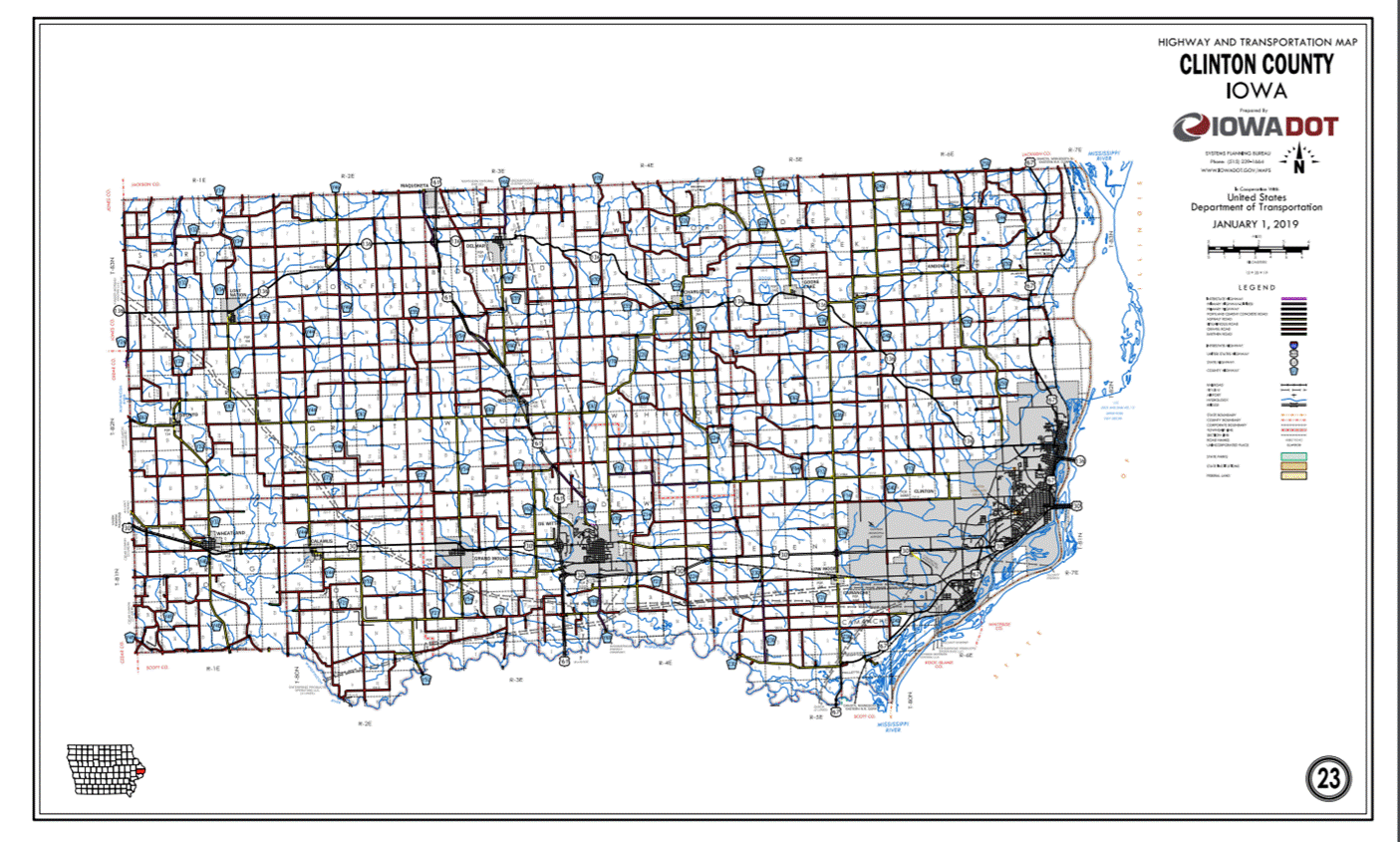
ROUTE:
US 30
COUNTY:
Clinton
ENTERED
BY: Paul
Mauer
ENTERED
DATE: 8-12-2020
New
Description - US 30 and its extensions in Clinton County described as follows:
Beginning
on the Cedar‑Clinton County Line at a point approximately 200 feet south
of the NW Corner Section 7‑T81N‑R1E, Clinton County (NE Corner
Section 12‑T81N‑R1W, Cedar County); thence in a southeasterly
direction along the south side of the Chicago and Northwestern Railway and
substantially parallel thereto through Sections 7, 8 and 9‑T81N‑R1E
to the west corporation line of the City of Wheatland.
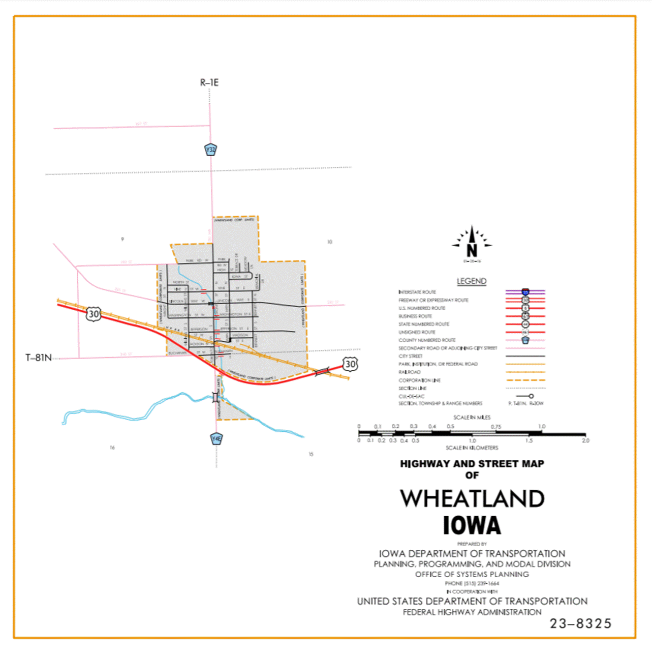
Wheatland:
Beginning
on the west corporation line connecting with an unnamed street; thence
southeasterly to the south corporation line connecting with an unnamed street.
Beginning
again on the south corporation line of the City of Wheatland, connecting with
an unnamed street; thence southeasterly to a point approximately 400 feet south
of the NE Corner Section 16‑T81N‑R1E; thence southeasterly and
northeasterly through the northern part of Section 15‑T81N‑R1E to a
point approximately 100 feet south of the NE Corner Section 15‑T81N‑R1E;
thence easterly following substantially the section line of Sections 14 and
13-T81N-R1E and Section 18‑T81N-R2E to the west corporation line of the
City of Calamus connecting with Clinton street.
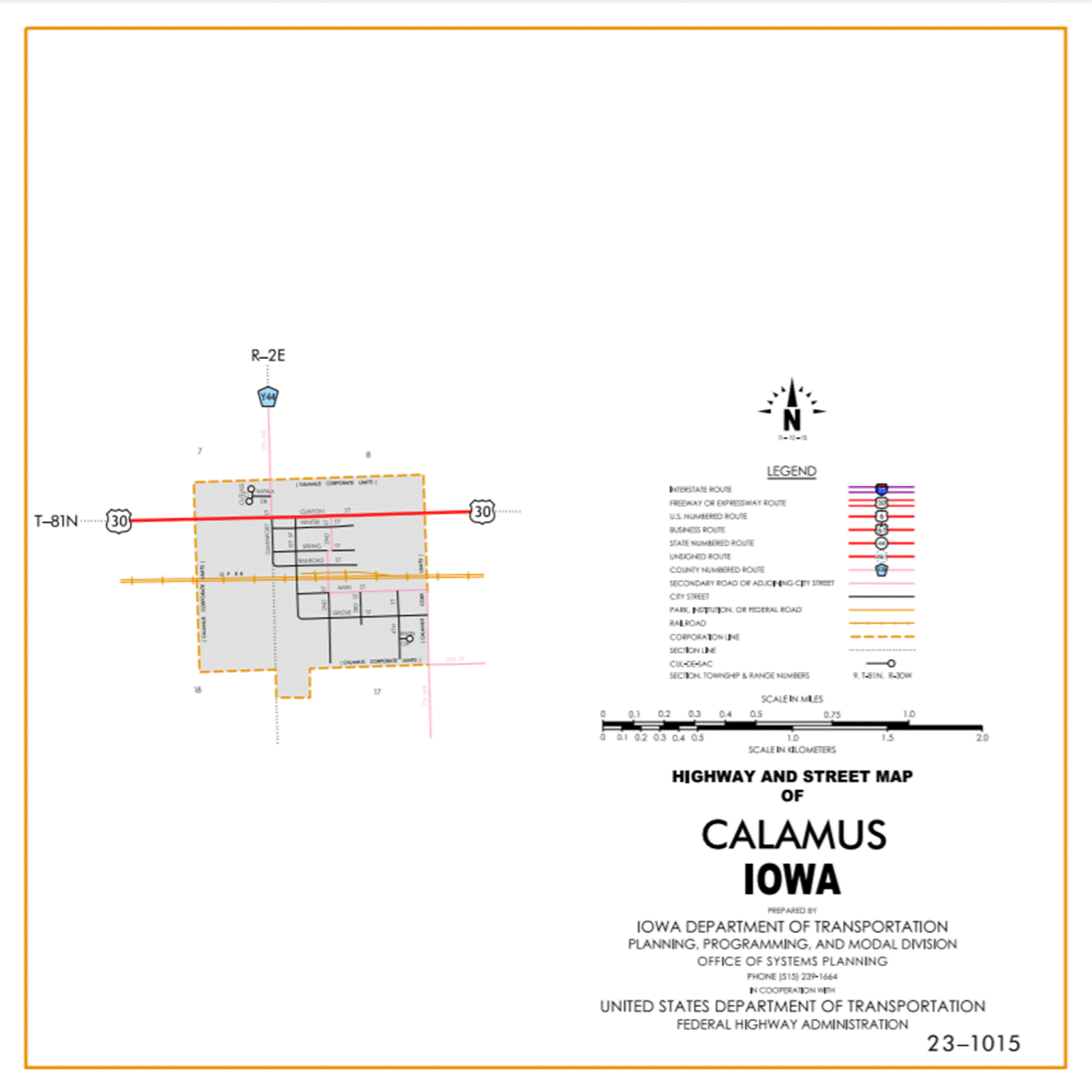
Calamus:
Beginning
at the west corporation line connecting at Clinton street; thence easterly to
the east corporation line connecting with Clinton street.
Beginning
again on the east corporation line of the City of Calamus, connecting with an Clinton
street; thence east following substantially the section line of Sections 17,
16, 15, 14 and 13‑T81N‑R2E and Section 18‑T81N‑R3E to a
point approximately 700 feet west of the NE Corner Section 18-T81N-R3E; thence
in a southeasterly direction through said Section 18 to the north corporation
line of the City of Grand Mound connecting with an unnamed street.
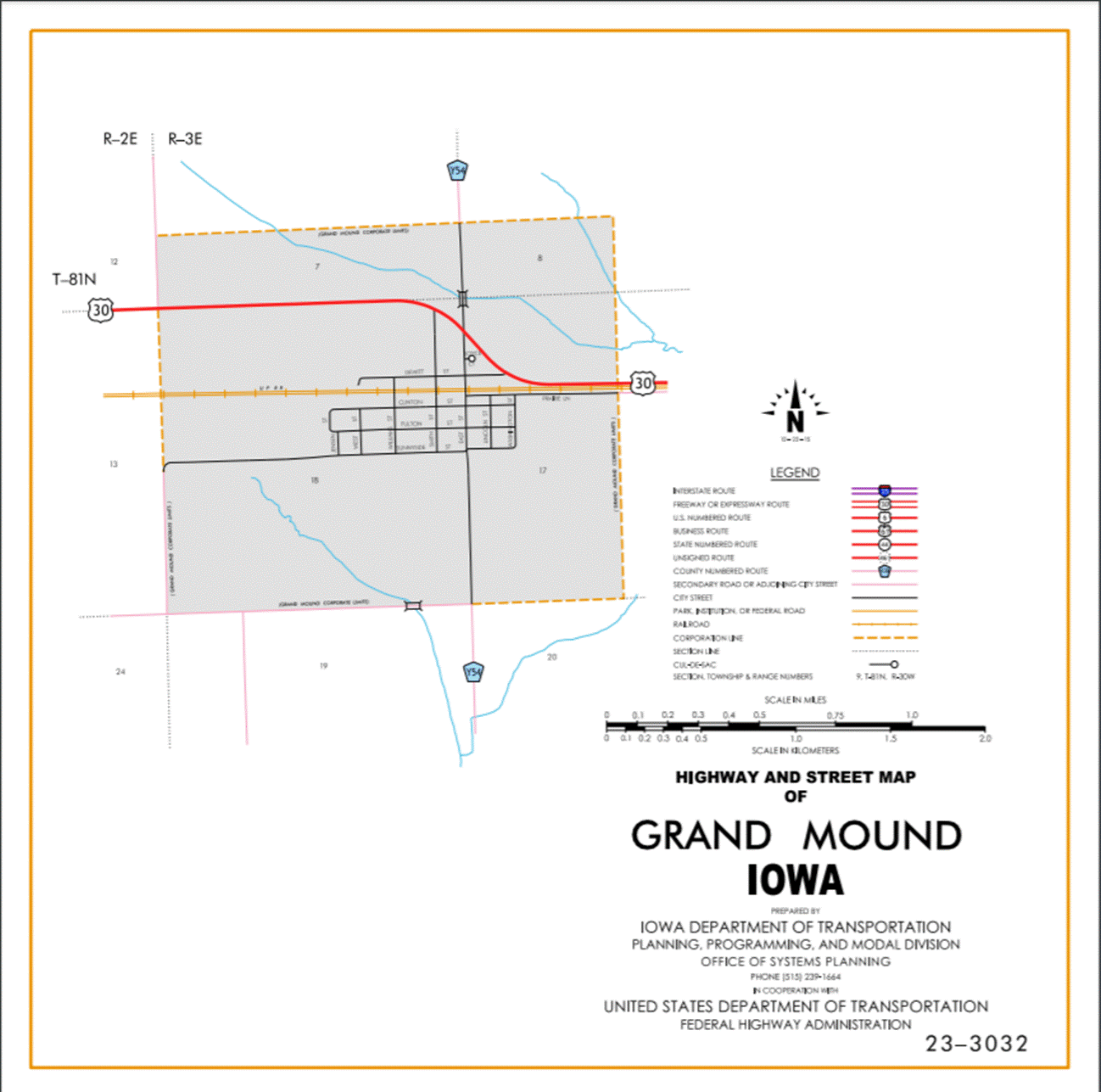
Grand
Mound:
Beginning
on the north corporation line connecting with an unnamed street; thence
southeasterly to the east corporation line connecting with an unnamed street.
Beginning
again on the east corporation line of the City of Grand Mound connecting with
an unnamed street; thence easterly through Sections 17, 16, 15 and 14-T81N‑R3E
to the west corporation line of the City of DeWitt connecting with an unnamed
street.
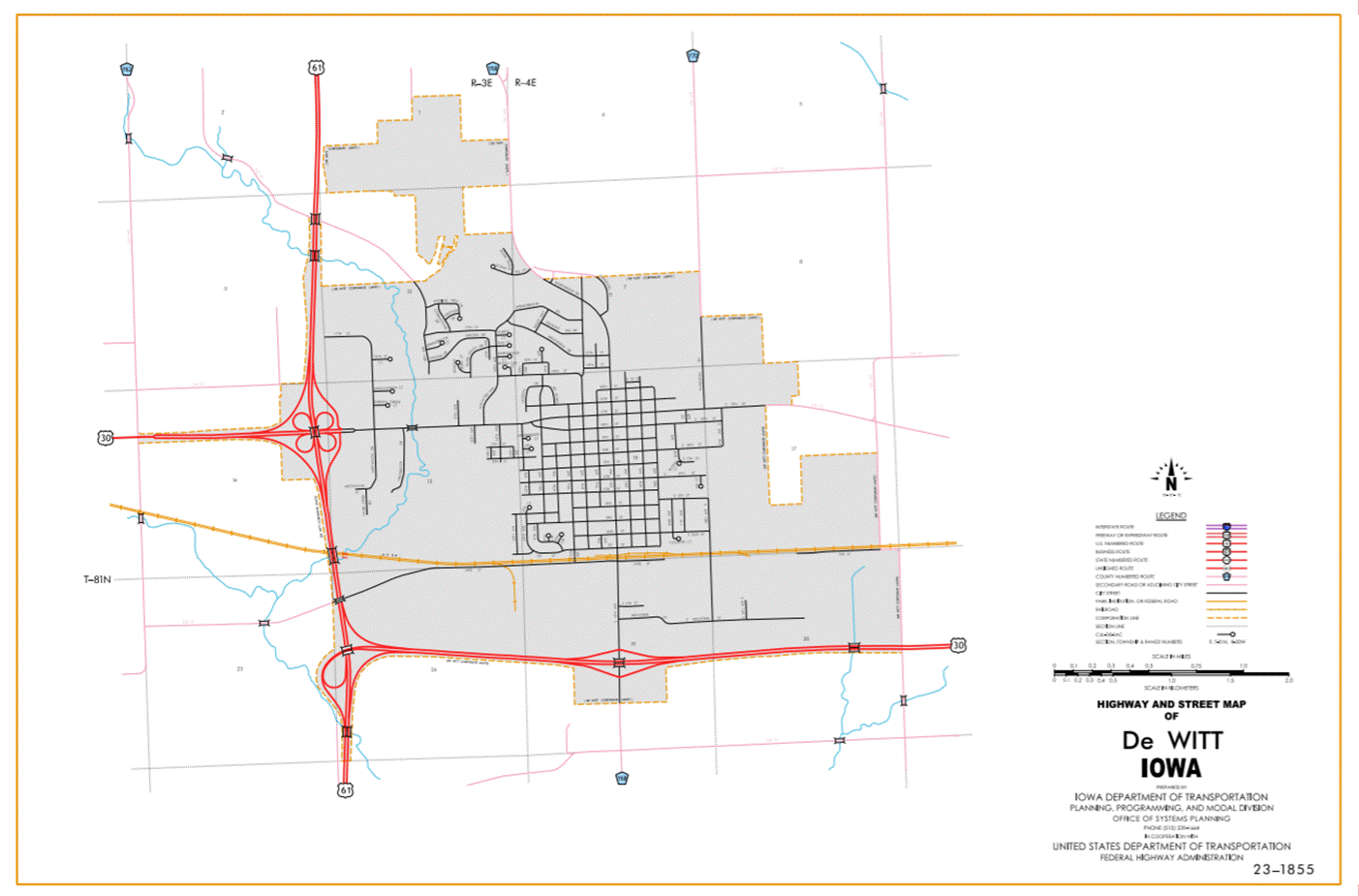
DeWitt:
Beginning
on the west corporation line connecting with an unnamed street; thence easterly
and southerly to the south corporation line connecting with an unnamed street;
thence southerly through Sections 14, 13 and 24‑T81N‑R3E to a point
approximately 2000 feet south and 400 feet east of the NW Corner Section 24‑T81N‑R3E;
thence easterly through Section 24‑T81N‑R3E and Sections 19 and 20‑T81N‑R4E;
thence easterly to the east corporation line connecting with an unnamed street.
Beginning
again on the east corporation line of the City of DeWitt connecting with an
unnamed street; thence easterly and northeasterly through Sections 21, 22, 23
and 24‑T81N‑R4E to a point approximately 225 feet east and 35 feet
south of the NW Corner Section 24‑T81N‑R4E, 2 or more extensions in
Clinton and Sections 19, 20, 21, 22, and 23‑T81N‑R5E to the west
corporation line of the City of Clinton, connecting with Lincoln Way.
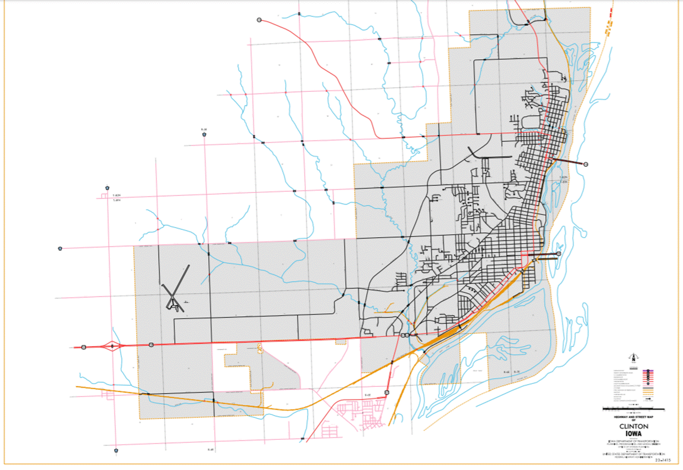
Clinton:
Beginning
on the west corporation line connecting with Lincoln Way; thence easterly on
Lincoln Way to the east corporation line.
Beginning
again on the east corporation line of the City of Clinton, connecting with
Lincoln Way; thence easterly through Section 19‑T81N‑R6E to the
west corporation line of the City of Clinton, connecting with Lincoln Way.
Clinton:
Beginning
on the west corporation line connecting with Lincoln Way; thence easterly on
Lincoln Way to the east corporation line.
Beginning
again on the east corporation line of the City of Clinton, connecting with
Lincoln Way; thence easterly through Section 21‑T81N‑R6E to the
west corporation line of the City of Clinton, connecting with Lincoln Way.
Clinton:
Beginning
again on the west corporation line connecting with Lincoln Way; thence easterly
on Lincoln Way to Camanche Avenue; thence northeasterly on Camanche Avenue to
11th Avenue South; thence easterly on 11th Avenue South to South 3rd Street;
thence northerly on South 3rd Street to 8th Avenue South; thence easterly on
8th Avenue South to the Iowa‑Illinois State Line.
Also
With
a spur beginning at the intersection of 8th Avenue South and South 3rd Street
(begin one‑way westbound); thence westerly on 8th Avenue South to South
4th Street; thence southerly on South 4th Street to 11th Avenue South (end one‑way
westbound).
STAFF
ACTION
OFFICE: Transportation Inventory
STAFF
ACTION NUMBER: S-85-616
SUBMITTED
BY:
Patrick R. Cain
SUBMITTAL
DATE: 12-5-84
DISCUSSION/BACKGROUND:
US
30 begins at the Clinton‑Cedar County Line approximately three miles
northwest of Wheatland, and travels easterly through Wheatland, Calamus, Grand
Mound, De Witt and Clinton to the Iowa‑Illinois State Line in the City of
Clinton.
The
official description for US 30 in Clinton County was found to be incorrect in
our official records. The existing
description should be replaced with the corrected version.
PROPOSAL/ACTION
RECOMMENDATION:
It
is recommended to approve revising the description of US 30 in Clinton County
and including the new description in the Primary Road System.
New
Description - US 30 and its extensions in Clinton County described as follows:
Beginning
on the Cedar‑Clinton County Line at a point approximately 200 feet south
of the NW Corner Section 7‑T81N‑R1E, Clinton County (NE Corner
Section 12‑T81N‑R1W, Cedar County); thence in a southeasterly
direction along the south side of the Chicago and Northwestern Railway and
substantially parallel thereto through Sections 7, 8 and 9‑T81N‑R1E
to the west corporation line of the City of Wheatland connecting with an
unnamed street.
Wheatland:
Beginning
on the west corporation line connecting with an unnamed street; thence
southeasterly to the south corporation line connecting with an unnamed street
east and 35 feet south of the NW Corner Section 24‑T81N‑R4E; thence
easterly following substantially the section line of Section 24‑T81N‑R4E
and Sections 19, 20, 21, 22 and 23‑T81N‑R5E to the west corporation
line of the City of Clinton, connecting with Lincoln Way.
Clinton:
Beginning
on the west corporation line connecting with Lincoln Way; thence easterly on
Lincoln Way to the east corporation line.
Beginning
again on the east corporation line of the City of Clinton, connecting with
Lincoln Way; thence easterly through Section 19‑T81N‑R6E to the
west corporation line of the City of Clinton, connecting with Lincoln Way.
Clinton:
Beginning
on the west corporation line connecting with Lincoln Way; thence easterly on
Lincoln Way to the east corporation line.
Beginning
again on the east corporation line of the City of Clinton, connecting with
Lincoln Way; thence easterly through Section 21‑T81N‑R6E to the
west corporation line of the City of Clinton, connecting with Lincoln Way.
Clinton:
Beginning
again on the west corporation line connecting with Lincoln Way; thence easterly
on Lincoln Way to Camanche Avenue; thence northeasterly on Camanche Avenue to
11th Avenue South; thence easterly on 11th Avenue South to South 3rd Street;
thence northerly on South 3rd Street to 8th Avenue South; thence easterly on
8th Avenue South to the Iowa‑Illinois State Line.
Also
With
a spur beginning at the intersection of 8th Avenue South and South 3rd Street
(begin one‑way westbound); thence westerly on 8th Avenue South to South
4th Street; thence southerly on South 4th Street to 11th Avenue South (end one‑way
westbound).
COMMISSION
ORDER
DIVISION: Planning & Research
COMMISSION
ORDER NUMBER:
PR-80-404
SUBMITTED
BY: Leland D. Smithson
MEETING
DATE:
1-23-80
DISCUSSION/BACKGROUND:
US
30 begins at the Clinton‑Cedar County line approximately three miles
northwest of Wheatland and travels easterly through Wheatland, Calamus, Grand
Mound, DeWitt and Clinton to the Iowa‑Illinois State line in the City of
Clinton.
Due
to an annexation to the west part of DeWitt in the north US 30, US 61 and
unsigned Iowa 948 interchange area; the present description of US 30 in Clinton
County should be revised. The new description added should be officially
included in the primary road system to reflect this change in corporate limits.
PROPOSAL/ACTION
RECOMMENDATION:
It
is recommended that the old description of US 30 in Clinton County be deleted
and the new description, as listed in the attached detailed description, be
included in the primary road system.
Locate
US 30 and its extensions in Clinton County as follows:
Beginning
on the Cedar-Clinton County line at a point approximately 200 feet south of the
NW Corner Section 7‑T81N‑R1E, Clinton County (NE Corner Section 12‑T81N‑R1W,
Cedar County); thence in a southeasterly direction along the south side of the
Chicago and North Western Railway and substantially parallel thereto through
Sections 7, 8 and 9‑T81N‑R1E to the west corporation line of the
City of Wheatland connecting with an unnamed street.
Wheatland:
Beginning
on the west corporation line connecting with an unnamed street; thence
southeasterly to the south corporation line connecting with an unnamed street.
Beginning
again on the south corporation line of the City of Wheatland, connecting with
an unnamed street; thence southeasterly to a point approximately 400 feet south
of the NE Corner Section 16‑T81N‑R1E; thence southeasterly and
northeasterly through the northern part of Section 15‑T81N‑R1E to a
point approximately 100 feet south of the NE Corner Section 15‑T81N‑R1E;
thence easterly following substantially the section line of Sections 14 and
13-T81N-R1E and Section 18‑T81N-R2E to the west corporation line of the
City of Calamus connecting with an unnamed street.
Calamus:
Beginning
at the west corporation line connecting at an unnamed street; thence easterly
to the east corporation line connecting with an unnamed street.
Beginning
again on the east corporation line of the City of Calamus, connecting with an
unnamed street; thence east following substantially the section line of
Sections 17, 16, 15, 14 and 13‑T81N‑R2E and Section 18‑T81N‑R3E
to a point approximately 700 feet west of the NE Corner Section 18-T81N-R3E;
thence in a southeasterly direction through said Section 18 to the north
corporation line of the City of Grand Mound connecting with an unnamed street.
Grand
Mound:
Beginning
on the north corporation line connecting with an unnamed street; thence
southeasterly to the east corporation line connecting with an unnamed street.
Beginning
again on the east corporation line of the City of Grand Mound connecting with
an unnamed street; thence easterly through Sections 17, 16, 15 and 14-T81N‑R3E
to the west corporation line of the City of DeWitt connecting with an unnamed
street.
DeWitt:
Beginning
on the west corporation line connecting with an unnamed street; thence easterly
and southerly to the south corporation line connecting with an unnamed street.
Beginning
again on the south corporation line of the City of DeWitt connecting with an
unnamed street; thence southerly through Sections 14, 13 and 24‑T81N‑R3E
to a point approximately 2000 feet south and 400 feet east of the NW Corner
Section 24‑T81N‑R3E; thence easterly through Section 24‑T81N‑R3E
and Section 19‑T81N‑R4E to the west corporation line of the City of
DeWitt connecting with an unnamed street.
DeWitt:
Beginning
on the west corporation line connecting with an unnamed street; thence easterly
to the east corporation line connecting with an unnamed street.
Beginning
again on the east corporation line of the City of DeWitt connecting with an
unnamed street; thence easterly and northeasterly through Sections 19, 20, 21,
22, 23 and 24‑T81N‑R4E to a point approximately 225 feet east and
35 feet south of the NW Corner Section 24‑T81N‑R4E, 2 or more
extensions in Clinton and Sections 19, 20, 21, 22, and 23‑T81N‑R5E
to the west corporation line of the City of Clinton, connecting with an unnamed
street.
Clinton:
Beginning
on the west corporation line connecting with an unnamed street; thence
easterly, northeasterly, and easterly to the Iowa-Illinois State line
connecting with an unnamed street.
Also
With
a spur beginning at the intersection of Eighth Avenue South and South Third
Street (begin one‑way westbound); thence westerly and southerly to the
intersection of South Fourth Street and 11th Avenue South (end one‑way
westbound).
REVISED:
12-5-84
COMMISSION
ORDER
DIVISION: Planning & Research
COMMISSION
ORDER NUMBER: PR-79-272
SUBMITTED
BY: C.I.
MacGillivray
MEETING
DATE: 11-2-87
DISCUSSION/BACKGROUND:
Due
to a review of our Primary Road System records, US 30 in Clinton County should be
deleted and the new description added should be officially included into the
Primary Road System.
US
30 begins at the Clinton‑Cedar County line approximately 3 miles
northwest of Wheatland, Iowa and travels easterly through Wheatland, Calamus,
Grand Mound, and Clinton to the Iowa‑Illinois State line in the City of
Clinton, Iowa.
PROPOSAL/ACTION
RECOMMENDATION:
Locate
US 30 and its extensions in Clinton County as follows:
Beginning on the Cedar‑Clinton
County line at a point approximately 200 feet south of the NW Corner Section 7‑T81N‑R1E,
Clinton County (NE Corner Section 12‑T81N‑R1W, Cedar County);
thence in a southeasterly direction along the south side of the Chicago and
Northwestern Railway and substantially parallel thereto through Sections 7, 8,
and 9‑T81N‑R1E to the west corporation line of the City of
Wheatland connecting with an unnamed street.
Wheatland:
Beginning
on the west corporation line connecting with an unnamed street; thence
southeasterly to the south corporation line connecting with an unnamed street.
Beginning
again on the south corporation line if the City of Wheatland, connecting with
an unnamed street; thence southeasterly to a point approximately 400 feet
south of the NE Corner Section 16‑T81N‑R1E; thence southeasterly
and northeasterly through the northern part of Section 15‑T81N‑R1E
to a point approximately 100 feet south of the NE Corner Section 15‑T81N‑R1E;
thence easterly following substantially the section line of Sections 14 and 13‑T81N‑R1E,
and Section 18‑T81N‑R2E to the west corporation line of the City of
Calamus connecting with an unnamed street.
Calamus:
Beginning
at the west corporation line connecting at an unnamed street; thence easterly
to the east corporation line connecting with an unnamed street.
Beginning
again on the east corporation line of the City of Calamus, connecting with an
unnamed street; thence east following substantially the section line of
Sections 17, 16, 15, 14, and 13‑T81N‑R2E and Section 18-T81N‑R3E
to a point approximately 700 feet west of the NE Corner Section 18-T81N‑R3E;
thence in a southeasterly direction to the north corporation line of the City
of Grand Mound connecting with an unnamed street.
Grand
Mound:
Beginning
on the north corporation line connecting with an unnamed street; thence
southeasterly to the east corporation line connecting with an unnamed street.
Beginning
again on the east corporation line of the City of Grand Mound connecting with an
unnamed street; thence easterly through Sections 17, 16, and 15 to a point
approximately 1300 feet south and 450 feet west of the NE Corner Section 14‑T81N‑R3E;
(west junction US 61); thence southeasterly through Sections 14, 13, and 24 to
a point approximately 2000 feet south and 400 feet east of the NW Corner
Section 24‑T81N‑R3E; thence easterly through Section 24‑T81N‑R3E;
thence easterly and northeasterly through Sections 19 (east junction US 61),
20, 21, 22, 23, and 24 to a point approximately 225 feet east and 35 feet south
of the NW Corner Section 24‑T81N‑R4E; thence easterly following
substantially the section line of Section 24‑T81N‑R4E and Sections
19, 20, 21, 22, and 23‑T81N‑R5E to the west corporation line of the
City of Clinton, connecting with an unnamed street,
Clinton:
Beginning
on the west corporation line connecting with an unnamed street; thence
easterly, northeasterly, and easterly to the Iowa‑Illinois State line
connecting with an unnamed street.
Also
With
a spur beginning at the intersection of 8th Avenue South and South 3rd Street
(begin one way westbound); thence westerly and southerly to the intersection of
South 4th Street and 11th Avenue South (end one way westbound).
NOW,
THEREFORE: Be it resolved that the Iowa Department of Transportation approve
the location of US 30 in Clinton County, Iowa.
NOTE:
To become effective upon the adoption of this resolution.
REVISED:
1-23-80
COMMISSION
ORDER
DIVISION: Planning & Research
SUBMITTED
BY: Raymond L. Kassel
MEETING
DATE: 10-5-76
DISCUSSION/BACKGROUND:
Due
to a review of our Primary Road System records, US 30 in Clinton County should
be deleted and the new description added should be officially included into the
Primary Road System.
US
30 begins at the Clinton‑Cedar County line approximately 3 miles
northwest of Wheatland, Iowa and travels easterly through Wheatland, Calamus,
Grand Mound, and Clinton to the Iowa‑Illinois State line in the City of
Clinton, Iowa.
PROPOSAL/ACTION
RECOMMENDATION:
Locate
US 30 and its extensions in Clinton County as follows:
Beginning
on the Cedar‑Clinton County line at a point approximately 200, feet south
of the NW Corner Section 7‑T81N‑R1E, Clinton County (NE Corner
Section 12‑T81N‑R1W, Cedar County); thence in a southeasterly
direction along the south side of the Chicago and Northwestern Railway and substantially
parallel thereto through Sections 7, 8, and 9‑T81N‑R1E to the west
corporation line of the City of Wheatland connecting with an unnamed street.
Wheatland:
Beginning
on the west corporation line connecting with an unnamed street; thence
southeasterly to the south corporation line connecting with an unnamed street.
Beginning
again on the south corporation line of the City of Wheatland, connecting with
an unnamed street; thence southeasterly to a point approximately 400 feet
south of the NE Corner Section 16‑T81N‑R1E; thence southeasterly
and northeasterly through the northern part of Section 15‑T81N‑R1E
to a point approximately 100 feet south of the NE Corner Section 15‑T81N‑R1E;
thence easterly following substantially the section line of Sections 14 and 13‑T81N‑R1E,
and Section 18‑T81N‑R2E to the west corporation line of the City of
Calamus connecting with an unnamed street.
Calamus:
Beginning at the west corporation line
connecting at an unnamed street; thence easterly to the east corporation line
connecting with an unnamed street.
Beginning again on the
east corporation line of the City of Calamus, connecting with an unnamed
street; thence east following substantially the section line of Sections 17,
16, 15, 14, and 13‑T81N‑R2E and Section 18-T81N‑R3E to a
point approximately 700 feet west of the NE Corner Section 18-T81N‑R3E;
thence in a southeasterly direction to the north corporation line of the City
of Grand Mound connecting with an unnamed street.
Grand
Mound:
Beginning
on the north corporation line connecting with an street; thence southeasterly
to the east corporation line connecting with an unnamed street.
Beginning
again on the east corporation line of the City of Grand Mound connecting with
an unnamed street; thence easterly through Sections 17, 16, and 15 to a point
approximately 1300 feet south and 450 feet west of the NE Corner Section 14‑T81N‑R3E;
(west junction US 61); thence southeasterly through Sections 14, 13, and 24 to
a point approximately 2000 feet south and 400 feet east of the NW Corner
Section 24‑T81N‑R3E; thence easterly through Section 24‑T81N‑R3E;
thence easterly and northeasterly through Sections 19 (east junction US 61),
20, 21, 22, 23, and 24 to a point approximately 225 feet east and 35 feet south
of the NW Corner Section 24‑T81N‑R4E; thence easterly following
substantially the section line of Section 24‑T81N‑R4E and Sections
19, 20 21, 22, and 23‑T81N‑R5E to the west corporation line of the
City of Clinton, connecting with an unnamed street.
Clinton:
Beginning
on the west corporation line connecting with an unnamed street; thence easterly,
northeasterly, and easterly to the Iowa‑Illinois State line connecting
with an unnamed street.
Also
With
a spur beginning at the intersection of 8th Avenue South and South 3rd Street
(begin one way westbound); thence westerly and southerly to the intersection of
South 4th Street and 11th Avenue South (end one way westbound).
NOW,
THEREFORE: Be it resolved that the Iowa Department of Transportation approve
the location of US 30 in Clinton County, Iowa.
NOTE:
To become effective upon the adoption of this resolution.
COMMISSION ORDER
DIVISION: Planning & Research
COMMISSION
ORDER NUMBER: PR-76-288
SUBMITTED
BY: Raymond L. Kassel
MEETING
DATE: 12-16-75
DISCUSSION/BACKGROUND:
US
30 was relocated west and south of De Witt.
The new alignment of US 30 should be officially included into the State
Primary System.
PROPOSAL/ACTION
RECOMMENDATION:
Locate
US 30 in Clinton County as follows:
Beginning
on the Cedar-Clinton County line at a point approximately 200 feet south of the
NW Corner Section 7-T81-R1E; thence in a southeasterly direction along the
south side of the Chicago and Northwestern Railway and substantially parallel
thereto through Sections 7, 8 and 9-T81-R1E to the west corporation line of the
Town of Wheatland connecting with unnamed street.
Beginning
again on the south corporation line of the Town of Wheatland connecting with
unnamed street; thence southeasterly to a point approximately 400 feet south of
the NE Corner Section 16-T81-R1E; thence southeasterly and northeasterly to a
point approximately 100 feet south of the NE Corner Section 15-T81-R1E; thence
easterly following substantially the section line to the west corporation line
of the Town of Calamus connecting with an unnamed street.
Beginning
again on the east corporation line of the Town of Calamus, connecting with an
unnamed street; thence east following substantially the section line to a point
approximately 700 feet west of the NE Corner Section 18-T81-R3E; thence in a
southeasterly direction to the north corporation line of the Town of Grand
Mound connecting with an unnamed street.
Beginning
again on the east corporation line of the Town of Grand Mound connecting with
unnamed street; thence easterly through Sections 17, 16, and 15 to a point
approximately 1300 feet south and 450 feet west of the NE Corner Section 14‑T81N‑R3E;
thence southeasterly through Sections 14 and 13 to a point approximately 2000
feet south and 400 feet east of the NW Corner Section 24‑T81N‑R3E;
thence easterly through Section 24‑T81N‑R3E; thence easterly and
northeasterly through Sections 19, 20, 21, 22, and 23 to a point approximately
225 feet west and 35 feet south of the NE Corner Section 23‑T81N‑R4E;
thence easterly following substantially the section line to the west corporation
line of the city of Clinton, connecting with unnamed street.
NOW,
THEREFORE: Be it resolved that the Iowa Department of Transportation approve
the location of US 30 in Clinton County, Iowa.
NOTE:
Those portions of US 30 following the old alignment from approximately 1300
feet south and 450 feet west of the NE Corner Section 14‑T81N‑R3E
to the west corporation line of the City of De Witt connecting with unnamed
street and from the east corporation line of the City of De Witt connecting
with unnamed street to a point approximately 900 feet west of the south
quarter corner of Section 13‑T81N-R4E, will become an alternate route
effective upon adoption of this resolution.
OFFICIAL DESCRIPTION CHANGE
COUNTY: Clinton
ROUTE: US 30
APPROVAL
DATE:
12-16-75
Beginning
on the Cedar‑Clinton County line at a point approximately 200 feet south
of the NW Corner Section 7‑T81‑R1E; thence in a southeasterly
direction along the south side of the Chicago and Northwestern Railway and
substantially parallel thereto through Sections 7, 8, and 9‑T81‑R1E
to the west corporation line of the Town of Wheatland connecting with unnamed
street.
Beginning
again on the south corporation line of the Town of Wheatland connecting with
unnamed street; thence southeasterly to a point approximately 400 feet south of
the NE Corner Section 16‑T81‑R1E; thence southeasterly and
northeasterly to a point approximately 100 feet south of the NE Corner Section
15‑T81‑R1E; thence easterly following substantially the section
line to the west corporation line of the Town of Calamus connecting with an
unnamed street.
Beginning
again on the east corporation line of the Town of Calamus, connecting with an
unnamed street; thence east following substantially the section line to a point
approximately 700 feet west of the NE Corner Section 18-T81‑R3E; thence
in a southeasterly direction to the north corporation line of the Town of Grand
Mound connecting with an unnamed street.
Beginning
again on the east corporation line of the Town of Grand Mound connecting with
unnamed street; thence easterly through Sections 17, 16, and 15 to a point approximately
1300 feet south and 450 feet west of the NE Corner Section 14‑T81N‑R3E;
thence southeasterly through Sections 14 and 13 to a point approximately 2000
feet south and 400 feet east of the NW Corner Section 24‑T81N‑R3E;
thence easterly through Section 24‑T81N‑R3E; thence easterly and
northeasterly through Sections 19, 20, 21, 22, and 23 to a point approximately
225 feet west and 35 feet south of the NE Corner Section 23‑T81N‑R4E;
thence easterly following substantially the section line to the west corporation
line of the City of Clinton, connecting with unnamed street.
COMMISSION RESOLUTION
DIVISION:
Planning & Research
COMMISSION
ORDER NUMBER: 74-1024
SUBMITTED
BY: Gene
R. Mills
MEETING
DATE: 8-21-74
Locate
US 30 in Clinton County as follows:
Commencing
on an unnamed street at the west corporation line; thence easterly on unnamed
street to the intersection of US 67 and Lincoln Way; thence northeasterly on
Lincoln Way to the intersection of Lincoln Way, South 14th Street and Camanche
Avenue; thence northeasterly on Camanche Avenue to the intersection of 11th
Avenue South; thence east on 11th Avenue South to the intersection of 4th
Street South (Begin one‑way northbound); thence east to the intersection
of 3rd Street South; thence northerly on 3rd Street South to the intersection
of 8th Avenue South (end one‑way northbound); thence easterly on 8th
Avenue South to the Iowa‑Illinois State Line on the Gateway Bridge over
the Mississippi River.
Also
Commencing
on 8th Avenue South at the intersection of 3rd Street South; thence west on 8th
Avenue South to 4th Street South (begin one‑way southbound); thence south
on 4th Street South to 11th Avenue South (end one‑way southbound).
NOW,
THEREFORE: Be it resolved that the Iowa State Highway Commission approve the
location of the extension of US 30 in Clinton County, Iowa.
NOTE:
To become effective upon completion of improvements as outlined in agreement
number 74‑U‑034 dated 6-24-74 with the City of Clinton, Iowa.
OFFICIAL DESCRIPTION CHANGE
COUNTY: Clinton
ROUTE: US 30
APPROVAL
DATE:
10-31-56
Beginning
on the Cedar‑Clinton County line at a point approximately 200 feet south
of the NW Corner Section 7‑T81N‑R1E; thence in a southeasterly
direction along the south side of the Chicago and Northwestern Railway and
substantially parallel thereto through Sections 7, 8 and 9‑T81N‑R1E
to the west corporation line of the Town of Wheatland connecting with unnamed
street.
Beginning
again on the south corporation line of the Town of Wheatland connecting with
unnamed street; thence southeasterly to a point approximately 400 feet south of
the NE Corner Section 16-T81N‑R1E; thence southeasterly and
northeasterly to a point approximately 100 feet south of the NE Corner Section
15‑T81N‑R1E; thence easterly following substantially the section
line to the west corporation line of the Town of Calamus connecting with
Clinton Street.
Beginning
again on the east corporation line of the Town of Calamus, connecting with
Clinton Street; thence east following substantially the section line to a point
approximately 700 feet west of the NE Corner Section 18‑T81N‑R3E;
thence in a southeasterly direction to the north corporation line of the Town
of Grand Mound connecting with unnamed street.
Beginning
again on the east corporation line of the Town of Grand Mound connecting with
unnamed street; thence easterly through Sections 17, 16, 15, 14 and 13‑T81N‑R3E
to the west corporation line of the City of De Witt connecting with an unnamed
street at Tenth Street.
Beginning
again on the east corporation line of the City of DeWitt, connecting with
Eleventh Street; thence in an easterly and southeasterly direction through
Section 17 and 16‑T81N‑R4E to a point near the center of Section 16‑T81N‑R4E;
thence east following substantially the quarter section line to a point
approximately 700 feet east of the center of Section 14‑T81N‑R4E;
thence in a southeasterly direction to a point approximately 900 feet west of
the south quarter corner of Section 13‑T81N‑R4E; thence east
following substantially the section line to the west corporation line of the
City of Clinton, connecting with Camanche Ave.
OFFICIAL DESCRIPTION CHANGE
COUNTY: Clinton
CITY
OF: Wheatland
ROUTE: US 30
APPROVAL
DATE:
10-31-56
Beginning
on unnamed street at the west corporation line; thence southeasterly on unnamed
street to the south corporation line.
OFFICIAL DESCRIPTION CHANGE
COUNTY: Clinton
CITY
OF: De
Witt
ROUTE: US 30
APPROVAL
DATE: 3-20-51
Beginning
at the west corporation line at Tenth Street; thence northeasterly on an
unnamed street to Eleventh Street; thence easterly on Eleventh Street to the
east corporation line.
Removed
from town See Resolution 12-16-75
OFFICIAL
DESCRIPTION CHANGE
COUNTY: Clayton
CITY
OF:
ROUTE: US 30
APPROVAL
DATE: 04-14-37
Beginning
on the Clinton-Cedar County line, at a point near the W. ¼ Cor. Sec. 6-T81-R1E,
Clinton County, (E. ¼ Cor. Sec. 1-T81-R1W, Cedar County) thence in a
southeasterly direction to a point near the S. ¼ Cor. Sec. 6-T81-R1E, thence
east following substantially the section line to a point approximately ¼ mile
west of the NE Cor. Sec. 8 and 9-T81-R1E, thence in a southeasterly direction
through Sec. 8 and 9-T81-R1E, to the west corporation line of the Town of
Wheatland, connecting with Lincoln Way.
Beginning
again on the east corporation line of the Town of Wheatland, connecting with
Lincoln Way, thence in an easterly and southeasterly direction thru Sec. 10, 11
and 12-T81-R1E to a point approximately ¼ mile west of the SE Cor. Sec.
12-T81-R1E, thence east following substantially the section line to the west
corporation line of the Town of Calamus, connecting with Clinton Street.
Beginning
again on the east corporation line of the Town of Calamus, connecting with
Clinton Street, thence east following substantially the section line to a point
approximately 700 feet west of the NE Cor. Sec. 18-T81-R3E, thence in a
southeasterly and easterly direction through Sec. 18, 17, 16, 15, 14 and
13-T81-R3E, to the west corporation line of the City of DeWitt, connecting with
Tenth Street.
Beginning
again on the east corporation line of the City of DeWitt, connecting with
Eleventh Street, thence in an easterly and southeasterly direction through Sec.
17 and 16-T81-R4E to a point near the center of Sec. 16-T81-R4E, thence east
following substantially the quarter section line to a point approximately 700
feet east of the center of Sec. 14-T81-R4E, thence in a southeasterly direction
to a point approximately 900 feet west of the south quarter corner of Sec.
13-T81-R4E, thence east following substantially the section line to a point
approximately 1200 feet west of the SE Cor. Sec. 15-T81-R6E, thence in a
northeasterly direction to the west corporation line of the City of Clinton,
connecting with Harrison Drive.
OFFICIAL DESCRIPTION CHANGE
COUNTY: Clinton
CITY
OF: Calamus
ROUTE: US 30
APPROVAL
DATE: 2-5-36
Commencing
on Clinton Street at the west corporation line; thence easterly on Clinton
Street to the east corporation line.
OFFICIAL DESCRIPTION CHANGE
COUNTY: Clinton
CITY
OF: Grand Mound
ROUTE: US 30
APPROVAL
DATE: 2-5-36
Commencing
on unnamed street at the north corporation line; thence southeasterly on
unnamed street approximately 0.16 mile to the east corporation line.