OFFICIAL DESCRIPTION CHANGE
OFFICE: Research and Analytics
EFFECTIVE DATE: 11-19-2012
COUNTY: Calhoun
ROUTE: US 20
ENTERED BY: Paul Mauer
ENTERED DATE: 10-23-2019
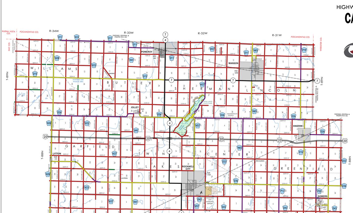
New description- US 20 and its
extensions in Calhoun County described as follows:
Beginning at the Calhoun-Sac
County line at the intersection of Dakota Avenue; then east following
substantially the center section line of Sections 7, 8, 9, 10, 11 and 12-T88N-R34W
to the intersection of Inwood Avenue; then easterly following the substantially
the center section of Sections 7,8, 9 and 10-T88N-R33W to the junction of Iowa
4; then east through Sections 11, and 12-T88N-R33W, and
continuing east through Sections 7, 8, 9, 10, 11, and 12‑T88N‑R32W,
and continuing east through Sections 7, 8, 9, 10, 11, and 12-T88N-R31W to the
Calhoun-Webster County Line, a point near the NE corner of the SE Quarter of
Section 12, Calhoun County (NW corner of the SW Quarter of Section 7‑T88N‑R30W,
Webster County).
OFFICAL DESCRIPTION CHANGE
OFFICE: Transportation Data
EFFECTIVE DATE: 12-15-2010
COUNTY: Calhoun
ROUTE: US 20
ENTERED BY: Cheryl Cowie
ENTERED DATE: 3-1-2011
New description – US 20 and it’s extensions in Calhoun
County described as follows:
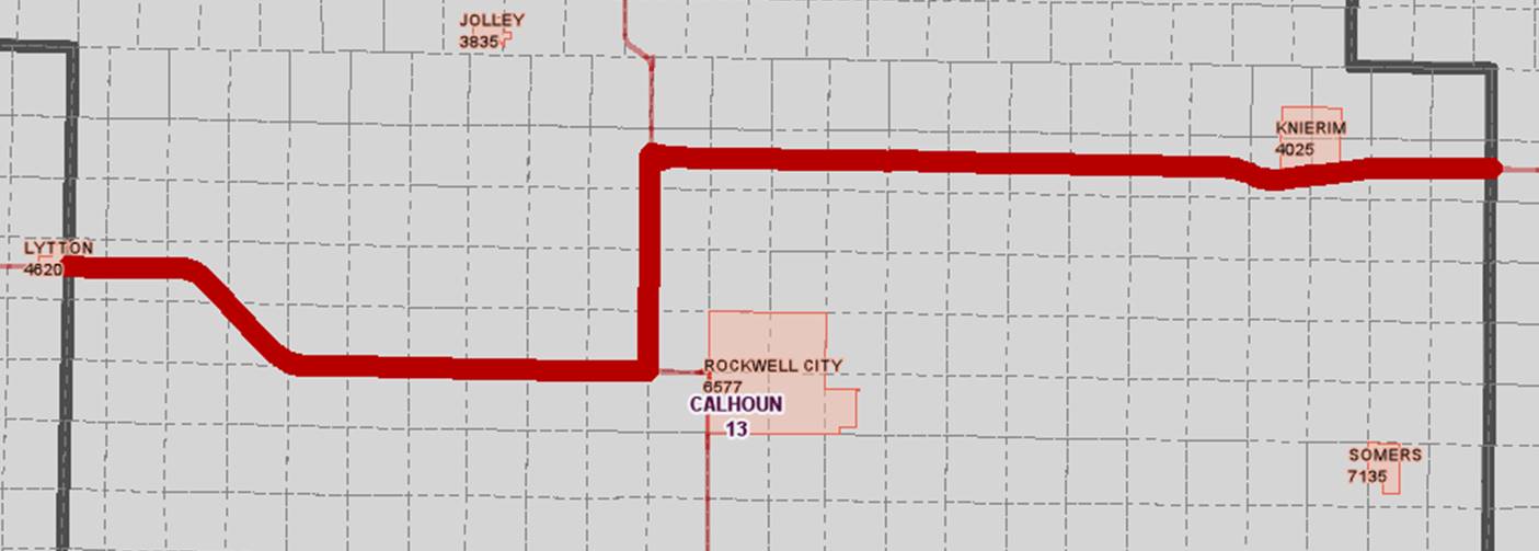
Lytton:
Beginning on
Beginning again at the east corporation line of Lytton
connecting with Railway Street: then east following substantially the center
section line of Sections 19, 20, and 21‑T88N‑R34W to a point
approximately 1,100 feet east of the west line of said Section 21‑T88N‑R34W;
thence in a southeasterly direction through Sections 21, 28, 27, and 26 to a
point approximately 400 feet east of the SW Corner of said Section 26‑T88N‑R34W;
thence east following substantially the section line through Sections 35 and 36‑T88N‑R34W
and Sections 31, 32, 33, 34 (west junction Iowa 4) and north along Iowa 4
following substantially the west section line of sections 26, 23, 14 and
11-T88N-R33W to NW corner of the SW quarter of Section 11, (north junction of
Iowa 4) then east through Sections 11, and 12-T88N-R33W, and continuing east
through Sections 7, 8, 9, 10, 11, and 12‑T88N‑R32W, and continuing
east through Sections 7, 8, 9, 10, 11, and 12-T88N-R31W to the Calhoun-Webster
County Line, a point near the NE corner of the SE Quarter of Section 12,
Calhoun County (NW corner of the SW Quarter of Section 7‑T88N‑R30W,
Webster County).
OFFICAL DESCRIPTION CHANGE
COUNTY: Calhoun
ROUTE: US 20
STAFF ACTION NUMBER: S-87-693
APPROVAL DATE: 12-18-86
New description ‑ US 20 and its extensions in
Lytton:
Beginning on
Beginning again at the east corporation line of Lytton
connecting with Railway Street: then east following substantially the center
section line of Sections 19, 20, and 21‑T88N‑R34W to a point
approximately 1,100 feet east of the west line of said Section 21‑T88N‑R34W;
thence in a southeasterly direction through Sections 21, 28, 27, and 26 to a
point approximately 400 feet east of the SW Corner of said Section 26‑T88N‑R34W;
thence east following substantially the section line through Sections 35 and 36‑T88N‑R34W
and Sections 31, 32, 33, 34 (west junction Iowa 4) and 35‑T88N‑R33W
(east junction of Iowa 4) to the west corporation line of Rockwell City
connecting with High Street.
Beginning on High Street at the west corporation line;
thence east on High Street to the east corporation line.
Beginning again on the east corporation line of Rockwell
City connecting with High Street; thence in an easterly and southeasterly
direction through Section 29‑T88N‑R32W to a point approximately 400
feet west of the S ¼ Corner of Section 29‑T88N‑R32W; thence east
following substantially the section line of Sections 32, 33, 34, 35 and 36‑T88N‑R32W;
and Sections 31, 32, 33, 34, 35 and 36‑T88N‑R31W to the Calhoun‑Webster
County line at a point near the NE Corner of Section 36‑T88N‑R31W,
Calhoun County (NW Corner of Section 31‑T88N‑R30W, Webster County).
COMMISSION ORDER
DIVISION: Planning &
Research
COMMISSION ORDER NUMBER:
PR-79-272
SUBMITTED BY: C.I.
MacGillivray
MEETING DATE: 11-2-78
DISCUSSION/BACKGROUND:
Due to the review of our Primary Road System records, US
20 in Calhoun County should be deleted and the new description added should be
officially included into the Primary Road System.
US 20 begins at the Calhoun‑Sac County line on the
east corporation line of Lytton, Iowa and travels in an easterly direction via
Rockwell City, Iowa to the Calhoun‑Webster County line approximately 1
mile north and 2 miles east of Somers, Iowa.
PROPOSAL/ACTION RECOMMENDATION:
Locate US 20 and its extension in
Beginning on the east corporation line of the City of
Lytton connecting with unnamed street; (Calhoun‑Sac County Line) thence
in an easterly direction through Sections 19, 20, and 21‑T88N‑R34W
to a point approximately 1,100 feet east of the west line of said Section 21‑T88N‑R34W:
thence in a southeasterly direction through Sections 21, 28, 27, and 26 to a
point approximately 400 feet east of the SW Corner of said Section 26‑T88N‑R34W;
thence east following substantially the section line through 35 and 36‑T88N‑R34W
and Sections 31, 32, 33, 34 (west junction Iowa 4) and 35‑T88N‑R33W
(east junction of Iowa 4) to the west corporation line of the City of Rockwell
City connecting with unnamed street.
Beginning at the west corporation line connecting with
an unnamed street; thence easterly to unnamed street; thence northeasterly on
unnamed street to a point on the east corporation line.
Beginning again on the east corporation line of the City
of Rockwell City connecting with an unnamed street; thence in an easterly and
southeasterly direction through Section 29‑T88N‑R32W to a point
approximately 400 feet west of the S ¼ Corner of Section 29‑T88N‑R32W;
thence east following substantially the section line of Sections 32, 33, 34, 35
and 36‑T88‑R32; and Sections 31, 32, 33, 34, 35 and 36-T88‑R31
to the Calhoun‑Webster County line at a point near the NE Corner of
Section 36, Calhoun County (NW Corner of Section 31‑T88‑R30,
Webster County).
NOW, THEREFORE: Be it resolved that the Iowa Department
of Transportation approve the location of US 20 in Calhoun County,
NOTE: To become effective upon adoption of this
resolution.
REVISED: 12-18-86
COMMISSION ORDER
DIVISION: Planning &
Research
SUBMITTED BY: Raymond L.
Kassel
MEETING DATE: 8-24-76
DISCUSSION/BACKGROUND:
Due to the review of our Primary Road System records, US
20 in Calhoun County should be deleted and the new description added should be
officially included into the Primary Road System.
US 20 begins at the Calhoun‑Sac County line on the
east corporation line of Lytton, Iowa and travels in an easterly direction via
Rockwell City, Iowa to the Calhoun‑Webster County line approximately 1
mile north and 2 miles east of Somers, Iowa.
PROPOSAL/ACTION RECOMMENDATION:
Locate US 20 and its extension in
Beginning on the east corporation line of the City of
Lytton connecting with unnamed street; (Calhoun‑Sac County Line) thence
in an easterly direction on the north side of and substantially parallel to
the Chicago, Milwaukee, St. Paul & Pacific Railroad through Sections 19,
20, and 21‑T88N‑R34W to a point approximately 1,100 feet east of
the west line of said Section 21‑T88N‑R34W; thence in a
southeasterly direction through Sections 21, 28, 27, and 26 to a point
approximately 400 feet east of the SW Corner of said Section 26‑T88N‑R34W;
thence east following substantially the section line through 35 and 36‑T88N‑R34W
and Sections 31, 32, 33, 34 (west junction Iowa 4) and 35‑T88N‑R33W
(east junction of Iowa 4) to the west corporation line of the City of Rockwell
City connecting with unnamed street.
Beginning at the west corporation line connecting with
an unnamed street; thence easterly to unnamed street; thence northeasterly on
unnamed street to a point on the east corporation line.
Beginning again on the east corporation line of the City
of Rockwell City connecting with an unnamed street; thence in an easterly and
southeasterly direction through Section 29‑T88N‑R32W to a point
approximately 400 feet west of the S ¼ Corner of Section 29‑T88N‑R32W;
thence east following substantially the section line of Sections 32, 33, 34, 35
and 36‑T88‑R32; and Sections 31, 32, 33, 34, 35 and 36-T88‑R31
to the Calhoun‑Webster County line at a point near the NE Corner of
Section 36, Calhoun County (NW Corner of Section 31‑T88‑R30,
Webster County).
NOW, THEREFORE: Be it resolved that the Iowa Department
of Transportation approve the location of US 20 in Calhoun County,
NOTE: To become effective upon adoption of this
resolution.
OFFICAL DESCRIPTION CHANGE
COUNTY: Calhoun
APPROVAL DATE: 12-31-68
Connecting Curves
Junction of
Beginning at a point approximately 700 feet west of the
SE Corner Section 27‑T88N‑R33W; thence curving in a northeasterly
direction to a point approximately 700 feet north of the SE Corner Section 27‑T88N‑R33W.
OFFICAL DESCRIPTION CHANGE
COUNTY: Calhoun
ROUTE: US 20
APPROVAL DATE: 1-18-39
Beginning on the east corporation line of the Town of
Lytton connecting with Railway Street; thence in an easterly direction on the
north side of and substantially parallel to the Chicago, Milwaukee, St. Paul
and Pacific Railroad to a point approximately 1,100 feet east of the west line
of Section 21‑T88N‑R34W; thence in a southeasterly direction
through Section 21, 28, 27, and 26, to a point approximately 400 feet east of
the SW Corner of Section 26‑T88N‑R34W; thence east following
substantially the section line to the west corporation line of the City of
Rockwell city connecting with High Street.
Beginning again on the east corporation line of the City
of Rockwell City connecting with an unnamed street; thence in an easterly and
southeasterly direction to a point approximately 400 feet west of the S ¼
Corner of Section 29‑T88N‑R32W; thence east following substantially
the section line to the Calhoun‑Webster County line at a point near the
SE Corner of Section 25‑T88N‑R31W, Calhoun County (SW Corner of
Section 30‑T88N‑R30W, Webster County).
OFFICAL DESCRIPTION CHANGE
COUNTY: Calhoun
ROUTE: US 20
APPROVAL DATE: 1-18-39
Beginning on the east corporation line of the town of
Lytton connecting with Railway Street at a point approximately 200 feet north
of the east and West quarter line of Sec. 19-T88-R34; thence in an easterly
direction on the north side of and substantially parallel to the C.M. ST. P.
& P. railroad to a point approximately 1100 feet east of the west line of
Sec. 21-T88-R34; thence in a southeasterly direction thru Sec. 21, 28, and 26,
to a point approximately 400 feet east of the SW corner of Sec. 26-T88-R34;
thence east following substantially the section line to the west corporation
line of the City of Rockwell City connecting with High Street.
Beginning again on the east corporation line of the City
of Rockwell City connecting with an unnamed street at a point approximately 500
feet north of the SW corner of Sec. 29-T88-R32; thence in a easterly and
southeasterly direction to a point approximately 400 feet west of the S. ½
corner of Sec. 29-T88-R32; thence east following substantially the section line
to the Calhoun-Webster County line at a point near the SE corner of Sec.
25-T88-R31, Calhoun County (SW corner of Sec. 30-T88-R30, Webster County).
OFFICAL
DESCRIPTION CHANGE
COUNTY: Calhoun
CITY OF:
ROUTE: US 20
APPROVAL DATE: 12-6-38
Commencing on High Street at the west corporation line;
thence east on High Street to a point approximately 537 feet east of
REVISED: 8-24-76
OFFICAL DESCRIPTION CHANGE
COUNTY: Calhoun
ROUTE: US 20
APPROVAL DATE: Adopted by
Commission 04-14-37 further action by Commission 01-18-39
Beginning on the Calhoun-Sac County line at a point near
the W. ¼ Cor. of Sec. 19-T88-R34, Calhoun County (E ¼ Cor. of Sec. 24-T88-R35,
Sac County), thence south along the Calhoun-Sac County line to a point near the
SW Cor. of Sec. 30-T88-R34, Calhoun County (SW Cor. of Sec. 25-T88-R35, Sac
County) thence east following substantially the section line to the west
corporation line of the City of Rockwell City connecting with High Street.
Beginning again on the east corporation line of the City
of Rockwell City connecting with an unnamed street at a point approximately 500
feet north of the SW Cor. of Sec. 29-T88-R32 thence in an easterly and
southeasterly direction to a point approximately 400 feet west of the S ¼ Cor.
of Sec. 29-T88-R32, thence east following substantially the section line to a
the Calhoun-Webster County line at a point near the SE Cor. of Sec. 25-T88-R31,
Calhoun County (SW Cor. of Sec. 30-T88-R30, Webster County)
OFFICAL
DESCRIPTION CHANGE
COUNTY: Calhoun
CITY OF:
ROUTE: Iowa 20
APPROVAL DATE: 4-14-37
Connecting curves
Junction of Primary Road No. 17 and Primary Road No.
U.S. 20
Beginning at a point approximately 700 feet west of the
SE cor. of Sec. 27-T88-R33, thence curving in a northeasterly direction to a
point approximately 700 feet north of the SE Cor. of Sec. 27-T88-R33.
OFFICAL
DESCRIPTION CHANGE
COUNTY: Calhoun
CITY OF: Lytton
ROUTE: US 20
APPROVAL DATE: 12-20-36
Commencing on Railway Street at the west corporation
line; thence easterly on Railway Street crossing the Sac‑Calhoun County
line to the east corporation line.