OFFICIAL
DESCRIPTION CHANGE
OFFICE: Research and Analytics
EFFECTIVE DATE: 12-15-2010
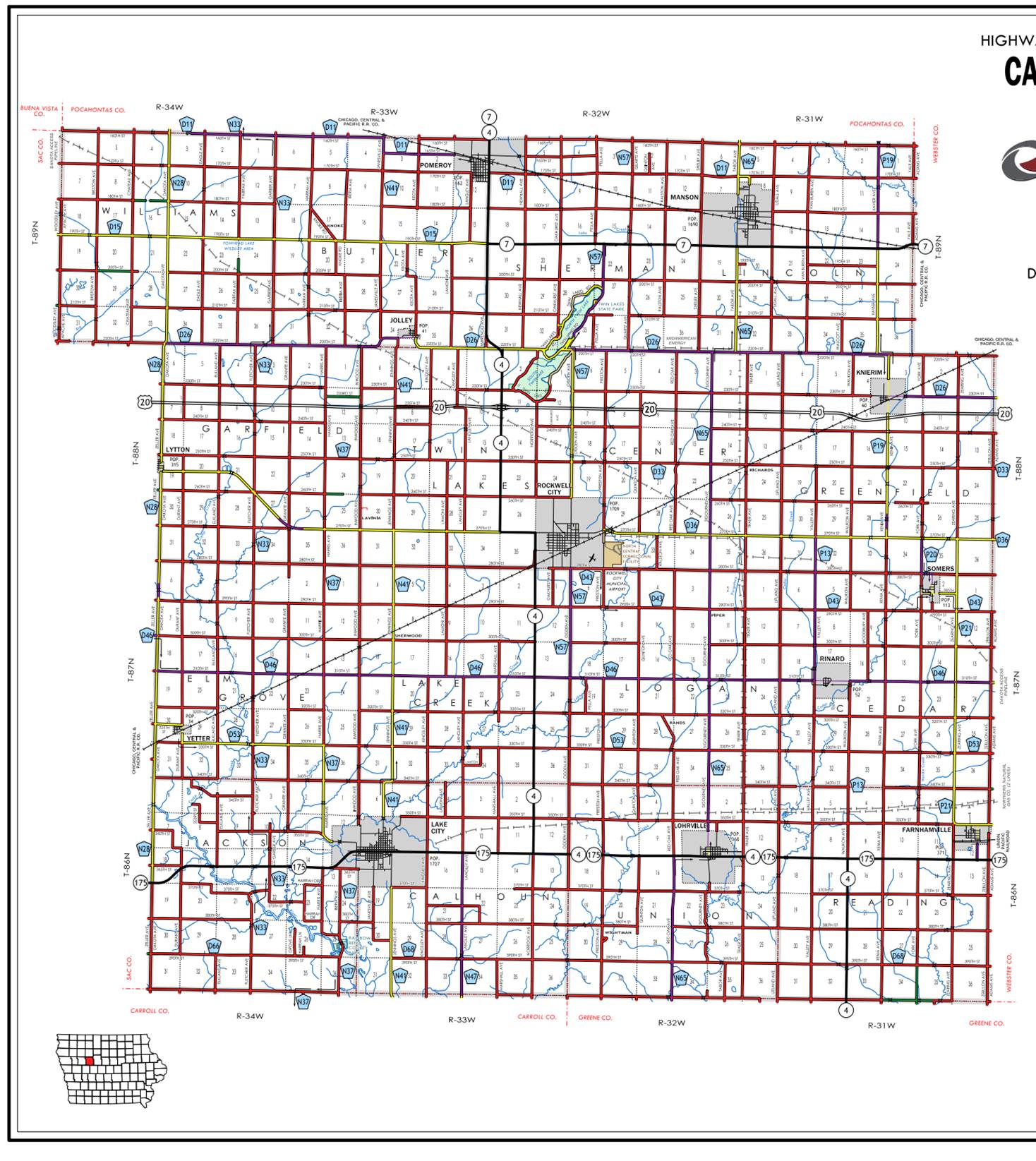
COUNTY: Calhoun
ROUTE: Iowa 4
ENTERED BY: Paul Mauer
ENTERED DATE: 10-25-2019
New description ‑
Beginning on the Calhoun‑Greene County line at the
SW Corner Section 33‑T86N‑R31W, Calhoun County (NW Corner Section 4‑T85N‑R31W,
Greene County); thence north following substantially the section line through
Sections 33, 28, 21, and 16‑T86N‑R31W (east junction Iowa 175);
thence west following substantially the Section line through Sections 17 and 12‑T86N‑R31W;
thence Section 13‑T86N‑R32W to the east corporation line of Lohrville connecting with 5th Street.
Lohrville:
Beginning on
Beginning again at the west corporation line of Lohrville, connecting with 5th Street; thence west
following substantially the section line of Sections 16, 17 and 18‑T86N‑R32W
and Section 13‑T86N‑R33W to a point near the NW Corner of Section
13‑T86N-R33W (west junction Iowa 175); thence north following
substantially the section line of Sections 12 and 1‑T96N‑R33W and
Sections 36, 25, 24, 13, 12, and 1‑T87N‑R33W and Section 36‑T88N‑R33W
to a point approximately 500 feet south of the NW Corner of Section 36‑T88N‑R33W:
then curving in a northwesterly direction though Section 35‑T88N-R33W to
a point approximately 650 feet west of the NE Corner of Section 35‑T88N‑R33W
at the intersection of High Street; thence west following substantially the
section line of Section 35‑T88N‑R33W to a point near the NW Corner
Section 35‑T88N‑R33W at the intersection of 270th
Street; thence north following substantially the section line of Sections 26,
23, 14, 11(junction US 20), and 2‑T88N‑R33W to a point
approximately 1200 feet south of the NW Corner of Section 2‑T88N‑R33W;
thence northwesterly through Section 3‑T88N‑R33W and Section 31‑T89N‑R32W
to a point approximately 2200 feet north of the SW Corner Section 31‑T89N‑R32W;
thence north following substantially the section line of Sections 31, 30, 19,
18 (south junction of Iowa 7) and 7‑T89N‑R32W to the south
corporation line of Pomeroy connecting with East Street.
Pomeroy:
Beginning on
OFFICAL DESCRIPTION CHANGE
COUNTY: Calhoun
ROUTE:
STAFF ACTION NUMBER: S-87-693
APPROVAL DATE: 12-18-86
New description ‑
Beginning on the Calhoun‑Greene County line at the
SW Corner Section 33‑T86N‑R31W, Calhoun County (NW Corner Section 4‑T85N‑R31W,
Greene County); thence north following substantially the section line through
Sections 33, 28, 21, and 16‑T86N‑R31W (east junction Iowa 175);
thence west following substantially the Section line through Sections 17 and 12‑T86N‑R31W;
thence Section 13‑T86N‑R32W to the east corporation line of
Lohrville connecting with 5th Street.
Lohrville:
Beginning on
Beginning again at the west corporation line of
Lohrville, connecting with 5th Street; thence west following substantially the
section line of Sections 16, 17 and 18‑T86N‑R32W and Section 13‑T86N‑R33W
to a point near the NW Corner of Section 13‑T86N-R33W; thence north
following substantially the section line of Sections 12 and 1‑T96N‑R33W
and Sections 36, 25, 24, 13, 12, and 1‑T87N‑R33W and Section 36‑T88N‑R33W
to a point approximately 500 feet south of the NW Corner of Section 36‑T88N‑R33W:
then curving in a northwesterly direction though Section 35‑T88N-R33W to
a point approximately 650 feet west of the NE Corner of Section 35‑T88N‑R33W
(east junction US 20); thence west following substantially the section line of
Section 35‑T88N‑R33W to a point near the NW Corner Section 35‑T88N‑R33W
(west junction of US 20); thence north following substantially the section line
of Sections 26, 23, 14, 11, and 2‑T88N‑R33W to a point
approximately 1200 feet south of the NW Corner of Section 2‑T88N‑R33W;
thence northwesterly through Section 3‑T88N‑R33W and Section 31‑T89N‑R32W
to a point approximately 2200 feet north of the SW Corner Section 31‑T89N‑R32W;
thence north following substantially the section line of Sections 31, 30, 19,
18 (south junction of Iowa 7) and 7‑T89N‑R32W to the south
corporation line of Pomeroy connecting with East Street.
Pomeroy:
Beginning on
COMMISSION ORDER
DIVISION: Planning &
Research
COMMISSION ORDER NUMBER:
PR-79-272
SUBMITTED BY: C.I.
MacGillivray
MEETING DATE: 11-2-78
DISCUSSION/BACKGROUND:
Due to the review of our Primary Road System records,
PROPOSAL/ACTION RECOMMENDATION:
Locate
Beginning on the Calhoun‑Greene County line at the
SW Corner Section 33‑T86N-R31W, Calhoun County (NW Corner Section 4‑T85N‑R31W,
Greene County); thence north following substantially the section line through
Sections 33, 28, 21, and 16‑T86N‑R31W (east junction Iowa 175);
thence westerly following substantially the section line through Sections 17
and 18‑T86N‑R31W; thence Section 13‑T86N-R32W to the east
corporation line of the City of Lohrville connecting with an unnamed street.
Lohrville:
Beginning on an unnamed street at the east corporation
limits; thence westerly on said unnamed street to the west corporation limits.
Beginning again at the west corporation line of the City
of Lohrville, connecting with an unnamed street; thence westerly following substantially
the section line of Sections 16, 17, and 18‑T86N‑R32W and Section
13‑T86N‑R33W to a point near the NW Corner of Section 13‑T86N‑R33W;
thence northerly following substantially the section line of Sections 12 and 1‑T86N‑R33W
and Section 36, 25, 24, 13, 12, and 1‑T87N‑R33W and Section 36‑T88N‑R33W
to a point approximately 500 feet south of the NW Corner of Section 36‑T88N-R33W;
thence curving in a northwesterly direction through Section 35-T88N‑R33W
to a point approximately 650 feet west of the NE Corner of Section 35‑T88N‑R33W
(east junction US 20); thence west following substantially the section line of
Section 35‑T88N‑R33W to a point near the NW Corner Section 35‑T88N-R33W
(west junction of US 20); thence north following substantially the section line
of Sections 26, 23, 14, 11, and 2‑T88N‑R33W to a point
approximately 1200 feet south of the NW Corner of Section 2‑T88N‑R33W;
thence northwesterly through Section 3‑T88N‑R33W and Section 31‑T89N‑R32W
to a point approximately 2200 feet north of the SW Corner Section 31‑T89N‑R32W;
thence north following substantially the section line of Sections 31, 30, 19,
18 (south junction of Iowa 7) and 7‑T89N‑R32W to the south
corporation line of the City of Pomeroy connecting with an unnamed street.
Pomeroy:
Beginning on an unnamed street at the south corporation
line; thence northerly to the north corporation line. (Calhoun‑Pocahontas
County line)
NOW, THEREFORE: Be it resolved that the Iowa Department
of Transportation approve the location of
NOTE: To become effective upon adoption of this
resolution.
REVISED: 12-18-86
COMMISSION ORDER
DIVISION: Planning &
Research
SUBMITTED BY: Raymond L.
Kassel
MEETING DATE: 8-24-76
DISCUSSION/BACKGROUND:
Due to the review of our Primary Road System records,
PROPOSAL/ACTION RECOMMENDATION:
Locate
Beginning on the Calhoun‑Greene County line at the
SW Corner Section 33-T86N-R31W, Calhoun County (NW Corner Section 4‑T85N‑R31W,
Greene County); thence north following substantially the section line through
Sections 33, 28, 21, and 16‑T86N‑R31W (east junction Iowa 175);
thence westerly following substantially the section line through Sections 17
and 18‑T86N‑R31W; thence Section 13-T86N-R32W to the east
corporation line of the City of Lohrville connecting with an unnamed street.
Lohrville:
Beginning on an unnamed street at the east corporation
limits; thence westerly on said unnamed street to the west corporation limits.
Beginning again at the west corporation line of the City
of Lohrville, connecting with an unnamed street; thence westerly following substantially
the section line of Sections 16, 17, and 18‑T86N‑R32W and Section
13‑T86N‑R33W to a point near the NW Corner of Section 13‑T86N‑R33W;
thence northerly following substantially the section line of Sections 12 and 1‑T86N‑R33W
and Section 36, 25, 24, 13, 12, and 1‑T87N‑R33W and Section 36‑T88N‑R33W
to a point approximately 500 feet south of the NW Corner of Section
36-T88N-R33W; thence curving in a northwesterly direction through Section 35T88N‑R33W
to a point approximately 650 feet west of the NE Corner of Section 35‑T88N‑R33W
(east junction US 20); thence west following substantially the section line of
Section 35‑T88N‑R33W to a point near the NW Corner Section 35‑T88N‑R33W
(west junction of US 20); thence north following substantially the section line
of Sections 26, 23, 14, 11, and 2‑T88N‑R33W to a point
approximately 1200 feet south of the NW Corner of Section 2‑T88N‑R33W;
thence northwesterly through Section 3‑T88N‑R33W and Section 31‑T89N‑R32W
to a point approximately 2200 feet north of the SW Corner Section 31‑T89N‑R32W;
thence north following substantially the section line of Sections 31, 30, 19,
18 (south junction of Iowa 7) and 7‑T89N‑R32W to the south
corporation line of the City of Pomeroy connecting with an unnamed street.
Pomeroy:
Beginning on an unnamed street at the south corporation
line; thence northerly to the north corporation line. (Calhoun‑Pocahontas
County line)
NOW, THEREFORE: Be it resolved that the Iowa Department
of Transportation approve the location of
NOTE: To become effective upon adoption of this
resolution.
OFFICAL DESCRIPTION CHANGE
COUNTY: Calhoun
ROUTE:
APPROVAL DATE: 12-31-68
Beginning on the Calhoun‑Greene County line at the
SE Corner Section 32‑T86N‑R31W; thence north following
substantially the section line to the NE Corner Section 17‑T86N‑R31W;
thence west following substantially the section line to the east corporation
line of the Town of
Lohrville:
Beginning on
Beginning again at the west corporation line of the Town
of Lohrville connecting with 5th Street; thence west following substantially
the section line to a point near the SW Corner Section 12‑T86N‑R33W;
thence north following substantially the section line to the NE Corner Section
35‑T88N‑R33W; thence west to a point near the SW Corner Section 26‑T88N‑R33W;
thence north following substantially the section line to a point approximately
1200 feet south of the NE Corner Section 3‑T88N‑R33W; thence NW in
Section 3‑T88N‑R33W and in Section 31‑T89N‑R32W to a
point approximately 2200 feet north of the SW Corner said Section 31; thence
north following substantially the section line to the south corporation line of
the Town of Pomeroy connecting with East Street.
Pomeroy:
Beginning on
REVISED: 8-24-76
OFFICAL DESCRIPTION CHANGE
COUNTY: Calhoun
APPROVAL DATE: 12-31-68
Connecting Curve
Junction
Beginning at a point approximately 500 feet west of the
SW Corner Section 12‑T86N‑R33W; thence curving in a northeasterly
direction to a point approximately 500 feet north of the SW Corner Section 12‑T86N‑R33W.
Junction of
Beginning at a point approximately 700 feet south of the
NW Corner Section 19‑T89N‑R32W; thence curving in a northeasterly
direction to a point approximately 700 feet east of the NW Corner Section 19‑T89N‑R32W.
Junction of
Beginning at a point approximately 700 feet west of the
SE Corner Section 27‑T88N‑R33W; thence curving in a northeasterly,
direction to a point approximately 700 feet north of the SE Corner Section 27‑T88N‑R33W.