OFFICIAL DESCRIPTION CHANGE
OFFICE: Research and Analytics
EFFECTIVE DATE: 12-31-2013
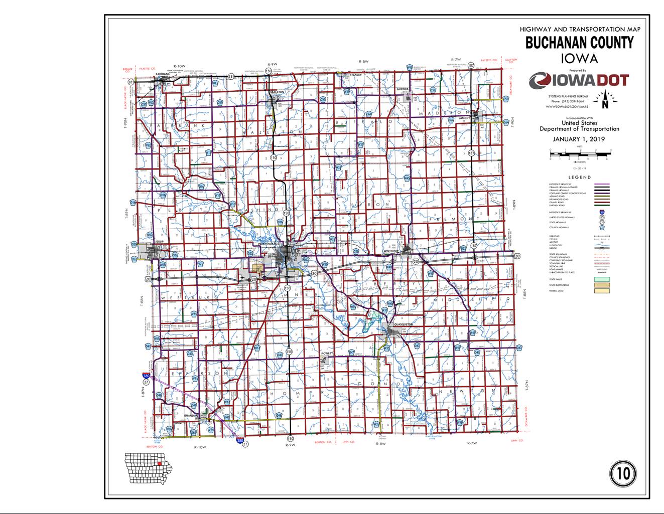
COUNTY: Buchanan
ROUTE: Iowa 150
ENTERED BY: Paul Mauer
ENTERED DATE: 1-30-2020
New
Description -
Beginning at the Buchanan-Benton County line at a point
near the SW Corner of Section 34-T87N-R9W, Buchanan County (NW Corner of
Section 3-T86N-R9W, Benton County); thence north through Section 33-T87N-R9W to
a point approximately 350 feet north of the SE Corner said Section 33; thence
north following substantially the section line of Sections 34, 27, 22, 15, 10,
and 3-T87N-R9W and Sections 34, 27, 22 and 15-T88-R9W to the south corporation
line of Independence connecting with 3rd Avenue Southeast.
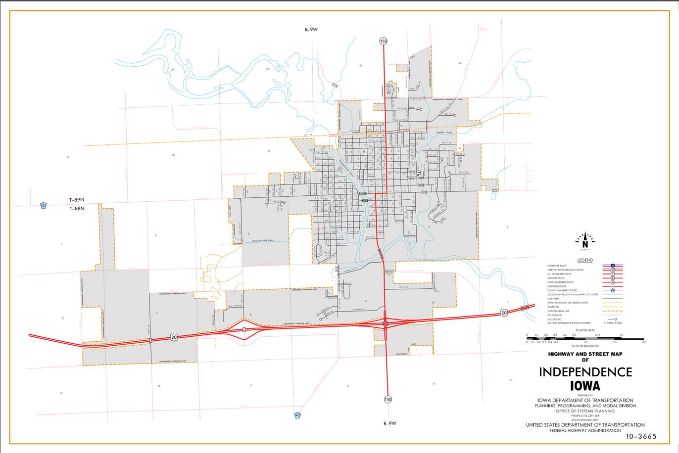
Beginning on 3rd Avenue Southeast at the south
corporation line; thence north on 3rd Avenue Southeast to the junction of US
20; thence continuing north to 1st Street East; thence east on 1st Street East
to 5th Avenue Northeast; thence north on 5th Avenue Northeast to the north
corporation line.
Beginning again at the north corporation line of
Independence connecting with 5th Avenue Northeast; thence north following
substantially the east quarter section line of Sections 27, 22, 15, and 10-T89N-R9W to a point
approximately 700 feet south of the NW Corner NE ¼ NE ¼ of Section 10-T89N-R9W;
thence curving in a northwesterly direction to a point approximately 700 feet
west of the NW Corner NE ¼ NE ¼ of Section 10-T89N-R9W; thence west following
substantially the section line said Section 10 to a point approximately 700
feet east of the SW Corner of Section 3-T89N-R9W; thence curving in a
northwesterly direction to a point approximately 700 feet north of the SW
Corner of Section 3-T89N-R9W; thence north following substantially the section
line of Section 3-T89N-R9W and Sections 34, 27 and to a point just north of the
NW Corner of Section 27-T90N-R9W; thence in a northeasterly and northerly
direction through Section 22-T90N-R9W and in a northwesterly direction through
Section 15-T90N-R9W to the south corporation line of Hazelton connecting with
Main Street.
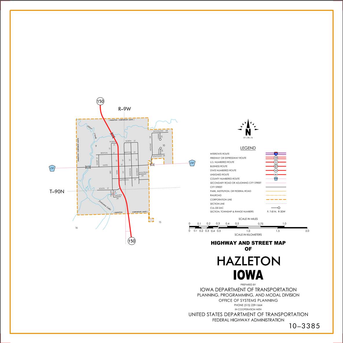
Hazelton:
Beginning on Main Street at the south corporation line;
thence northwesterly, northerly, northwesterly, and northerly on Main Street to
the north corporation line.
Beginning again on the north corporation line of
Hazelton connecting with Main Street; thence north following substantially the
east quarter section line of Sections 9 and 4-T90N-R9W to a point near the SW
Corner NE ¼ NE ¼ of Section 4-T90N-R9W; thence in a northwesterly direction
through said Section 4 to the Buchanan-Fayette County line at a point
approximately 300 feet west of the NW Corner NE ¼ NE ¼ of Section 4-T90N-R9W,
Buchanan County (SW Corner SE ¼ SE ¼ of Section 33-T91N-R9W, Fayette County).
STAFF ACTION
OFFICE: Transportation Inventory
STAFF
ACTION NUMBER:
S-95-569
SUBMITTAL
DATE:
10-11-94
DISCUSSION/BACKGROUND:
Due
to construction on
The
new section of
Transfer
of jurisdiction agreement number 91-TJ-017-10, between the Iowa Department of
Transportation and
The
section of old
PROPOSAL/ACTION
RECOMMENDATION:
It
is recommended the old description of
New
Description -
Beginning at the Buchanan-Benton County line at a point
near the SW Corner of Section 34-T87N-R9W, Buchanan County (NW Corner of
Section 3-T86N-R9W, Benton County); thence north through Section 33-T87N-R9W to
a point approximately 350 feet north of the SE Corner said Section 33; thence
north following substantially the section line of Sections 34, 27, 22, 15, 10,
and 3-T87N-R9W and Sections 34, 27, 22, 15, and 10-T88-R9W (south junction US
20) to the south corporation line of Independence connecting with 3rd Avenue.
Beginning on
Beginning again at the north corporation line of
Independence connecting with 5th Avenue; thence north following substantially
the east quarter section line of Sections 34, 27, 22, 15, and 10-T89N-R9W to a
point approximately 700 feet south of the NW Corner NE ¼ NE ¼ of Section
10-T89N-R9W; thence curving in a northwesterly direction to a point
approximately 700 feet west of the NW Corner NE ¼ NE ¼ of Section 10-T89N-R9W;
thence west following substantially the section line said Section 10 to a point
approximately 700 feet east of the SW Corner of Section 3-T89N-R9W; thence
curving in a northwesterly direction to a point approximately 700 feet north of
the SW Corner of Section 3-T89N-R9W; thence north following substantially the
section line of Section 3-T89N-R9W and Sections 34, 27 and to a point just
north of the NW Corner of Section 27-T90N-R9W; thence in a northeasterly and
northerly direction through Section 22-T90N-R9W and in a northwesterly
direction through Section 15-T90N-R9W to the south corporation line of Hazelton
connecting with new Main Street.
Hazelton:
Beginning on Main Street at the south corporation line;
thence northwesterly, northerly, northwesterly, and northerly on Main Street to
the north corporation line.
Beginning again on the north corporation line of
Hazelton connecting with Main Street; thence north following substantially the
east quarter section line of Sections 9 and 4-T90N-R9W to a point near the SW
Corner NE ¼ NE ¼ of Section 4-T90N-R9W; thence in a northwesterly direction
through said Section 4 to the Buchanan-Fayette County line at a point
approximately 300 feet west of the NW Corner NE ¼ NE ¼ of Section 4-T90N-R9W,
Buchanan County (SW Corner SE ¼ SE ¼ of Section 33-T91N-R9W, Fayette County).
OFFICIAL DESCRIPTION CHANGE
COUNTY: Buchanan
ROUTE:
STAFF ACTION NUMBER: S-87-690
APPROVAL DATE: 12-18-86
New Description ‑
Beginning at the Buchanan‑Benton County line at a
point near the SW Corner of Section 34‑T87N‑R9W, Buchanan County
(NW Corner of Section 3‑T86N‑R9W, Benton County); thence north
through Section 33‑T87N‑R9W to a point approximately 350 feet north
of the SE Corner said Section 33; thence north allowing substantially the
section line of Sections 34, 27, 22, 15, 10, and 3‑T87N‑R9W and
Sections 34, 27, 22, 15; and 10‑T88‑R9W (south junction US 20) to
the south corporation line of Independence connecting with 3rd Avenue.
Beginning on
Beginning again at the north corporation line of
Independence connecting with 5th Avenue; thence north following substantially
the east quarter section line of Sections 34, 27, 22, 15, and 10-T89N‑R9W
to a point approximately 700 feet south of the NW Corner NE ¼ NE ¼ of Section
10‑T89N‑R9W; thence curving in a northwesterly direction to a point
approximately 700 feet west of the NW Corner NE ¼ NE ¼ of Section 10‑T89N‑R9W;
thence west following substantially the section line said Section 10 to a point
approximately 700 feet east of the SW Corner of Section 3‑T89N‑R9W;
thence curving in a northwesterly direction to a point approximately 700 feet
north of the SW Corner of Section 3‑T89N‑R9W; thence north following
substantially the section line of Section 3‑T89N‑R9W and Sections
34, 27, and 22‑T90N‑R9W to a point approximately 700 feet south of
the W ¼ Corner of Section 22‑T90N‑R9W; thence in a northeasterly
and northerly direction through Section 22‑T90N‑R9W and in a northwesterly
direction through Section 15‑T90N‑R9W to a point approximately ¼
mile north of the SW Corner of Section 15‑T90N‑R9W; thence north
following substantially the section line of Section 15‑T90N-R9W to the
south corporation line of Hazelton connecting with Main Street.
Hazelton:
Beginning on Main Street at the south corporation line;
thence northwesterly, northerly, northwesterly, and northerly on Main Street to
the north corporation line.
Beginning again on the north corporation line of
Hazelton connecting with Main Street; thence north following substantially the
east quarter section line of Sections 9 and 4‑T90N‑R9W to a point
near the SW Corner NE ¼ NE ¼ of Section 4‑T90N‑R9W; thence in a
northwesterly direction through said Section 4 to the Buchanan-Fayette County
line at a point approximately 300 feet west of the NW Corner NE ¼ NE ¼ of
Section 4‑T90N‑R9W, Buchanan County (SW Corner SE ¼ SE ¼ of Section
33‑T91N‑R9W, Fayette County).
REVISED: 10-11-94
COMMISSION ORDER
DIVISION: Planning &
Research
COMMISSION ORDER NUMBER:
PR-79-272
SUBMITTED BY: C.I.
MacGillivray
MEETING DATE: 11-2-78
DISCUSSION/BACKGROUND:
Due to a review of our Primary Road System Records,
PROPOSAL/ACTION RECOMMENDATION:
It is recommended that the old description of
Locate
Beginning
at the Buchanan‑Benton County line at a point near the SW Corner of
Section 34‑T87N‑R9W, Buchanan County (NW Corner of Section 3-T86N-R9W,
Benton County); thence north through Section 33‑T87N‑R9W to a point
approximately 350 feet north of the SE Corner said Section 33; thence,
northerly following substantially the section line of Sections 34, 27, 22, 15,
and 10-T88N-R9W (south junction US 20) to the south corporation line of the
City of Independence connecting with an unnamed street.
Beginning
at the south corporation line connecting with an unnamed street; thence
northerly to the north corporation line connecting with an unnamed street.
Beginning
again at the north corporation line of the City of Independence connecting with
an unnamed street; thence north following substantially the east quarter
section line of Sections 34, 27, 22, 15, and 10‑T89N‑R9W to a point
approximately 700 feet south of the NW Corner NE ¼ NE ¼ of Section 10‑T89N‑R9W;
thence curving in a northwesterly direction to a point approximately 700 feet
west of the NW Corner N ¼ NE ¼ of Section 10‑T89N‑R9W; thence west
following substantially the section line said Section 10 to a point
approximately 700 feet east of the SW Corner of Section 3‑T89N‑R9W;
thence curving in a northwesterly direction to a point approximately 700 feet
north of the SW Corner of Section 3‑T89N‑R9W; thence north
following substantially the section line of Section 3‑T89N‑R9W and
Sections 34, 27, and 22‑T90N-R9W to a point approximately 700 feet south
of the W ¼ Corner of Section 22‑T90N‑R9W; thence in a northeasterly
and northerly direction through Section 22‑T90N‑R9W and in a
northwesterly direction through Section 15‑T90N-R9W to a point
approximately ¼ mile north of the SW Corner of Section 15‑T90N‑R9W;
thence north following substantially the section line of Section 15‑T90N‑R9W
to the south corporation line of the City of Hazleton connecting with an
unnamed street.
Hazelton:
Beginning on the south corporation line connecting with
an unnamed street; thence northwesterly, northerly, northwesterly, and
northerly to the north corporation line connecting with in unnamed street.
Beginning
again on the north corporation line of the City of Hazleton connecting with an
unnamed street; thence north following substantially the east quarter section
line of Sections 9 and 4‑T90N‑R9W to a point near the SW Corner NE
¼ NE ¼ of Section 4‑T90N‑R9W; thence in a northwesterly direction
through said Section 4 to the Buchanan‑Fayette County line at a point
approximately 300 feet west of the NW Corner NE ¼ NE ¼ of Section 4‑T90N‑R9W,
Buchanan County (SW Corner SE ¼ SE ¼ of Section 33‑T91N‑R9W,
Fayette County).
REVISED 12-18-86
COMMISSION
ORDER
DIVISION: Planning & Research
SUBMITTED
BY:
Raymond L. Kassel
MEETING
DATE: 8-10-76
DISCUSSION/BACKGROUND:
Due
to a review of our Primary Road System records,
Iowa
150 begins at the Buchanan‑Benton County line approximately 11 miles
south of Independence and travels northerly through the cities of Independence
and Hazelton to the Buchanan‑Fayette County line approximately 1 ¼ mile
north of Hazelton.
PROPOSAL/ACTION
RECOMMENDATION:
Locate
Beginning
at the Buchanan‑Benton County line at a point near the SW Corner of
Section 34‑T87N‑R9W, Buchanan County (NW Corner of Section 3‑T86N‑R9W,
Benton County); thence north following substantially the section line of
Sections 34, 27, 22, 15, 10, and 3‑T87N‑R9W continuing northerly
along the section line of Sections 34, 27, 22, 15, and 10‑T88N‑R9W
to the south corporation line of the City of Independence connecting with an
unnamed street.
Beginning
at the south corporation line connecting with an unnamed street; thence
northerly to the north corporation line connecting with an unnamed street.
Beginning
again at the north corporation line of the City of Independence connecting with
an unnamed street; thence north following substantially the east quarter line
of Sections 34, 27, 22, 15, and 10‑T89N‑R9W to a point
approximately 700 feet south of the NW Corner NE ¼ NE ¼ of Section 10‑T89N‑R9W;
thence curving in a northwesterly direction to a point approximately 700 feet
west of the NW Corner NE ¼ NE ¼ of Section 10-T89N-R9W; thence west to a point
approximately 700 feet east of the SW Corner of Section 3‑T89N‑R9W;
thence curving in a northwesterly direction to a point approximately 700 feet
north of the SW Corner of Section 3‑T89N‑R9W; thence north
following substantially the section line of Sections 3‑T89N‑R9W
continuing north following substantially the section line of Sections 34, 27,
and 22‑T90N‑R9W to a point approximately 700 feet south of the W ¼
Corner of Section 22‑T90N‑R9W; thence in a northeasterly and northerly
direction through Section 22‑T90N‑R9W and in a northwesterly
direction through Section 15‑T90N‑R9W to a point approximately ¼
mile north of the SW Corner of Section 15‑T90N‑R9W; thence north
following substantially the section line to the south corporation line of the
City of Hazleton connecting with an unnamed street.
Beginning
again on the north corporation line of the City of Hazleton connecting with an
unnamed street; thence north following substantially the east quarter line of
Section 9 and 4-T90N‑R9W to a point near the SW Corner NE ¼ NE ¼ of
Section 4‑T90N-R9W; thence in a northwesterly direction to the Buchanan-Fayette
County line at a point approximately 300 feet west of the NW Corner NE ¼ NE ¼
of Section 4‑T90N‑R9W, Buchanan County (SW Corner SE ¼ SE ¼ of
Section 33‑T91N‑R9W, Fayette County).
NOW,
THEREFORE: Be it resolved that the Iowa Department of Transportation approve
the location of
NOTE:
To become effective upon the adoption of this resolution.
OFFICIAL
DESCRIPTION CHANGE
COUNTY: Buchanan
ROUTE:
APPROVAL
DATE:
6-9-41
Beginning
on the Buchanan‑Benton County line at a point near the SW Corner of
Section 34‑T87N-R9W,
Beginning
again on the north corporation line of the city of Independence, connecting
with Fifth Avenue Northeast; thence north following substantially the east
quarter-quarter line of Section 34, 27, 22, 15 and 10‑T89N-R9W, to a
point approximately 700 feet south of the NW Corner NE ¼ NE ¼ of Section 10‑T89N-R9W;
thence curving in a northwesterly direction to a point approximately 700 feet
west of the NW Corner NE ¼ NE ¼ of Section 10‑T89N-R9W; thence west to a
point approximately 700 feet east of the SW Corner of Section 3‑T89N-R9W;
thence curving in a northwesterly direction to a point approximately 700 feet north
of the SW Corner of Section 3‑T89N-R9W; thence north following
substantially the section line to a point approximately 700 feet south of the W
¼ Corner of Section 22‑T90N-R9W; thence in a northeasterly and northerly
direction through Section 22‑T90N-R9W and in a northwesterly direction
through Section 15‑T90N-R9W to a point approximately ¼ mile north of the
SW Corner of Section 15‑T90N-R9W; thence north following substantially
the section line to the south corporation line of the Town of Hazleton connecting
with an unnamed street.
Beginning
again on the north corporation line of the Town of Hazleton connecting with an
unnamed street; thence north following substantially the east quarter-quarter
line of Section 9 and 4‑T90N-R9W, to a point near the SW Corner NE ¼ NE ¼
of Section 4‑T90N-R9W; thence in a northwesterly direction to the
Buchanan‑Fayette County line at a point approximately 300 feet west of
the NW Corner NE ¼ NE ¼ of Section 4‑T90N-R9W, Buchanan County (SW Corner
SE ¼ SE ¼ of Section 33‑T91N-R9W, Fayette County).
OFFICIAL
DESCRIPTION CHANGE
COUNTY: Buchanan
CITY
OF:
ROUTE:
APPROVAL
DATE:
6-9-41
Commencing
on Third Avenue Southeast at the south corporation line; thence northerly on
Third Avenue Southeast to Main Street; thence easterly on Main Street to Fifth
Avenue Northeast; thence northerly on Fifth Avenue Northeast to the north
corporation line.
OFFICIAL
DESCRIPTION CHANGE
COUNTY: Buchanan
CITY
OF: Hazelton
ROUTE:
APPROVAL
DATE: 2-5-36
Commencing
on unnamed street at the south corporation line on the east side of Section 16‑T90N‑R9W;
thence northwesterly on unnamed street to Main Street at the north side of said
Section 16; thence northerly on Main Street approximately ½ mile; thence
northwesterly and northerly on unnamed street to the north corporation line.
NOTE:
Revised from