OFFICIAL
DESCRIPTION CHANGE
OFFICE:
Transportation Data
ENTERED
BY: Stefani Wonders
ENTERED
DATE: 09-14-2006
DISCUSSION/BACKGROUND:
Due to a
review of our Primary System records, the primary route description for
Interstate 80 in
PROPOSAL/ACTION
RECOMMENDATION:
New
Description - Interstate 80 and its extensions in
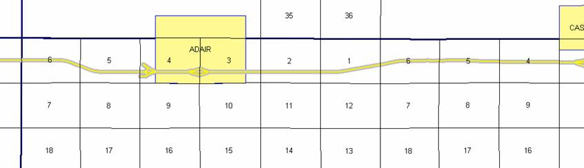
Beginning on the Adair‑Cass County
line at a point near the W ¼ Corner Section 6‑T77N‑R33W, Adair
County (E ¼ Corner Section 1‑T77N‑R34W, Cass County); thence
easterly and southeasterly through Section 6‑T77N‑R33W; thence southeasterly
and easterly through Section 5‑T77N‑R33W to a point 1298 feet north
of the SE Corner of said Section 5; thence easterly following substantially the
south quarter section line Section 4‑T77N‑R33W to the west
corporation line of the City of Adair connecting with an unnamed street (approximately
1298 feet north and 1770 feet east of the SW Corner of said Section 4).
Adair:
Beginning on an unnamed street at
the west corporation line; thence easterly on said unnamed street to the east
corporation line (approximately 1277 feet north and 1740 feet west of the SE
Corner Section 3-T77N-R33W).
Beginning again on the east
corporation line of the City of Adair connecting with an unnamed street; thence
easterly following substantially the south quarter section line through
Sections 3 and 2‑T77N‑R33W to a point 1306 feet north of the SE
Corner Section 2‑T77N‑R33W; thence easterly and northeasterly
through Section 1‑T77N‑R33W; thence northeasterly and easterly
through Section 6‑T77N‑R32W to a point 33 feet south of the E ¼
Corner of said Section 6; thence easterly following approximately the center
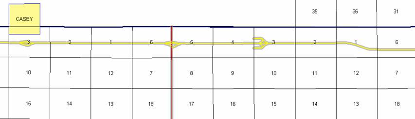
section line through Sections 5, 4, 3, 2 and 1‑T77N‑R32W and Sections
6 (junction Iowa 25), 5, 4, 3 and 2‑T77N‑R31W to a point near the E
¼ Corner Section 2‑T77N‑R31W; thence easterly, southeasterly and
easterly through Section 1‑T77N‑R31W to a point 1335 feet north of
the SE Corner of said Section 1; thence easterly following approximately the
south quarter section line through Sections 6 and 5-T77N-R30W to the west
corporation line of the City of Stuart connecting with an unnamed street
(approximately 1326 feet north of the SW Corner said Section 5).
Stuart:
Beginning on an unnamed street at the
west corporation line; thence easterly on said unnamed street to the east
corporation line (approximately 1314 feet north of the S ¼ Corner Section
4-T77N-R30W).
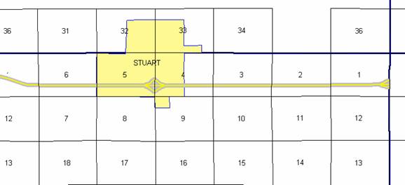
Beginning again on the east
corporation line of the City of Stuart connecting with an unnamed street;
thence easterly following substantially the south quarter section line of
Sections 4, 3, 2 and 1‑T77N‑R30W to the Adair‑Madison county
line at a point 1428 feet north of the SE Corner Section 1-T77N-R30W, Adair
County (SW Corner Section 6‑T77N‑R29W, Madison County).
COMMISSION ORDER
DIVISION: Planning & Research
COMMISSION ORDER
NUMBER: PR-81-677
SUBMITTED BY: Patrick R. Cain
MEETING DATE:
2-28-81
DISCUSSION/BACKGROUND:
Due to a review of our primary road
system records, Interstate 80 in
Interstate 80 begins at the Adair‑Cass
County line approximately three miles west of the City of
PROPOSAL/ACTION RECOMMENDATION:
It is recommended the commission
approve deleting the present description of Interstate 80 in
Locate Interstate 80 and its
extensions in
Beginning on the Adair‑Cass
county line at a point 15 feet south of the W ¼ Corner Section 6‑T77N‑R33W,
Adair County (E ¼ Corner Section 1‑T77N‑R34W, Cass County); thence
easterly and southeasterly through Section 6‑T77N‑R33W, and‑southeasterly
and easterly through Section 5‑T77N‑R33W to a point 1298 feet north
of the SE Corner of said Section 5; thence east following substantially the
south quarter section line Section 4‑T77N‑R33W to the west
corporation line of the City of Adair connecting with an unnamed street.
Adair:
Beginning at the west corporation
line, connecting with an unnamed street; thence easterly to the east
corporation line connecting with an unnamed street.
Beginning again on the east
corporation line of the City of Adair connecting with an unnamed street; thence
east following substantially the south quarter section line through Sections 3
and 2‑T77N‑R33W to a point 1306 feet north of the SE Corner Section
2‑T77N‑R33W; thence easterly and northeasterly through Section 1‑T77N‑R33W,
and northeasterly and easterly through Section 6‑T77N‑R32W to a
point 33 feet south of the E ¼ Corner of said Section 6; thence easterly
following approximately the center section line through Sections 5, 4, 3, 2 and
1‑T77N‑R32W; thence Sections 6 (junction Iowa 25), 5, 4, 3 and 2‑T77N‑R31W
to a point 197 feet south of the E ¼ Corner Section 2‑T77N‑R31W;
thence easterly, southeasterly and easterly through Section 1‑T77N‑R31W
to a point 1335 feet north of the SE Corner of said Section 1; thence easterly
following approximately the south quarter section line through Sections 6 and
5-T77N-R30W to the west corporation line of the City of Stuart connecting with
an unnamed street.
Stuart:
Beginning on the west corporation
line connecting with an unnamed street; thence easterly to the east corporation
line connecting with an unnamed street.
Beginning again on the east
corporation line of the City of Stuart connecting with an unnamed street;
thence easterly following substantially the south quarter section line of
Sections 4, 3, 2 and 1‑T77N‑R30W to the Adair‑Madison county
line at a point 1428 feet north of the SE Corner Section 1-T77N-R30W, Adair
County (SW Corner Section 6‑T77N‑R29W, Madison County).
COMMISSION ORDER
DIVISION: Planning & Research
COMMISSION ORDER
NUMBER: PR-79-272
SUBMITTED BY: C.I. MacGillivray
MEETING DATE:
11-2-78
DISCUSSION/BACKGROUND:
Due to a review of our Primary Road
System records, Interstate 80 in
Interstate 80 begins at the Adair‑Cass
County line approximately 2 ¼ miles west of Adair and travels in an easterly
direction to the
PROPOSAL/ACTION RECOMMENDATION:
Locate Interstate 80 and its
extension in
Beginning on the Adair‑Cass
County line at a point 15 feet south of the W ¼ Corner Section 6‑T77N‑R33W,
Adair County (E ¼ Corner Section 1‑T77N‑R34W, Cass County); thence
easterly and southeasterly through Section 6‑T77N‑R33W, and
southeasterly and easterly through Section 5‑T77N‑R33W to a point
1298 feet north of the SE Corner of said Section 5; thence east following
substantially the south quarter section line through Section 4‑T17N‑R33W
to the west corporation line of the City of Adair connecting with an unnamed
street.
Adair:
Beginning at the west corporation
line, connecting with an unnamed street; thence easterly to the east
corporation line connecting with an unnamed street.
Beginning again on the east corporation
line of the City of Adair connecting with an unnamed street; thence east
following substantially the south quarter section line through Sections 3 and 2‑T77N‑R33W
to a point 1306 feet north of the SE Corner Section 2‑T77N‑R33W;
thence easterly and northeasterly through Section 1‑T77N‑R33W, and
northeasterly and easterly through Section 6‑T77N‑R32W to a point
33 feet south of the E ¼ Corner of said Section 6; thence easterly following
approximately the center section line through Sections 5, 4, 3, 2, and 1‑T77N‑R32W;
thence Sections 6 (junction Iowa 25), 5, 4, and 3‑T77N‑R31W to a
point 197 feet south of the E ¼ Corner Section 2‑T77N‑R31W; thence
easterly, southeasterly, and easterly through Section 1‑T77N‑R31W
to a point 1335 feet north of the SE Corner of said Section 1; thence easterly
following approximately the south quarter section line through Sections 6, 5,
4, 3, 2, and 1‑T77N‑R30W to the Adair-Madison County line at a
point 1428 feet north of the SE Corner Section 1‑T77N-R30W, Adair County
(SW Corner Section 6-T77N‑R29W, Madison County).
NOW, THEREFORE: Be it resolved that
the Iowa Department of Transportation approve the location of Interstate 80 in
NOTE: To become effective upon the
adoption of this resolution.
REVISED: 4-28-81
COMMISSION ORDER
DIVISION: Planning & Research
SUBMITTED BY: Raymond L. Kassel
MEETING DATE: 8-24-76
DISCUSSION/BACKGROUND:
Due to a review of our Primary Road
System records, Interstate 80 in
Interstate 80 begins at the Adair‑Cass
County line approximately 2 ¼ miles west of Adair and travels in an easterly
direction to the Adair‑Madison County line approximately 4 miles
southeast of
PROPOSAL/ACTION RECOMMENDATION:
Locate Interstate 80 and its
extension in
Beginning on the Adair‑Cass
County line at a point 15 feet south of the W ¼ Corner Section 6‑T77N‑R33W,
Adair County (E ¼ Corner Section 1‑T77N‑R34W, Cass County); thence
easterly and southeasterly through Section 6‑T77N‑R33W, and
southeasterly and easterly through Section 5‑T77N‑R33W to a point
1298 feet north of the SE Corner of said Section 5; thence east following
substantially the south quarter section line through Section 4‑T17N‑R33W
to the west corporation line of the City of Adair connecting with an unnamed
street.
Adair:
Beginning at the west corporation
line, connecting with an unnamed street; thence easterly to the east
corporation line connecting with an unnamed street.
Beginning again on the east
corporation line of the City of Adair connecting with an unnamed street; thence
east following substantially the south quarter section line through Sections 3
and 2‑T77N‑R33W to a point 1306 feet north of the SE Corner Section
2‑T77N‑R33W; thence easterly and northeasterly through Section 1‑T77N‑R33W,
and northeasterly and easterly through Section 6‑T77N‑R32W to a
point 33 feet south of the E ¼ Corner of said Section 6; thence easterly
following approximately the center section line through Sections 5, 4, 3, 2,
and 1‑T77N‑R32W; thence Sections 6 (junction Iowa 25), 5, 4, and
3-T77N‑R31W to a point 197 feet south of the E ¼ Corner Section 2‑T77N‑R31W;
thence easterly, southeasterly and easterly through Section 1‑T77N‑R31W
to a point 1335 feet north of the SE Corner of said Section 1; thence easterly
following approximately the south quarter section line through Sections 6, 5,
4, 3, 2, and 1‑T77N‑R30W to the Adair-Madison County line at a
point 1428 feet north of the SE Corner Section 1-T77N-R30W, Adair County (SW
Corner Section 6-T77N‑R29W, Madison County).
NOW, THEREFORE: Be it resolved that
the Iowa Department of Transportation approve the location of Interstate 80 in
NOTE: To become effective upon the adoption of this
resolution.
COMMISSION RESOLUTION
DIVISION: Planning & Research
COMMISSION ORDER
NUMBER: 74-776
SUBMITTED BY: Gene R. Mills
MEETING DATE:
6-26-74
Locate Interstate 80 and its
extension in
Beginning on the Adair‑Cass
County line at a point 15 feet south of the W ¼ Corner Section 6‑T77N‑R33W,
Adair County (E ¼ Corner Section 1‑T77N‑R34W, Cass County); thence
easterly and southeasterly through Section 6‑T77N‑R33W, and
southeasterly and easterly through Section 5‑T77N‑R33W to a point
1298 feet north of the SE Corner of said Section 5; thence east following
substantially the quarter-quarter section line to the west corporation line of
the Town of Adair connecting with an unnamed street.
Adair:
Commencing
on an unnamed street (Interstate 80) at the west corporation line; thence east
on unnamed street (Interstate 80) to the east corporation line.
Beginning again on the east
corporation line of the Town of Adair connecting with an unnamed street; thence
east following substantially the quarter‑quarter section line to a point
1306 feet north of the SE Corner Section 2‑T77N‑R33W; thence easterly
and northeasterly through Section 1‑T77N‑R33W, and northeasterly
and easterly through Section 6‑T77N‑R32W to a point 33 feet south
of the E ¼ Corner of said Section 6; thence easterly following approximately
the quarter section line to a point 197 feet south of the E ¼ Corner Section 2‑T77N‑R31W;
thence easterly, southeasterly, and easterly through Section 1‑T77N‑R31W
to a point 1335 feet north of the SE Corner of said Section 1; thence easterly
following approximately the quarter‑quarter section line to the Adair‑Madison
County line at a point 1428 feet north of the SE Corner Section 1‑T77N‑R30W,
Adair County (SW Corner Section 6-T77N‑R29W, Madison County).
NOW, THEREFORE: Be it resolved that the Iowa State Highway
Commission approve the location of Interstate 80 in
OFFICIAL DESCRIPTION CHANGE
COUNTY: Adair
ROUTE: Interstate 80
APPROVAL DATE: 3-11-59
Beginning on the Adair‑Cass
County line at a point 15 feet south of the W ¼ Corner Section 6‑T77N‑R33W,
Adair County (E ¼ Corner Section 1‑T77N‑R34W, Cass County): thence
easterly and southeasterly thru Section 6‑T77N‑R33W, and
southeasterly and easterly thru Section 5‑T77N‑R33W to a point 1298
feet north of the SE Corner of said Section 5; thence east following
substantially the quarter‑quarter section line to a point 1306 feet north
of the SE Corner Section 2‑T77N‑R33W; thence easterly and
northeasterly thru Section 1‑T77N‑R33W and northeasterly and
easterly thru Section 6‑T77N‑R32W to a point 33 feet south of the E
¼ Corner of said Section 6; thence easterly following approximately the quarter
section line to a point 197 feet south of the E ¼ Corner Section 2‑T77N‑R31W;
thence easterly, southeasterly, and easterly thru Section 1‑T77N‑R31W
to a point 1335 feet north of the SE Corner of said Section 1; thence easterly
following approximately the quarter‑quarter section line to the Adair-Madison
County line at a point 1428 feet north of the SE Corner Section 1‑T77N‑R30W,
Adair County (SW Corner Section 6-T77N-R29W, Madison County).